May 28-30, 2011, Mt. Adams South Ridge
5/28/11
WA Cascades West Slopes South (Mt Rainier)
2807
5
I'll start with some road conditions for my fellow backcountry enthusiasts, and then get on with a little rambling narrative (written on my phone en route home). Trip days: Saturday-Monday Memorial Day weekend.
Road to Cold Springs is snow clear until about five miles out, about a mile until the single lane portion. The double lane portion has large snow-free gaps that make skinning aggravating - on the way down I put my board on my back and switched to snowshoes at the first gap, snowshoeing about 3/4 mile, then hand carried the snowshoes for about the last half mile. Probably the half mile closest to the cars will melt out in the next little while (1-2 weeks?), then the next 3/4 mile will go, but I'm guessing beyond that will take somewhat longer to melt, depending on what happens with the weather, but calling the ranger station while they're open is probably the best bet for current conditions.
Morrison Creek campground was under five and a half feet of snow, but the outhouse was still open (bring TP).
The conditions on the ascent itself were good to great. We got a decidedly non-alpine start after one of worst nights sleeping in my life, starting our ascent at 7:40 AM, munching our breakfast of once-soft German pretzels (high in carbs, no-prep and the only thing my stomach could handle that morning). I skinned up on my aging 2004 Burton S-Series splitboard while my partner was boardless on MSR Lightning Ascent snowshoes, and we both found easy going on the mildly breakable crust, with the three other climbers in our party (all on MSR Lightning Ascents) catching us at South Butte. I took us a little too high on South Butte and I had to do a few free-heeled jump turns down a short but somewhat steep and icy section (we should've gone around a little lower on climber's left). As an aside, the cornices to the west of Crescent Glacier were big and menacing looking, which was why everybody was avoiding that part of the mountain.
Two of our party ascended the rib in the middle of the face above Lunch Counter, but it looked too steep for me to skin up, so I led my partner and Red Mustache up an ascending east traverse, which added distance but was manageable with somewhat non-grippy skins. Red Mustache and my partner turned around partway up the interminable face, and I switched to snowshoes at about 11,100' when I started having trouble gripping. This is when my partner and I came across our friends Grey Parrot and Yanni descending from Piker's Peak (the false summit). My partner descended with them on foot, while I pressed on with my (way too heavy) board on my back and a donated liter of water (thanks Yanni!). I arrived at the false summit with a throbbing headache from altitude, exertion, and probably some dehydration (3.25 liters in). I took some photos and video with my also heavy camera (I really should consider some lighter equipment), eyed the Southwest Chute, but ruled it out as too reckless for my taste to descend alone at the late hour with clouds moving in and out and unknown stability. Not to mention my questionable judgment... So I put myself together as best I could and launched into the 5200 vertical foot descent to camp. The first 2000 vertical was OK - I found channels of powder amidst the crunchiness, but the next 1000-1500 vertical feet above the South Butte could best be described as killer sastrugi. My tired legs weren't huge fans, especially descending alone, the last one off the mountain, and not super confident of the way back to camp. But I fortunately caught up to my friends right about where the snow softened up a little above South Butte, and I started to really enjoy myself, launching off the little windlips and enjoying the creamy corn.
Snowboarding down from our camp at around 6400 feet the next morning was good, but it's easy to lose the trail if you don't stick with it, and I discovered that jumping with a weekend pack is a dicey if nonetheless irresistible endeavor. I ended up following a snowmobile track east farther than I wanted and had to hike about fifty feet before strapping in again. That annoyed me, so I vowed to stay to the west, went too far and lost all tracks. I was tempted to just keep going and hopefully find my way, but decided that's how all rescue stories begin, so I instead pulled out my GPS and realized that I had already gone way past Cold Springs, but was only 400 vertical directly above the road out. So I dropped straight down through the very tight and steep trees and blowdown to the road, which was unexpectedly interesting with a weekend backpack on my back. Even though I had my ski poles out and could make some pretty decent ski-style jump turns, there were a couple of places where I sideslipped ten feet or so (shhh, don't tell anyone). :) That section could become non-navigable real fast (if you could call it navigable now - my last 400 vertical were probably out of shape yellow-caution/side country difficulty if it were a ski area). I'm not sure if heading straight down Morrison Creek from the Southwest Chute would be better or worse, but I'd keep it in mind that you could run into blowdown and melt-out below 5000 feet or so (as of Monday).
I popped out literally right in front of the fastest of our snowshoers who had left 20 minutes ahead of me, and I proceeded to pole and ride down the road all the way to the outhouse at Morrison Creek (I think I walked 5-10 feet but really did a lot of poling) beating them by another 10-15 minutes, so I guess the poling went faster than skinning maybe.
Overall it was a great trip, and there's plenty of snowpack up there for a lot more weekends.
Photos
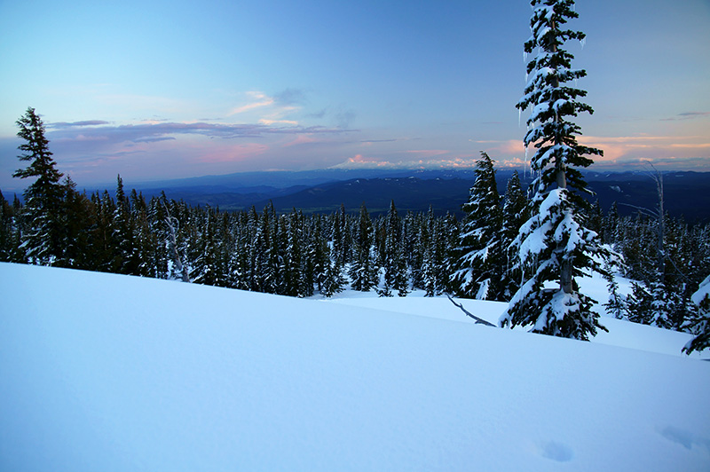
* Mt. Hood from camp at 6400' the first night
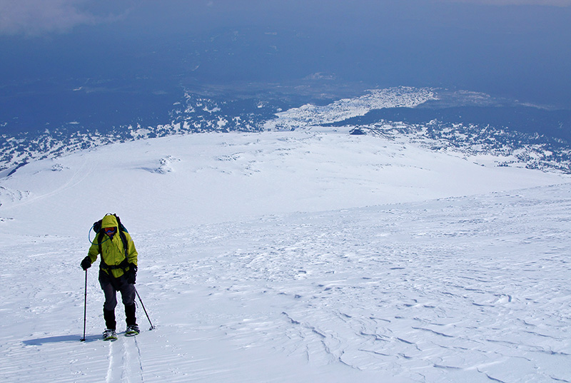
* My partner at around 11,000'
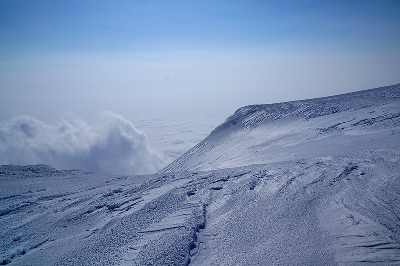
* Sea of clouds from the false summit, looking towards the Southwest Chutes
Road to Cold Springs is snow clear until about five miles out, about a mile until the single lane portion. The double lane portion has large snow-free gaps that make skinning aggravating - on the way down I put my board on my back and switched to snowshoes at the first gap, snowshoeing about 3/4 mile, then hand carried the snowshoes for about the last half mile. Probably the half mile closest to the cars will melt out in the next little while (1-2 weeks?), then the next 3/4 mile will go, but I'm guessing beyond that will take somewhat longer to melt, depending on what happens with the weather, but calling the ranger station while they're open is probably the best bet for current conditions.
Morrison Creek campground was under five and a half feet of snow, but the outhouse was still open (bring TP).
The conditions on the ascent itself were good to great. We got a decidedly non-alpine start after one of worst nights sleeping in my life, starting our ascent at 7:40 AM, munching our breakfast of once-soft German pretzels (high in carbs, no-prep and the only thing my stomach could handle that morning). I skinned up on my aging 2004 Burton S-Series splitboard while my partner was boardless on MSR Lightning Ascent snowshoes, and we both found easy going on the mildly breakable crust, with the three other climbers in our party (all on MSR Lightning Ascents) catching us at South Butte. I took us a little too high on South Butte and I had to do a few free-heeled jump turns down a short but somewhat steep and icy section (we should've gone around a little lower on climber's left). As an aside, the cornices to the west of Crescent Glacier were big and menacing looking, which was why everybody was avoiding that part of the mountain.
Two of our party ascended the rib in the middle of the face above Lunch Counter, but it looked too steep for me to skin up, so I led my partner and Red Mustache up an ascending east traverse, which added distance but was manageable with somewhat non-grippy skins. Red Mustache and my partner turned around partway up the interminable face, and I switched to snowshoes at about 11,100' when I started having trouble gripping. This is when my partner and I came across our friends Grey Parrot and Yanni descending from Piker's Peak (the false summit). My partner descended with them on foot, while I pressed on with my (way too heavy) board on my back and a donated liter of water (thanks Yanni!). I arrived at the false summit with a throbbing headache from altitude, exertion, and probably some dehydration (3.25 liters in). I took some photos and video with my also heavy camera (I really should consider some lighter equipment), eyed the Southwest Chute, but ruled it out as too reckless for my taste to descend alone at the late hour with clouds moving in and out and unknown stability. Not to mention my questionable judgment... So I put myself together as best I could and launched into the 5200 vertical foot descent to camp. The first 2000 vertical was OK - I found channels of powder amidst the crunchiness, but the next 1000-1500 vertical feet above the South Butte could best be described as killer sastrugi. My tired legs weren't huge fans, especially descending alone, the last one off the mountain, and not super confident of the way back to camp. But I fortunately caught up to my friends right about where the snow softened up a little above South Butte, and I started to really enjoy myself, launching off the little windlips and enjoying the creamy corn.
Snowboarding down from our camp at around 6400 feet the next morning was good, but it's easy to lose the trail if you don't stick with it, and I discovered that jumping with a weekend pack is a dicey if nonetheless irresistible endeavor. I ended up following a snowmobile track east farther than I wanted and had to hike about fifty feet before strapping in again. That annoyed me, so I vowed to stay to the west, went too far and lost all tracks. I was tempted to just keep going and hopefully find my way, but decided that's how all rescue stories begin, so I instead pulled out my GPS and realized that I had already gone way past Cold Springs, but was only 400 vertical directly above the road out. So I dropped straight down through the very tight and steep trees and blowdown to the road, which was unexpectedly interesting with a weekend backpack on my back. Even though I had my ski poles out and could make some pretty decent ski-style jump turns, there were a couple of places where I sideslipped ten feet or so (shhh, don't tell anyone). :) That section could become non-navigable real fast (if you could call it navigable now - my last 400 vertical were probably out of shape yellow-caution/side country difficulty if it were a ski area). I'm not sure if heading straight down Morrison Creek from the Southwest Chute would be better or worse, but I'd keep it in mind that you could run into blowdown and melt-out below 5000 feet or so (as of Monday).
I popped out literally right in front of the fastest of our snowshoers who had left 20 minutes ahead of me, and I proceeded to pole and ride down the road all the way to the outhouse at Morrison Creek (I think I walked 5-10 feet but really did a lot of poling) beating them by another 10-15 minutes, so I guess the poling went faster than skinning maybe.
Overall it was a great trip, and there's plenty of snowpack up there for a lot more weekends.
Photos
* Mt. Hood from camp at 6400' the first night
* My partner at around 11,000'
* Sea of clouds from the false summit, looking towards the Southwest Chutes
Dude thats awsome. I almost went up that weekend too!!!! I looked at the weather and it said cloudy and snowing. Did you run into any of that up there? Good TR btw!
The weather came in and out. On Saturday evening a thunderstorm went by us to the south but missed us. Sunday was variable visibility, but no precip where we were. One party turned around just below Lunch Counter reporting that you couldn't see a thing, but we had mostly good visibility. When I was on the false summit clouds were coming in and out around the summit, and the cloud deck kept enveloping treeline, which made me a little (more) nervous about my descent - I was concerned that I could get into a whiteout at any moment, but the weather held. It was, however, very windy most of the way above South Butte. Hope this helps!
Thanks for this TR, Jason. Myself and some buddies are thinking of heading up Adams for a summit attempt this weekend, and were curious as we hadn't seen any other TRs yet.
Ranger at Trout Lake station said today that there was some slide activity below the Lunch Counter. Did you guys see any slide activity, and if so, any idea if it was wet snow slides or slab?
Appreciate the beta.
Ranger at Trout Lake station said today that there was some slide activity below the Lunch Counter. Did you guys see any slide activity, and if so, any idea if it was wet snow slides or slab?
Appreciate the beta.
We didn't see any slide activity at all (I don't think it warmed up enough except at treeline and below), but there were a lot of cornices on the Crescent Glacier, and one on the southeast edge of the false summit. If it gets really warm I'd keep a close eye on things, and definitely bring a transceiver and shovel. Also keep some reserves and time for the true summit - it's quite a ways still from the false summit. Have a great time and let us know how it goes!
Great, thanks for the info. It's forecasted to be quite warm relative to last weekend, so we'll make sure to be very observant on the mountain.
If all goes well, hopefully we'll have a great TR for you come early next week!
If all goes well, hopefully we'll have a great TR for you come early next week!
Reply to this TR
Please login first: