May 20, 2011, Mt. Townsend, Olympics, North Side
5/20/11
WA Olympics
2838
4
In search of the ever elusive back door into the the higher Olympics, two of us took a shot at the northern approach to Mt. Townsend. This approach starts from Bon Jon Pass, ....only 1/2 hour from Sequim, which was appealing to me. We got started a little late at 8AM and skinned right out of the truck remarkably at Bon Jon at 3000 feet. That proved a little optimistic, but after about a mile up the forest road (2820 I think), we were on a foot or so of rapidly softening snow.
It is a very flat 4-5 miles of road skinning, mostly above 4000 feet, till you hit a creek coming right off the summit ridge. That is where the climb really starts. We easily forded the creek at about 4200 feet, where there was 3-5 feet of snow. We dealt with some tight trees for a couple hundred yards traversing, then headed straight up a very steep gully that looked to terminate to the left of a major spine off the summit ridge.
Gully was a major bear in deep slush; no good choice on the ascent, post hole-boot pack, or multiple tight lumbar-irritating switch backs. Above the gully at say 4600 feet, things opened up nicely, and we skinned up to about the 5500 foot level, running out of time and/or energy to gain the ridge. There was some very nice low angle gladed skiing up there, but descent was pure survival for me in feet of slush on my narrow corn skis.
Net, this looks like a good 10 + mile XC tour, better than obstruction as more gradual. As for the summit, need to hit this very early in the AM after a hard freeze, and as with most Olympics, a long approach.
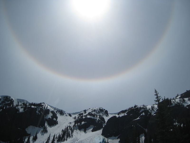
note, 2nd photo was a pretty cool "22 degree ice halo" from the overrunning cirrus.
It is a very flat 4-5 miles of road skinning, mostly above 4000 feet, till you hit a creek coming right off the summit ridge. That is where the climb really starts. We easily forded the creek at about 4200 feet, where there was 3-5 feet of snow. We dealt with some tight trees for a couple hundred yards traversing, then headed straight up a very steep gully that looked to terminate to the left of a major spine off the summit ridge.
Gully was a major bear in deep slush; no good choice on the ascent, post hole-boot pack, or multiple tight lumbar-irritating switch backs. Above the gully at say 4600 feet, things opened up nicely, and we skinned up to about the 5500 foot level, running out of time and/or energy to gain the ridge. There was some very nice low angle gladed skiing up there, but descent was pure survival for me in feet of slush on my narrow corn skis.
Net, this looks like a good 10 + mile XC tour, better than obstruction as more gradual. As for the summit, need to hit this very early in the AM after a hard freeze, and as with most Olympics, a long approach.
note, 2nd photo was a pretty cool "22 degree ice halo" from the overrunning cirrus.
Nice photos, wish it was like that for us on Townsend Sunday.
Do you have a number for that FS road? And is any of your route in the first photo?
Do you have a number for that FS road? And is any of your route in the first photo?
Thanks for the beta ................ this is one of the tours "on our list". Nice pictures too .........
Gary
Gary
yep, is forest road 2820. Directions are on this page, little quilicene access. hike #835. http://www.olympicforest.org/hiking_guide.htm
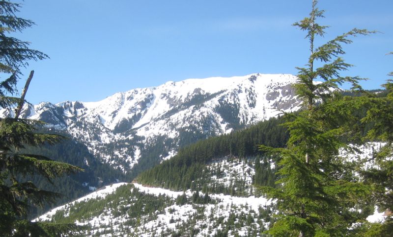
re route, nearly all the route is in the first photo, taken from about 3 miles into FR 2820 from a high point. In photo, you see FR 2820 continuing, just above where the road turns right behind the forested ridge, is the gully we hiked. I can send a photoshopped version with route if you want via PM.
re route, nearly all the route is in the first photo, taken from about 3 miles into FR 2820 from a high point. In photo, you see FR 2820 continuing, just above where the road turns right behind the forested ridge, is the gully we hiked. I can send a photoshopped version with route if you want via PM.
yeah .. thx for the beta ..
Reply to this TR
Please login first: