May 8, Dungeness Area, ONP
5/15/11
WA Olympics
3895
6
Likely due to the lousy spring weather as of late, I'm finding that I've been green-lighting backcountry trips despite wet weather forecasts and lack of planning.
Inspired by a small amount of light making it through my bedroom window, I made a 6am call to Gary, and a short drive later we were at the upper dungeness trailhead with intentions to climb up to the ridge between the Dungeness River and Royal Basin. After a few miles of trail we made an assault on the ridge, battling trees, post-holing through 175# crust, and eventually gaining the ridge. In the alpine we found ourselves wallowing in clouds with occasional breaks. Without visibility, we stopped for lunch and I mentally gave up on the tour and prepared for a descent back to the car.
Gary, however, expressed his interest in finishing the tour to Royal Basin, rain or shine, day or night. Not to be the Sally Sadsack of the day, I reluctantly agreed to use the next sucker hole to get to the saddle across the basin where we could hopefully get a view into Royal. Unexpectedly, once there the clouds cooperated long enough that we were able to get a 2200' descent into Royal Basin on a spring-ish snowpack of mostly corn with a little of mush towards the lower elevations. We crossed the creek to the summer hiking trail, refilled our water, and prepared for skiing down the trail.
What should have been an easy hike out was actually a brutal skin/ski/hike through very heavy snowpack and massive avi debris. The avalanche chute on the trail was strewn with large trees, rock, and piles of snow that were at least 30' high and had slid over full path and into old[er] growth forest at the edges of the paths. Impressive, but frustrating to navigate at the end of the day. We again faced breakable crust as our last battle of the day before finding bare trail somewhere between 3000' and 3500'.
The taste of the beer at the car was great.
Pics didn't turn out great, but here are a few:
1: Picture of the route ahead
2: Another picture of the route ahead
3: Battling a debris pile on the retreat.
Beautiful and mysterious area. Doesn't look like a fun escape!
author=chmnyboy link=topic=20796.msg88684#msg88684 date=1305092513]Not to be the Sally Sadsack of the day
Let's be honest, this was a foregone conclusion given you were with GaryJan ;)
Regardless, nice work getting out despite the weather. I'm guessing the snow pack was fat up in Royal Basin!
The Debris field, wow. Just wow!
Tyler’s early morning rally call provided a great opportunity trade a week’s worth of sea level’s challenges for a day spent traveling in the beautiful high alpine terrain of the eastern Olympics. Good call on the weather and the destination! :)
Our goal for the day was the ridge line above Goat Lake and a ski descent into Royal Basin. This beautiful high alpine lake is nestled in a cirque at about elev. 6,000 ft just east of the ridge line which separates the Dungeness River drainage from Royal Basin. The standard route is to follow the Dungeness River to Camp Handy and then ascend a steep trail through dense forest and brush to the lake.
An alternate, less traveled option is to leave the Dungeness trail a short ways after crossing Royal Creek and climb to the ridge line through steep and variable terrain, there is no established route. We were fortunate to climb through mostly open, old growth forest. The boot packing through the lower elevation snow was difficult and frustrating. Almost simultaneously, at around elev.4,500 ft we agreed switching to skis would relieve much of our anxiety. The last 1,000 ft up to the ridge, although steep was much easier traveling on skis.
At the ridge line, we were greeted with periods of blue sky and intermittent views of the peaks deeper in the Olympics. This provided the motivation to climb the next 1,500 vf to the first of two unnamed peaks on the approach to Goat Lake. As we approached this peak, clouds from the NW started rolling over us, obscuring our views and creating uncertainty on how we should proceed.
As Tyler reported, at this point, we assessed our options. Of our 3 choices, short cutting across the basin north of Goat Lake to our originally planned descent route into Royal Basin seemed like the best choice. We were fortunate the weather cooperated. The views into upper Royal Basin were beautiful. Technical difficulties with both of our cameras prevented documenting much of what we saw.
The ski down into the basin was enjoyable on the smooth steep slope. We skied on continuous snow to about 3,300 ft elev. The bottom of the “No Fire” sign at 3,500 ft was barely above the snow.
A couple of approach notes;
• There is a rock slide across the road about a mile before the Dungeness trailhead. It is passable with a higher ground clearance vehicle.
• As Tyler reported, where the Royal Creek trail crosses avalanche paths, there are significant debris piles. Some of these include rocks and trees. This made for slow and tedious travelling.
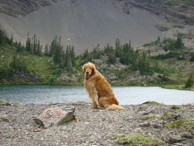
Finally, our Golden Retriever, Abby passed away today. She was 13 and had been an enthusiastic companion on many of our mountain travels for much of her life. She loved every opportunity to join us on an adventure, we already miss her ,,,,,,,,,,,,,,
A few more pictures;
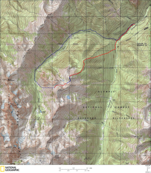
1. A map of our route. Red is up, blue is down.
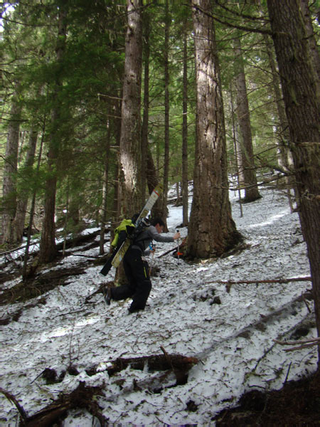
2. Tyler post holing on our initial climb
3. Abby at Goat Lake, July, 2009
Gary
Our goal for the day was the ridge line above Goat Lake and a ski descent into Royal Basin. This beautiful high alpine lake is nestled in a cirque at about elev. 6,000 ft just east of the ridge line which separates the Dungeness River drainage from Royal Basin. The standard route is to follow the Dungeness River to Camp Handy and then ascend a steep trail through dense forest and brush to the lake.
An alternate, less traveled option is to leave the Dungeness trail a short ways after crossing Royal Creek and climb to the ridge line through steep and variable terrain, there is no established route. We were fortunate to climb through mostly open, old growth forest. The boot packing through the lower elevation snow was difficult and frustrating. Almost simultaneously, at around elev.4,500 ft we agreed switching to skis would relieve much of our anxiety. The last 1,000 ft up to the ridge, although steep was much easier traveling on skis.
At the ridge line, we were greeted with periods of blue sky and intermittent views of the peaks deeper in the Olympics. This provided the motivation to climb the next 1,500 vf to the first of two unnamed peaks on the approach to Goat Lake. As we approached this peak, clouds from the NW started rolling over us, obscuring our views and creating uncertainty on how we should proceed.
As Tyler reported, at this point, we assessed our options. Of our 3 choices, short cutting across the basin north of Goat Lake to our originally planned descent route into Royal Basin seemed like the best choice. We were fortunate the weather cooperated. The views into upper Royal Basin were beautiful. Technical difficulties with both of our cameras prevented documenting much of what we saw.
The ski down into the basin was enjoyable on the smooth steep slope. We skied on continuous snow to about 3,300 ft elev. The bottom of the “No Fire” sign at 3,500 ft was barely above the snow.
A couple of approach notes;
• There is a rock slide across the road about a mile before the Dungeness trailhead. It is passable with a higher ground clearance vehicle.
• As Tyler reported, where the Royal Creek trail crosses avalanche paths, there are significant debris piles. Some of these include rocks and trees. This made for slow and tedious travelling.
Finally, our Golden Retriever, Abby passed away today. She was 13 and had been an enthusiastic companion on many of our mountain travels for much of her life. She loved every opportunity to join us on an adventure, we already miss her ,,,,,,,,,,,,,,
A few more pictures;
1. A map of our route. Red is up, blue is down.
2. Tyler post holing on our initial climb
3. Abby at Goat Lake, July, 2009
Gary
nice work you guys .. thx gary for the beta on those hikes up to goat lake .. and very sorry for the loss of sweet abby ... i feel your pain .. still missing our mountain companion after many yrs
That looks like a fun out of the way approach! We went up and down near your descent route, but I've always wanted to get back to that area.
Royal Basin always dishes it out. But this year is the year...
Thanks for the report!
Royal Basin always dishes it out. But this year is the year...
Thanks for the report!
Reply to this TR
Please login first: