April 22-23, 2011, Cannon-Cashmere Medly
4/22/11
WA Cascades East Slopes Central
16127
15
I guess it's no big surprise to see the explosion of TR's coming out, given our first stable day of consistently good weather. I must say it's refreshing to see so many people getting out to capitalize on this all too elusive sunshine!
But the solid forecast is a mixed blessing of sorts. There were so many choices of tours and descents, it was a bit overwhelming to narrow down the options. So, to keep it simple, Dan Helmstadter and I chose to stay local. Of course, "local" for Dan is anywhere there is steep and deep. For me, local is 10 miles SSW of Leavenworth.
I've had my eye on a slick looking couloir north and east of the CMC on Cannon Mtn. this season.
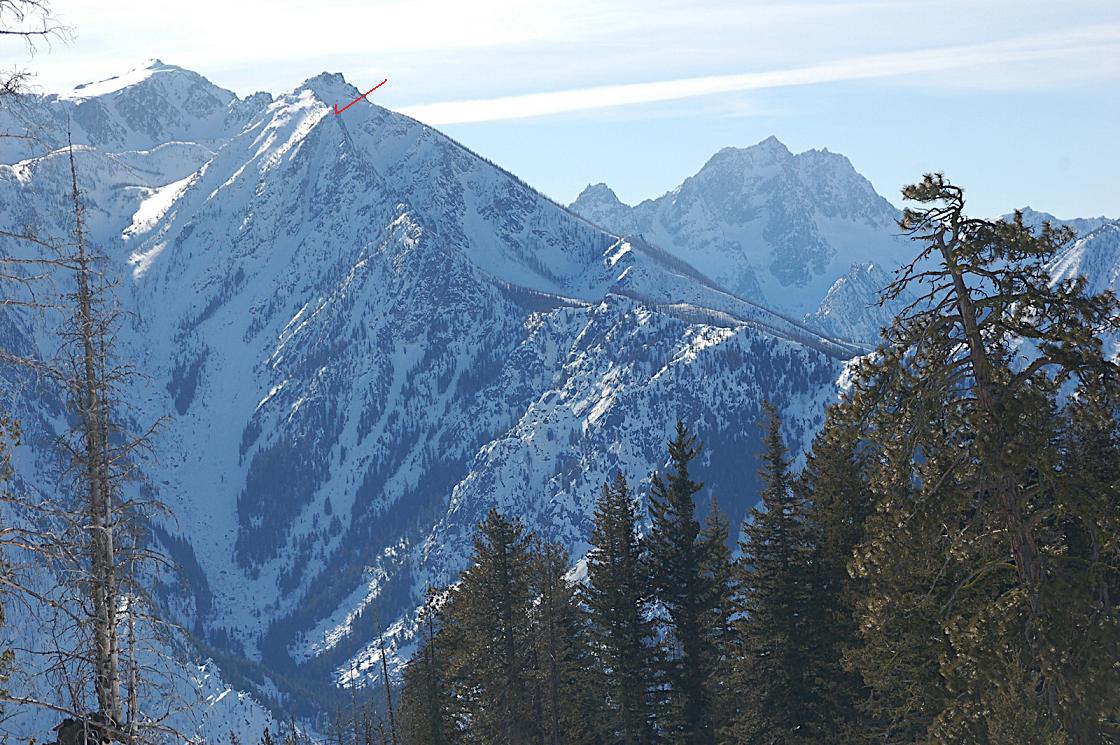
With two days on our hands, we decided on a carryover, making turns where we could find them on Cannon Mtn. and Mt. Cashmere. And given the current access restrictions, a boot up the Rat Creek made for a perfect gateway to the plan. By 3:30am, Dan and I were beating our way up the infamous Rat, passing by Rat Creek Dome and pondering routes to be done if/when summer rolls around. Without too much hassle, we were kicking steps up the NE Couloir.
[img width=563 height=800">http://www.cascadeclimbers.com/plab/data/500/cc5.jpg" />
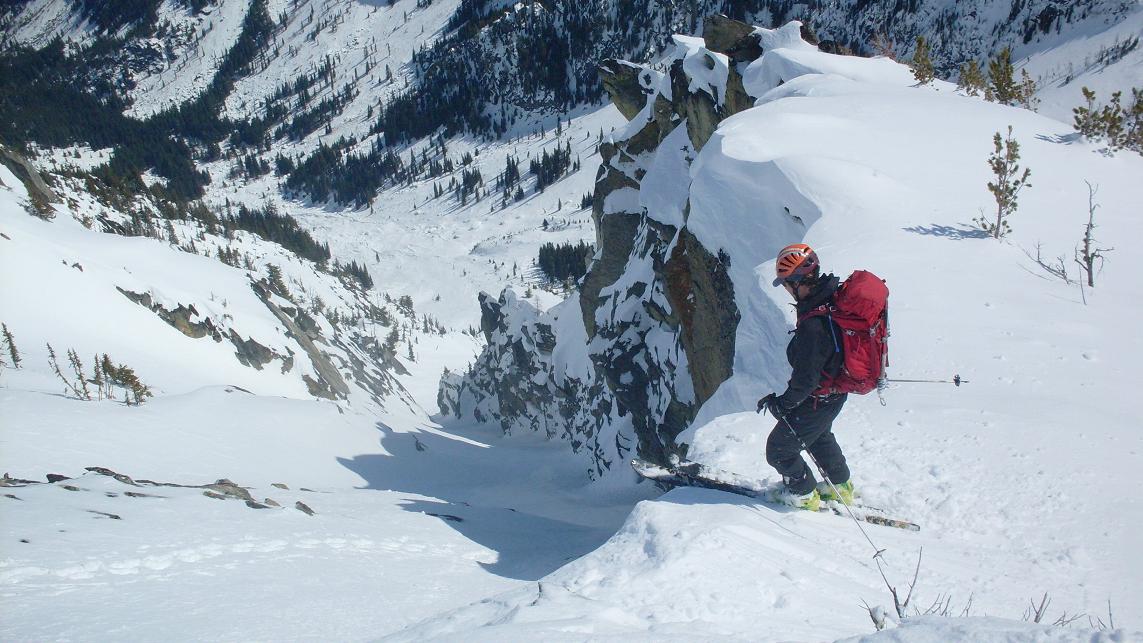
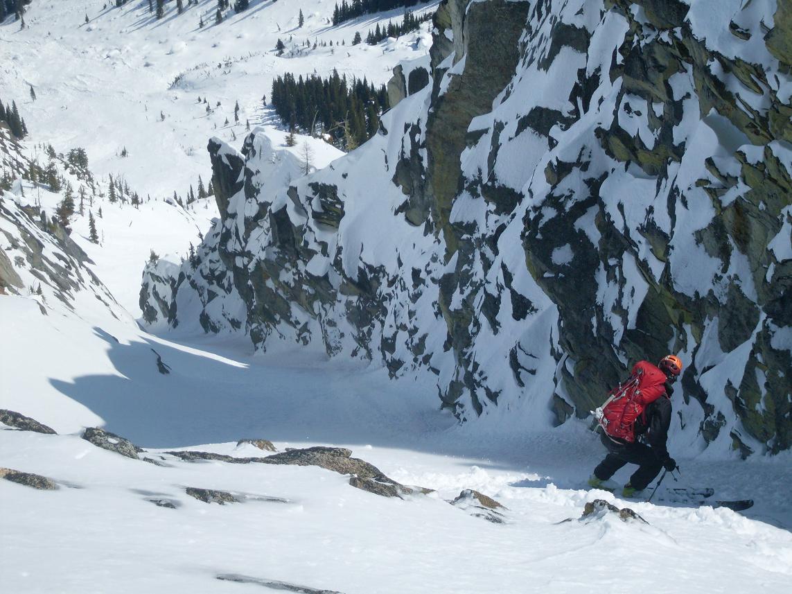
This gully tops out at a nice little vantage point, giving a spectacular view down to Leavenworth, over at the Hook Creek Crags and NE Face of Cashmere. Barring a few exposed rocks, it was a worthy descent. Mr. Smooth leading the way...
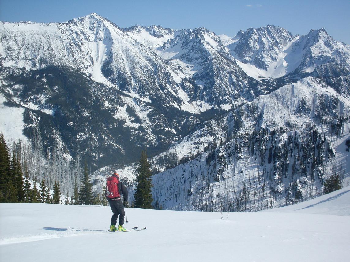
Pleased with the effort, but not content, we continued on to a perch just north of Coney Lake. From there, we kicked steps up to the top of the CMC, our exit to the planned bivi near Eightmile Lake T.H. Views. Can you believe it?!
[img width=1000 height=532">http://www.cascadeclimbers.com/plab/data/500/cc20.jpg" />
Dan smoothing down the CMC.
[img width=599 height=800">http://www.cascadeclimbers.com/plab/data/500/cc23.jpg" />
We set up camp about .5 miles from the eightmile lake TH, pondering the next day, which was forecast to be 10F warmer than Friday. This could be troublesome, since our approach would be up the south slopes of Mt. Cashmere.
Dan, ever the grateful ski partner, endured my morning ambivalence until I had my coffee and quit being a whiny little punk and we got going an hour and a half later than we had wanted. The going was easy since we chose the correct goat hiway. As Andy Dappen penned, it was a "Marlboro Backdrop" type day.
[img width=599 height=800">http://www.cascadeclimbers.com/plab/data/500/cc24.jpg" />
A few hundred feet below the summit, we reached the top of the north couloir of Cashmere.
[img width=599 height=800">http://www.cascadeclimbers.com/plab/data/500/cc26.jpg" />
Down which we skied the last of the east side powder for the season??
[img width=599 height=800">http://www.cascadeclimbers.com/plab/data/500/cc27.jpg" />
Dan threw down and kicked steps back up the couloir so we could dispense of the south couloir of Mt. Cashmere. Given its exposure to, well, south the snow was soft and forgiving and allowed the best turns of the two days. But not before we touched the top.
[img width=599 height=800">http://www.cascadeclimbers.com/plab/data/500/cc33.jpg" />
And then a fantastic, worry-free descent.
[img width=841 height=800">http://www.cascadeclimbers.com/plab/data/500/cc39.jpg" />
And the creamy goodness of WA corn and sunshine, Washington's most precious resources.
But the solid forecast is a mixed blessing of sorts. There were so many choices of tours and descents, it was a bit overwhelming to narrow down the options. So, to keep it simple, Dan Helmstadter and I chose to stay local. Of course, "local" for Dan is anywhere there is steep and deep. For me, local is 10 miles SSW of Leavenworth.
I've had my eye on a slick looking couloir north and east of the CMC on Cannon Mtn. this season.
With two days on our hands, we decided on a carryover, making turns where we could find them on Cannon Mtn. and Mt. Cashmere. And given the current access restrictions, a boot up the Rat Creek made for a perfect gateway to the plan. By 3:30am, Dan and I were beating our way up the infamous Rat, passing by Rat Creek Dome and pondering routes to be done if/when summer rolls around. Without too much hassle, we were kicking steps up the NE Couloir.
[img width=563 height=800">http://www.cascadeclimbers.com/plab/data/500/cc5.jpg" />
This gully tops out at a nice little vantage point, giving a spectacular view down to Leavenworth, over at the Hook Creek Crags and NE Face of Cashmere. Barring a few exposed rocks, it was a worthy descent. Mr. Smooth leading the way...
Pleased with the effort, but not content, we continued on to a perch just north of Coney Lake. From there, we kicked steps up to the top of the CMC, our exit to the planned bivi near Eightmile Lake T.H. Views. Can you believe it?!
[img width=1000 height=532">http://www.cascadeclimbers.com/plab/data/500/cc20.jpg" />
Dan smoothing down the CMC.
[img width=599 height=800">http://www.cascadeclimbers.com/plab/data/500/cc23.jpg" />
We set up camp about .5 miles from the eightmile lake TH, pondering the next day, which was forecast to be 10F warmer than Friday. This could be troublesome, since our approach would be up the south slopes of Mt. Cashmere.
Dan, ever the grateful ski partner, endured my morning ambivalence until I had my coffee and quit being a whiny little punk and we got going an hour and a half later than we had wanted. The going was easy since we chose the correct goat hiway. As Andy Dappen penned, it was a "Marlboro Backdrop" type day.
[img width=599 height=800">http://www.cascadeclimbers.com/plab/data/500/cc24.jpg" />
A few hundred feet below the summit, we reached the top of the north couloir of Cashmere.
[img width=599 height=800">http://www.cascadeclimbers.com/plab/data/500/cc26.jpg" />
Down which we skied the last of the east side powder for the season??
[img width=599 height=800">http://www.cascadeclimbers.com/plab/data/500/cc27.jpg" />
Dan threw down and kicked steps back up the couloir so we could dispense of the south couloir of Mt. Cashmere. Given its exposure to, well, south the snow was soft and forgiving and allowed the best turns of the two days. But not before we touched the top.
[img width=599 height=800">http://www.cascadeclimbers.com/plab/data/500/cc33.jpg" />
And then a fantastic, worry-free descent.
[img width=841 height=800">http://www.cascadeclimbers.com/plab/data/500/cc39.jpg" />
And the creamy goodness of WA corn and sunshine, Washington's most precious resources.
that's a great, great trip you two. I love it.
Way to get after it!
love looking at the pictures here at work on a rainy Monday ! wonderful!
Nice work John. I can see why you wanted ski that line!
In regards to the approach, they still have some work to do to clear the road I assume?
In regards to the approach, they still have some work to do to clear the road I assume?
Thanks Kevin! I left out the carnage about the deproach. As you know, the mudslide closed the road about 1.5 miles from 8 mile road. On top of that, there are two miles of dry road to hike back to bridge creek c.g. We ended up hiking a total of about 4 miles back to 8 mile c.g. The climbers scratching up classic crack looked at us as if we were aliens as we walked by with skis and boots.
Well done. North side of Cannon Mtn looks interesting in your last pic.
author=jwplotz link=topic=20638.msg87976#msg87976 date=1303749204]
The climbers scratching up classic crack looked at us as if we were aliens as we walked by with skis and boots.
That's awesome...
Strong work guys. Very cool.
WOW, great photos and TR.
It kills me to look at this - while at work. ;)
nice pics John. looks like some fun lines!
Strong effort for what must have been some great turns.
I would love to ski some of those couloirs myself. Thanks for all the great photos.
I would love to ski some of those couloirs myself. Thanks for all the great photos.
Strong work, John & partner! You like those long snaky lines. What is the broad gully to the left of your couloir (skier right)? It seems as though it's full of avy debris and/or rock. N
author=niko link=topic=20638.msg88006#msg88006 date=1303773707]
Strong work, John & partner! You like those long snaky lines. What is the broad gully to the left of your couloir (skier right)? It seems as though it's full of avy debris and/or rock. N
Hey Niko! That is Rat Creek.
Thanks for the great trip and your photos John!


RADDD!
Sorry I didn't join you. Beautiful lines, though it appears you added a few coolers and several miles to the original plan? Way to take advantage of the good weather.
High fives all around!
Sorry I didn't join you. Beautiful lines, though it appears you added a few coolers and several miles to the original plan? Way to take advantage of the good weather.
High fives all around!
Reply to this TR
Please login first: