April 9, 2011, Stuart, Cascadian Couloir
4/9/11
WA Cascades East Slopes Central
9477
15
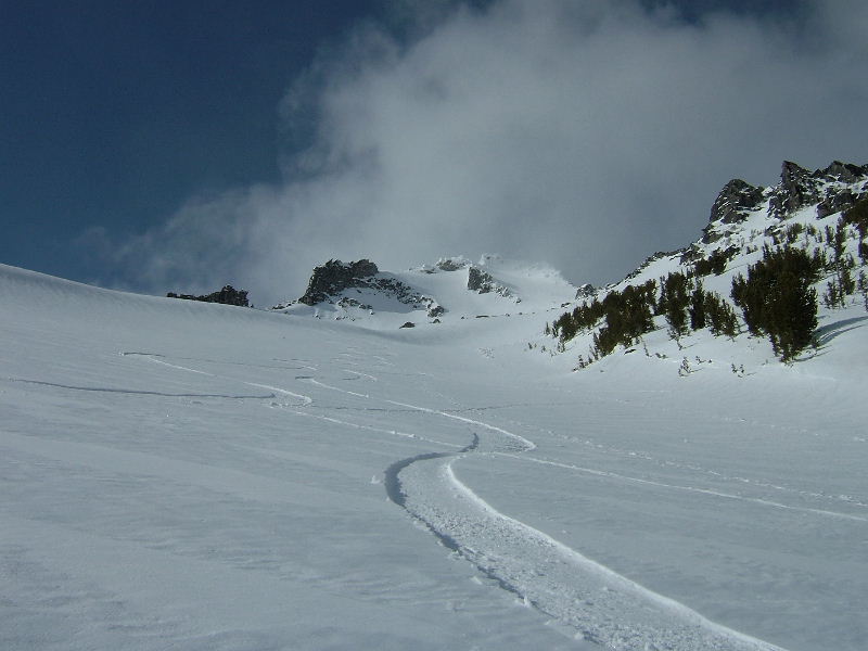
Waited a couple hours for "film boy" to show up and we were off to Teanaway with hopes of beating the next storm. Sign at 29 Pines said road closed due to logging, but we thought that was finished and looked like that maybe only pertained to M-F. Next two obstacles were an icy berm blocking the road and no snow on the road. 4-Runner cleared the burm after a little ice axe work and we made it past Stafford Creek to consistent snow and executed the 5 step trailer/truck turn. Only four hours sleep and we were off. Up to Long's Pass was fairly easy, but the wind and snowfall made it feel like the next system had already arrived and perhaps we were wasting our time. Our hopes were bolstered as a bit of sun lit up our slope for the powder run down to Ingall's Creek and again while taking a food break at the creek in warm sunshine. It would have been more efficient to go to the bottom of Cascadian and up from there, but we did a rising traverse on harder than expected crust leading Kyle to crampon/boot pack the rest of the climb. I did some boot packing, but managed another 1500' of skinning with crampons from about 6400' before submitting to crampons/booting again. Weather kept going in and out of shade and sun and the summit stayed mostly in the cloud deck. Snow up high was a very nice wind pack and soft and to our surprise and delight the sun had perfectly corned up the rest of the mountain making for a smooth fast ride of more than 4000' from the false summit to Ingall's Creek. We ate and reveled in the accomplishment before setting out on the grueling 1500' one foot in front of the other climb back up to Long's. Unfortunately the clouds came in and the sun was waning so the drop back down to Teanaway was horrible, breakable crust. Fortunately, the memory of the powder run and the Cascadian Couloir will outlive the memory of the crust :). Hopefully Kyle has some video to add.
STATS: 8000', three runs, and about 14 hours. Lost snowboards: one. Not mine ;D.
STATS: 8000', three runs, and about 14 hours. Lost snowboards: one. Not mine ;D.


Awesome! Thanks for sharing.
author=Boot link=topic=20495.msg87234#msg87234 date=1302485397]
Waited a couple hours for "film boy" to show up and we were off to Teanaway with hopes of beating the next storm.
this cracked me up ... sorry for your wait though .. nice to meet you ..
your photos are beautiful .. i was wondering all day how it was going for you guys ... a 4K' ride sounds awesome
can't wait to see the video
good job guys!
Awesome! Nice work getting out there. Love that you found good snow...but bummer about the clouds coming in. The view is amazing from up there.
Thanks for the road update! I think the N. Fork Teanaway is going to look a lot different next time I see it. Lot's of logging on the North side. Did you guys ascend Cascadian? It looks to me like your turns down are in the "variation" that faces more East? Just wondering...
PSA: Per calls to Cle Elum RD yesterday and today (509) 852-1100, the NF Teanaway Road is closed at 29 Pines. Some of us wanted to go up there to ride in and ski but do not really want to snowmobile over a mile or two of rocks to get to the snow. If we ever get a good weather stretch we may go self-powered overnight.
Apparently, there is an "extended Road Closure on Naches District and Cle Elum District Roads", "there is not money to fix Road damage." Also, "the LEO says he will ticket for the Road closure violations."
I asked and emailed also asking for Cle Elum RD to consider moving the NF Teanaway closure back on the dry part of the Road so that we can access the snow for skiing and snowmobiling.
Sorry been super busy but here is a video of the Cascadian.
http://vimeo.com/22217023
http://vimeo.com/22217023
Cascadian "variation" as per Becky guide would be a better description. Correct me if I am wrong.
WMC. The TR states that they chipped away at the berm and made it to Stafford Cr. So, head on up! "Extended road closures" apply to damaged roads. Take a pic of the logging if you go. I would like to see how your proposed closure area looks now! Maybe some roads go higher on the North side of the river...
Ventured up the road last Sunday. The road was bare to beyond the guard station and past the bridge and cabins just upstream. There is some minor washout damage here and there. Saw a couple of vehicles, including a low-slung Subaru that somehow crawled over the berm.
author=TobyT link=topic=20495.msg87495#msg87495 date=1302883487]
Cascadian "variation" as per Becky guide would be a better description. Correct me if I am wrong.
I agree, looks like the S Shoulder, not the Cascadian. I'm jealous in either case!
author=TobyT link=topic=20495.msg87496#msg87496 date=1302883949]
WMC. The TR states that they chipped away at the berm and made it to Stafford Cr. So, head on up! "Extended road closures" apply to damaged roads. Take a pic of the logging if you go. I would like to see how your proposed closure area looks now! Maybe some roads go higher on the North side of the river...
Yes, understood from the first, thanks. I called Cle Elum RD two days in a row and they are telling me that they will write tickets, that road is closed. I agree if it is dry it should be opened, but that is what I was told. I posted the Cle Elum RD number if you guys want to check. Please post if there is a different situation according to the USFS. They say an official opening is complicated, and etc, and the LEO says he will write tickets....glad you all had fun but that is what they are telling me. Wait-maybe it is just closed to WMC ;D
author=Boot link=topic=20495.msg87234#msg87234 date=1302485397]
STATS: 8000', three runs, and about 14 hours. Lost snowboards: one. Not mine ;D.
Strong work fellas. I wouldn't mind hearing the lost snowboard story...
Nice work! The year of the Couloir!
Great report Toby. Have to put this on the To Do list. Looks outstanding.
Reply to this TR
Please login first: