- Posts: 635
- Thank you received: 0
Mount Rainier Paradise reaches 200" snow depth
- Amar Andalkar
- [andalkar]
-
 Topic Author
- Offline
- Premium Member
-

Less
More
10 Mar 2011 15:14 - 10 Mar 2011 16:41 #198747
by Amar Andalkar
Mount Rainier Paradise reaches 200" snow depth was created by Amar Andalkar
Looks like Paradise won a narrow, come-from-behind victory this morning over Mount Baker Ski Area in the race to be the first telemetry site in the Cascades to reach 200" of snow depth this season:
Northwest Weather and Avalanche Center
Paradise, Mt Rainier National Park, Washington
MM/DD Hour Temp RH Wind Wind Wind Hour Total 24 Hr Total Solar
PST F % Avg Max Dir Prec. Prec. Snow Snow W/m2
5550' 5550' 5500' 5500' 5500' 5550' 5550' 5550' 5550' 5500'
3 9 1500 33 100 21 31 272 .04 .09 5 187 115
3 9 1600 33 100 18 24 271 .06 .15 5 187 63
3 9 1700 33 100 14 22 267 .06 .21 5 187 26
3 9 1800 33 100 13 20 265 .04 .25 4 186 10
3 9 1900 33 100 12 18 267 .05 .3 6 186 0
3 9 2000 33 100 8 14 275 0 .3 5 187 0
3 9 2100 33 100 4 10 301 .06 .36 7 186 0
3 9 2200 33 100 10 18 295 .08 .44 7 187 0
3 9 2300 33 100 12 19 289 .12 .56 8 190 0
3 10 0 32 100 16 27 283 .11 .67 10 192 0
3 10 100 32 100 17 28 280 .06 .73 10 194 0
3 10 200 32 100 14 23 275 .11 .84 11 194 0
3 10 300 32 100 12 18 277 .12 .96 12 197 0
3 10 400 32 100 14 23 275 .11 1.07 14 199 0
3 10 500 31 100 16 24 271 .09 1.16 14 201 0
3 10 600 28 100 18 28 271 .1 1.26 17 202 0
3 10 700 27 100 24 36 277 .06 1.32 19 203 1
3 10 800 27 100 16 25 279 .03 1.35 19 203 21
3 10 900 28 100 13 21 263 .05 1.4 19 203 71
3 10 1000 30 99 14 22 273 .01 1.41 19 202 143
3 10 1100 31 99 17 26 273 0 1.41 19 201 314
3 10 1200 32 98 19 28 275 0 1.41 1 196 462
3 10 1300 30 99 15 26 263 0 1.41 1 196 368
3 10 1400 29 100 21 36 271 .02 1.34 1 195 240
3 10 1500 28 100 20 33 263 .05 1.33 1 196 86
3 10 1600 27 100 23 40 269 .05 1.38 2 196 65
Northwest Weather and Avalanche Center
Mt Baker Ski Area, Washington
Wind sensors unheated and may rime
Precip gage appears to be under-recording 2-27-2011
MM/DD Hour Temp Temp RH RH Wind Wind Wind Wind Hour Total 24 Hr Total
PST F F % % Min Avg Max Dir Prec. Prec. Snow Snow
5000' 4210' 5000' 4210' 5000' 5000' 5000' 5000' 4210' 4210' 4210' 4210'
3 9 1500 31 33 100 100 11 19 34 249 0.11 0.26 1 190
3 9 1600 31 33 100 100 11 21 31 190 0.10 0.36 1 191
3 9 1700 30 33 100 100 13 24 42 193 0.08 0.44 2 192
3 9 1800 30 33 100 100 5 21 40 202 0.05 0.49 2 192
3 9 1900 30 33 100 100 12 27 51 181 0.10 0.59 2 191
3 9 2000 29 33 100 100 8 22 44 252 0.05 0.64 3 192
3 9 2100 29 32 100 100 4 10 24 149 0.02 0.66 3 192
3 9 2200 29 32 100 100 1 10 20 188 0.01 0.67 3 192
3 9 2300 28 32 100 98 1 5 15 111 0.00 0.67 3 192
3 10 0 28 31 100 100 0 5 15 155 0.13 0.80 4 191
3 10 100 28 31 100 100 3 14 31 175 0.11 0.91 7 194
3 10 200 29 32 100 100 12 23 32 195 0.07 0.98 7 194
3 10 300 29 32 100 100 18 27 37 168 0.08 1.06 8 195
3 10 400 29 32 100 100 20 36 55 176 0.10 1.16 9 195
3 10 500 29 32 100 100 11 35 58 195 0.06 1.22 9 196
3 10 600 28 31 100 100 12 26 49 218 0.07 1.29 10 197
3 10 700 27 30 100 100 16 35 64 153 0.02 1.31 1 198
3 10 800 27 31 100 100 16 34 49 186 0.03 1.34 1 198
3 10 900 28 31 100 100 9 28 44 187 0.03 1.37 1 198
3 10 1000 28 31 100 100 16 31 44 184 0.05 1.42 2 198
3 10 1100 28 31 100 100 6 22 37 178 0.06 1.48 2 198
3 10 1200 29 32 100 99 14 30 49 192 0.06 1.54 3 199
3 10 1300 28 32 100 98 11 26 51 225 0.03 1.57 3 199
3 10 1400 29 32 100 98 8 27 52 236 0.14 1.45 3 199
3 10 1500 28 31 100 99 3 16 38 181 0.05 1.40 4 199
3 10 1600 28 31 100 100 6 18 39 227 0.08 1.48 5 200
Although Baker has now reached 200" also, and retaken the lead after settlement at Paradise pushed it back under 200" . . .
One of 5 sites is usually the seasonal snowdepth leader for the Cascade Range: either Paradise, Chinook Pass, Baker Ski Area, Timberline Lodge, or Lassen Peak. The Chinook Pass site often has depths that match or slightly exceed Paradise, but it has been out of phone/radio communication since November 20, 2010 (it was also offline all of last season from November 21, 2009 to July 14, 2010 -- hard to keep that site in touch). Timberline Lodge is far behind this year at about 150", while Lassen Peak is close, reaching 184" on March 7.
Since weather record-keeping began at Paradise in 1916, the snow depth has reached 200" at some point during nearly half of the 92 seasons with data, most recently in 2008. The median seasonal maximum is 197", with the maximum depth typically reached on March 31. Only about 1/5 of the seasons (18) has the Paradise snow depth reached 240", while only 3 seasons have broken 300", most recently in 1972. The maximum snow depth at Paradise of 367" was on March 10, 1956. The lowest seasonal maximum was a paltry 95" on April 15, 2005 -- the only season where the depth has not reached 100" at Paradise.
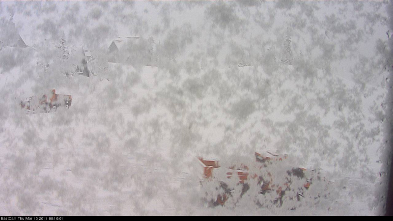
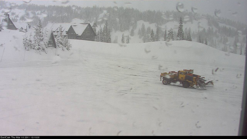
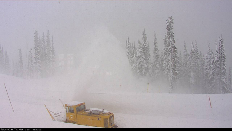
The road up to Paradise remained closed to the public all day though, so the 200" celebration party must have been a lonely one. Some webcam images of snow plowing operations today at Paradise:
[size=small](Edited to add photos and last 2 hours of data.)[/size]
Northwest Weather and Avalanche Center
Paradise, Mt Rainier National Park, Washington
MM/DD Hour Temp RH Wind Wind Wind Hour Total 24 Hr Total Solar
PST F % Avg Max Dir Prec. Prec. Snow Snow W/m2
5550' 5550' 5500' 5500' 5500' 5550' 5550' 5550' 5550' 5500'
3 9 1500 33 100 21 31 272 .04 .09 5 187 115
3 9 1600 33 100 18 24 271 .06 .15 5 187 63
3 9 1700 33 100 14 22 267 .06 .21 5 187 26
3 9 1800 33 100 13 20 265 .04 .25 4 186 10
3 9 1900 33 100 12 18 267 .05 .3 6 186 0
3 9 2000 33 100 8 14 275 0 .3 5 187 0
3 9 2100 33 100 4 10 301 .06 .36 7 186 0
3 9 2200 33 100 10 18 295 .08 .44 7 187 0
3 9 2300 33 100 12 19 289 .12 .56 8 190 0
3 10 0 32 100 16 27 283 .11 .67 10 192 0
3 10 100 32 100 17 28 280 .06 .73 10 194 0
3 10 200 32 100 14 23 275 .11 .84 11 194 0
3 10 300 32 100 12 18 277 .12 .96 12 197 0
3 10 400 32 100 14 23 275 .11 1.07 14 199 0
3 10 500 31 100 16 24 271 .09 1.16 14 201 0
3 10 600 28 100 18 28 271 .1 1.26 17 202 0
3 10 700 27 100 24 36 277 .06 1.32 19 203 1
3 10 800 27 100 16 25 279 .03 1.35 19 203 21
3 10 900 28 100 13 21 263 .05 1.4 19 203 71
3 10 1000 30 99 14 22 273 .01 1.41 19 202 143
3 10 1100 31 99 17 26 273 0 1.41 19 201 314
3 10 1200 32 98 19 28 275 0 1.41 1 196 462
3 10 1300 30 99 15 26 263 0 1.41 1 196 368
3 10 1400 29 100 21 36 271 .02 1.34 1 195 240
3 10 1500 28 100 20 33 263 .05 1.33 1 196 86
3 10 1600 27 100 23 40 269 .05 1.38 2 196 65
Northwest Weather and Avalanche Center
Mt Baker Ski Area, Washington
Wind sensors unheated and may rime
Precip gage appears to be under-recording 2-27-2011
MM/DD Hour Temp Temp RH RH Wind Wind Wind Wind Hour Total 24 Hr Total
PST F F % % Min Avg Max Dir Prec. Prec. Snow Snow
5000' 4210' 5000' 4210' 5000' 5000' 5000' 5000' 4210' 4210' 4210' 4210'
3 9 1500 31 33 100 100 11 19 34 249 0.11 0.26 1 190
3 9 1600 31 33 100 100 11 21 31 190 0.10 0.36 1 191
3 9 1700 30 33 100 100 13 24 42 193 0.08 0.44 2 192
3 9 1800 30 33 100 100 5 21 40 202 0.05 0.49 2 192
3 9 1900 30 33 100 100 12 27 51 181 0.10 0.59 2 191
3 9 2000 29 33 100 100 8 22 44 252 0.05 0.64 3 192
3 9 2100 29 32 100 100 4 10 24 149 0.02 0.66 3 192
3 9 2200 29 32 100 100 1 10 20 188 0.01 0.67 3 192
3 9 2300 28 32 100 98 1 5 15 111 0.00 0.67 3 192
3 10 0 28 31 100 100 0 5 15 155 0.13 0.80 4 191
3 10 100 28 31 100 100 3 14 31 175 0.11 0.91 7 194
3 10 200 29 32 100 100 12 23 32 195 0.07 0.98 7 194
3 10 300 29 32 100 100 18 27 37 168 0.08 1.06 8 195
3 10 400 29 32 100 100 20 36 55 176 0.10 1.16 9 195
3 10 500 29 32 100 100 11 35 58 195 0.06 1.22 9 196
3 10 600 28 31 100 100 12 26 49 218 0.07 1.29 10 197
3 10 700 27 30 100 100 16 35 64 153 0.02 1.31 1 198
3 10 800 27 31 100 100 16 34 49 186 0.03 1.34 1 198
3 10 900 28 31 100 100 9 28 44 187 0.03 1.37 1 198
3 10 1000 28 31 100 100 16 31 44 184 0.05 1.42 2 198
3 10 1100 28 31 100 100 6 22 37 178 0.06 1.48 2 198
3 10 1200 29 32 100 99 14 30 49 192 0.06 1.54 3 199
3 10 1300 28 32 100 98 11 26 51 225 0.03 1.57 3 199
3 10 1400 29 32 100 98 8 27 52 236 0.14 1.45 3 199
3 10 1500 28 31 100 99 3 16 38 181 0.05 1.40 4 199
3 10 1600 28 31 100 100 6 18 39 227 0.08 1.48 5 200
Although Baker has now reached 200" also, and retaken the lead after settlement at Paradise pushed it back under 200" . . .
One of 5 sites is usually the seasonal snowdepth leader for the Cascade Range: either Paradise, Chinook Pass, Baker Ski Area, Timberline Lodge, or Lassen Peak. The Chinook Pass site often has depths that match or slightly exceed Paradise, but it has been out of phone/radio communication since November 20, 2010 (it was also offline all of last season from November 21, 2009 to July 14, 2010 -- hard to keep that site in touch). Timberline Lodge is far behind this year at about 150", while Lassen Peak is close, reaching 184" on March 7.
Since weather record-keeping began at Paradise in 1916, the snow depth has reached 200" at some point during nearly half of the 92 seasons with data, most recently in 2008. The median seasonal maximum is 197", with the maximum depth typically reached on March 31. Only about 1/5 of the seasons (18) has the Paradise snow depth reached 240", while only 3 seasons have broken 300", most recently in 1972. The maximum snow depth at Paradise of 367" was on March 10, 1956. The lowest seasonal maximum was a paltry 95" on April 15, 2005 -- the only season where the depth has not reached 100" at Paradise.
The road up to Paradise remained closed to the public all day though, so the 200" celebration party must have been a lonely one. Some webcam images of snow plowing operations today at Paradise:
[size=small](Edited to add photos and last 2 hours of data.)[/size]
Please Log in or Create an account to join the conversation.
- Jason_H.
- [Jason_H.]
-
- Offline
- Senior Member
-

Less
More
- Posts: 276
- Thank you received: 0
10 Mar 2011 15:20 #198748
by Jason_H.
Replied by Jason_H. on topic Re: Mount Rainier Paradise reaches 200" snow depth
Wow, 367 inches in '56 is a ton of snow. That's over 30 feet! Cool. Bet that was a great spring season.
What's the highest recorded seasonal snow depth ever recorded anywhere?
What's the highest recorded seasonal snow depth ever recorded anywhere?
Please Log in or Create an account to join the conversation.
- Andrew Gorohoff
- [Gorohoff]
-
- Offline
- New Member
-

Less
More
- Posts: 37
- Thank you received: 0
10 Mar 2011 16:10 - 10 Mar 2011 16:15 #198749
by Andrew Gorohoff
Replied by Andrew Gorohoff on topic Re: Mount Rainier Paradise reaches 200" snow depth
per Wikipedia en.wikipedia.org/wiki/Snow
The world record for the highest seasonal total snowfall was measured in the United States at Mount Baker Ski Area, outside of the town Bellingham, Washington during the 1998–1999 season. Mount Baker received 2,896 cm (1,140 in) of snow, thus surpassing the previous record holder, Mount Rainier, Washington, which during the 1971–1972 season received 2,850 cm (1,120 in) of snow.
Edit: just noticed the "in the United States" part...thought this was "anywhere".
Please Log in or Create an account to join the conversation.
- Pete A
- [Bud]
-
- Offline
- Senior Member
-
Less
More
- Posts: 431
- Thank you received: 0
10 Mar 2011 16:13 #198750
by Pete A
Replied by Pete A on topic Re: Mount Rainier Paradise reaches 200" snow depth
...but what did Baker's record snowfall equate to as actual snowpack on the ground?
Please Log in or Create an account to join the conversation.
- Amar Andalkar
- [andalkar]
-
Topic Author
- Offline
- Premium Member
-
Less
More
- Posts: 635
- Thank you received: 0
10 Mar 2011 16:16 - 10 Mar 2011 16:45 #198751
by Amar Andalkar
Replied by Amar Andalkar on topic Re: Mount Rainier Paradise reaches 200" snow depth
The greatest seasonal snow depth ever measured at an official weather station is 466" (1182 cm) near the summit of
Mount Ibuki
, a 4500 ft mountain near the west coast of Honshu in Japan, on February 14, 1927.

The North American record for seasonal snow depth is 451" at Tamarack, CA, at 6900 ft along Hwy 4 west of Ebbets Pass in the Sierra Nevada, on March 11, 1911. During January of that year, 390" of snowfall was recorded, which is a world record for a single calendar month (Paradise received 363" during January 1925, the biggest month in the Cascades).
A great book with fairly accurate info about snowfall and snow depth records is Extreme Weather: A Guide and Record Book by Christopher Burt (accurate info is very hard to find on this subject, with much erroneous info in most sources). You can read parts of the book on Google Books, see chapter 3 for snow info . He also writes an interesting blog on Wunderground, Weather Historian .
The maximum snowdepth at Baker Ski Area during the world "record" snowfall season of 1998-99 was 318" on March 30, 1999. I put "record" in quotes because the 1140" during the 1998-99 season is only a record for a single season (July 1-June 30 in the northern hemisphere). The maximum snowfall during any one-year period is still held by Paradise, with 1224" from February 19, 1971 to February 18, 1972. However, that is not an official record recognized by the National Climate Extremes Committee.
The North American record for seasonal snow depth is 451" at Tamarack, CA, at 6900 ft along Hwy 4 west of Ebbets Pass in the Sierra Nevada, on March 11, 1911. During January of that year, 390" of snowfall was recorded, which is a world record for a single calendar month (Paradise received 363" during January 1925, the biggest month in the Cascades).
A great book with fairly accurate info about snowfall and snow depth records is Extreme Weather: A Guide and Record Book by Christopher Burt (accurate info is very hard to find on this subject, with much erroneous info in most sources). You can read parts of the book on Google Books, see chapter 3 for snow info . He also writes an interesting blog on Wunderground, Weather Historian .
...but what did Baker's record snowfall equate to as actual snowpack on the ground?
The maximum snowdepth at Baker Ski Area during the world "record" snowfall season of 1998-99 was 318" on March 30, 1999. I put "record" in quotes because the 1140" during the 1998-99 season is only a record for a single season (July 1-June 30 in the northern hemisphere). The maximum snowfall during any one-year period is still held by Paradise, with 1224" from February 19, 1971 to February 18, 1972. However, that is not an official record recognized by the National Climate Extremes Committee.
Please Log in or Create an account to join the conversation.
- Andrew Carey
- [acarey]
-

- Offline
- Elite Member
-

Less
More
- Posts: 912
- Thank you received: 0
10 Mar 2011 18:49 #198754
by Andrew Carey
Replied by Andrew Carey on topic Re: Mount Rainier Paradise reaches 200" snow depth
I remember when Regine & I made a trip to Paradise (prob. 1999) and the walls around the parking lot were shear and more than 15 ft high, and the snow was up to the dormer windows on the Inn. Once we scaled the walls we didn't go very far, because on our then fat (now skinny) telemark skis, we just wallowed in the deep powder; also remember one season when the upper road had so much snow that it seemed cornices would bridge the road.
Please Log in or Create an account to join the conversation.
- markharf
- [markharf]
-
- Offline
- Senior Member
-
Less
More
- Posts: 339
- Thank you received: 3
10 Mar 2011 21:36 - 10 Mar 2011 21:47 #198759
by markharf
Replied by markharf on topic Re: Mount Rainier Paradise reaches 200" snow depth
Amar sed: "....settlement at Paradise pushed it back under 200" "
I'm predisposed to favor Mt. Baker (where the telemetry snow depth now reads 206 inches, but where the ski area snowstake at 5000 feet is currently over 230"), but in fairness I don't think that what you're seeing at Paradise was due to natural settlement. Look at the readings around noon today: you'll see that the snow depth plummeted 5 inches abruptly just as the 24 hour gauge was re-set. That's not coincidental.
I've always been fascinated by the disparities between measurements at official stations and measurements elsewhere. A couple of thousand feet higher on Mt. Baker, snowfalls and snow depths are far deeper than they are at the official measuring station at the ski area. At the summit, however, depths have already begun to lessen (as far as I can tell). Same is presumably true on Mt. Rainier: summit snowfalls are typically not as deep as they are at some unspecified moderate elevation....or so I presume, presumptuously.
At any rate, the "World Record (tm)" is just the greatest snowfall measured according to various specific parameters; it certainly snows far more at other spots which lack, for obvious reasons, weather stations. I wouldn't be surprised if the actual deepest snows in the world are somewhere further north in the Coast Range, or perhaps along the Gulf of Alaska, or even somewhere in the southern Andes in Chile. And I don't know Japan, but it sounds like there might be some contenders there as well.
I'd be interested in hearing any speculation even marginally more informed than my own.
Mark
Please Log in or Create an account to join the conversation.
- Amar Andalkar
- [andalkar]
-
Topic Author
- Offline
- Premium Member
-
Less
More
- Posts: 635
- Thank you received: 0
10 Mar 2011 22:09 #198763
by Amar Andalkar
Of course that 5" drop looks suspicious, I was even thinking of phrasing that sentence as "after settlement (or disturbance?) at Paradise". But then I looked carefully at many factors: it had stopped snowing just before 10am, the temps also hit 32 during that 11am-noon hour, and the solar radiation was at a maximum (baking under the cloud layer), so it could have been non-human-related. The early morning snowfall that fell between 5am and 7am was very light and fluffy, so it could have rapidly settled with some solar cooking. The freshly plowed parking lot melted out very quickly after 11am, and by 12:50pm looked like this:
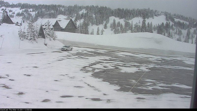
Then it started started to snow again just minutes before 1pm, quickly hiding the bare pavement. Based on the evidence from multiple sources (temperature, solar radiation, and webcam), I'm inclined to consider the settlement as likely natural, and not due to the ranger who cleaned off the 24-hour snow depth board.
Replied by Amar Andalkar on topic Re: Mount Rainier Paradise reaches 200" snow depth
Amar sed: "....settlement at Paradise pushed it back under 200" "
I'm predisposed to favor Mt. Baker (where the telemetry snow depth now reads 206 inches, but where the ski area snowstake at 5000 feet is currently over 230"), but in fairness I don't think that what you're seeing at Paradise was due to natural settlement. Look at the readings around noon today: you'll see that the snow depth plummeted 5 inches abruptly just as the 24 hour gauge was re-set. That's not coincidental.
Of course that 5" drop looks suspicious, I was even thinking of phrasing that sentence as "after settlement (or disturbance?) at Paradise". But then I looked carefully at many factors: it had stopped snowing just before 10am, the temps also hit 32 during that 11am-noon hour, and the solar radiation was at a maximum (baking under the cloud layer), so it could have been non-human-related. The early morning snowfall that fell between 5am and 7am was very light and fluffy, so it could have rapidly settled with some solar cooking. The freshly plowed parking lot melted out very quickly after 11am, and by 12:50pm looked like this:
Then it started started to snow again just minutes before 1pm, quickly hiding the bare pavement. Based on the evidence from multiple sources (temperature, solar radiation, and webcam), I'm inclined to consider the settlement as likely natural, and not due to the ranger who cleaned off the 24-hour snow depth board.
Please Log in or Create an account to join the conversation.
- Amar Andalkar
- [andalkar]
-
Topic Author
- Offline
- Premium Member
-
Less
More
- Posts: 635
- Thank you received: 0
10 Mar 2011 23:19 #198767
by Amar Andalkar
True, the disparities are interesting. Snowfall increases substantially above 4000 ft in the Cascades, reaching a maximum at about the 7000-9000 ft elevations, and decreasing above that due to the colder drier atmosphere. However, snowfall and snowdepth measurement sites generally must be located below treeline to avoid the effects of wind, which can cause a +/- 100% (zero to double) spatial variation in snow depths above treeline.
But I've always been more surprised by the lack of disparity between snow depth measurement sites located hundreds of miles apart along the Cascade Range. The Paradise and Baker Ski Area sites often track each other in eerie similarity (as today, hitting 200" only hours apart), with depths within a few % of each other for months at a time. Their average values reflect this similarity too throughout the season, until the Baker site's lower elevation melts it out much more rapidly during the spring.
During many winters, the snowdepth at Timberline Lodge on Mount Hood tracks just 5-10% behind the Paradise and Baker sites throughout the season too. The Baker site is about 130 miles north of Paradise, while Timberline is about 105 miles south. All three sites are located in open subalpine forest about 1000 ft below treeline, and are in zones of enhanced snowfall near large isolated stratovolcanoes, with Paradise and Timberline both directly on the south flank of their volcanoes, and Baker Ski Area within a convergence-zone-like area of enhanced snowfall extending ENE from Baker's cone. The fact that sites which are hundreds of miles apart track each other so closely in snowdepth is strong evidence that the sites are very well-located and are highly representative of the snowpack over a wide area.
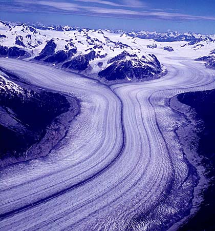
I think the scientific consensus for the location in the world with the greatest snowfall and greatest average snowdepths is somewhere in the coastal ranges of south-central and SE Alaska, with locations in the eastern Chugach, Saint Elias, and Coast Mountains in contention for the top spot. The other possible contenders are the southern Andes of Chile and the Southern Alps of New Zealand, but these are probably vying for the southern hemisphere title and not likely to surpass coastal AK.
However, the greatest recorded snowdepths at measurement sites DO NOT occur at the sites which have the maximum average annual snowfalls. They occur at sites which have freakishly huge sustained snowstorms, but too much in-season variability to ever challenge for the full-year snowfall records. Thus we have sites in the Sierra Nevada and the west coast of Honshu, Japan, holding the records for snowdepth and one-month snowfall -- these places are the most likely to get 15-20 ft of snowfall in a single storm cycle, which is the kind of snowfall rate you need to build snowdepths over 400". The Sierra gets the huge snows when cutoff lows dive south just off the Pacific Coast and park themselves west of northern CA, while Honshu's snowfall is due entirely to ocean-effect snowfall caused by arctic outflow pouring SE from Siberian high pressure, crossing the warm water of the Sea of Japan, and slamming into the mountainous west coast of the island. These patterns can produce monthly snowfalls over 300", but don't stay in place long enough over a full season to reach annual snowfalls over 1000".
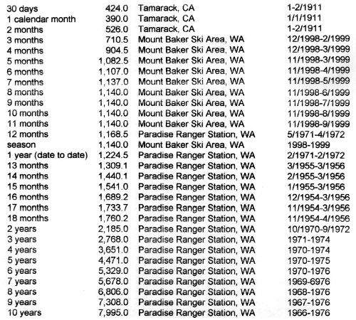
Paradise and Baker Ski Area remain the only sites worldwide to have recorded over 1000" of snowfall in a single season, with Paradise breaking that mark 5 different times. All of the time-period snowfall records for periods 3 months or longer are held by those two sites. Here's part of a collection snowfall records compiled and sent to me by Fred Richardson:
Replied by Amar Andalkar on topic Re: Mount Rainier Paradise reaches 200" snow depth
I've always been fascinated by the disparities between measurements at official stations and measurements elsewhere. A couple of thousand feet higher on Mt. Baker, snowfalls and snow depths are far deeper than they are at the official measuring station at the ski area. At the summit, however, depths have already begun to lessen (as far as I can tell). Same is presumably true on Mt. Rainier: summit snowfalls are typically not as deep as they are at some unspecified moderate elevation....or so I presume, presumptuously.
True, the disparities are interesting. Snowfall increases substantially above 4000 ft in the Cascades, reaching a maximum at about the 7000-9000 ft elevations, and decreasing above that due to the colder drier atmosphere. However, snowfall and snowdepth measurement sites generally must be located below treeline to avoid the effects of wind, which can cause a +/- 100% (zero to double) spatial variation in snow depths above treeline.
But I've always been more surprised by the lack of disparity between snow depth measurement sites located hundreds of miles apart along the Cascade Range. The Paradise and Baker Ski Area sites often track each other in eerie similarity (as today, hitting 200" only hours apart), with depths within a few % of each other for months at a time. Their average values reflect this similarity too throughout the season, until the Baker site's lower elevation melts it out much more rapidly during the spring.
During many winters, the snowdepth at Timberline Lodge on Mount Hood tracks just 5-10% behind the Paradise and Baker sites throughout the season too. The Baker site is about 130 miles north of Paradise, while Timberline is about 105 miles south. All three sites are located in open subalpine forest about 1000 ft below treeline, and are in zones of enhanced snowfall near large isolated stratovolcanoes, with Paradise and Timberline both directly on the south flank of their volcanoes, and Baker Ski Area within a convergence-zone-like area of enhanced snowfall extending ENE from Baker's cone. The fact that sites which are hundreds of miles apart track each other so closely in snowdepth is strong evidence that the sites are very well-located and are highly representative of the snowpack over a wide area.
At any rate, the "World Record (tm)" is just the greatest snowfall measured according to various specific parameters; it certainly snows far more at other spots which lack, for obvious reasons, weather stations. I wouldn't be surprised if the actual deepest snows in the world are somewhere further north in the Coast Range, or perhaps along the Gulf of Alaska, or even somewhere in the southern Andes in Chile. And I don't know Japan, but it sounds like there might be some contenders there as well.
I think the scientific consensus for the location in the world with the greatest snowfall and greatest average snowdepths is somewhere in the coastal ranges of south-central and SE Alaska, with locations in the eastern Chugach, Saint Elias, and Coast Mountains in contention for the top spot. The other possible contenders are the southern Andes of Chile and the Southern Alps of New Zealand, but these are probably vying for the southern hemisphere title and not likely to surpass coastal AK.
However, the greatest recorded snowdepths at measurement sites DO NOT occur at the sites which have the maximum average annual snowfalls. They occur at sites which have freakishly huge sustained snowstorms, but too much in-season variability to ever challenge for the full-year snowfall records. Thus we have sites in the Sierra Nevada and the west coast of Honshu, Japan, holding the records for snowdepth and one-month snowfall -- these places are the most likely to get 15-20 ft of snowfall in a single storm cycle, which is the kind of snowfall rate you need to build snowdepths over 400". The Sierra gets the huge snows when cutoff lows dive south just off the Pacific Coast and park themselves west of northern CA, while Honshu's snowfall is due entirely to ocean-effect snowfall caused by arctic outflow pouring SE from Siberian high pressure, crossing the warm water of the Sea of Japan, and slamming into the mountainous west coast of the island. These patterns can produce monthly snowfalls over 300", but don't stay in place long enough over a full season to reach annual snowfalls over 1000".
Paradise and Baker Ski Area remain the only sites worldwide to have recorded over 1000" of snowfall in a single season, with Paradise breaking that mark 5 different times. All of the time-period snowfall records for periods 3 months or longer are held by those two sites. Here's part of a collection snowfall records compiled and sent to me by Fred Richardson:
Please Log in or Create an account to join the conversation.
- Robert Connor
- [robert]
-
- Offline
- Junior Member
-

Less
More
- Posts: 123
- Thank you received: 0
11 Mar 2011 12:29 #198783
by Robert Connor
Replied by Robert Connor on topic Re: Mount Rainier Paradise reaches 200" snow depth
Will there ever be a technical or scientific question to which Amar doesn't have the correct answer supported by reams of backup data? Thank you Amar. It is like TAY has our own private research department.
Please Log in or Create an account to join the conversation.
- Jason_H.
- [Jason_H.]
-
- Offline
- Senior Member
-
Less
More
- Posts: 276
- Thank you received: 0
11 Mar 2011 13:49 #198788
by Jason_H.
Replied by Jason_H. on topic Re: Mount Rainier Paradise reaches 200" snow depth
When I spoke to you about this before Amar, you mentioned that the area around the Blue Glacier on Mount Olympus contends with other regions of the World that get potentially more snow than paradise. How would you guess this compares to places in SE Alaska?
Please Log in or Create an account to join the conversation.
- garyabrill
- [garyabrill]
-
- Offline
- Senior Member
-
Less
More
- Posts: 464
- Thank you received: 0
11 Mar 2011 15:43 - 11 Mar 2011 16:38 #198793
by garyabrill
Replied by garyabrill on topic Re: Mount Rainier Paradise reaches 200" snow depth
Whoa, now. How about January 1990 at Mt. Baker...actually a 3-1/2 week period ending around February 5 (approximate). Baker received just under 500" in that 3-1/2 week period (I don't recall exactly but something like mid 480's as reported by the ski area). Stevens got 330" in the same period. When the freezing level rose to 4500' briefly towards the end of that period the biggest slides in the Cascades since perhaps 1972 came down - notably the Phantom slide path on Snoqualmie, the slide path that crossed 20 beneath Ruby Mtn, and to my knowledge the biggest slide I know of in the Cascades in Grouse Creek - I'd guess that one took out 100 acres of old growth and reached an astonishing 400' up the opposite side of a narrow gully leaving an impressive trimline. The largest fracture I saw from Mt. Herman around February 5th was on the Mazama Glacier of Baker and having skied the Mazama once (for scale) I estimated the crown at 20-25 feet - probably about the same size as the Grouse Creek crown. There was a crown measured at 13' near the Blueberry ropetow. Other than those 3-1/2 weeks 1990 was a poor snow year.
As far as where the greatest snows are my vote would be for Mt. Silverthrone in the BC coast mountains where the Klinaklini Glacier descends 20+ miles, still extending to just 500-800' above sea level. I flew over the snout of the Klinaklini on a sight seeing daytrip two years ago. Five miles above the snout the glacier (maybe at 5000') still rises nearly to it's trimlines. There are several mile wide feeder glaciers. Apparently in the last ice age the apex of glaciation was at the latitude of Tweedsmuir Park with glaciers flowing both ways from that point (I don't remember where I got that trivia) so it would make sense that would be the zone of heaviest snowfall.
In 1996 it looked to me that the Palisades in CA had around 600" (50') of snow on the ground in mid to late April. That was a guess based on the fact that numerous 50' polished nunataks that one passes on the trail into the northern portion of the Palisade Glacier were essentially buried by the huge snowpack. I should add that was around the 11000' level.
Please Log in or Create an account to join the conversation.
- philfort
- [philfort]
-
- Offline
- Senior Member
-
Less
More
- Posts: 259
- Thank you received: 0
12 Mar 2011 16:13 #198807
by philfort
The sno-tel site on the SW side of the Olympics shows a 196" snow depth right now, roughly what Paradise has:
www.wcc.nrcs.usda.gov/nwcc/sntl-data0000...1107&days=7&state=wa
Replied by philfort on topic Re: Mount Rainier Paradise reaches 200" snow depth
When I spoke to you about this before Amar, you mentioned that the area around the Blue Glacier on Mount Olympus contends with other regions of the World that get potentially more snow than paradise. How would you guess this compares to places in SE Alaska?
The sno-tel site on the SW side of the Olympics shows a 196" snow depth right now, roughly what Paradise has:
www.wcc.nrcs.usda.gov/nwcc/sntl-data0000...1107&days=7&state=wa
Please Log in or Create an account to join the conversation.
- garyabrill
- [garyabrill]
-
- Offline
- Senior Member
-
Less
More
- Posts: 464
- Thank you received: 0
12 Mar 2011 19:26 #198811
by garyabrill
Replied by garyabrill on topic Re: Mount Rainier Paradise reaches 200" snow depth
I got my information regarding Mt. Baker by a phone call in 1990 to NWAC and have had it since. It is possible it remains in their archives.
Please Log in or Create an account to join the conversation.
- Amar Andalkar
- [andalkar]
-
Topic Author
- Offline
- Premium Member
-
Less
More
- Posts: 635
- Thank you received: 0
13 Mar 2011 23:21 #198857
by Amar Andalkar
Actually, if you look at the hourly data (www.wcc.nrcs.usda.gov/nwcc/sntl-datarpt....1107&days=7&state=wa), you can see that the 196" value is an error -- the snowdepth jumps from 180" to 196" at 1400 on March 10, and then stays there afterwards. So it looks like 196" is the height that the ultrasonic snowdepth sensor is mounted above the ground, and it gives that value if the sensor is obstructed. However, given the continued snowfall the last few days, the real snowdepth has probably exceeded 196" by now at that site, and the sensor is probably buried and will provide no useful data for the rest of the season until the snowpack melts down in early summer.
It's a shame that when the NRCS finally added snowdepth sensors to all of their SNOTEL sites a couple of years ago (previously most SNOTEL sites had only temperature, precip, and snow-water equivalent), they mounted many of the snowdepth sensors far too low, at roughly 200" or 240" above the ground where they would easily get buried by the snowpack in any fat snowpack year. I can't believe that they didn't realize that the sensors needed to be mounted at least 300" high (or even 360" for some sites) in order to be safely above the level of an above-average snowpack. The one at Swift Creek SNOTEL at 4400 ft on the south side of Mt St Helens gets buried like that in each good snow year, which is really disappointing since this is an exceptionally high-snowfall site which often approaches or exceeds Paradise or Baker Ski Area in its snowdepth, and also located right near a major ski mountaineering route (Worm Flows). They need to raise the height of the snowdepth sensors at these high-snowfall sites to avoid this foolish loss of good snowdepth data, especially in the huge years when it is most useful and interesting.
It would be interesting to find the daily records from that period -- 480+" would be amazing! There is NWAC telemetry data for Mount Baker Ski Area from the 1989-90 season, which I looked through today, but it has no 24 hour snowdepth or total snowdepth data. Anyway, it looks like the period of interest runs from January 22 to February 17, 1990 (a period of 27 days), based on the daily data from Paradise for those months from the official archives at the National Climatic Data Center:
The total snowfall during the five days of missing data (January 27-31) was about 72", which I calculated based on NPS annual snowfall totals and which makes sense given that the snowdepth increases by 44" during that time. So Paradise received 52" (Jan 22-26) + about 72" (Jan 27-31) + 214" (Feb 1-17) = about 338" during the 27 day period. Based on that already-huge number at a site which is typically comparable in snowfall, it would be highly unlikely that Mount Baker Ski Area got 480+" during the same period -- but it certainly could have done so.
However, since the snowfall is split among two calendar months, the Baker snowfall would not be enough to exceed the calendar month record of 390" (since only about 300" of the 480" would probably be in February). When Mount Baker Ski Area got 303" in February of 1999 (during the record 1140" season), it was widely reported to be a new single-month record for that site, so Feb 1990 probably got less than that unless the 1999 news reports were erroneous.
Replied by Amar Andalkar on topic Re: Mount Rainier Paradise reaches 200" snow depth
The sno-tel site on the SW side of the Olympics shows a 196" snow depth right now, roughly what Paradise has:
www.wcc.nrcs.usda.gov/nwcc/sntl-data0000...1107&days=7&state=wa
Actually, if you look at the hourly data (www.wcc.nrcs.usda.gov/nwcc/sntl-datarpt....1107&days=7&state=wa), you can see that the 196" value is an error -- the snowdepth jumps from 180" to 196" at 1400 on March 10, and then stays there afterwards. So it looks like 196" is the height that the ultrasonic snowdepth sensor is mounted above the ground, and it gives that value if the sensor is obstructed. However, given the continued snowfall the last few days, the real snowdepth has probably exceeded 196" by now at that site, and the sensor is probably buried and will provide no useful data for the rest of the season until the snowpack melts down in early summer.
It's a shame that when the NRCS finally added snowdepth sensors to all of their SNOTEL sites a couple of years ago (previously most SNOTEL sites had only temperature, precip, and snow-water equivalent), they mounted many of the snowdepth sensors far too low, at roughly 200" or 240" above the ground where they would easily get buried by the snowpack in any fat snowpack year. I can't believe that they didn't realize that the sensors needed to be mounted at least 300" high (or even 360" for some sites) in order to be safely above the level of an above-average snowpack. The one at Swift Creek SNOTEL at 4400 ft on the south side of Mt St Helens gets buried like that in each good snow year, which is really disappointing since this is an exceptionally high-snowfall site which often approaches or exceeds Paradise or Baker Ski Area in its snowdepth, and also located right near a major ski mountaineering route (Worm Flows). They need to raise the height of the snowdepth sensors at these high-snowfall sites to avoid this foolish loss of good snowdepth data, especially in the huge years when it is most useful and interesting.
Whoa, now. How about January 1990 at Mt. Baker...actually a 3-1/2 week period ending around February 5 (approximate). Baker received just under 500" in that 3-1/2 week period (I don't recall exactly but something like mid 480's as reported by the ski area). Stevens got 330" in the same period. When the freezing level rose to 4500' briefly towards the end of that period the biggest slides in the Cascades since perhaps 1972 came down - notably the Phantom slide path on Snoqualmie, the slide path that crossed 20 beneath Ruby Mtn, and to my knowledge the biggest slide I know of in the Cascades in Grouse Creek - I'd guess that one took out 100 acres of old growth and reached an astonishing 400' up the opposite side of a narrow gully leaving an impressive trimline. The largest fracture I saw from Mt. Herman around February 5th was on the Mazama Glacier of Baker and having skied the Mazama once (for scale) I estimated the crown at 20-25 feet - probably about the same size as the Grouse Creek crown. There was a crown measured at 13' near the Blueberry ropetow. Other than those 3-1/2 weeks 1990 was a poor snow year.
Amar, the 1990 period of snowfall at Baker would break the record for a one month and 30 day period if it could be confirmed, i.e. if the records still exist. Since there was no telemetry at the time NWAC would have used the ski resorts daily weather station information.
It would be interesting to find the daily records from that period -- 480+" would be amazing! There is NWAC telemetry data for Mount Baker Ski Area from the 1989-90 season, which I looked through today, but it has no 24 hour snowdepth or total snowdepth data. Anyway, it looks like the period of interest runs from January 22 to February 17, 1990 (a period of 27 days), based on the daily data from Paradise for those months from the official archives at the National Climatic Data Center:
The total snowfall during the five days of missing data (January 27-31) was about 72", which I calculated based on NPS annual snowfall totals and which makes sense given that the snowdepth increases by 44" during that time. So Paradise received 52" (Jan 22-26) + about 72" (Jan 27-31) + 214" (Feb 1-17) = about 338" during the 27 day period. Based on that already-huge number at a site which is typically comparable in snowfall, it would be highly unlikely that Mount Baker Ski Area got 480+" during the same period -- but it certainly could have done so.
However, since the snowfall is split among two calendar months, the Baker snowfall would not be enough to exceed the calendar month record of 390" (since only about 300" of the 480" would probably be in February). When Mount Baker Ski Area got 303" in February of 1999 (during the record 1140" season), it was widely reported to be a new single-month record for that site, so Feb 1990 probably got less than that unless the 1999 news reports were erroneous.
Please Log in or Create an account to join the conversation.
- Amar Andalkar
- [andalkar]
-
Topic Author
- Offline
- Premium Member
-
Less
More
- Posts: 635
- Thank you received: 0
14 Mar 2011 00:31 #198858
by Amar Andalkar
Olympus definitely gets more snowfall than anyplace in the Cascades, since the average annual precip on Blue Glacier is over 200" (something like 240" at the 7000 ft level if I remember correctly -- don't recall where I read that though). The annual precip at SNOTEL sites on the south sides of Mt St Helens and Mt Baker is about 170", and those are by far the wettest measurement sites in the Cascades. There have been snowdepth measurements taken on Blue Glacier and Snowdome by UW scientists since about 1958, but that data appears not to be available online, and in any case, snowdepth on glaciers is subject to significant enhancement from wind-loading, compared to a neutral site like a subalpine clearing in open forest. So I don't know if there is a way to make a direct comparison.
Based on annual precip, it seems certain that areas in SE Alaska have greater snowfall than the Olympics -- there are areas of SE Alaska which get over 200" of annual precip at sea level (Little Port Walter averages 228"), with amounts likely exceeding 300" at a few thousand feet elevation in favored locations. Given the more northerly latitude and the greater precip, snowfall and snowdepths must be much greater there than in the Olympics.
I have no idea if areas in the central part of the BC Coast Mountains (i.e. the Waddington / Silverthrone area) receive comparable precip and snowfall to the most favored areas of SE Alaska or not. But Henderson Lake near sea level on Vancouver Island is the rainiest measurement site in North America, with average annual precip of 256", and so the highest peaks on the island in Strathcona Park presumably receive huge snowfalls. No measurement sites are located in the highest snowfall areas though.
But the central BC Coast Mountains are somewhat in the rainshadow of Vancouver Island, and I have not seen any good data for either precip or snowpack in that area, and do not think that any exists. The three BC snow telemetry sites in the area (bcrfc.env.gov.bc.ca/data/asp/realtime/, sites 3C08P, 3A22P, 3A24P) are located in really low snowfall spots, I mean these places get an average snow-water equivalent of 12-30", corresponding to meager snow depths of 30-75". Obviously, seasonal snow depths in more favored locations near Waddington or Silverthrone must be several times greater than that, to support the large glaciers descending to nearly sea level.
Replied by Amar Andalkar on topic Re: Mount Rainier Paradise reaches 200" snow depth
When I spoke to you about this before Amar, you mentioned that the area around the Blue Glacier on Mount Olympus contends with other regions of the World that get potentially more snow than paradise. How would you guess this compares to places in SE Alaska?
Olympus definitely gets more snowfall than anyplace in the Cascades, since the average annual precip on Blue Glacier is over 200" (something like 240" at the 7000 ft level if I remember correctly -- don't recall where I read that though). The annual precip at SNOTEL sites on the south sides of Mt St Helens and Mt Baker is about 170", and those are by far the wettest measurement sites in the Cascades. There have been snowdepth measurements taken on Blue Glacier and Snowdome by UW scientists since about 1958, but that data appears not to be available online, and in any case, snowdepth on glaciers is subject to significant enhancement from wind-loading, compared to a neutral site like a subalpine clearing in open forest. So I don't know if there is a way to make a direct comparison.
Based on annual precip, it seems certain that areas in SE Alaska have greater snowfall than the Olympics -- there are areas of SE Alaska which get over 200" of annual precip at sea level (Little Port Walter averages 228"), with amounts likely exceeding 300" at a few thousand feet elevation in favored locations. Given the more northerly latitude and the greater precip, snowfall and snowdepths must be much greater there than in the Olympics.
As far as where the greatest snows are my vote would be for Mt. Silverthrone in the BC coast mountains where the Klinaklini Glacier descends 20+ miles, still extending to just 500-800' above sea level. I flew over the snout of the Klinaklini on a sight seeing daytrip two years ago. Five miles above the snout the glacier (maybe at 5000') still rises nearly to it's trimlines. There are several mile wide feeder glaciers. Apparently in the last ice age the apex of glaciation was at the latitude of Tweedsmuir Park with glaciers flowing both ways from that point (I don't remember where I got that trivia) so it would make sense that would be the zone of heaviest snowfall.
I have no idea if areas in the central part of the BC Coast Mountains (i.e. the Waddington / Silverthrone area) receive comparable precip and snowfall to the most favored areas of SE Alaska or not. But Henderson Lake near sea level on Vancouver Island is the rainiest measurement site in North America, with average annual precip of 256", and so the highest peaks on the island in Strathcona Park presumably receive huge snowfalls. No measurement sites are located in the highest snowfall areas though.
But the central BC Coast Mountains are somewhat in the rainshadow of Vancouver Island, and I have not seen any good data for either precip or snowpack in that area, and do not think that any exists. The three BC snow telemetry sites in the area (bcrfc.env.gov.bc.ca/data/asp/realtime/, sites 3C08P, 3A22P, 3A24P) are located in really low snowfall spots, I mean these places get an average snow-water equivalent of 12-30", corresponding to meager snow depths of 30-75". Obviously, seasonal snow depths in more favored locations near Waddington or Silverthrone must be several times greater than that, to support the large glaciers descending to nearly sea level.
Please Log in or Create an account to join the conversation.
- Amar Andalkar
- [andalkar]
-
Topic Author
- Offline
- Premium Member
-
Less
More
- Posts: 635
- Thank you received: 0
14 Mar 2011 10:22 #198867
by Amar Andalkar
Replied by Amar Andalkar on topic Re: Mount Rainier Paradise reaches 200" snow depth
Well, even though Paradise won the race to reach 200" by a few hours, Baker Ski Area has totally charged ahead since then, and now leads by about 30". Total snowfall over the last 100 hours has been about 26" at Paradise with a net loss of 3" of snowdepth due to settlement, while Baker has received about 60" of new snow during that time with a net gain of 32" of snowdepth.
A twice-daily summary of the data:
Northwest Weather and Avalanche Center
Paradise, Mt Rainier National Park, Washington
MM/DD Hour Temp RH Wind Wind Wind Hour Total 24 Hr Total Solar
PST F % Avg Max Dir Prec. Prec. Snow Snow W/m2
5550' 5550' 5500' 5500' 5500' 5550' 5550' 5550' 5550' 5500'
3 10 500 31 100 16 24 271 .09 .09 14 201 0
3 10 600 28 100 18 28 271 .1 .19 17 202 0
3 10 1700 26 100 24 38 263 .05 .51 3 197 39
3 10 1800 26 100 24 35 264 .07 .58 3 197 19
3 11 500 20 97 10 16 258 0 0 6 197 0
3 11 600 21 96 10 17 259 0 0 6 196 0
3 11 1700 32 100 1 7 142 0 .03 6 193 114
3 11 1800 29 100 1 3 69 0 .03 6 193 25
3 12 500 28 96 3 8 145 0 0 5 192 0
3 12 600 29 95 4 11 1 0 0 5 191 0
3 12 1700 29 99 12 16 260 .01 .37 2 197 142
3 12 1800 28 100 10 13 266 0 .37 2 197 71
3 13 500 33 99 6 11 306 0 0 2 195 0
3 13 600 33 99 5 18 327 .01 .01 2 195 0
3 13 1700 32 100 13 26 271 .2 .47 2 196 11
3 13 1800 30 100 13 26 281 .04 .51 3 196 7
3 14 500 27 100 22 30 272 .02 .67 6 198 0
3 14 600 27 100 20 29 274 .01 .68 6 198 0
Northwest Weather and Avalanche Center
Mt Baker Ski Area, Washington
Wind sensors unheated and may rime
Precip gage appears to be under-recording 2-27-2011
MM/DD Hour Temp Temp RH RH Wind Wind Wind Wind Hour Total 24 Hr Total
PST F F % % Min Avg Max Dir Prec. Prec. Snow Snow
5000' 4210' 5000' 4210' 5000' 5000' 5000' 5000' 4210' 4210' 4210' 4210'
3 10 500 29 32 100 100 11 35 58 195 0.06 0.06 9 196
3 10 600 28 31 100 100 12 26 49 218 0.07 0.13 10 197
3 10 1700 28 31 100 100 6 15 25 164 0.13 0.81 8 203
3 10 1800 27 30 100 100 10 20 30 181 0.10 0.91 9 204
3 11 500 22 25 100 99 8 14 20 183 0.00 0.00 15 207
3 11 600 22 25 100 99 8 14 23 161 0.00 0.00 15 206
3 11 1700 25 28 100 99 6 14 25 148 0.02 0.27 21 211
3 11 1800 25 28 100 99 6 11 20 189 0.03 0.30 23 212
3 12 500 26 29 100 100 1 8 17 127 0.07 0.07 29 217
3 12 600 26 30 100 100 6 12 19 127 0.07 0.14 30 219
3 12 1700 27 30 100 99 9 21 32 170 0.00 0.85 11 223
3 12 1800 27 30 100 100 10 21 30 178 0.00 0.85 11 222
3 13 500 27 31 100 99 1 11 25 216 0.00 0.00 11 219
3 13 600 28 31 100 100 5 13 24 224 0.08 0.08 12 219
3 13 1700 32 33 100 99 0 0 0 192 0.09 1.29 7 224
3 13 1800 30 33 100 100 0 0 0 192 0.08 1.37 8 225
3 14 500 26 29 100 100 0 0 0 192 0.03 1.77 14 227
3 14 600 26 30 100 99 0 0 0 192 0.02 1.79 0 228
Please Log in or Create an account to join the conversation.
- garyabrill
- [garyabrill]
-
- Offline
- Senior Member
-
Less
More
- Posts: 464
- Thank you received: 0
14 Mar 2011 11:36 - 14 Mar 2011 12:22 #198870
by garyabrill
Replied by garyabrill on topic Re: Mount Rainier Paradise reaches 200" snow depth
Amar, I'll look at my photos to see what date it was when I was on Mt. Herman. I recall that it was clear and just a couple of days after the avalanche cycle. I also recall thinking that the crown on the Mazama Glacier made sense given some 500" of snowfall.
I checked my photos and indeed 1989-1990 was indeed highly unusual. I skied at Rainy Pass on December 21st of that year (auto access), then made a long solo ski tour on January 18th of 1990 in the North Cascades (in very stable conditions).
The photos on Mt. Herman are labeled about February 15, 1990. It was also clear the next day when I toured near Stevens on about February 16, 1990. I'd guess those dates could be off by 1 or 2 days. So, the incredible snowfall of 1990 is bracketed by those dates, January 19 and about February 15th - the 17th could be correct from your Paradise examination. On March 1, 1990 I skied the huge avalanche path off Windy ridge. I recall there was a 14" crust (the thickest I've ever seen) and we were skiing corn. So, the intense snowfall was very anomalous that winter.
Please Log in or Create an account to join the conversation.
- garyabrill
- [garyabrill]
-
- Offline
- Senior Member
-
Less
More
- Posts: 464
- Thank you received: 0
14 Mar 2011 11:41 - 14 Mar 2011 12:11 #198871
by garyabrill
Replied by garyabrill on topic Re: Mount Rainier Paradise reaches 200" snow depth
Another piece of interesting trivia from my memory archives is that there was 186" of snow still on the ground at Paradise on July 18th (I think 1975). Didn't 1974-75 break or nearly break the record of snowfall from '71-'72? It must have been a pretty crappy early summer.
To add to that, I also did the Ruth-Icy traverse in mid-late September of the same summer. The Baker ski area (Pandome) still had a north facing snowline of about 4500', although much of that melted off in a very warm October before snow fell. It seemed like the glaciers were going to advance with no end in sight after three record snowfall years out of five, but then came the drought years of the late 70's and 1980.
To add to that, I also did the Ruth-Icy traverse in mid-late September of the same summer. The Baker ski area (Pandome) still had a north facing snowline of about 4500', although much of that melted off in a very warm October before snow fell. It seemed like the glaciers were going to advance with no end in sight after three record snowfall years out of five, but then came the drought years of the late 70's and 1980.
Please Log in or Create an account to join the conversation.
- mick_scott
- [powderslut]
-
- Offline
- New Member
-
Less
More
- Posts: 14
- Thank you received: 0
15 Mar 2011 17:23 #198932
by mick_scott
Replied by mick_scott on topic Re: Mount Rainier Paradise reaches 200" snow depth
What an awesome thread!!! Thanks to everyone who has contributed to this fun read!!!
Please Log in or Create an account to join the conversation.
- Amar Andalkar
- [andalkar]
-
Topic Author
- Offline
- Premium Member
-
Less
More
- Posts: 635
- Thank you received: 0
15 Mar 2011 19:36 - 15 Mar 2011 19:59 #198940
by Amar Andalkar
It was 1973-74 which almost tied the snowfall record and holds many daily snowdepth records, in 1974-75 the snowfall and depth was much less (although still far above normal). The summer of 1974 holds all of the late-season daily snowdepth records at Paradise from about May 14 onward, although it was tied or barely exceeded in 1999 for a few days around July 4-9. It looks like the snowdepth on July 18, 1974, was 122", while the last day at or above 186" was June 21. The last day above 200" was June 18, with July 22 the last day above 100". The snowpack at the measuring stake did not melt away to zero until August 27, 1974. Following a bit of snow on October 20-21 which quickly melted, new snowfall which did not melt away until the next summer started on October 29 -- so the snow stake was only snow-free in 1974 for just over 2 months in late summer and early autumn.
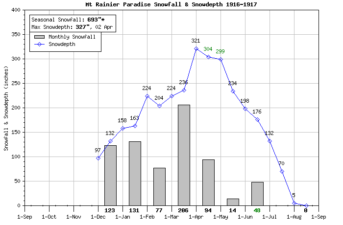
Here are plots of snowfall and snowdepth for the 6 seasons at Paradise which reached either 300" of snowdepth or 1000" of snowfall. Data for Paradise in the archives at the National Climatic Data Center begins on December 1, 1916 -- about 250-300" of snowfall must have fallen in September, October, and November 1916 to produce the 97" depth on that date, so the true season total is probably close to 1000" for the 1916-17 season:
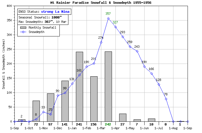
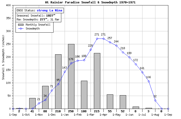
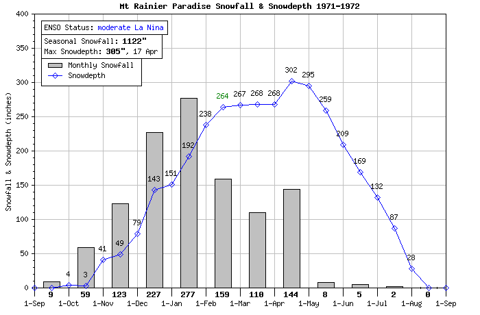
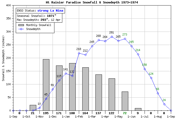
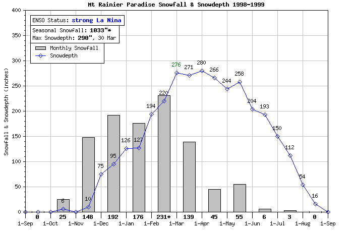
These plots are generated by a script on my website at www.skimountaineer.com/CascadeSki/ParadiseCraterLakeSnow.php -- I need to update the data on that page to include the seasons since 2006.
Replied by Amar Andalkar on topic Re: Mount Rainier Paradise reaches 200" snow depth
Another piece of interesting trivia from my memory archives is that there was 186" of snow still on the ground at Paradise on July 18th (I think 1975). Didn't 1974-75 break or nearly break the record of snowfall from '71-'72? It must have been a pretty crappy early summer.
It was 1973-74 which almost tied the snowfall record and holds many daily snowdepth records, in 1974-75 the snowfall and depth was much less (although still far above normal). The summer of 1974 holds all of the late-season daily snowdepth records at Paradise from about May 14 onward, although it was tied or barely exceeded in 1999 for a few days around July 4-9. It looks like the snowdepth on July 18, 1974, was 122", while the last day at or above 186" was June 21. The last day above 200" was June 18, with July 22 the last day above 100". The snowpack at the measuring stake did not melt away to zero until August 27, 1974. Following a bit of snow on October 20-21 which quickly melted, new snowfall which did not melt away until the next summer started on October 29 -- so the snow stake was only snow-free in 1974 for just over 2 months in late summer and early autumn.
Here are plots of snowfall and snowdepth for the 6 seasons at Paradise which reached either 300" of snowdepth or 1000" of snowfall. Data for Paradise in the archives at the National Climatic Data Center begins on December 1, 1916 -- about 250-300" of snowfall must have fallen in September, October, and November 1916 to produce the 97" depth on that date, so the true season total is probably close to 1000" for the 1916-17 season:
These plots are generated by a script on my website at www.skimountaineer.com/CascadeSki/ParadiseCraterLakeSnow.php -- I need to update the data on that page to include the seasons since 2006.
Please Log in or Create an account to join the conversation.
- garyabrill
- [garyabrill]
-
- Offline
- Senior Member
-
Less
More
- Posts: 464
- Thank you received: 0
15 Mar 2011 20:31 #198944
by garyabrill
Replied by garyabrill on topic Re: Mount Rainier Paradise reaches 200" snow depth
Thanks, Amar for the additional data and correction. I recall the (1974) snow season as being Crystal's greatest. And it was deep in April. They had to plow out a trough maybe 6' deep at the top of Sunnyside and for many years there were marks on the chair towers showing the maximum depths at individual towers.
The best ski year of all those years that I recall was 1970-71, which not only snowed a lot but was also quite cool. Skykomish had maybe 6' for quite awhile that winter, something that didn't
happen again until two years ago. The great skiing of 1970-71 was not approached again until the 3-1/2 week period in 1990, much of the winter of 1996-97 and, of course, 1998-99.
I did find out that NWAC does indeed have archives that should date back to 1990. If they successfully retrieve those archives we should be able to see the records from the key period in 1990.
Please Log in or Create an account to join the conversation.
- Amar Andalkar
- [andalkar]
-
Topic Author
- Offline
- Premium Member
-
Less
More
- Posts: 635
- Thank you received: 0
16 Mar 2011 14:55 #198971
by Amar Andalkar
The data has been updated through the 2010 season, which took a lot more work than expected. Unfortunately, the snowfall data at Paradise (which is manually measured and recorded daily by a park ranger) has been more unreliable the past few years than it previously was, due in part to the road not opening at all for several-day stretches numerous times, but perhaps due to other issues as well. Where snowfall data has been missing, I've estimated the snowfall for the missing days using NWAC telemetry, and added it to the monthly totals -- estimated amounts are marked with an *.
Here is the plot for the most recent La Nina season prior to the current season:
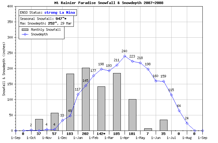
Replied by Amar Andalkar on topic Re: Mount Rainier Paradise reaches 200" snow depth
These plots are generated by a script on my website at www.skimountaineer.com/CascadeSki/ParadiseCraterLakeSnow.php -- I need to update the data on that page to include the seasons since 2006.
The data has been updated through the 2010 season, which took a lot more work than expected. Unfortunately, the snowfall data at Paradise (which is manually measured and recorded daily by a park ranger) has been more unreliable the past few years than it previously was, due in part to the road not opening at all for several-day stretches numerous times, but perhaps due to other issues as well. Where snowfall data has been missing, I've estimated the snowfall for the missing days using NWAC telemetry, and added it to the monthly totals -- estimated amounts are marked with an *.
Here is the plot for the most recent La Nina season prior to the current season:
Please Log in or Create an account to join the conversation.
- garyabrill
- [garyabrill]
-
- Offline
- Senior Member
-
Less
More
- Posts: 464
- Thank you received: 0
16 Mar 2011 16:30 #198979
by garyabrill
Replied by garyabrill on topic Re: Mount Rainier Paradise reaches 200" snow depth
So much for 1990 :'( Although the avalanche observations are correct.
Kenny from NWAC says that he added up snowfall records from January 18th to February 17th of that year by combining both WDOT and ski area reports (since each was missing some data). A possibly slightly overstated total for that period was still an impressive 285" (so I don't know where I got the earlier number of nearly 500"). But not to despair, so far this month Baker has had 227" with 105" in the past 7 days - our first 100" week in a long while")
The biggest weekly total I ever recall as a Baker skier in the late 60's, 70's and 80's was 109" all of which fell in about 4 and 1/2 days. I skied that Saturday and it was surprisingly well settled despite being cool.
The biggest 3 day total I know of was 99" preceding the Yodelin avalanche (again that comes from verbal communication with 2 friends who were ski patrols at Stevens at that time).
The biggest one day total was at Crystal about 10-15 years ago with 65". My sister was riding the lifts that day and said that "They all looked like they were stuck on flypaper." Nobody was going anywhere. Ken confirmed that snowfall; as he said he was forecasting that day and they still don't know how that happened.
I skied a dump of 48" in one day at Baker in the 1970's. It was 12 degrees and sunny with great skiing, about 20F and sunny in Bellingham. The freeway was only plowed in one lane that morning north of Mt. Vernon and there was about 20" on I-5. At the end of the day, by the time I got to south Everett, it turned to rain and snow mixed, as it was in Seattle at 36F - the same temperature and weather as at Crystal that day. An arctic front was stalled in the Everett area. The biggest temperature difference I ever recall.
Kenny from NWAC says that he added up snowfall records from January 18th to February 17th of that year by combining both WDOT and ski area reports (since each was missing some data). A possibly slightly overstated total for that period was still an impressive 285" (so I don't know where I got the earlier number of nearly 500"). But not to despair, so far this month Baker has had 227" with 105" in the past 7 days - our first 100" week in a long while
The biggest weekly total I ever recall as a Baker skier in the late 60's, 70's and 80's was 109" all of which fell in about 4 and 1/2 days. I skied that Saturday and it was surprisingly well settled despite being cool.
The biggest 3 day total I know of was 99" preceding the Yodelin avalanche (again that comes from verbal communication with 2 friends who were ski patrols at Stevens at that time).
The biggest one day total was at Crystal about 10-15 years ago with 65". My sister was riding the lifts that day and said that "They all looked like they were stuck on flypaper." Nobody was going anywhere. Ken confirmed that snowfall; as he said he was forecasting that day and they still don't know how that happened.
I skied a dump of 48" in one day at Baker in the 1970's. It was 12 degrees and sunny with great skiing, about 20F and sunny in Bellingham. The freeway was only plowed in one lane that morning north of Mt. Vernon and there was about 20" on I-5. At the end of the day, by the time I got to south Everett, it turned to rain and snow mixed, as it was in Seattle at 36F - the same temperature and weather as at Crystal that day. An arctic front was stalled in the Everett area. The biggest temperature difference I ever recall.
Please Log in or Create an account to join the conversation.
- Amar Andalkar
- [andalkar]
-
Topic Author
- Offline
- Premium Member
-
Less
More
- Posts: 635
- Thank you received: 0
17 Mar 2011 12:42 #199010
by Amar Andalkar
Where are you getting the monthly snowfall numbers for Baker? I don't see any seasonal or monthly snowfall totals on their website (except outdated info at www.mtbaker.us/1011/ski-area-info/snowfall-statistics/), I wish they would post current numbers each day. If I add up the NWAC telemetry, I get about 176" for March and 101" for the last 7 days (including today's 14") -- a pretty great week and half-month:
24 Hr Total
Date New Depth
Feb 26 0" 153"
Feb 27 12" 159"
Feb 28 14" 168"
Mar 1 10" 172"
Mar 2 8" 174"
Mar 3 4" 181" -- error in 24 hour, should be about 9-10" new
Mar 4 9" 183"
Mar 5 13" 189"
Mar 6 2" 185"
Mar 7 1" 182"
Mar 8 6" 183"
Mar 9 12" 191"
Mar 10 10" 197"
Mar 11 15" 207"
Mar 12 16" 219"
Mar 13 13" 220"
Mar 14 14" 227"
Mar 15 10" 230"
Mar 16 19" 245"
Mar 17 14" 250" -- reached 253" overnight before settlement
The 65" snowfall at Crystal was on Thursday, February 24, 1994 -- Paradise received 44" new that day (misrecorded in the NCDC archives as being on the 23rd), while Longmire (2700 ft) got 25" new and Government Camp (4000 ft on Mt Hood) got 25" too, which was the 3rd or 4th greatest one-day snowfall at each of those three sites.
Here are a couple of NWS technical papers about the event and its possible cause:
www.wrh.noaa.gov/wrh/97TAs/TA9712/ta97-12.html
www.wrh.noaa.gov/wrh/techMemos/254/TechMemo_NWS_WR-254.pdf
That 65" snowfall was partly responsible for me moving out to Seattle -- it made national news and I heard about it on the east coast, as I was trying to decide which grad school to attend for my physics PhD. I had gotten admitted to 4 schools out of the 13 I had applied to, including the UW (barely a top-15 physics program at the time) and three other schools on the east coast (Yale, Johns Hopkins, Duke), all of which were more prestigious and higher ranked than the UW in physics. I picked the UW sight-unseen (I'd never been to WA or Seattle) over the east coast schools after hearing about the 65" snowfall, because I knew that I wanted to move someplace with real mountains and big snowfall. Choosing the UW and moving to Seattle remains the single best decision I've ever made in my life (my mom disagrees, she nearly went apoplectic at my decision, and still can not believe that I chose the UW over Yale).
During my first winter skiing Crystal in 1994-95, that 65" dump was still fresh in a lot of people's minds, and I heard a lot of chairlift stories from those who claimed to have been there that day. I've still never seen any actual photos of the day, though . . .
Replied by Amar Andalkar on topic Re: Mount Rainier Paradise reaches 200" snow depth
So much for 1990 :'( Although the avalanche observations are correct.
Kenny from NWAC says that he added up snowfall records from January 18th to February 17th of that year by combining both WDOT and ski area reports (since each was missing some data). A possibly slightly overstated total for that period was still an impressive 285" (so I don't know where I got the earlier number of nearly 500"). But not to despair, so far this month Baker has had 227" with 105" in the past 7 days - our first 100" week in a long while
Where are you getting the monthly snowfall numbers for Baker? I don't see any seasonal or monthly snowfall totals on their website (except outdated info at www.mtbaker.us/1011/ski-area-info/snowfall-statistics/), I wish they would post current numbers each day. If I add up the NWAC telemetry, I get about 176" for March and 101" for the last 7 days (including today's 14") -- a pretty great week and half-month:
24 Hr Total
Date New Depth
Feb 26 0" 153"
Feb 27 12" 159"
Feb 28 14" 168"
Mar 1 10" 172"
Mar 2 8" 174"
Mar 3 4" 181" -- error in 24 hour, should be about 9-10" new
Mar 4 9" 183"
Mar 5 13" 189"
Mar 6 2" 185"
Mar 7 1" 182"
Mar 8 6" 183"
Mar 9 12" 191"
Mar 10 10" 197"
Mar 11 15" 207"
Mar 12 16" 219"
Mar 13 13" 220"
Mar 14 14" 227"
Mar 15 10" 230"
Mar 16 19" 245"
Mar 17 14" 250" -- reached 253" overnight before settlement
The biggest one day total was at Crystal about 10-15 years ago with 65". My sister was riding the lifts that day and said that "They all looked like they were stuck on flypaper." Nobody was going anywhere. Ken confirmed that snowfall; as he said he was forecasting that day and they still don't know how that happened.
The 65" snowfall at Crystal was on Thursday, February 24, 1994 -- Paradise received 44" new that day (misrecorded in the NCDC archives as being on the 23rd), while Longmire (2700 ft) got 25" new and Government Camp (4000 ft on Mt Hood) got 25" too, which was the 3rd or 4th greatest one-day snowfall at each of those three sites.
Here are a couple of NWS technical papers about the event and its possible cause:
www.wrh.noaa.gov/wrh/97TAs/TA9712/ta97-12.html
www.wrh.noaa.gov/wrh/techMemos/254/TechMemo_NWS_WR-254.pdf
That 65" snowfall was partly responsible for me moving out to Seattle -- it made national news and I heard about it on the east coast, as I was trying to decide which grad school to attend for my physics PhD. I had gotten admitted to 4 schools out of the 13 I had applied to, including the UW (barely a top-15 physics program at the time) and three other schools on the east coast (Yale, Johns Hopkins, Duke), all of which were more prestigious and higher ranked than the UW in physics. I picked the UW sight-unseen (I'd never been to WA or Seattle) over the east coast schools after hearing about the 65" snowfall, because I knew that I wanted to move someplace with real mountains and big snowfall. Choosing the UW and moving to Seattle remains the single best decision I've ever made in my life (my mom disagrees, she nearly went apoplectic at my decision, and still can not believe that I chose the UW over Yale).
During my first winter skiing Crystal in 1994-95, that 65" dump was still fresh in a lot of people's minds, and I heard a lot of chairlift stories from those who claimed to have been there that day. I've still never seen any actual photos of the day, though . . .
Please Log in or Create an account to join the conversation.
- garyabrill
- [garyabrill]
-
- Offline
- Senior Member
-
Less
More
- Posts: 464
- Thank you received: 0
18 Mar 2011 13:42 - 18 Mar 2011 18:31 #199030
by garyabrill
I got those snowfall totals from Kenny by phone. He said that while he had little confidence in the accuracy of some of the old records, he felt pretty comfortable with today's (modern era) data. I just took his word for it, I didn't try to double-check what he told me.
Replied by garyabrill on topic Re: Mount Rainier Paradise reaches 200" snow depth
Where are you getting the monthly snowfall numbers for Baker? I don't see any seasonal or monthly snowfall totals on their website (except outdated info at www.mtbaker.us/1011/ski-area-info/snowfall-statistics/), I wish they would post current numbers each day. If I add up the NWAC telemetry, I get about 176" for March and 101" for the last 7 days (including today's 14") -- a pretty great week and half-month:
I got those snowfall totals from Kenny by phone. He said that while he had little confidence in the accuracy of some of the old records, he felt pretty comfortable with today's (modern era) data. I just took his word for it, I didn't try to double-check what he told me.
Please Log in or Create an account to join the conversation.
- Amar Andalkar
- [andalkar]
-
Topic Author
- Offline
- Premium Member
-
Less
More
- Posts: 635
- Thank you received: 0
19 Mar 2011 20:44 - 20 Mar 2011 15:35 #199053
by Amar Andalkar
Replied by Amar Andalkar on topic Re: Mount Rainier Paradise reaches 200" snow depth
More good snow news!! I noticed today that the snowdepth on Mt Shasta had suddenly reached 200" after a massive 4-foot dump, and decided to check the numbers at a bunch of other sites. It turns out that several more telemetry sites in the Cascade Range and nearby have exceeded the 200" snowdepth mark in the past few days:
The Upper Squamish River BCRFC site at 4500 ft on a ridge west of Mt Cayley (a Cascade volcano about 15 miles west of Whistler) topped 200" on March 10, then reached 239" on March 16, and now has 228". This site often has snowdepths within a few % of Mt Baker Ski Area (as it does now), and it receives about 50% more snowfall than Whistler Mountain's 5400 ft measurement plot, 20 miles to the east. Incidentally, Whistler's snowdepth reached 156" on March 16, which is 150% of normal and which it has only exceeded in two other seasons (1974 and 1999) since records begin in 1972. Whistler now has 533" of snowfall on the season, its 2nd highest total as of late March behind only 1998-99, and so this makes it back-to-back huge seasons for southwestern BC and Whistler. The 588" of snowfall in 2009-10 was its 2nd highest total ever, but is almost certain to be exceeded this season.
As per previous posts in this thread, Mt Baker Ski Area (4200 ft) topped 200" on March 10, then reached 253" on March 16 (over 150% of normal), and now has about 235", which is the most of any telemetry site in North America as far as I know. The ski area is not posting snowfall stats this season, but it must be over 650" by now. A depth of 273" is reported by Baker Ski Area atop Pan Dome at 5000 ft, however, the deepest base reported by any ski area in North America is at Mt Washington on Vancouver Island, with 281" now at their mid-mountain site (about 4500 ft) and which passed 200" way back on February 17, just as this month-long cycle of heavy snowfall in the Northwest began.
Brown Top SNOTEL (5830 ft, on the long ridge extending east from Mt Redoubt in the North Cascades) reached 202" on March 16-17, and now has 188" after some settlement.
Easy Pass SNOTEL (5270 ft, 8 miles east of Mt Shuksan) has no working snowdepth sensor, but its snow-water equivalent is now over 90", implying a snowdepth of over 220", perhaps near 240".
Buckinghorse SNOTEL (4870 ft, in the Olympics, 12 miles SE of Mt Olympus) has apparently had its snowdepth sensor (mounted much too low) buried by the rising snowpack, and so is stuck reading only 196" since March 10. But its snow-water equivalent is now over 80", implying a snowdepth of over 200", perhaps near 220".
Cayuse Pass SNOTEL (5240 ft, near the hairpin turn on SR 410 above Cayuse Pass) reached 202" on March 16, and now has 196".
And Paradise continues to hover near and above 200" for the past 9 days since March 10, with continuing new snowfall just offsetting the ongoing settlement of the snowpack. Snowfall for the season-to-date is reported at 658" as of this morning, with a depth of 208" on the NPS snow stake and 201" on the NWAC telemetry.
Over 400 miles to the south, on Mt Shasta the Old Ski Bowl site (7600 ft) topped 200" today (March 19), which is over 160% of normal. Nearly 4 ft of snow has fallen in the last 2 days -- plus another 2-3 ft of snow are expected in the next 2 days. It's great to have a long spring and early-summer ski season already ensured on Shasta, where the snowpack is so variable from year to year.
Lassen Peak, Lake Helen (8250 ft), topped 200" on March 16, and now has over 227", about 130% of normal. More than 2 ft of snow has fallen in the last 2 days -- plus another 3-4 ft of snow are expected in the next 2 days. If that snowfall occurs as forecast, Lassen's snowdepth will easily pass the Baker Ski Area site.
The maximum snowdepth at any site in Oregon remains Mt Hood Timberline Lodge (6000 ft) with almost 170" now, about 105% of normal. The Crater Lake Rim site (7050 ft) had 153" on March 17, but has been down since then. No other telemetry sites in Oregon are over 140", and sites in WA and northern CA are doing much better than Oregon as a percent of normal, but in general the Oregon Cascades are now at or above normal snowdepth. Timberline is reporting seasonal snowfall of 520", while Mount Bachelor is reporting 490" and Crater Lake has received 480" at park headquarters (6400 ft).
Overall for the Cascade Range, this now qualifies as a great snow season, and it's the first season since 2005-2006 to be above-normal for snowfall and snowdepth over the entire length of the range (700+ miles) from southwestern BC to northern California. It has definitely not been a typical La Nina season, except for the last month since mid-February which has looked like a classic La Nina-influenced weather pattern. The snowpack will likely continue building somewhat for the next month, until mid-April. There should be a lot of great route options for spring and summer skiing throughout the entire range this year.
Please Log in or Create an account to join the conversation.
- garyabrill
- [garyabrill]
-
- Offline
- Senior Member
-
Less
More
- Posts: 464
- Thank you received: 0
20 Mar 2011 14:03 #199059
by garyabrill
Replied by garyabrill on topic Re: Mount Rainier Paradise reaches 200" snow depth
Smoley Hokes! And it's not just the Cascades; there are great snow depths extending all the way south to Mt. Whitney with 136% to 181% of normal when I last checked a few days ago. Mammoth reports a pretty doggone good 167" at the base, 200" at mid-mountain and a whopping 260" at the top, with a trifling 55"new. Mammoth has had over 500" of snowfall this winter according to Howard Sheckter. I suspect some of the Tahoe areas are equally well-endowed - to borrow a term.
The fire hose has been washing the entire west coast at different times with a pretty good dousing of H2O.
You know when I first skied Whistler in 1968 we were told (it was written on a chalkboard) that the mountain had 33' of base. I doubted that could be true; still, there were a bunch of buildings on the flats below the Roundhouse and all that was showing of them were the chimneys/vent pipes sticking directly out of the snow?
Please Log in or Create an account to join the conversation.
- Amar Andalkar
- [andalkar]
-
Topic Author
- Offline
- Premium Member
-
Less
More
- Posts: 635
- Thank you received: 0
20 Mar 2011 16:19 #199062
by Amar Andalkar
As expected, the continued heavy snowfall in California the past few days has sent Lassen Peak into the lead, passing Baker Ski Area overnight and reaching 239" of snowdepth early this morning, now the most of any telemetry site in North America. Mt Shasta Old Ski Bowl is up to 207".
Quite unusually for a La Nina season, the Sierra Nevada has had a huge snow year, although as is typical down there, much of the snowfall has come in isolated dumps of 5-15 ft per storm cycle, separated by long periods (weeks or even over a month) of sunshine and no snowfall. Another such storm cycle is underway this week as the storm track has shifted south of the Pacific Northwest, with 3-5 ft already fallen in the last 2 days and up to 6 ft of additional snowfall forecast for the Sierra over the next 5 days. A couple of telemetry sites in the Sierra have now topped 200":
The Meadow Lake CCSS site (7200 ft, north of I-80 and Lake Tahoe) reached 197" on March 17, leveled off for a day, and with renewed snowfall appears to have reached 229" last night, although the data has been very flaky and intermittent -- it's hard to tell the correct data from the spurious data (e.g. the 276" values).
Leavitt Lake SNOTEL (9600 ft, west of Bridgeport, well south of Lake Tahoe) topped 200" on March 18, and now has 218" (the 317" values are spurious).
These are normally the two highest-snowdepth telemetry sites in the Sierra Nevada, although they each average about 25-30% less snowdepth than the Lassen Peak, Lake Helen site which has the largest average snowdepth in California.
The Mammoth Ski Patrol's telemetry site at 9000 ft has 175" (see patrol.mammothmountain.com/ for lots of nice snowpack info and other stuff, including their Avalanche Path Atlas ), while the nearby Mammoth Pass USBR site (9300 ft) has 174" as of this morning. The ski area is reporting 499" of snowfall for the season as of this morning -- so it's over 500" now for sure. The average annual snowfall at Mammoth (main lodge, 8900 ft) since 1969 is about 380", so it's already over 130% of normal snowfall with lots more snow on the way.
As for the Tahoe ski areas, the largest snowdepths and snowfall totals according the ski areas themselves (take with a large grain of salt -- no telemetry sites near the ski areas come close to these numbers):
Sugar Bowl has gotten 46-64" new the last 2 days, and now reports a 287" snowdepth at its summit -- no seasonal snowfall totals though.
Squaw Valley has gotten 38-48" new the last 2 days with a 190" upper snowdepth, and a snowfall of 570" at 8200 ft according to their Snowfall Tracker 2010-11 .
Alpine Meadows has gotten 39-54" new the last 2 days, and now reports a 297" snowdepth at its summit -- no seasonal snowfall totals though. It's also "Closed - Too much snow to safely enjoy. (Extreme Avalanche Danger and High Winds)".
Sierra at Tahoe has gotten 19-45" new the last 2 days, and now reports a 208" snowdepth at its summit -- no seasonal snowfall totals though.
Kirkwood has gotten 56-62" new the last 2 days, and now reports a 198-247" snowdepth, with seasonal snowfall of 607-621". However, Kirkwood's snowfall and snowdepth numbers are the most suspect of any ski area that I've tracked, they often just don't add up (literally). There was an obvious instance of double-counting daily snowfall totals during the huge late-December 2010 storm cycle, which remained uncorrected later, and their base depths often mysteriously stay constant for days or weeks after a storm -- while those of all other nearby ski areas are shrinking as they must due to settlement. Unfortunately, Kirkwood's numbers are for entertainment purposes only and are nearly useless scientifically, which is a shame since they probably get the most snowfall of any CA ski area (about 470" on average, roughly the same as Sugar Bowl).
Replied by Amar Andalkar on topic Re: Mount Rainier Paradise reaches 200" snow depth
Lassen Peak, Lake Helen (8250 ft), topped 200" on March 16, and now has over 227", about 130% of normal. More than 2 ft of snow has fallen in the last 2 days -- plus another 3-4 ft of snow are expected in the next 2 days. If that snowfall occurs as forecast, Lassen's snowdepth will easily pass the Baker Ski Area site.
As expected, the continued heavy snowfall in California the past few days has sent Lassen Peak into the lead, passing Baker Ski Area overnight and reaching 239" of snowdepth early this morning, now the most of any telemetry site in North America. Mt Shasta Old Ski Bowl is up to 207".
Quite unusually for a La Nina season, the Sierra Nevada has had a huge snow year, although as is typical down there, much of the snowfall has come in isolated dumps of 5-15 ft per storm cycle, separated by long periods (weeks or even over a month) of sunshine and no snowfall. Another such storm cycle is underway this week as the storm track has shifted south of the Pacific Northwest, with 3-5 ft already fallen in the last 2 days and up to 6 ft of additional snowfall forecast for the Sierra over the next 5 days. A couple of telemetry sites in the Sierra have now topped 200":
The Meadow Lake CCSS site (7200 ft, north of I-80 and Lake Tahoe) reached 197" on March 17, leveled off for a day, and with renewed snowfall appears to have reached 229" last night, although the data has been very flaky and intermittent -- it's hard to tell the correct data from the spurious data (e.g. the 276" values).
Leavitt Lake SNOTEL (9600 ft, west of Bridgeport, well south of Lake Tahoe) topped 200" on March 18, and now has 218" (the 317" values are spurious).
These are normally the two highest-snowdepth telemetry sites in the Sierra Nevada, although they each average about 25-30% less snowdepth than the Lassen Peak, Lake Helen site which has the largest average snowdepth in California.
The Mammoth Ski Patrol's telemetry site at 9000 ft has 175" (see patrol.mammothmountain.com/ for lots of nice snowpack info and other stuff, including their Avalanche Path Atlas ), while the nearby Mammoth Pass USBR site (9300 ft) has 174" as of this morning. The ski area is reporting 499" of snowfall for the season as of this morning -- so it's over 500" now for sure. The average annual snowfall at Mammoth (main lodge, 8900 ft) since 1969 is about 380", so it's already over 130% of normal snowfall with lots more snow on the way.
As for the Tahoe ski areas, the largest snowdepths and snowfall totals according the ski areas themselves (take with a large grain of salt -- no telemetry sites near the ski areas come close to these numbers):
Sugar Bowl has gotten 46-64" new the last 2 days, and now reports a 287" snowdepth at its summit -- no seasonal snowfall totals though.
Squaw Valley has gotten 38-48" new the last 2 days with a 190" upper snowdepth, and a snowfall of 570" at 8200 ft according to their Snowfall Tracker 2010-11 .
Alpine Meadows has gotten 39-54" new the last 2 days, and now reports a 297" snowdepth at its summit -- no seasonal snowfall totals though. It's also "Closed - Too much snow to safely enjoy. (Extreme Avalanche Danger and High Winds)".
Sierra at Tahoe has gotten 19-45" new the last 2 days, and now reports a 208" snowdepth at its summit -- no seasonal snowfall totals though.
Kirkwood has gotten 56-62" new the last 2 days, and now reports a 198-247" snowdepth, with seasonal snowfall of 607-621". However, Kirkwood's snowfall and snowdepth numbers are the most suspect of any ski area that I've tracked, they often just don't add up (literally). There was an obvious instance of double-counting daily snowfall totals during the huge late-December 2010 storm cycle, which remained uncorrected later, and their base depths often mysteriously stay constant for days or weeks after a storm -- while those of all other nearby ski areas are shrinking as they must due to settlement. Unfortunately, Kirkwood's numbers are for entertainment purposes only and are nearly useless scientifically, which is a shame since they probably get the most snowfall of any CA ski area (about 470" on average, roughly the same as Sugar Bowl).
Please Log in or Create an account to join the conversation.
- Zap
- [Zap]
-
- Offline
- Platinum Member
-

Less
More
- Posts: 1212
- Thank you received: 3
20 Mar 2011 20:32 #199070
by Zap
Replied by Zap on topic Re: Mount Rainier Paradise reaches 200" snow depth
Amar,
Thanks for the latest snow data of the Tahoe and Eastern Sierra. Jill and I usually spend March, April and early May in The Sierra. With both of our recent surgeries, we're unfortunately missing it. During recent years, we get Kirkwood season passes because of their deep snowpack and terrain. I'm hoping the storm cycles keep rolling thru and buiding the bases for an extended spring/summer season. I just might be able to be back on skis by mid June.")
Thanks for the latest snow data of the Tahoe and Eastern Sierra. Jill and I usually spend March, April and early May in The Sierra. With both of our recent surgeries, we're unfortunately missing it. During recent years, we get Kirkwood season passes because of their deep snowpack and terrain. I'm hoping the storm cycles keep rolling thru and buiding the bases for an extended spring/summer season. I just might be able to be back on skis by mid June.
Please Log in or Create an account to join the conversation.