- Posts: 1012
- Thank you received: 0
Muiricane
- Joedabaker
- [Joedabaker]
-
 Topic Author
- Offline
- Platinum Member
-

Less
More
12 Feb 2011 21:41 #197797
by Joedabaker
Muiricane was created by Joedabaker
Wonder if there's still a roof at the shelter?
Check out those wind totals...
MM/DD Hour Temp RH Wind Wind Wind Wind Solar
PST F % Min Avg Max Dir W/m2
10100' 10100' 10100' 10100' 10100' 10100' 10100'
2 12 2100 7 92 48 83 110 249 1
2 12 2000 12 94 59 83 102 248 1
2 12 1900 13 95 87 112 130 239 1
2 12 1800 14 95 97 112 124 240 3
2 12 1700 14 95 96 111 127 246 23
2 12 1600 16 96 83 120 141 246 23
2 12 1500 12 94 107 132 155 242 46
2 12 1400 14 95 105 128 152 242 87
2 12 1300 14 95 95 117 137 239 114
2 12 1200 13 94 96 114 135 237 92
2 12 1100 14 94 97 112 131 243 77
2 12 1000 14 84 91 103 114 247 80
2 12 900 14 77 90 102 114 245 29
2 12 800 15 76 85 100 113 244 8
2 12 700 15 76 85 98 114 239 1
2 12 600 16 77 73 93 108 242 1
2 12 500 16 61 75 95 109 240 1
2 12 400 18 71 67 94 116 244 1
2 12 300 18 68 88 106 122 243 0
2 12 200 18 73 83 104 126 244 0
2 12 100 17 69 73 94 114 248 0
2 12 0 19
Please Log in or Create an account to join the conversation.
- haggis
- [haggis]
-
- Offline
- Senior Member
-

Less
More
- Posts: 255
- Thank you received: 0
12 Feb 2011 22:13 #197798
by haggis
Replied by haggis on topic Re: Muiricane
WOW! The minimum was a bad day in the mountains and the max is staggering at 155 mpg.
Please Log in or Create an account to join the conversation.
- fresh
- [fresh]
-
- Offline
- New Member
-

Less
More
- Posts: 18
- Thank you received: 0
12 Feb 2011 22:47 #197799
by fresh
Replied by fresh on topic Re: Muiricane
That's wild, so it was like a class 3 hurricane for most of the day up there! Certainly looked windy from Snoqualmie:
Please Log in or Create an account to join the conversation.
- mick_scott
- [powderslut]
-
- Offline
- New Member
-
Less
More
- Posts: 14
- Thank you received: 0
13 Feb 2011 00:31 #197732
by mick_scott
Replied by mick_scott on topic Re: Muiricane
Wowzers! Thanks for the post. Cool picture Fresh.
Please Log in or Create an account to join the conversation.
- wickstad
- [wickstad]
-
- Offline
- Senior Member
-
Less
More
- Posts: 253
- Thank you received: 0
13 Feb 2011 07:40 #197801
by wickstad
Replied by wickstad on topic Re: Muiricane
120mph at Mission yesterday. Is 155mph a new record?
Please Log in or Create an account to join the conversation.
- runcle
- [runcle]
-
- Offline
- New Member
-
Less
More
- Posts: 27
- Thank you received: 0
13 Feb 2011 07:55 #197802
by runcle
Replied by runcle on topic Re: Muiricane
Very cool pic! Wicked
Please Log in or Create an account to join the conversation.
- nedski
- [nedski]
-
- Offline
- New Member
-
Less
More
- Posts: 8
- Thank you received: 0
13 Feb 2011 18:06 #197811
by nedski
Replied by nedski on topic Re: Muiricane
I was going to post this, too. Ka Ra Zeee! Can a man stand, hold onto the ground in that?
Please Log in or Create an account to join the conversation.
- Boot
- [Boot]
-
- Offline
- Junior Member
-

Less
More
- Posts: 96
- Thank you received: 0
13 Feb 2011 20:36 #197816
by Boot
Replied by Boot on topic Re: Muiricane
Can anybody do the math on the wind chill at 155mph and 12 degrees?
Please Log in or Create an account to join the conversation.
- JPH
- [JPH]
-
- Offline
- Junior Member
-
Less
More
- Posts: 165
- Thank you received: 1
13 Feb 2011 20:47 - 13 Feb 2011 21:02 #197818
by JPH
Loose calculation here: (12 degrees F-32)/1.8 = -11 C * 155 mph wind = freakin cold!
Replied by JPH on topic Re: Muiricane
Can anybody do the math on the wind chill at 155mph and 12 degrees?
Loose calculation here: (12 degrees F-32)/1.8 = -11 C * 155 mph wind = freakin cold!
Please Log in or Create an account to join the conversation.
- Joedabaker
- [Joedabaker]
-
Topic Author
- Offline
- Platinum Member
-
Less
More
- Posts: 1012
- Thank you received: 0
13 Feb 2011 21:05 #197819
by Joedabaker
It's actually -25. According to NOAA, Wind speeds above 40 mph have little additional chilling affect.
I would think that if I was not rolling like tumbleweed across the snowfield, I would get a pretty good wind burn or sandblasting of pellets.
Nice picture Fresh!
Replied by Joedabaker on topic Re: Muiricane
Can anybody do the math on the wind chill at 155mph and 12 degrees?
It's actually -25. According to NOAA, Wind speeds above 40 mph have little additional chilling affect.
I would think that if I was not rolling like tumbleweed across the snowfield, I would get a pretty good wind burn or sandblasting of pellets.
Nice picture Fresh!
Please Log in or Create an account to join the conversation.
- Amar Andalkar
- [andalkar]
-
- Offline
- Premium Member
-

Less
More
- Posts: 635
- Thank you received: 0
14 Feb 2011 16:06 - 01 Mar 2011 11:58 #197859
by Amar Andalkar
I spent some time looking through the archived NWAC data today. As far as I can find, the 155 mph gust is the highest wind speed recorded at Camp Muir since that site was installed in September 2006, and also the highest wind recorded at any NWAC site over the full period of data. The previous highest was recorded at Mission Ridge, which reached 137 mph in January 2007 ( see this old thread for discussion on that event and previous Mission Ridge winds over 100 mph).
A list of days with winds over 100 mph at the Muir telemetry site:
06Sep2006: Muir station installed
06Nov2006: 121 mph (16" of rain in 48 hrs at Paradise, park flooded and closed until May)
29Apr2007: 125 mph
30Apr2007: 100 mph
12Nov2007: 119 mph
26Nov2007: 117 mph
02Dec2007: 111 mph
29Feb2008: 109 mph
03Mar2008: 100 mph
23Mar2008: 131 mph (avg 109 mph)
data missing for most of Oct-Nov-Dec 2008
27Jan2009: 110 mph
07Mar2009: 108 mph
15Mar2009: 126 mph
04May2009: 113 mph
17Oct2009: 106 mph
11Mar2010: 101 mph
20Mar2010: 106 mph
28Mar2010: 100 mph
19May2010: 113 mph
15Nov2010: 111 mph
12Jan2011: 109 mph
07Feb2011: 116 mph
11Feb2011: 109 mph
12Feb2011: 155 mph (avg 132 mph, min 107 mph)
There are large amounts of missing wind data at Muir, often for days or weeks at a time, due to the anemometer riming up and freezing solid, and also due to occasional communications problems. Nevertheless, the February 11-12 wind event is clearly exceptional in both magnitude and duration, far beyond any previous storm recorded in the data. Maximum gusts over 100 mph for 27 consecutive hours, average winds over 100 mph for 12 consecutive hours, and sustained winds never dropping below 105 mph for the 2 hour peak.
Here's the complete set of Muir data during this 2-day wind event:
Northwest Weather and Avalanche Center
Camp Muir, Mt Rainier National Park, Washington
Data also courtesy Mt Rainier National Park
Wind sensors unheated and may rime
MM/DD Hour Temp RH Wind Wind Wind Wind Solar
PST F % Min Avg Max Dir W/m2
10100' 10100' 10100' 10100' 10100' 10100' 10100'
2 11 0 22 48 1 5 22 254 0
2 11 100 23 34 4 18 36 255 0
2 11 200 22 45 16 29 41 250 0
2 11 300 22 38 19 32 48 250 0
2 11 400 21 28 28 46 62 243 0
2 11 500 19 51 32 53 71 247 0
2 11 600 18 31 48 63 87 249 0
2 11 700 18 40 43 67 85 250 0
2 11 800 17 60 57 74 85 243 17
2 11 900 17 49 68 79 91 242 122
2 11 1000 18 49 69 82 97 247 245
2 11 1100 18 33 65 81 95 247 316
2 11 1200 19 27 44 77 104 245 322
2 11 1300 19 93 28 65 83 251 311
2 11 1400 20 91 42 70 85 248 283
2 11 1500 18 87 47 71 87 246 197
2 11 1600 17 92 53 71 87 249 108
2 11 1700 18 95 48 76 92 249 40
2 11 1800 19 96 51 76 95 249 4
2 11 1900 19 96 54 77 93 250 1
2 11 2000 19 91 57 83 100 245 0
2 11 2100 20 81 70 85 109 244 1
2 11 2200 20 80 62 83 101 242 0
2 11 2300 20 31 68 84 103 245 1
2 12 0 19 44 58 83 100 243 0
2 12 100 17 69 73 94 114 248 0
2 12 200 18 73 83 104 126 244 0
2 12 300 18 68 88 106 122 243 0
2 12 400 18 71 67 94 116 244 1
2 12 500 16 61 75 95 109 240 1
2 12 600 16 77 73 93 108 242 1
2 12 700 15 76 85 98 114 239 1
2 12 800 15 76 85 100 113 244 8
2 12 900 14 77 90 102 114 245 29
2 12 1000 14 84 91 103 114 247 80
2 12 1100 14 94 97 112 131 243 77
2 12 1200 13 94 96 114 135 237 92
2 12 1300 14 95 95 117 137 239 114
2 12 1400 14 95 105 128 152 242 87
2 12 1500 12 94 107 132 155 242 46
2 12 1600 16 96 83 120 141 246 23
2 12 1700 14 95 96 111 127 246 23
2 12 1800 14 95 97 112 124 240 3
2 12 1900 13 95 87 112 130 239 1
2 12 2000 12 94 59 83 102 248 1
2 12 2100 7 92 48 83 110 249 1
2 12 2200 5 92 41 80 104 247 1
2 12 2300 4 91 25 53 85 242 0
2 13 0 4 91 14 50 76 241 0
2 13 100 4 91 57 72 83 237 1
2 13 200 4 91 37 58 77 234 0
2 13 300 4 91 23 48 66 237 0
2 13 400 3 91 12 34 51 249 0
2 13 500 12 94 8 23 38 251 0
2 13 600 15 94 4 11 23 276 0
P.S. Here's a list of days with winds over 100 mph at Mission Ridge, since the January 2007 maximum in that older thread :
12Nov2007: 105 mph
03Dec2007: 100 mph
21Jan2008: 105 mph
07Feb2008: 116 mph
08Feb2008: 112 mph
31Dec2008: 103 mph
06Jan2009: 121 mph
15Jan2010: 93 mph (no winds over 100 mph in the entire 2009-10 season)
15Nov2010: 105 mph
12Jan2011: 101 mph
13Jan2011: 105 mph
16Jan2011: 100 mph
17Jan2011: 119 mph
04Feb2011: 104 mph
06Feb2011: 100 mph
12Feb2011: 120 mph
[size=small](Edited for a few minor fixes.)[/size]
Replied by Amar Andalkar on topic Re: Muiricane
120mph at Mission yesterday. Is 155mph a new record?
I spent some time looking through the archived NWAC data today. As far as I can find, the 155 mph gust is the highest wind speed recorded at Camp Muir since that site was installed in September 2006, and also the highest wind recorded at any NWAC site over the full period of data. The previous highest was recorded at Mission Ridge, which reached 137 mph in January 2007 ( see this old thread for discussion on that event and previous Mission Ridge winds over 100 mph).
A list of days with winds over 100 mph at the Muir telemetry site:
06Sep2006: Muir station installed
06Nov2006: 121 mph (16" of rain in 48 hrs at Paradise, park flooded and closed until May)
29Apr2007: 125 mph
30Apr2007: 100 mph
12Nov2007: 119 mph
26Nov2007: 117 mph
02Dec2007: 111 mph
29Feb2008: 109 mph
03Mar2008: 100 mph
23Mar2008: 131 mph (avg 109 mph)
data missing for most of Oct-Nov-Dec 2008
27Jan2009: 110 mph
07Mar2009: 108 mph
15Mar2009: 126 mph
04May2009: 113 mph
17Oct2009: 106 mph
11Mar2010: 101 mph
20Mar2010: 106 mph
28Mar2010: 100 mph
19May2010: 113 mph
15Nov2010: 111 mph
12Jan2011: 109 mph
07Feb2011: 116 mph
11Feb2011: 109 mph
12Feb2011: 155 mph (avg 132 mph, min 107 mph)
There are large amounts of missing wind data at Muir, often for days or weeks at a time, due to the anemometer riming up and freezing solid, and also due to occasional communications problems. Nevertheless, the February 11-12 wind event is clearly exceptional in both magnitude and duration, far beyond any previous storm recorded in the data. Maximum gusts over 100 mph for 27 consecutive hours, average winds over 100 mph for 12 consecutive hours, and sustained winds never dropping below 105 mph for the 2 hour peak.
Here's the complete set of Muir data during this 2-day wind event:
Northwest Weather and Avalanche Center
Camp Muir, Mt Rainier National Park, Washington
Data also courtesy Mt Rainier National Park
Wind sensors unheated and may rime
MM/DD Hour Temp RH Wind Wind Wind Wind Solar
PST F % Min Avg Max Dir W/m2
10100' 10100' 10100' 10100' 10100' 10100' 10100'
2 11 0 22 48 1 5 22 254 0
2 11 100 23 34 4 18 36 255 0
2 11 200 22 45 16 29 41 250 0
2 11 300 22 38 19 32 48 250 0
2 11 400 21 28 28 46 62 243 0
2 11 500 19 51 32 53 71 247 0
2 11 600 18 31 48 63 87 249 0
2 11 700 18 40 43 67 85 250 0
2 11 800 17 60 57 74 85 243 17
2 11 900 17 49 68 79 91 242 122
2 11 1000 18 49 69 82 97 247 245
2 11 1100 18 33 65 81 95 247 316
2 11 1200 19 27 44 77 104 245 322
2 11 1300 19 93 28 65 83 251 311
2 11 1400 20 91 42 70 85 248 283
2 11 1500 18 87 47 71 87 246 197
2 11 1600 17 92 53 71 87 249 108
2 11 1700 18 95 48 76 92 249 40
2 11 1800 19 96 51 76 95 249 4
2 11 1900 19 96 54 77 93 250 1
2 11 2000 19 91 57 83 100 245 0
2 11 2100 20 81 70 85 109 244 1
2 11 2200 20 80 62 83 101 242 0
2 11 2300 20 31 68 84 103 245 1
2 12 0 19 44 58 83 100 243 0
2 12 100 17 69 73 94 114 248 0
2 12 200 18 73 83 104 126 244 0
2 12 300 18 68 88 106 122 243 0
2 12 400 18 71 67 94 116 244 1
2 12 500 16 61 75 95 109 240 1
2 12 600 16 77 73 93 108 242 1
2 12 700 15 76 85 98 114 239 1
2 12 800 15 76 85 100 113 244 8
2 12 900 14 77 90 102 114 245 29
2 12 1000 14 84 91 103 114 247 80
2 12 1100 14 94 97 112 131 243 77
2 12 1200 13 94 96 114 135 237 92
2 12 1300 14 95 95 117 137 239 114
2 12 1400 14 95 105 128 152 242 87
2 12 1500 12 94 107 132 155 242 46
2 12 1600 16 96 83 120 141 246 23
2 12 1700 14 95 96 111 127 246 23
2 12 1800 14 95 97 112 124 240 3
2 12 1900 13 95 87 112 130 239 1
2 12 2000 12 94 59 83 102 248 1
2 12 2100 7 92 48 83 110 249 1
2 12 2200 5 92 41 80 104 247 1
2 12 2300 4 91 25 53 85 242 0
2 13 0 4 91 14 50 76 241 0
2 13 100 4 91 57 72 83 237 1
2 13 200 4 91 37 58 77 234 0
2 13 300 4 91 23 48 66 237 0
2 13 400 3 91 12 34 51 249 0
2 13 500 12 94 8 23 38 251 0
2 13 600 15 94 4 11 23 276 0
P.S. Here's a list of days with winds over 100 mph at Mission Ridge, since the January 2007 maximum in that older thread :
12Nov2007: 105 mph
03Dec2007: 100 mph
21Jan2008: 105 mph
07Feb2008: 116 mph
08Feb2008: 112 mph
31Dec2008: 103 mph
06Jan2009: 121 mph
15Jan2010: 93 mph (no winds over 100 mph in the entire 2009-10 season)
15Nov2010: 105 mph
12Jan2011: 101 mph
13Jan2011: 105 mph
16Jan2011: 100 mph
17Jan2011: 119 mph
04Feb2011: 104 mph
06Feb2011: 100 mph
12Feb2011: 120 mph
[size=small](Edited for a few minor fixes.)[/size]
Please Log in or Create an account to join the conversation.
- MattT
- [MattT]
-
- Offline
- Junior Member
-
Less
More
- Posts: 62
- Thank you received: 0
14 Feb 2011 22:25 #197877
by MattT
Replied by MattT on topic Re: Muiricane
you have any idea the specs on the specific instrument the NWAC uses for this station? in 150+ mph within its calibrated ability? i guess aka, how reliable are the numbers even before it breaks 3 digits?
good stuff though, would love to see some footage up there from 2 12 1500!
good stuff though, would love to see some footage up there from 2 12 1500!
Please Log in or Create an account to join the conversation.
- Amar Andalkar
- [andalkar]
-
- Offline
- Premium Member
-
Less
More
- Posts: 635
- Thank you received: 0
14 Feb 2011 23:28 #197881
by Amar Andalkar
Replied by Amar Andalkar on topic Re: Muiricane
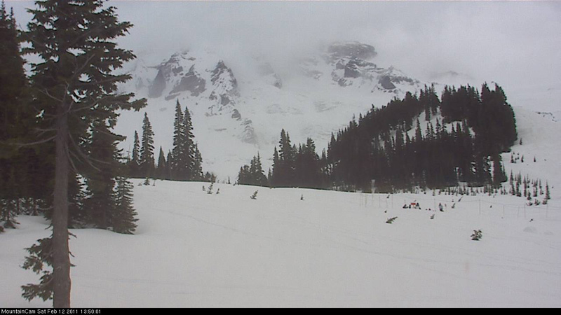
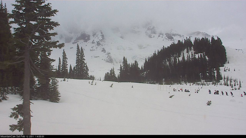
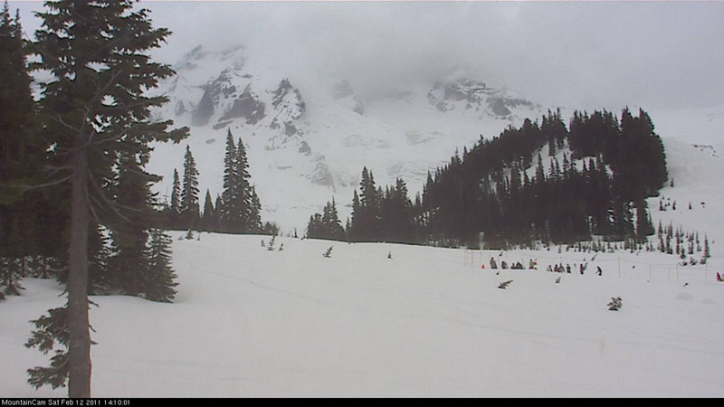
Surprisingly, the upper mountain (up to about 12000 ft) remained in view from Paradise during much of the peak wind period. These three webcam images were captured at 1350, 1400, and 1410 on 12Feb2011, when the wind was continuously above 105 mph and gusted over 150 mph (the clouds fully obscured the view shortly afterwards):
I've often been curious about the anemometers used at NWAC sites, too, including their calibration and whether any altitude (air density) correction is required. Perhaps Mark or Garth from NWAC can answer? (maybe I should email them).
I've often been curious about the anemometers used at NWAC sites, too, including their calibration and whether any altitude (air density) correction is required. Perhaps Mark or Garth from NWAC can answer? (maybe I should email them).
Please Log in or Create an account to join the conversation.
- andyski
- [andyski]
-
- Offline
- Senior Member
-
Less
More
- Posts: 250
- Thank you received: 0
15 Feb 2011 06:25 #197884
by andyski
Replied by andyski on topic Re: Muiricane
Lots of great extreme wind/anemometer info on the Mt. Washington observatory site: www.mountwashington.org/about/visitor/recordwind.php.
The summit station there holds the record for highest recorded surface gust at 231 mph. Unreal.
The summit station there holds the record for highest recorded surface gust at 231 mph. Unreal.
Please Log in or Create an account to join the conversation.
- Garth_Ferber
- [Garth_Ferber]
-
- Offline
- Junior Member
-
Less
More
- Posts: 79
- Thank you received: 0
15 Feb 2011 07:53 #197888
by Garth_Ferber
Replied by Garth_Ferber on topic Re: Muiricane
The wind gauges we use at the NWAC are manufactured by a small local company called Taylor Scientific. Here are photos from the St Helens station. I believe they are fairly accurate for the speeds measured recently at Muir but I'll ask Mark when I see him as I think there are specs available.
First photo is anemometer (wind speed) and second photo is wind vane ( wind direction).
First photo is anemometer (wind speed) and second photo is wind vane ( wind direction).
Please Log in or Create an account to join the conversation.
- Garth_Ferber
- [Garth_Ferber]
-
- Offline
- Junior Member
-
Less
More
- Posts: 79
- Thank you received: 0
15 Feb 2011 08:05 #197889
by Garth_Ferber
Replied by Garth_Ferber on topic Re: Muiricane
I guess I should add the the half circle shaped cups on the anemometer cause the upper part of the anemometer to spin which generates a voltage which is measured by the station datalogger. And that the fin or tail on the vane rotates the upper part of the vane to point into the wind which allows a certain voltage to pass through the vane and be measured by the station datalogger.
Please Log in or Create an account to join the conversation.
- steve_f
- [sfrankovich]
-
- Offline
- New Member
-
Less
More
- Posts: 21
- Thank you received: 0
15 Feb 2011 11:02 #197896
by steve_f
Replied by steve_f on topic Re: Muiricane
It looks like most of Feb. 12 is missing on all of the 10 day telemetry.
2 14 400 14 94 48 57 66 276 1
2 14 300 13 95 49 61 71 276 1
2 14 200 15 94 50 58 65 276 0
2 14 100 15 94 55 59 67 276 0
2 14 0 14 93 50 61 68 276 0
2 13 2300 11 93 52 64 72 276 0
2 13 2200 17 93 44 52 63 276 1
2 13 2100 17 95 42 48 56 276 1
2 13 2000 18 96 37 45 53 276 1
2 13 1900 18 96 38 45 53 276 1
2 13 1800 20 97 41 61 75 266 7
2 13 1700 17 90 50 62 72 247 77
2 13 1600 15 44 0 35 72 251 214
2 13 1500 18 13 0 2 36 250 273
2 13 1400 16 23 0 26 50 245 415
2 13 1300 24 10 28 44 63 251 580
2 13 1200 24 11 35 53 72 246 627
2 13 1100 22 15 21 46 65 247 499
2 13 1000 21 12 20 38 53 248 350
2 13 900 19 17 20 31 49 253 183
2 13 800 17 29 18 31 49 250 30
2 13 700 17 39 12 22 36 253 0
2 13 600 15 94 4 11 23 276 0
2 13 500 12 94 8 23 38 251 0
2 12 400 18 71 67 94 116 244 1
2 12 300 18 68 88 106 122 243 0
2 12 200 18 73 83 104 126 244 0
2 12 100 17 69 73 94 114 248 0
2 12 0 19 44 58 83 100 243 0
2 11 2300 20 31 68 84 103 245 1
2 11 2200 20 80 62 83 101 242 0
2 11 2100 20 81 70 85 109 244 1
2 11 2000 19 91 57 83 100 245 0
2 11 1900 19 96 54 77 93 250 1
2 11 1800 19 96 51 76 95 249 4
2 11 1700 18 95 48 76 92 249 40
2 11 1600 17 92 53 71 87 249 108
2 11 1500 18 87 47 71 87 246 197
2 11 1400 20 91 42 70 85 248 283
2 11 1300 19 93 28 65 83 251 311
2 11 1200 19 27 44 77 104 245 322
2 11 1100 18 33 65 81 95 247 316
2 11 1000 18 49 69 82 97 247 245
2 11 900 17 49 68 79 91 242 122
2 11 800 17 60 57 74 85 243 17
2 11 700 18 40 43 67 85 250 0
2 11 600 18 31 48 63 87 249 0
2 11 500 19 51 32 53 71 247 0
Please Log in or Create an account to join the conversation.
- CascadeClimber
- [CascadeClimber]
-
- Offline
- Junior Member
-
Less
More
- Posts: 90
- Thank you received: 0
16 Feb 2011 09:17 #197927
by CascadeClimber
Replied by CascadeClimber on topic Re: Muiricane
I got to 14k on Rainier on a bluebird day in February a few years ago. Not a cloud in the sky. It got windier and windier above Gib Rock and at 14k I was lifted off the ground and thrown 20+ feet. At that point it was blowing too hard to stand up and we reverse-front pointed back to Gib Rock. The wind was coming out of the north and as soon was we dropped below Camp Comfort, it was calm...and even warm. But we both had large amounts of ice on our faces, eyebrows, etc. I had blistered windburns on my wrists.
And not a wisp of cloud or lenticular. I don't know how hard it was blowing, but I must have totalled around 200 pounds with boots, pons, and gear.
I've also heard that the BBQ grill that used to be at Schurman broke a chain tether and blew away in strong winds years ago.
And not a wisp of cloud or lenticular. I don't know how hard it was blowing, but I must have totalled around 200 pounds with boots, pons, and gear.
I've also heard that the BBQ grill that used to be at Schurman broke a chain tether and blew away in strong winds years ago.
Please Log in or Create an account to join the conversation.
- Amar Andalkar
- [andalkar]
-
- Offline
- Premium Member
-
Less
More
- Posts: 635
- Thank you received: 0
27 Feb 2011 20:49 - 01 Mar 2011 11:45 #198147
by Amar Andalkar
Replied by Amar Andalkar on topic Re: Muiricane
Well, it's been blowing over 100 mph at Muir again, much of the day Sunday and continuing intermittently through Monday into Tuesday, March 1. Monday's maximum gust of 137 mph makes that day the 2nd windiest on record, since the station was installed in 2006.
Northwest Weather and Avalanche Center
Camp Muir, Mt Rainier National Park, Washington
Data also courtesy Mt Rainier National Park
Wind sensors unheated and may rime
MM/DD Hour Temp RH Wind Wind Wind Wind Solar
PST F % Min Avg Max Dir W/m2
10100' 10100' 10100' 10100' 10100' 10100' 10100'
2 27 0 4 67 15 39 70 359 0
2 27 100 3 89 21 40 58 359 0
2 27 200 3 90 26 56 80 359 0
2 27 300 4 90 48 68 86 359 0
2 27 400 3 90 60 73 90 359 0
2 27 500 3 90 37 63 82 359 0
2 27 600 4 90 33 63 81 359 0
2 27 700 4 90 55 69 86 359 3
2 27 800 5 90 50 71 90 359 66
2 27 900 5 91 63 77 91 359 178
2 27 1000 5 90 54 81 98 359 277
2 27 1100 5 90 64 83 100 359 324
2 27 1200 5 91 73 86 103 359 243
2 27 1300 5 90 75 90 101 359 259
2 27 1400 5 90 73 96 110 359 292
2 27 1500 4 90 79 96 111 359 198
2 27 1600 4 90 72 94 119 359 120
2 27 1700 5 90 80 101 120 359 46
2 27 1800 5 91 84 102 116 359 10
2 27 1900 5 91 85 102 128 359 0
2 27 2000 5 91 86 102 115 359 0
2 27 2100 6 91 85 103 112 359 0
2 27 2200 5 91 84 102 116 359 0
2 27 2300 5 91 92 107 128 359 0
2 28 0 6 91 79 104 124 359 0
2 28 100 6 91 94 112 137 359 0
2 28 200 5 91 88 106 131 359 0
2 28 300 5 91 84 103 127 359 0
2 28 400 4 90 62 87 97 359 0
2 28 500 3 90 49 78 102 359 0
2 28 600 2 89 36 59 78 359 0
2 28 700 2 90 50 70 89 359 2
2 28 800 1 89 40 67 97 359 38
2 28 900 1 89 37 67 94 359 113
2 28 1000 0 89 36 60 85 359 208
2 28 1100 1 89 34 72 96 359 271
2 28 1200 1 88 42 65 88 359 312
2 28 1300 2 90 40 69 97 359 312
2 28 1400 2 89 36 71 98 359 310
2 28 1500 3 90 43 63 92 359 279
2 28 1600 1 89 37 75 118 359 172
2 28 1700 2 89 39 67 92 359 85
2 28 1800 2 88 54 78 95 359 16
2 28 1900 0 89 51 78 109 359 0
2 28 2000 2 89 55 89 111 359 0
2 28 2100 2 89 62 82 105 359 0
2 28 2200 3 90 62 83 99 359 0
2 28 2300 2 89 63 82 102 359 0
3 1 0 4 90 60 78 98 359 0
3 1 100 4 91 60 83 105 359 0
3 1 200 3 90 67 91 110 359 0
3 1 300 4 90 62 82 118 359 0
3 1 400 5 91 52 75 97 359 0
3 1 500 7 91 42 69 91 359 0
3 1 600 10 92 40 79 101 359 0
3 1 700 11 93 68 91 107 359 2
3 1 800 9 92 73 91 111 359 36
3 1 900 9 92 67 76 83 359 103
3 1 1000 10 92 55 69 77 359 159
3 1 1100 11 92 58 67 74 359 216
Here's an updated list of days with winds over 100 mph at the Muir telemetry site:
06Sep2006: Muir station installed
06Nov2006: 121 mph (16" of rain in 48 hrs at Paradise, park flooded and closed until May)
29Apr2007: 125 mph
30Apr2007: 100 mph
12Nov2007: 119 mph
26Nov2007: 117 mph
02Dec2007: 111 mph
29Feb2008: 109 mph
03Mar2008: 100 mph
23Mar2008: 131 mph (avg 109 mph)
data missing for most of Oct-Nov-Dec 2008
27Jan2009: 110 mph
07Mar2009: 108 mph
15Mar2009: 126 mph
04May2009: 113 mph
17Oct2009: 106 mph
11Mar2010: 101 mph
20Mar2010: 106 mph
28Mar2010: 100 mph
19May2010: 113 mph
15Nov2010: 111 mph
12Jan2011: 109 mph
07Feb2011: 116 mph
11Feb2011: 109 mph
12Feb2011: 155 mph (avg 132 mph, min 107 mph)
22Feb2011: 109 mph
27Feb2011: 128 mph
28Feb2011: 137 mph (avg 112 mph)
01Mar2011: 118 mph
[size=small](Edited several times to add more wind data for Monday, Tuesday.)[/size]
Please Log in or Create an account to join the conversation.
- garyabrill
- [garyabrill]
-
- Offline
- Senior Member
-
Less
More
- Posts: 464
- Thank you received: 0
28 Feb 2011 21:46 #198221
by garyabrill
Replied by garyabrill on topic Re: Muiricane
Pretty amazing how many hours in a row that the wind gusts exceeded 100mph. Usually these wind events last just an hour or two with strong frontal passage.
I recall some very strong winds one winter a few years back at White Pass with about three different wind events exceeding 100mph and one perhaps in the mid 130's. I am pretty sure at that time it never hit 155 mph.
The most amazing wind damage I ever saw was on the trail from Carbon River cg towards Spray Park in 1982. About a quarter of a mile of the trail was covered with old growth downfall, the biggest pile of which was nearly 30' tall. I guessed that must have been a 180mph gust or so and was probably caused by the freakish convergence of two outburst flows. There was a cyclonic distribution of the downfall.
Please Log in or Create an account to join the conversation.
- Amar Andalkar
- [andalkar]
-
- Offline
- Premium Member
-
Less
More
- Posts: 635
- Thank you received: 0
01 Mar 2011 07:56 - 01 Mar 2011 08:47 #198234
by Amar Andalkar
Replied by Amar Andalkar on topic Re: Muiricane
The forecast now calls for even higher winds on Wednesday, March 2, with predicted free air winds of 90 mph at 10000 ft and and 120 mph at 14000 ft -- the latter is among the highest wind that I can ever recall seeing in the NWS Rainier forecast:
The cause of the high winds? An impressive-looking low pressure system, forecast to rapidly strengthen and head NE towards Vancouver Island. This image from the UW model (www.atmos.washington.edu/mm5rt/) shows expected pressure (i.e. geopotential height), temperature, and winds on the 700 millibar pressure surface (at roughly 10000 ft elevation) on Wednesday morning:
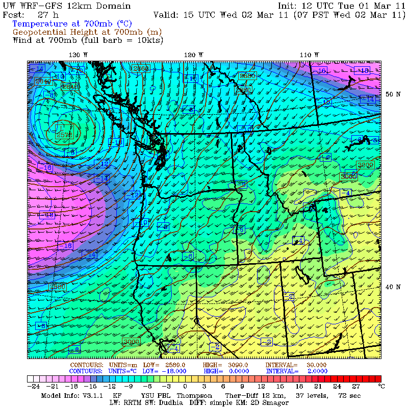
84-hour Loop: www.atmos.washington.edu/~ovens/loops/wx...00t+2011030112//84/3
The actual measured wind at Camp Muir is often much higher than the free air wind, as much as 50% higher or more, due to the wind accelerating as it flows above and around the massive bulk of Mount Rainier. Here is the wind portion of the forecast during the 137 mph event:
and during the earlier 155 mph event:
Both times, average measured winds at Muir exceeded the predicted free-air values for several hours, and peak gusts were about 20% above the average winds.
MOUNT RAINIER RECREATIONAL FORECAST
NATIONAL WEATHER SERVICE SEATTLE WA
428 AM PST TUE MAR 1 2011
SYNOPSIS...A WARM FRONT WILL BRING SNOW TUESDAY AFTERNOON AND TUESDAY NIGHT. A COLD FRONT WILL BRING MORE SNOW AND WIND WEDNESDAY. THE WEATHER PATTERN WILL STAY ACTIVE THURSDAY THROUGH SATURDAY AS ADDITIONAL FRONTS MOVE THROUGH. SUNDAY AND MONDAY WILL SEE A BREAK IN THE ACTIVE WEATHER AS THE STORM TRACK SHIFTS SOUTH.
...WINTER WEATHER ADVISORY IN EFFECT UNTIL 6 AM PST WEDNESDAY...
TUESDAY...SNOW SHOWERS THIS MORNING. RAIN OR SNOW IN THE AFTERNOON. SNOW LEVEL 1500 FEET. SNOW ACCUMULATIONS UP TO 6 INCHES.
TUESDAY NIGHT...SNOW AND RAIN. SNOW LEVEL 3000 FEET. SNOW ACCUMULATIONS UP TO 10 INCHES.
WEDNESDAY...SNOW AND RAIN. WINDY. SNOW LEVEL 3000 FEET. SNOW ACCUMULATIONS UP TO 8 INCHES.
WEDNESDAY NIGHT...SHOWERS. SNOW LEVEL 1500 FEET.
THURSDAY...SNOW SHOWERS.
TEMPERATURE AND WIND FORECASTS FOR SELECTED LOCATIONS.
TUE TUE WED WED THU
NIGHT NIGHT
SUMMIT (14411 FT) -1 1 -8 -14 -13
SW 100 SW 110 SW 120 SW 90 SW 60
CAMP MUIR(10188 FT) 6 18 7 3 3
SW 75 S 75 SW 90 SW 60 SW 40
PARADISE (5420 FT) 30 23 29 18 27
SW 10 SE 10 S 20 S 15 S 5
LONGMIRE (2700 FT) 33 29 34 28 33
CALM CALM S 10 CALM CALM
++ TEMPERATURES AND WIND FOR THE SUMMIT AND CAMP MUIR ARE AVERAGE
CONDITIONS EXPECTED IN THE FREE AIR AT THOSE ELEVATIONS.
The cause of the high winds? An impressive-looking low pressure system, forecast to rapidly strengthen and head NE towards Vancouver Island. This image from the UW model (www.atmos.washington.edu/mm5rt/) shows expected pressure (i.e. geopotential height), temperature, and winds on the 700 millibar pressure surface (at roughly 10000 ft elevation) on Wednesday morning:
84-hour Loop: www.atmos.washington.edu/~ovens/loops/wx...00t+2011030112//84/3
The actual measured wind at Camp Muir is often much higher than the free air wind, as much as 50% higher or more, due to the wind accelerating as it flows above and around the massive bulk of Mount Rainier. Here is the wind portion of the forecast during the 137 mph event:
MOUNT RAINIER RECREATIONAL FORECAST
NATIONAL WEATHER SERVICE SEATTLE WA
415 AM PST MON FEB 28 2011
MON MON TUE TUE WED
NIGHT NIGHT
SUMMIT (14411 FT) -11 -8 -2 3 -6
SW 100 SW 89 SW 68 SW 47 SW 76
CAMP MUIR(10188 FT) 2 3 11 17 9
W 95 SW 35 SW 41 SW 53 SW 62
and during the earlier 155 mph event:
MOUNT RAINIER RECREATIONAL FORECAST
NATIONAL WEATHER SERVICE SEATTLE WA
400 AM PST SAT FEB 12 2011
SAT SAT SUN SUN MON
NIGHT NIGHT
SUMMIT (14411 FT) 7 3 6 4 3
SW 100 W 80 SW 50 SW 60 SW 70
CAMP MUIR(10188 FT) 21 14 20 21 18
SW 100 W 60 SW 40 SW 45 SW 60
Both times, average measured winds at Muir exceeded the predicted free-air values for several hours, and peak gusts were about 20% above the average winds.
Please Log in or Create an account to join the conversation.
- Jim Oker
- [jim_oker]
-
- Offline
- Elite Member
-

Less
More
- Posts: 900
- Thank you received: 0
01 Mar 2011 09:58 #198238
by Jim Oker
Replied by Jim Oker on topic Re: Muiricane
Interesting info in this thread. It's hard not to be reminded of puny little Mt Washington in NH. Just checked the latest from their summit observatory, and I see that they are experiencing fairly typical mid-winter gusts of 100MPH. (
www.mountwashington.org/weather/conditions.php
). Their highest-recorded windspeed was 231MPH.
Please Log in or Create an account to join the conversation.
- garyabrill
- [garyabrill]
-
- Offline
- Senior Member
-
Less
More
- Posts: 464
- Thank you received: 0
02 Mar 2011 10:24 - 02 Mar 2011 10:27 #198301
by garyabrill
Replied by garyabrill on topic Re: Muiricane
Check out the telemetry for Mt. Baker this morning with a wind gust to 116 mph. Baker's telemetry is not particularly great for showing winds aloft and was only in the low 50's max during the wind events of 2/27 to 3/1 at Muir.
Please Log in or Create an account to join the conversation.
- Amar Andalkar
- [andalkar]
-
- Offline
- Premium Member
-
Less
More
- Posts: 635
- Thank you received: 0
02 Mar 2011 23:37 #198363
by Amar Andalkar
Replied by Amar Andalkar on topic Re: Muiricane
The 116 mph gust today is by far the highest recorded at the Mt Baker Ski Area telemetry site, since the wind data was added in January 2008.
Northwest Weather and Avalanche Center
Mt Baker Ski Area, Washington
Wind sensors unheated and may rime
Precip gage appears to be under-recording 2-27-2011
MM/DD Hour Temp Temp RH RH Wind Wind Wind Wind Hour Total 24 Hr Total
PST F F % % Min Avg Max Dir Prec. Prec. Snow Snow
5000' 4210' 5000' 4210' 5000' 5000' 5000' 5000' 4210' 4210' 4210' 4210'
3 2 700 29 32 100 100 6 20 46 188 0.04 0.22 0 174
3 2 800 30 33 100 100 5 26 46 194 0.04 0.26 0 174
3 2 900 31 33 100 99 8 31 62 149 0.08 0.34 1 174
3 2 1000 28 32 100 100 17 64 116 164 0.05 0.39 45 174
3 2 1100 26 29 100 99 23 60 111 207 0.03 0.42 45 174
3 2 1200 26 29 100 97 20 43 73 179 0.02 0.44 45 173
3 2 1300 26 29 100 97 11 33 73 197 0.05 0.49 45 174
3 2 1400 26 29 100 98 12 35 80 207 0.03 0.52 45 174
3 2 1500 24 28 100 92 16 39 67 188 0.01 0.53 -389 174
3 2 1600 23 27 100 89 14 37 65 191 0.00 0.53 -405 173
3 2 1700 22 26 100 93 14 36 59 157 0.00 0.53 -385 173
3 2 1800 21 24 100 93 9 28 56 181 0.01 0.54 -369 173
Here's a list of days with winds over 80 mph at the Mt Baker Ski Area site:
09Jan2008: wind data at 5000' added to telemetry
02Mar2009: 89 mph
05Nov2009: 103 mph
17Nov2009: 88 mph
16Mar2010: 81 mph
12Feb2011: 92 mph
14Feb2011: 94 mph
02Mar2011: 116 mph
The maximum gust of 98 mph at Hurricane Ridge today ties the highest recorded since the 2004-5 season. Note that this telemetry site was moved in the summer of 2007, gaining elevation from 5150 ft to 5260 ft.
Here's a list of days with winds over 80 mph at the Hurricane Ridge sites since the 2004-5 season:
15Nov2004: 98 mph
01Jan2006: 83 mph
04Jan2006: 82 mph
04Feb2006: 83 mph
19Nov2006: 79 mph
summer2007: site moved
12Nov2007: 89 mph
03Dec2007: 86 mph
no winds over 68 mph during 2008-2009 season
11Jan2010: 82 mph
15Jan2010: 81 mph
18Jan2010: 87 mph
19May2010: 83 mph
01Nov2010: 81 mph
24Dec2010: 81 mph
02Mar2011: 98 mph
Winds also hit 90 mph at Mission Ridge (nothing special at this site, which often exceeds 100 mph) and 80 mph at Crystal Mtn, which has been exceeded many times over the past 2 winters. Winds over 80 mph were very uncommon at Crystal though during the previous 5 winters.
Here's a list of days with winds over 80 mph at the Crystal Mountain Ski Area site since the 2004-5 season:
no winds over 72 mph during 2004-2005 season
no winds over 75 mph during 2005-2006 season
13Nov2006: 84 mph
15Dec2006: 85 mph
09Jan2007: 86 mph
03Dec2007: 90 mph
04Jan2009: 81 mph
05Nov2009: 94 mph
09Nov2009: 102 mph
16Nov2009: 115 mph
18Nov2009: 80 mph
19Nov2009: 98 mph
20Nov2009: 107 mph
22Nov2009: 95 mph
06Dec2009: 91 mph
15Jan2010: 83 mph
17Jan2010: 98 mph
18Jan2010: 113 mph
19Jan2010: 96 mph
12Mar2010: 85 mph
29Mar2010: 92 mph
19May2010: 83 mph
15Nov2010: 83 mph
07Dec2010: 89 mph
12Dec2010: 86 mph
14Dec2010: 88 mph
18Dec2010: 91 mph
12Jan2011: 86 mph
16Jan2011: 83 mph
07Feb2011: 84 mph
12Feb2011: 88 mph
28Feb2011: 88 mph
02Mar2011: 80 mph
So what about Camp Muir? The NWS revised their predicted winds for Wednesday downward significantly since the morning of March 1:
And the actual winds at Muir turned out to be a TOTAL disappointment, only reaching 56 mph, which is pathetic compared to the numerous 100+ mph events. That value seems way too low (especially considering that Paradise reached 43 mph), and it could perhaps be a sign of partial riming of the anemometer which prevented recording a true value.
Northwest Weather and Avalanche Center
Mt Baker Ski Area, Washington
Wind sensors unheated and may rime
Precip gage appears to be under-recording 2-27-2011
MM/DD Hour Temp Temp RH RH Wind Wind Wind Wind Hour Total 24 Hr Total
PST F F % % Min Avg Max Dir Prec. Prec. Snow Snow
5000' 4210' 5000' 4210' 5000' 5000' 5000' 5000' 4210' 4210' 4210' 4210'
3 2 700 29 32 100 100 6 20 46 188 0.04 0.22 0 174
3 2 800 30 33 100 100 5 26 46 194 0.04 0.26 0 174
3 2 900 31 33 100 99 8 31 62 149 0.08 0.34 1 174
3 2 1000 28 32 100 100 17 64 116 164 0.05 0.39 45 174
3 2 1100 26 29 100 99 23 60 111 207 0.03 0.42 45 174
3 2 1200 26 29 100 97 20 43 73 179 0.02 0.44 45 173
3 2 1300 26 29 100 97 11 33 73 197 0.05 0.49 45 174
3 2 1400 26 29 100 98 12 35 80 207 0.03 0.52 45 174
3 2 1500 24 28 100 92 16 39 67 188 0.01 0.53 -389 174
3 2 1600 23 27 100 89 14 37 65 191 0.00 0.53 -405 173
3 2 1700 22 26 100 93 14 36 59 157 0.00 0.53 -385 173
3 2 1800 21 24 100 93 9 28 56 181 0.01 0.54 -369 173
Here's a list of days with winds over 80 mph at the Mt Baker Ski Area site:
09Jan2008: wind data at 5000' added to telemetry
02Mar2009: 89 mph
05Nov2009: 103 mph
17Nov2009: 88 mph
16Mar2010: 81 mph
12Feb2011: 92 mph
14Feb2011: 94 mph
02Mar2011: 116 mph
The maximum gust of 98 mph at Hurricane Ridge today ties the highest recorded since the 2004-5 season. Note that this telemetry site was moved in the summer of 2007, gaining elevation from 5150 ft to 5260 ft.
Here's a list of days with winds over 80 mph at the Hurricane Ridge sites since the 2004-5 season:
15Nov2004: 98 mph
01Jan2006: 83 mph
04Jan2006: 82 mph
04Feb2006: 83 mph
19Nov2006: 79 mph
summer2007: site moved
12Nov2007: 89 mph
03Dec2007: 86 mph
no winds over 68 mph during 2008-2009 season
11Jan2010: 82 mph
15Jan2010: 81 mph
18Jan2010: 87 mph
19May2010: 83 mph
01Nov2010: 81 mph
24Dec2010: 81 mph
02Mar2011: 98 mph
Winds also hit 90 mph at Mission Ridge (nothing special at this site, which often exceeds 100 mph) and 80 mph at Crystal Mtn, which has been exceeded many times over the past 2 winters. Winds over 80 mph were very uncommon at Crystal though during the previous 5 winters.
Here's a list of days with winds over 80 mph at the Crystal Mountain Ski Area site since the 2004-5 season:
no winds over 72 mph during 2004-2005 season
no winds over 75 mph during 2005-2006 season
13Nov2006: 84 mph
15Dec2006: 85 mph
09Jan2007: 86 mph
03Dec2007: 90 mph
04Jan2009: 81 mph
05Nov2009: 94 mph
09Nov2009: 102 mph
16Nov2009: 115 mph
18Nov2009: 80 mph
19Nov2009: 98 mph
20Nov2009: 107 mph
22Nov2009: 95 mph
06Dec2009: 91 mph
15Jan2010: 83 mph
17Jan2010: 98 mph
18Jan2010: 113 mph
19Jan2010: 96 mph
12Mar2010: 85 mph
29Mar2010: 92 mph
19May2010: 83 mph
15Nov2010: 83 mph
07Dec2010: 89 mph
12Dec2010: 86 mph
14Dec2010: 88 mph
18Dec2010: 91 mph
12Jan2011: 86 mph
16Jan2011: 83 mph
07Feb2011: 84 mph
12Feb2011: 88 mph
28Feb2011: 88 mph
02Mar2011: 80 mph
So what about Camp Muir? The NWS revised their predicted winds for Wednesday downward significantly since the morning of March 1:
MOUNT RAINIER RECREATIONAL FORECAST
NATIONAL WEATHER SERVICE SEATTLE WA
428 AM PST TUE MAR 1 2011
TEMPERATURE AND WIND FORECASTS FOR SELECTED LOCATIONS.
TUE TUE WED WED THU
NIGHT NIGHT
SUMMIT (14411 FT) -1 1 -8 -14 -13
SW 100 SW 110 SW 120 SW 90 SW 60
CAMP MUIR(10188 FT) 6 18 7 3 3
SW 75 S 75 SW 90 SW 60 SW 40
MOUNT RAINIER RECREATIONAL FORECAST
NATIONAL WEATHER SERVICE SEATTLE WA
251 PM PST TUE MAR 1 2011
TUE WED WED THU
NIGHT NIGHT
SUMMIT (14411 FT) 4 -7 -12 -14
SW 57 SW 78 SW 56 SW 44
CAMP MUIR(10188 FT) 19 7 4 5
S 51 SW 54 SW 43 SW 32
MOUNT RAINIER RECREATIONAL FORECAST
NATIONAL WEATHER SERVICE SEATTLE WA
407 AM PST WED MAR 2 2011
WED WED THU THU FRI
NIGHT NIGHT
SUMMIT (14411 FT) -6 -12 -12 -9 -3
SW 83 SW 48 SW 32 W 42 SW 39
CAMP MUIR(10188 FT) 7 4 7 7 12
SW 60 SW 35 SW 29 W 26 SW 39
And the actual winds at Muir turned out to be a TOTAL disappointment, only reaching 56 mph, which is pathetic compared to the numerous 100+ mph events. That value seems way too low (especially considering that Paradise reached 43 mph), and it could perhaps be a sign of partial riming of the anemometer which prevented recording a true value.
Please Log in or Create an account to join the conversation.
- garyabrill
- [garyabrill]
-
- Offline
- Senior Member
-
Less
More
- Posts: 464
- Thank you received: 0
03 Mar 2011 15:00 #198394
by garyabrill
I had the same thought about rime-caused friction on the anenometer when I saw the telemetry for Muir. It seemed to have trouble getting above 50 mph and was nearly the same for a few hours around the time of the peak winds.
Replied by garyabrill on topic Re: Muiricane
Muir? The NWS revised their predicted winds for Wednesday downward significantly since the morning of March 1:
And the actual winds at Muir turned out to be a TOTAL disappointment, only reaching 56 mph, which is pathetic compared to the numerous 100+ mph events. That value seems way too low (especially considering that Paradise reached 43 mph), and it could perhaps be a sign of partial riming of the anemometer which prevented recording a true value.
I had the same thought about rime-caused friction on the anenometer when I saw the telemetry for Muir. It seemed to have trouble getting above 50 mph and was nearly the same for a few hours around the time of the peak winds.
Please Log in or Create an account to join the conversation.
- garyabrill
- [garyabrill]
-
- Offline
- Senior Member
-
Less
More
- Posts: 464
- Thank you received: 0
11 Mar 2011 15:11 #198790
by garyabrill
Replied by garyabrill on topic Re: Muiricane
Don't give up on Mission Ridge yet, they are still in the running with a nice 134 mph gust on 3/10: www.nwac.us/weatherdata/missionridge/10day/
Please Log in or Create an account to join the conversation.
- aaron_wright
- [aaron_wright]
-
- Offline
- Senior Member
-
Less
More
- Posts: 429
- Thank you received: 0
11 Mar 2011 16:14 #198795
by aaron_wright
Replied by aaron_wright on topic Re: Muiricane
The effects of the wind observed at mission ridge today were amazing. Really cool sastrugi, huge difts(8-10') in some spots, very large cornices and a cat track that I had skied on at around 1330 yesterday was completely gone, what had once been a cat track on a steep hillside was now just a steep slope. The uphill cut on the cat track was probably 10-15' the day before.Don't give up on Mission Ridge yet, they are still in the running with a nice 134 mph gust on 3/10: www.nwac.us/weatherdata/missionridge/10day/
Please Log in or Create an account to join the conversation.
- garyabrill
- [garyabrill]
-
- Offline
- Senior Member
-
Less
More
- Posts: 464
- Thank you received: 0
20 Mar 2011 13:42 #199058
by garyabrill
Replied by garyabrill on topic Re: Muiricane
Aaaaahhhhh....spring, a nice, soothing northerly freshet this morning. Rainier, Baker, Alpental, and especially Mission and Crystal: www.nwac.us/weatherdata/crystalskiarea/10day/
Glad I didn't get out there today, afterall. None of my partners were up for an "adventure". So much for the 4th aspect until snows return.
Glad I didn't get out there today, afterall. None of my partners were up for an "adventure". So much for the 4th aspect until snows return.
Please Log in or Create an account to join the conversation.