Dec 18, Paradise Pow - Vid
12/15/10
WA Cascades West Slopes South (Mt Rainier)
2670
7
Sorry for the vague title, but not sure of the name of the area we skied. If you can identify the area in the attached pic for me, that'd be awesome. The pic was taken from Mazama ridge, looking towards Rainier & Pan Point.(maybe Golden gate area??). Regardless, it was a pretty sweet line.
I arrived back in Seattle Friday a little before midnight after the better part of the week in Chicago to get up at 530am to pack and pick up Roman to go ski the Tatoosh. We arrive around 830 to find out the road to paradise wouldnt open til 11. I'm kicking myself for not getting more sleep and frustrated cause I cant understand why the road is not open, how long does it take to clear 3inches of snow? (there weren't down trees). As the hours ticked by, we abandoned our plan for the Tatoosh, settled on "Ol' Reliable" Paradise.
We skinned up from the Pardise parking lot, and broke trail to the area I don't know the name for. As we gained elevation, the wind became quite strong. There was a firm crust about 6-12 inches down, the poles punched through, but the skis did not. The higher the elevation, the thicker the crust. ~12" thick where we dug a miny pit before starting our 1st run.
The 1st run of the day was the best. We followed that up with 2 runs on Mazama Ridge. On our 2nd run we ran into Robie and crew shredding an open slope. The 3rd line was through tighter trees. The snow in all three areas was stable, but Mazama was much more protected from the wind. We had fresh untracked snow for all except for part of the last run
Below is a link to video of the day:
http://www.thealpineobsession.com/2010-ski-videos.html
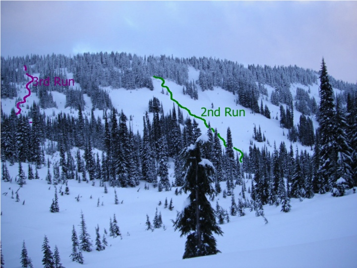
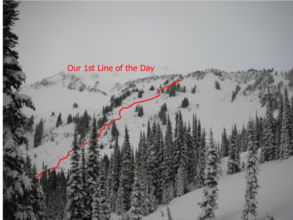
Nice meeting you ,Ist picture is Bundy's
2nd run is what we have always called "The Avalanche slope "
3rd run is Charle's Run
To the north of Charles is the area we call "The Golf Course "
2nd run is what we have always called "The Avalanche slope "
3rd run is Charle's Run
To the north of Charles is the area we call "The Golf Course "
Thanks Robie, Nice to meet you as well.
For some reason I thought Bundy's was a steeper line to the lookers left (not in the photo), that emptied into the road. Learn something new every day.
For some reason I thought Bundy's was a steeper line to the lookers left (not in the photo), that emptied into the road. Learn something new every day.
Most of the place/run names around paradise we use today were put there by current generation skiers. To name a few Ed Straus,Gary Vogt ,Ron Jarvis ,Dorothea Driggers,Andy and Regine I'd really be curious to hear the the same places names by skiers from the 20s 30s 40s 50s etc.
Devil's Dip comes to mind as a very Old name. Perhaps Lowell Skoog has more info.
Gary Vogt has what we call the Rosetta stone map he put together which shows most of the names.
Devil's Dip comes to mind as a very Old name. Perhaps Lowell Skoog has more info.
Gary Vogt has what we call the Rosetta stone map he put together which shows most of the names.
Great video you guys. Also, nice to see Ron & Jeanette do a cameo appearance right there at the end of the video, too ;>)
Rusty ,You sure are alert to catch that it was Ron and Mad dog.Thier disguises threw me off.
not a big fan of helmet cams but the brew cam footage was great!
not a big fan of helmet cams but the brew cam footage was great!
author=Pierce link=topic=18520.msg78421#msg78421 date=1292797753]
... We arrive around 830 to find out the road to paradise wouldnt open til 11. I'm kicking myself for not getting more sleep and frustrated cause I cant understand why the road is not open, how long does it take to clear 3inches of snow? (there weren't down trees).
We had 50-70 mph winds Friday night; a big old-growth tree fell across the road to Paradise not 1/4 mile from the entrance station--right where you can see the Nisqually; park guys cut up the tree and threw the bole and root wad into the river. I have no idea whether or not there were additional trees across the road. You must have seen some of the carnage from Tahoma Woods to the Park, too. We were without power for about 24 hours. The big wind knocked the power out for the second time about 2 a.m. Sat morning.
author=acarey link=topic=18520.msg78533#msg78533 date=1292900117]
We had 50-70 mph winds Friday night; a big old-growth tree fell across the road to Paradise not 1/4 mile from the entrance station--right where you can see the Nisqually; park guys cut up the tree and threw the bole and root wad into the river. I have no idea whether or not there were additional trees across the road. You must have seen some of the carnage from Tahoma Woods to the Park, too. We were without power for about 24 hours. The big wind knocked the power out for the second time about 2 a.m. Sat morning.
We saw the wind carnage as we approached the park. I asked the Ranger at Longmire if there were trees down on the road to paradise and if they'd be opening the road? She replied, there were no trees down from Longmire to Paradise, and they'd be opening the road, so we eagerly awaited the road opening.
@ Robie - "Brewcam" - I like that term
@ Rusty - Thanks.
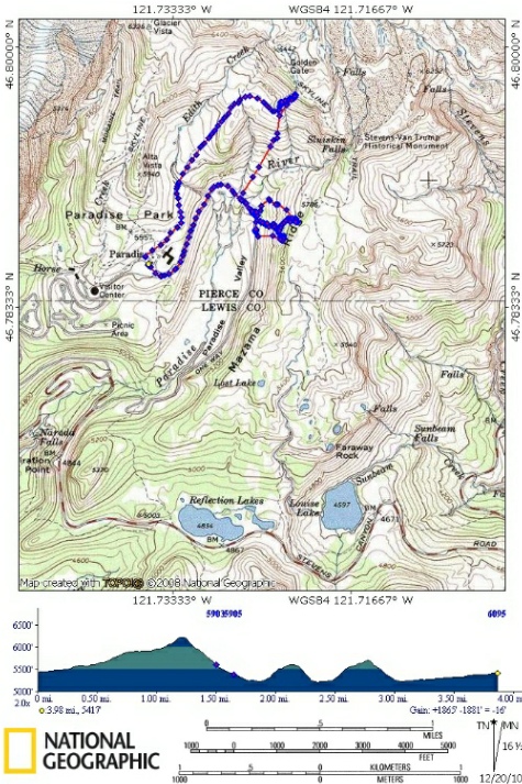
Attached is the our GPS track from the day on a Topo map. The uptrack has the tightly packed data points, downtrack are spaced. Elevation by mile at the bottom.
Reply to this TR
Please login first: