July 11, 2010, Eldorado Peak
7/11/10
WA Cascades West Slopes North (Mt Baker)
11974
13

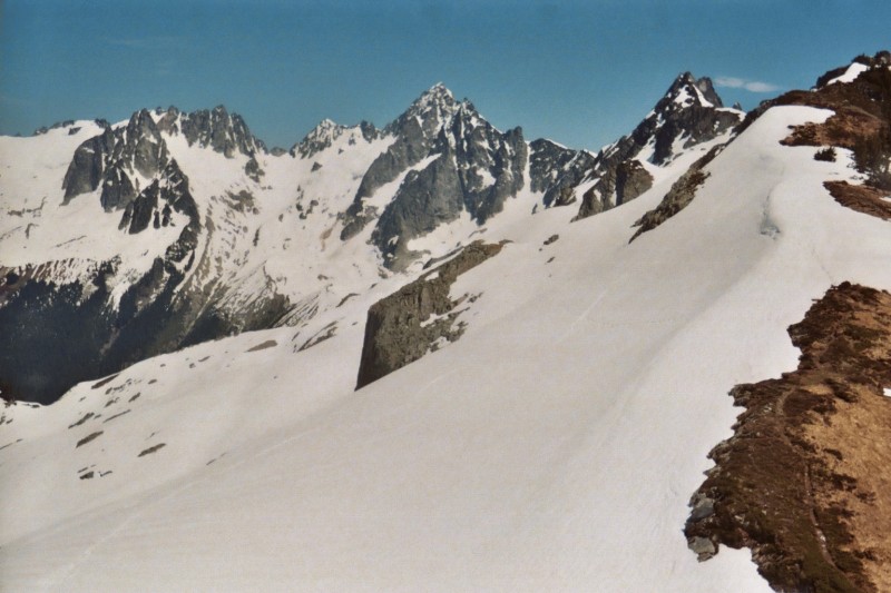
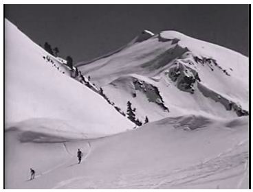
After having to work on the first beautiful Saturday of the summer, I found myself without a partner or plan for Sunday. I decided to head for an old favorite, Eldorado Peak. I've been curious about the early ski trips by Dwight Watson in this area, so I took a detour on the normal Eldorado Glacier approach, swinging far to the left to the southwest ridge of the peak. This area was the high point of Watson's trips in the late 1930s from Sibley Pass, a place he called the "ridge of wonders." One of his pictures, now at the University of Washington, can be seen here.
It was a scenic detour, with unusual views of Eldorado (see above) and the rim of Marble Creek. After following the ridge a while, I crossed the Inspiration Glacier back toward the normal climbing route. I saw a party of four climbers heading home from the peak, the only other people around. I skied to the summit, which was sharper than I've seen in recent years. If my records are correct, this was my 17th ascent of Eldorado since 1978, making it my favorite peak on the planet. I never get tired of this place.

You are, The Man!
The first photo is beautiful. Looks like a bit of a breeze in your second photo.
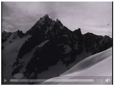
I've excerpted most of Dwight Watson's 1938 movie of skiing near Eldorado Peak on the following web page:
http://mountaineers.org/history/notes/movie/dw-1938-nwskiing.html
Eldorado is the third video clip on this page. My trip on Sunday failed to satisfy my curiosity about Watson's 1938 ski trip. I still don't know where a lot of those scenes were filmed. Someday I'm going to have to repeat the route from Sibley Pass and try to piece together where he went. That'll be a good excuse to ski Eldorado Peak yet again.
Looks like an outstanding trip. I was hoping that you could indulge me with a little trip beta as far as where is the skiable snow line and snow quality, thanks.
Matt
Matt
Those movies are very high quality.
My connection is very slow right now so I could only view the early part of the clip.
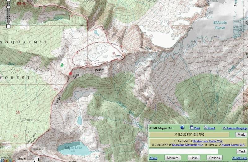
However, some of the views appear to be showing the group skiing either side of the ridge just west of the Triad, near point 6804 on the ACME mapper. The snowfields and glaciers that drain into the "north (or west) fork of Sibley Creek.
To me it looks like they were skiing both the north slopes (with the given views of Eldorado) and the south aspects as well (with the nice views of Johannesburg). Some of the next views seem closer to where you were, maybe just into the Triad or between the Triad and Eldorado.
That "north fork drainage is something that I explored a few years ago. I had done HLP a bunch of times and always wondered what the slopes north of that ridge held, so one day I climbed the blueberry/avalanche slopes to a small bowl that heads up onto the peak just east of the pass. Couldn't see much so I traversed through a small ridge/divide and upon cresting that the whole world seemed to open up for me. It remains my favorite "stash". I call it that, because I saw no evidence of any travel in that area and never have seen reports on it posted here. I tried to head up there with my son last year, but the blueberry slopes seemed more demanding and it slowed us enough to make us only bag the small peak framing the Sibley Pass. I want to go back with him this year, but many conflicts in time are making that difficult.
I understand that HLP trail/Sibley Pass is one approach to Eldorado, but my guess is that approach probably holds onto the south slopes of that ridge and the Triad.
In any case as any map would indicate, the slopes are great to explore all the way high up onto the Triad. This year the views from HLP indicated still a low snow level on the south facing slopes off of that ridge and some great looking skiing. My guess is those are some of the shots in the clip.
I will look at the clip in more detail when I get a chance. I may post some photos from my trip there to see if they match at all. Only problem is that I forgot my digital so they are few and poor quality convenience store camera photos.
Alan
My connection is very slow right now so I could only view the early part of the clip.
However, some of the views appear to be showing the group skiing either side of the ridge just west of the Triad, near point 6804 on the ACME mapper. The snowfields and glaciers that drain into the "north (or west) fork of Sibley Creek.
To me it looks like they were skiing both the north slopes (with the given views of Eldorado) and the south aspects as well (with the nice views of Johannesburg). Some of the next views seem closer to where you were, maybe just into the Triad or between the Triad and Eldorado.
That "north fork drainage is something that I explored a few years ago. I had done HLP a bunch of times and always wondered what the slopes north of that ridge held, so one day I climbed the blueberry/avalanche slopes to a small bowl that heads up onto the peak just east of the pass. Couldn't see much so I traversed through a small ridge/divide and upon cresting that the whole world seemed to open up for me. It remains my favorite "stash". I call it that, because I saw no evidence of any travel in that area and never have seen reports on it posted here. I tried to head up there with my son last year, but the blueberry slopes seemed more demanding and it slowed us enough to make us only bag the small peak framing the Sibley Pass. I want to go back with him this year, but many conflicts in time are making that difficult.
I understand that HLP trail/Sibley Pass is one approach to Eldorado, but my guess is that approach probably holds onto the south slopes of that ridge and the Triad.
In any case as any map would indicate, the slopes are great to explore all the way high up onto the Triad. This year the views from HLP indicated still a low snow level on the south facing slopes off of that ridge and some great looking skiing. My guess is those are some of the shots in the clip.
I will look at the clip in more detail when I get a chance. I may post some photos from my trip there to see if they match at all. Only problem is that I forgot my digital so they are few and poor quality convenience store camera photos.
Alan
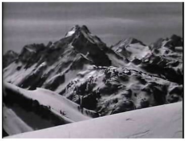
I was able to review my photos and review the rest of the film.
They skied exactly where I have described, probable including areas east of the Triad and up onto Eldorado itself in the southern facing drainages.
The angle of this shot is from ridgeline just near the small peak framing the east of Sibley Pass. Imagine their shot taken almost anywhere on the same line as this shot is looking. My camera may have had a wider field of view, but theirs was likely a narrow field lens and I would suspect they were closer to the Triad as well.
Here is a view towards Johannesburg Mtn. from the same area.
Taking parallax into account and using the sinuous arm coming off of J. Mtn. I would guess that they were a little east of where I stood to take my photo. Note, I am standing real close to the top of the little summit east of Sibley Pass. Therefore they could not have been as far east as the Triad on that photo.
(Other shots later on in the film clearly show them to be east of the Triad, in my opinion, so considering that they were skiing north facing slopes and south facing slopes all the way from Sibley Pass to Eldorado I would have to say them guys has legs! Was this movie from one day of skiing?)
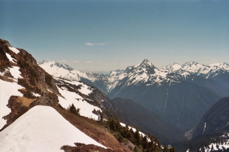
This shot is from the area just at the bottom of the little bowl north west of the peak east of Sibley Pass. Probably taken near the green spot on the map. The shot of Johannesburg I took was where the red spot is.
It is looking past Sibley Pass (actually below the level of the foreground) and onto Hidden Lake Peak. You can only see the true summit of HLP from this aspect.
It is clear they were skiing this very early season. Nice weather.
Alan
(Got it!, finally.)
Marcus, I had named the files by a number and upon changing the file names to letters it worked.)
author=BigSnow link=topic=17158.msg72238#msg72238 date=1279149881]
Other shots later on in the film clearly show them to be east of the Triad, in my opinion, so considering that they were skiing north facing slopes and south facing slopes all the way from Sibley Pass to Eldorado I would have to say them guys has legs! Was this movie from one day of skiing?
I've recorded my conclusions about Dwight Watson's early ski trips to Eldorado here:
http://alpenglow.org/ski-history/notes/ms/dw-scrapbook.html#dw-scrapbook-eldo
Watson's scrapbook describes only one trip that made it beyond The Triad to the slopes of Eldorado itself. I believe it was on May 15, 1938. (All his trips approached the area from Sibley Creek because the Cascade River road ended near that point in the 1930s.) He describes the trip in his scrapbook here:
http://alpenglow.org/ski-history/notes/ms/dw-scrapbook.html#dw-scrapbook-p433
"After arranging packs for a trip to El Dorado peak we were off at six and the weather looked grand and encouraging. We had a movie camera along and although it was our first experience for fifteen years they all came out happily--splendid and the action fast and interesting. Climbing the huge snow slope above the basin we trekked to a high pass, the only feasible route to El Dorado for the country was full of cliffs of tremendous height. Ski shots were obtained along the way and then the drop down a steep icy slope dangerous and skiddy. It was all done without mishap and soon the final basin was not far away. It seemed like a long climb to the east and the pass over the ridge for a grand view of Inspiration glacier, Boston, Buckner, Cascade pass, an unnamed peak each south and north of the pass both unclimbed and both providing thrilling exercise of doubtful success. It is noon as we peer over the vertical cliffs at the basin below El Dorado shoot a few movies and start back for home."
It's remarkable that these were the first movies he had made in 15 years. He was a talented photographer. The route they took is well known by climbers approaching Eldorado from Sibley Pass. You follow the north side of the ridge until just west of The Triad, then cross a notch and drop down a bit before traversing the south flank. I've done it several times, including once on skis, but I took the fastest way, well below the ridge. From his movies, it appears that Watson's party climbed up to the ridge at several places and goofed around taking movies. It's those specific locations that I would really enjoy finding.
Those guys definitely had legs!
author=BigSnow link=topic=17158.msg72240#msg72240 date=1279151171]
(sorry, but for some reasons no matter what I do I cannot post these two images.) I keep getting an error stating that the files I am attaching have the same name of files I have already uploaded. I will try later.
Rename the files and try again -- if the upload was interrupted there's a placeholder with the original name that doesn't allow the attachment to overwrite it.
author=Glorificus Adventum link=topic=17158.msg72229#msg72229 date=1279135608]
Looks like an outstanding trip. I was hoping that you could indulge me with a little trip beta as far as where is the skiable snow line and snow quality, thanks.
I encountered skiable snow just above the final band of stunted evergreens above the talus slopes--about 5600ft I think. Except for the ridge crossing into Roush Creek basin, the snow was continuous from there to the summit. The snow was a little slow--not fast corn snow--but I still enjoyed it. Certainly better than walking. For me just being up there was the main reward.
Also, there is now an excellent log crossing the Cascade River, close to the parking lot (down-stream) and clearly visible from the road. I suspect that the Park Service built this crossing (the logs were cut by a huge chainsaw) after a climber almost drowned crossing the river a few years ago. It's a piece of cake compared to years past.
Lowell,
I read your assessment and quite agree with what you say.
The traverse on the north side of the ridge being the route makes sense to me as it is fairly good terrain to move efficiently until the Triad. I have no idea how the south side of the ridge would work, but my view of it from HLP this year would suggest that it would go very well with the good snow cover it had several weeks ago and of course when they were taping. It looks to me like they skied both sides of the ridge along several sections between Sibley Pass and the Triad and beyond.
When I was there I found parts of the ridge crest quite easy travel with a goat trail. I did not travel along it all the way to the necessary drop to the south near the Triad.
In order to find where they made all those shots I would suggest a higher traverse so that you can poke your head over from time-to-time and see. Maybe carrying a couple of photos of screenshots from the video clip that include distant landmarks will help you confirm. As an example, there was one shot with Johannesburg in the distance that clearly showed a much more easterly aspect that the ones I showed above. You could see some of the high glaciers on the upper slopes of Johannesburg. They were probably high on the Eldorado glacier near the Inspiration glacier for that. You may be able to compare some photos that you have with theirs. Also distant features aligned in a screenshot if marked on a map can be straight lined on a map pretty accurately.
Alan
author=BigSnow link=topic=17158.msg72250#msg72250 date=1279169752]
I read your assessment and quite agree with what you say.
My notes about Dwight Watson's Eldorado trips are almost absurdly detailed. But I went to that effort because I was disproving the idea that Watson had been the first person to make a ski ascent (or ski-assisted climb) of Eldorado Peak. I felt sort of sad doing this, because I'm a big fan of his, not that it would have mattered to him. Dwight Watson had no interest in claiming firsts.
I consider Dwight Watson to be the father of backcountry skiing in the North Cascades. His explorations in the Eldorado Peak area are an important part of his legacy. His films influenced people like Joe and Joan Firey. I credit the Fireys and their friends with completing the ski conquest of Eldorado in the late 1950s, after the Cascade River road was extended. The Fireys popularized the Eldorado Creek approach that we use today.
Watson's films are also a huge part of his legacy. I'm still working to achieve long-term preservation of them, as I described here:
http://www.turns-all-year.com/skiing_snowboarding/trip_reports/index.php?topic=16864.0
Reply to this TR
Please login first: