July 11, 2010, Mt Hood, Snowdome + Sunshine Route
7/11/10
OR Mt Hood
9455
3
Following the previous day's trip (
Sunrise on the north side of Mount Hood, from the closed Cloud Cap Inn just above the campground.
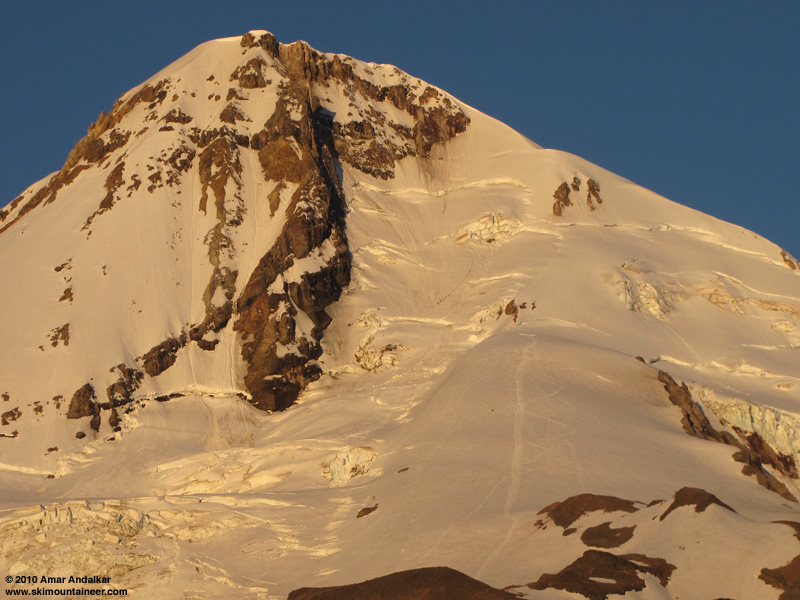
Zoomed version of previous photo, showing Eliot Glacier, Snowdome, the Sunshine Route, and Coe Glacier.
Morning dawned clear and beautiful, with an exceptional view of rosy colors on the mountain, and a refreshing NW breeze. We were on our way up the Timberline Trail by 6:45am, carrying skis and boots on the pack along with glacier gear and helmets. We headed up the branch along the crest of the Eliot Glacier moraine, looking for any easy way down onto the toe of the glacier. The former route of the Timberline Trail down the moraine appears to have been obliterated by the Forest Service within the past couple of years (it still existed the last time I was here in 2007, after the November 2006 floods which destroyed the former trail crossing of Eliot Creek). Since we could not find the descent trail, we continued up the moraine to around 7100 ft, where the moraine steepens and we were forced to descend about 150 vert of loose moraine to the edge of the continuous snow on the mostly rock-covered lower Eliot Glacier.
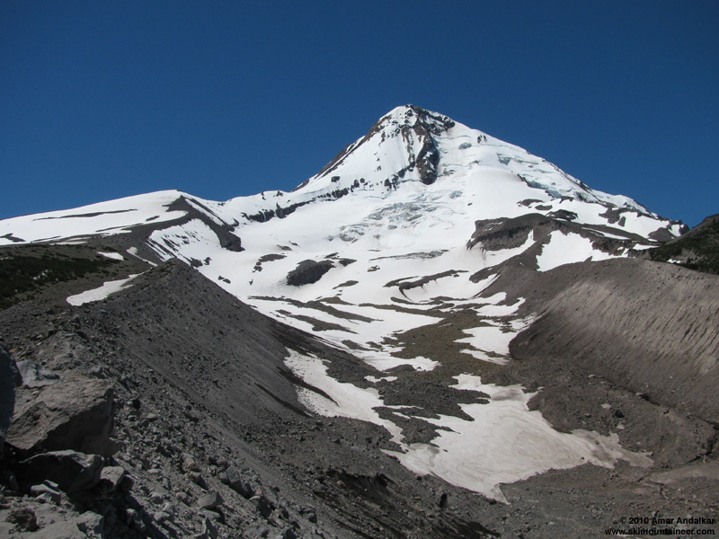
Looking up the Eliot Glacier from the eastern moraine (view on the hike out, around noon).
Skinned from here, making easy progress on the sun-softened corn snow, with minimal crevasse hazard on the nearly-flat glacier. Then we followed a skin track up the steep slope to the right of the icefall to reach Snowdome, and continued up to about 9600 ft beside the first large bergschrund, where the face steepens considerably and the upper Sunshine Route begins. A bootpack from a previous climbing party headed steeply upward about 200 ft, before traversing far right between a pair of long bergschrunds, and eventually climbing another short steep face to reach Cathedral Ridge. No ski tracks were visible above Snowdome though. Snow conditions on Snowdome had deteriorated with elevation though, going from well-consolidated corn below 9000 ft to increasingly unconsolidated mush above that, which did not bode well for the upper face.
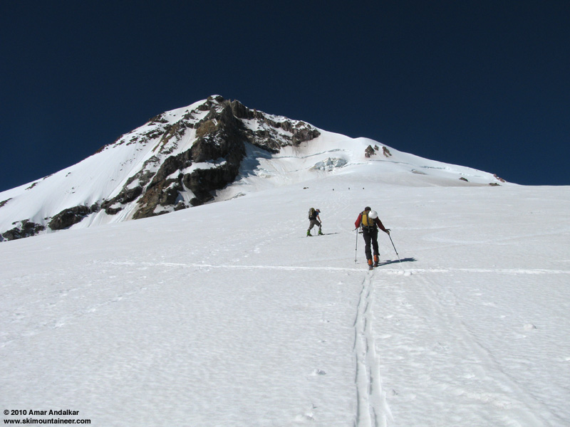
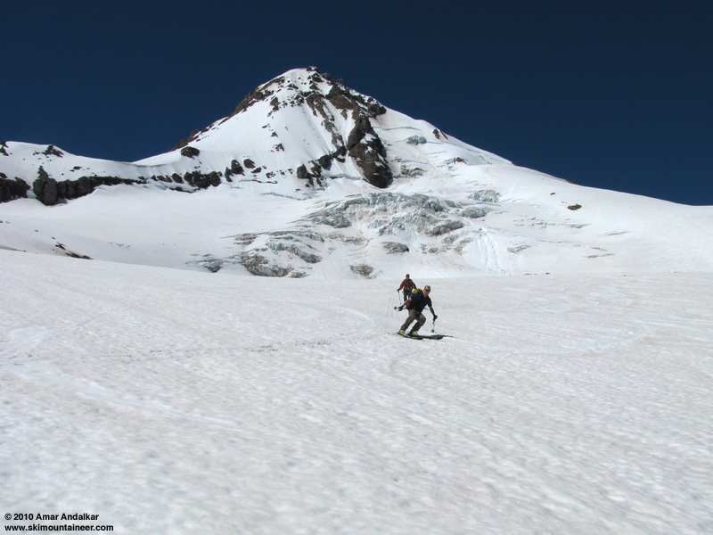
Skinning up Snowdome.
Took a break to eat and gear up beside the bergschrund. Switched to crampons on foot at this point and donned our harnesses just in case, then headed up the bootpack. Soon we were postholing crotch-deep in the mush, followed by a 30 ft stretch of firm 45-degree water ice past the first rocks, and then more crotch-deep postholing above that. Not fun at all, the snow conditions were awful for climbing, and would probably be downright dangerous for skiing, with unpredictable deep mush on steep slopes exposed above gaping open bergschrunds. Just not worth the risk. It was 11am, and time to pull the plug and ski down.

Skiing down past the schrund, just below our 9800 ft high point.
We carefully avoided the ice and negotiated the mush above the schrund, then carved deep trenches down the upper portion of Snowdome.
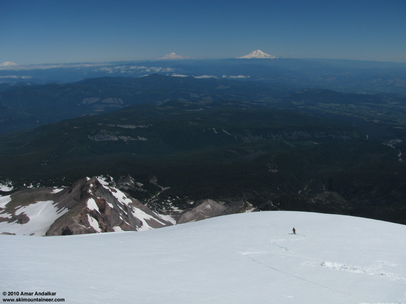
Carving trenches on the upper Snowdome, with Mounts Saint Helens, Rainier, and Adams in the distance.
As expected from the ascent, ski conditions improved dramatically below 9000 ft, with sweet soft smooth corn providing excellent turns. Snow conditions remained good all the way down Snowdome and the steep slopes down onto the Eliot Glacier.

Sweet corn on the lower Snowdome.
Sweet corn on the Eliot Glacier.
The proper exit trail from Eliot Glacier up onto the moraine was easy to spot now looking from above, with it not hidden in the dark shadows of early morning. We skied down directly to where it meets the snow at about 6800 ft. As we changed over from ski boots to hiking shoes, we were surprised to spot Stephanie and Lander hiking along the moraine above, and they soon joined us at the glacier's edge.

Lander Brown enjoying the corn on the Eliot Glacier, too.
The trail up the moraine here appears to be well-constructed, and is marked by a man-sized cairn where it joins the trail along the moraine crest. (I tried to search online, including the Mt Hood NF website, for any information about this trail, but could find none. Does anyone know if this is newly improved? Part of a new higher Timberline Trail crossing? Or is it just a longstanding climber's trail?) A warm hike up the 200 vert, followed by a scenic stroll down the moraine crest cooled by the welcome NW breeze, brought us back to the trailhead just after noon.
A satisfying day despite not making the summit, with very good skiing in a stunning location. About 4400 ft of gain for 3000 vert of turns, mostly on nice corn. The north side of Mount Hood is far more scenic than the south, and has always been a fine skiing or hiking destination every time I've visited.
Sunrise on the north side of Mount Hood, from the closed Cloud Cap Inn just above the campground.
Zoomed version of previous photo, showing Eliot Glacier, Snowdome, the Sunshine Route, and Coe Glacier.
Morning dawned clear and beautiful, with an exceptional view of rosy colors on the mountain, and a refreshing NW breeze. We were on our way up the Timberline Trail by 6:45am, carrying skis and boots on the pack along with glacier gear and helmets. We headed up the branch along the crest of the Eliot Glacier moraine, looking for any easy way down onto the toe of the glacier. The former route of the Timberline Trail down the moraine appears to have been obliterated by the Forest Service within the past couple of years (it still existed the last time I was here in 2007, after the November 2006 floods which destroyed the former trail crossing of Eliot Creek). Since we could not find the descent trail, we continued up the moraine to around 7100 ft, where the moraine steepens and we were forced to descend about 150 vert of loose moraine to the edge of the continuous snow on the mostly rock-covered lower Eliot Glacier.
Looking up the Eliot Glacier from the eastern moraine (view on the hike out, around noon).
Skinned from here, making easy progress on the sun-softened corn snow, with minimal crevasse hazard on the nearly-flat glacier. Then we followed a skin track up the steep slope to the right of the icefall to reach Snowdome, and continued up to about 9600 ft beside the first large bergschrund, where the face steepens considerably and the upper Sunshine Route begins. A bootpack from a previous climbing party headed steeply upward about 200 ft, before traversing far right between a pair of long bergschrunds, and eventually climbing another short steep face to reach Cathedral Ridge. No ski tracks were visible above Snowdome though. Snow conditions on Snowdome had deteriorated with elevation though, going from well-consolidated corn below 9000 ft to increasingly unconsolidated mush above that, which did not bode well for the upper face.
Skinning up Snowdome.
Took a break to eat and gear up beside the bergschrund. Switched to crampons on foot at this point and donned our harnesses just in case, then headed up the bootpack. Soon we were postholing crotch-deep in the mush, followed by a 30 ft stretch of firm 45-degree water ice past the first rocks, and then more crotch-deep postholing above that. Not fun at all, the snow conditions were awful for climbing, and would probably be downright dangerous for skiing, with unpredictable deep mush on steep slopes exposed above gaping open bergschrunds. Just not worth the risk. It was 11am, and time to pull the plug and ski down.
Skiing down past the schrund, just below our 9800 ft high point.
We carefully avoided the ice and negotiated the mush above the schrund, then carved deep trenches down the upper portion of Snowdome.
Carving trenches on the upper Snowdome, with Mounts Saint Helens, Rainier, and Adams in the distance.
As expected from the ascent, ski conditions improved dramatically below 9000 ft, with sweet soft smooth corn providing excellent turns. Snow conditions remained good all the way down Snowdome and the steep slopes down onto the Eliot Glacier.
Sweet corn on the lower Snowdome.
Sweet corn on the Eliot Glacier.
The proper exit trail from Eliot Glacier up onto the moraine was easy to spot now looking from above, with it not hidden in the dark shadows of early morning. We skied down directly to where it meets the snow at about 6800 ft. As we changed over from ski boots to hiking shoes, we were surprised to spot Stephanie and Lander hiking along the moraine above, and they soon joined us at the glacier's edge.
Lander Brown enjoying the corn on the Eliot Glacier, too.
The trail up the moraine here appears to be well-constructed, and is marked by a man-sized cairn where it joins the trail along the moraine crest. (I tried to search online, including the Mt Hood NF website, for any information about this trail, but could find none. Does anyone know if this is newly improved? Part of a new higher Timberline Trail crossing? Or is it just a longstanding climber's trail?) A warm hike up the 200 vert, followed by a scenic stroll down the moraine crest cooled by the welcome NW breeze, brought us back to the trailhead just after noon.
A satisfying day despite not making the summit, with very good skiing in a stunning location. About 4400 ft of gain for 3000 vert of turns, mostly on nice corn. The north side of Mount Hood is far more scenic than the south, and has always been a fine skiing or hiking destination every time I've visited.
Nice report. We (stoudema and myself) were up there Friday night and Saturday morning and put down some of the tracks on the dome (two reports were posted over the weekend). A rather large climbing party put in the bootpack when they summited early Saturday morning and they were breaking down their camp at the top of the dome when we arrived at around 0930. We contemplated going higher up the Sunshine, but having ditched our glacier gear at the base of Snowdome in exchange for lighter packs and faster travel, it really was not a viable option. Besides, the conditions were nearly perfect on our descent and we probably would've experienced the same sketchy conditions above 9600' that you did. Have to admit that the Sunshine Route looked pretty good for this time of year.
The trail up the moraine was there two summers ago for sure when we last skied Snowdome, and I think it is visible in some older photos (2004 or 2005ish, perhaps?). We never used the high route until the old route decided to relocate somewhere below Wallalute Falls. The lack of a lower crossing has made skiing the Langille Bowls a major undertaking.
The trail up the moraine was there two summers ago for sure when we last skied Snowdome, and I think it is visible in some older photos (2004 or 2005ish, perhaps?). We never used the high route until the old route decided to relocate somewhere below Wallalute Falls. The lack of a lower crossing has made skiing the Langille Bowls a major undertaking.
author=loofus link=topic=17157.msg72201#msg72201 date=1279059657]
The lack of a lower crossing has made skiing the Langille Bowls a major undertaking.
This is true. I have heard rumor of a lower crossing, but have yet to find it. Maybe it's down below treeline? Nice report and photos - the snow sure was nice on the Dome for this time of year, even if a bit unconsolidated.
Great photos and TR. I remember seeing the trail off the moraine in our July 2006 ski trip up the Cooper Spur. A few years earlier we used the trail when Jill and I were heading for Snowdome.
Reply to this TR
Please login first: