May 28-30, 2010, Hart's Pass, N Cascades
5/28/10
3632
7
Cascade Backcountry Ski Patrol members Mark (me) and Jonathan headed to the N Cascades. I wanted to do a route I spotted the previous year.
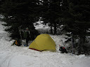
The road was blocked at Dead Horse Point (3700') by a large rock too big for the two of us to move. After some debate we decided to park and hike in anyway. After the rock the road was perfectly drivable for another 2 miles until a deep water cut at 4500'. There was significant snow on the road not far beyond that, and we put our skis on at about 3 miles from the car and 5000'. This was significantly shorter than where we drove to in 2009. We camped at Hart's Pass (6200').
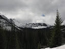
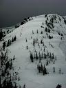
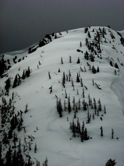
Saturday we left camp at a leisurely 9:30 and headed S of the pass on the road and up to a saddle above Meadows Campground where the PCT crosses over from the W to the E side of the ridge. After skinning S to a high point we descended to the saddle below a prominent N ridge from the shoulder of Totie Peak. I ascended the ridge about 2/3 of the way up where I turned around because of strong, gusty winds that were getting worse the higher I went.
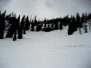
After a surprisingly pleasant descent back to the saddle and lunch in the lee of the ridge, we headed back to camp, skinning back to our previous high point, head-planting off a little cornice, and laying some turns back to the road near Meadows Campground. We were back in camp by about 1:30.
We returned to the car the following morning. There were very large, deep tire tracks in the snow well above the water cut, and whoever it was had moved the offending boulder.
More photos at http://picasaweb.google.com/mlangley7019/2010HartSPass?feat=directlink
The road was blocked at Dead Horse Point (3700') by a large rock too big for the two of us to move. After some debate we decided to park and hike in anyway. After the rock the road was perfectly drivable for another 2 miles until a deep water cut at 4500'. There was significant snow on the road not far beyond that, and we put our skis on at about 3 miles from the car and 5000'. This was significantly shorter than where we drove to in 2009. We camped at Hart's Pass (6200').
Saturday we left camp at a leisurely 9:30 and headed S of the pass on the road and up to a saddle above Meadows Campground where the PCT crosses over from the W to the E side of the ridge. After skinning S to a high point we descended to the saddle below a prominent N ridge from the shoulder of Totie Peak. I ascended the ridge about 2/3 of the way up where I turned around because of strong, gusty winds that were getting worse the higher I went.
After a surprisingly pleasant descent back to the saddle and lunch in the lee of the ridge, we headed back to camp, skinning back to our previous high point, head-planting off a little cornice, and laying some turns back to the road near Meadows Campground.
 We were back in camp by about 1:30.
We returned to the car the following morning. There were very large, deep tire tracks in the snow well above the water cut, and whoever it was had moved the offending boulder.
More photos at http://picasaweb.google.com/mlangley7019/2010HartSPass?feat=directlink
Nice Mark -- glad you guys didn't get too soggy over there.
Hey Mark,
I played with the Picasa photo a bit -- in order to get the right URL to embed the img, you have to right-click on the picture you want and select "Copy Image Location" or "Copy Image URL". Once you have that, just click the Image or Thumbnail button in the posting window and paste the URL wherever it asks for it.
I played with the Picasa photo a bit -- in order to get the right URL to embed the img, you have to right-click on the picture you want and select "Copy Image Location" or "Copy Image URL". Once you have that, just click the Image or Thumbnail button in the posting window and paste the URL wherever it asks for it.
I drove up there on 5/15 and made it to 4600' according to mytracks on droid. There were no rocks impeding our path although a couple 4-inchers that gave the underbelly of the civic hell.
Thanks, Marcus. I'll insert them when I have some time. I just used the URL link it suggested for Emails and IM.
gibbycu - there were regular tire tracks immediately beyond the rock, so I'm pretty sure it was a recent addition to the landscape. Glad it didn't trap us uphill of it! :)
gibbycu - there were regular tire tracks immediately beyond the rock, so I'm pretty sure it was a recent addition to the landscape. Glad it didn't trap us uphill of it! :)
Beautiful trip! I was thinking of heading that way this weekend, but another set of plans is getting cancelled due to weather...
For picasa users: If you go to the picasa page showing the photo you want to embed there's a link on the right side of the page labeled "Link to this Photo". If you click on that, then select size 800pix and check the "image only" box. Then just cut and paste the url from the "Embed Image" box. That's just 5 more steps then google should make you do...
For picasa users: If you go to the picasa page showing the photo you want to embed there's a link on the right side of the page labeled "Link to this Photo". If you click on that, then select size 800pix and check the "image only" box. Then just cut and paste the url from the "Embed Image" box. That's just 5 more steps then google should make you do...
I tried that link the first time, which is what gave me problems. Marcus's technique worked fine and pretty straightforward.
nice work!
Reply to this TR
Please login first: