May 30, 2010, Reynolds Peak
5/30/10
2554
5
Having seen both of our Memorial Day weekend plans dissolved by the rainy forecast, ScottK and I opted for a day tour on Sunday. Hoping to find a pocket of sun, we headed way north and east to do Reynolds Peak outside of Twisp. We didn't find the best snow in the world but did find sun and had an overall good trip.
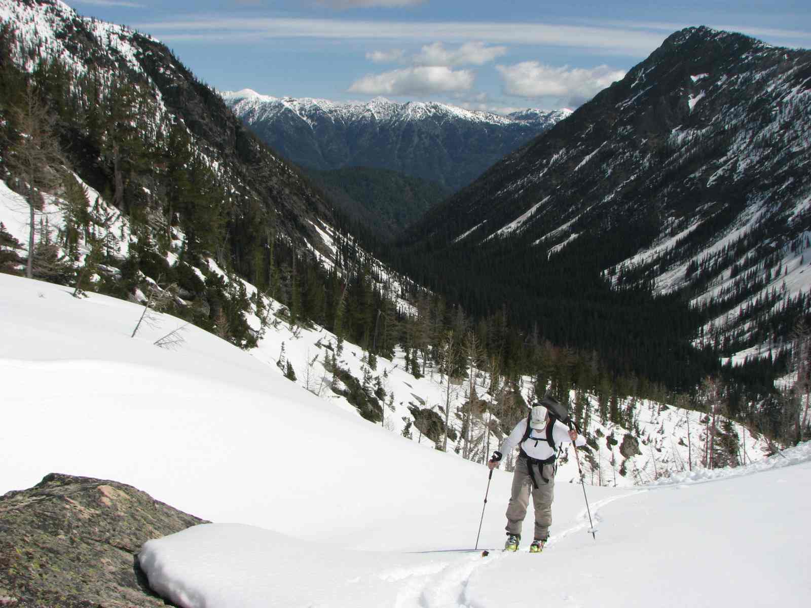
We decided to climb via the South Fork of Reynolds Creek. The road is open to the trailhead and after bedding down there we were on our way before 5:30AM. Patches of snow appear around 4,300 ft with continuous snow starting around 4,500 feet. The route descriptions on SummitPost and prior reports describe hitting an open area roughly 2.5 miles in at 4,650 feet and then moving about 0.3 miles further to 4,700 feet and then turning left to cross the creek and then heading up along the South Fork of Reynolds Creek. Our altimeter watch was off a bit despite being reset at the trailhead and the "open area" was not as open as we thought it would be based on the map, so we ended up crossing a bit higher than intended and had trouble finding the ascent route along the south fork. The crossing wasn't too bad as we found a nice solid snow bridge on top of a big log. After going in circles for a bit, we finally got on route. This involved ascending about 200-300 feet of moderately steep, tree-filled slopes before things leveled out and we were on very gentle terrain leading up to the open basin at 5,500-5,600 feet. The route descriptions recommended being on the left of the creek, but with full snow coverage, we found the going on the right of the creek worked just fine.
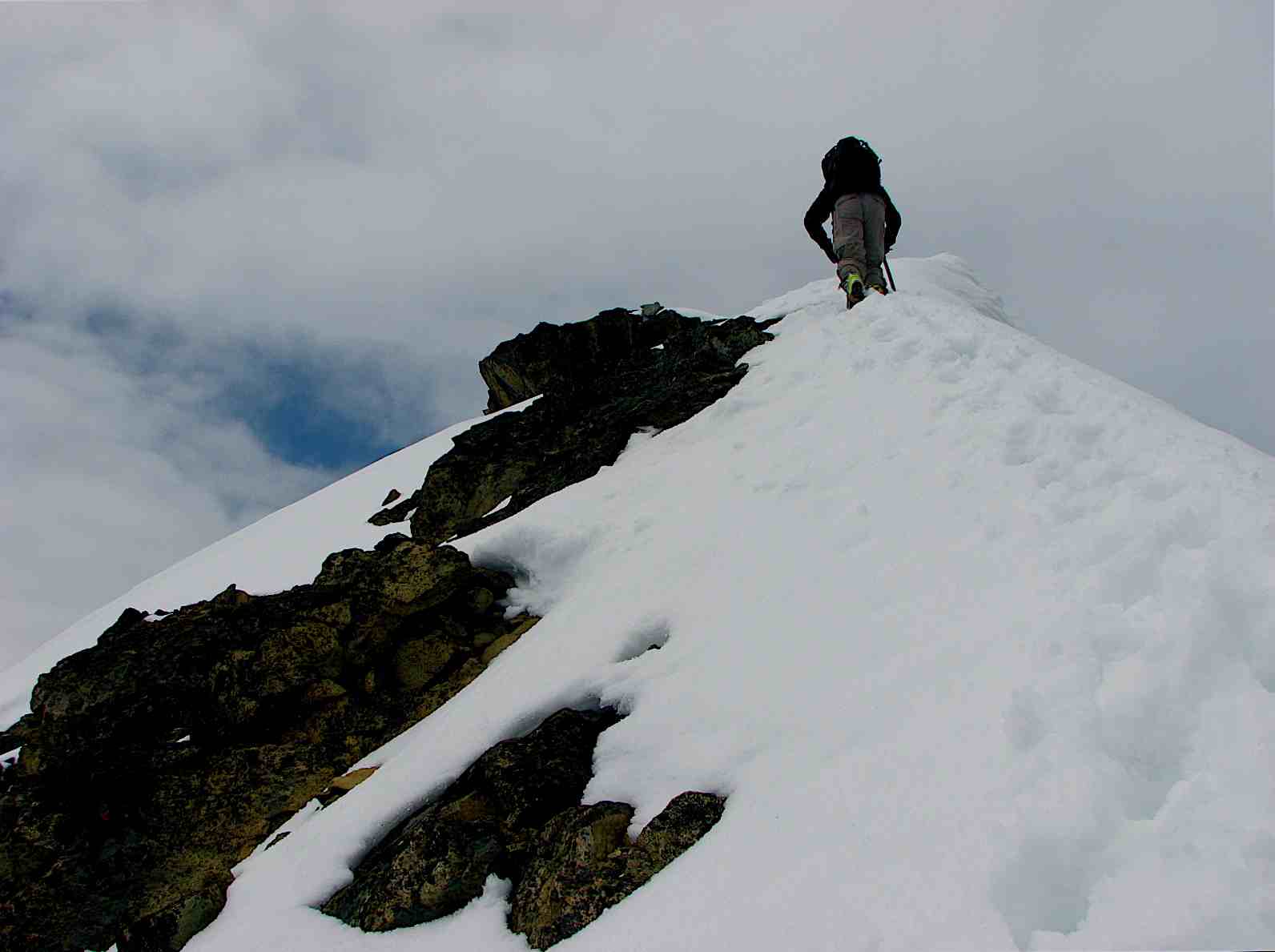
Once in the basin (and in the sun!), there are two potential ascent routes to the upper slopes of the peak: a gully on the right and a ravine to the left of that gulley (there is also a valley that goes way to the left below the ridge that separates this basin from the Williams Lake area). The more direct slopes to the right of the basin were too melted out for a ski ascent. We opted to ascend via the ravine to an upper basin where we then worked our way up onto the south east face of the peak. Skinning was slow in the heavy, mushy new snow. Lots of sloughs off the steeper aspects, but we were able to find a low enough angle route weaving up through the southeast face and worked our way up to below the summit block. From there we followed tracks from some earlier climbers towards the summit. We opted to take a lower angle snow slope to a saddle on the right ridge line of the peak, to the left of a triangular looking rock face. From the top, there was a short section of exposed scrambling before gaining an exposed snow arrete that runs to the summit. This felt very El Dorado-like and definitely got one's attention. A fall to the north would be quite bad. Fortunately, the snow was soft with good purchase for booting and we got up without problem.
After a short stint on the summit with some increasing high clouds, we opted to downclimb the arrete, feeling more stable that way. We then came down a different snow-filled gulley to the left of our ascent route, down-climbing in steps put in by an earlier group of descending climbers. Once down off the summit block, we donned our skis. Anything steep was sloughing very easily so we picked our way down, traversing the steeper aspects and letting the sloughs go and only turning on the less steep portions. The snow was mushy but easy for turning. We got back down to the upper basin without a problem and then picked our way down the gulley to the left (this was the one we saw on the right from the lower basin when we were ascending) to the lower basin. In good conditions, this would be a fun shot but we were picking our spots with all of the soft snow.
From there we came down through the forest staying to the left of the creek. Lots of rolling terrain but skins were not needed and we made good time through the widely spaced trees, only taking our skis off for the last 300 feet down to the creek when things tightened up and the snow was no longer easy to ski. At the bottom, we found our original crossing from the morning and then picked up the trail for the 2.5 miles out to the car. Overall, 12 hours on the trail but that included about an hour moving in circles in the morning with out navigation snafu.
We decided to climb via the South Fork of Reynolds Creek. The road is open to the trailhead and after bedding down there we were on our way before 5:30AM. Patches of snow appear around 4,300 ft with continuous snow starting around 4,500 feet. The route descriptions on SummitPost and prior reports describe hitting an open area roughly 2.5 miles in at 4,650 feet and then moving about 0.3 miles further to 4,700 feet and then turning left to cross the creek and then heading up along the South Fork of Reynolds Creek. Our altimeter watch was off a bit despite being reset at the trailhead and the "open area" was not as open as we thought it would be based on the map, so we ended up crossing a bit higher than intended and had trouble finding the ascent route along the south fork. The crossing wasn't too bad as we found a nice solid snow bridge on top of a big log. After going in circles for a bit, we finally got on route. This involved ascending about 200-300 feet of moderately steep, tree-filled slopes before things leveled out and we were on very gentle terrain leading up to the open basin at 5,500-5,600 feet. The route descriptions recommended being on the left of the creek, but with full snow coverage, we found the going on the right of the creek worked just fine.
Once in the basin (and in the sun!), there are two potential ascent routes to the upper slopes of the peak: a gully on the right and a ravine to the left of that gulley (there is also a valley that goes way to the left below the ridge that separates this basin from the Williams Lake area). The more direct slopes to the right of the basin were too melted out for a ski ascent. We opted to ascend via the ravine to an upper basin where we then worked our way up onto the south east face of the peak. Skinning was slow in the heavy, mushy new snow. Lots of sloughs off the steeper aspects, but we were able to find a low enough angle route weaving up through the southeast face and worked our way up to below the summit block. From there we followed tracks from some earlier climbers towards the summit. We opted to take a lower angle snow slope to a saddle on the right ridge line of the peak, to the left of a triangular looking rock face. From the top, there was a short section of exposed scrambling before gaining an exposed snow arrete that runs to the summit. This felt very El Dorado-like and definitely got one's attention. A fall to the north would be quite bad. Fortunately, the snow was soft with good purchase for booting and we got up without problem.
After a short stint on the summit with some increasing high clouds, we opted to downclimb the arrete, feeling more stable that way. We then came down a different snow-filled gulley to the left of our ascent route, down-climbing in steps put in by an earlier group of descending climbers. Once down off the summit block, we donned our skis. Anything steep was sloughing very easily so we picked our way down, traversing the steeper aspects and letting the sloughs go and only turning on the less steep portions. The snow was mushy but easy for turning. We got back down to the upper basin without a problem and then picked our way down the gulley to the left (this was the one we saw on the right from the lower basin when we were ascending) to the lower basin. In good conditions, this would be a fun shot but we were picking our spots with all of the soft snow.
From there we came down through the forest staying to the left of the creek. Lots of rolling terrain but skins were not needed and we made good time through the widely spaced trees, only taking our skis off for the last 300 feet down to the creek when things tightened up and the snow was no longer easy to ski. At the bottom, we found our original crossing from the morning and then picked up the trail for the 2.5 miles out to the car. Overall, 12 hours on the trail but that included about an hour moving in circles in the morning with out navigation snafu.

Nice work Andy!! 8) Thanks for the details, sounds like some peaks in that area may be worth a trip if this weather remains.
Nice report and photo's Andy.
Nice! We skied from the saddle between the north and south peaks of Reynolds a couple of years ago. Great ski and a beautiful view from up there.
Nice job Scott and Andy, and a good call on heading east of the crest. It was socked in all day along the Nooksack yesterday.
Reynolds has been on my list for a while. Way to go. The ski off the summit looks really fun.
Reply to this TR
Please login first: