April 26, 2010, Silverstar, Silverstar creek
4/26/10
WA Cascades East Slopes North
2008
0
North Cascades highway is a beautiful drive. Sometimes that's hard to remember driving back in the rain. Left Seattle Sunday afternoon, our foursome "bivy'd" at the Rolling Huts. More comfortable than sleeping on the ground and it saved us bringing an extra vehicle for a car bivy. On the snow at 6:35, it wasn't hard to follow the tracks up climbers left of the creek. Maybe a week or two left of skinning from the road.
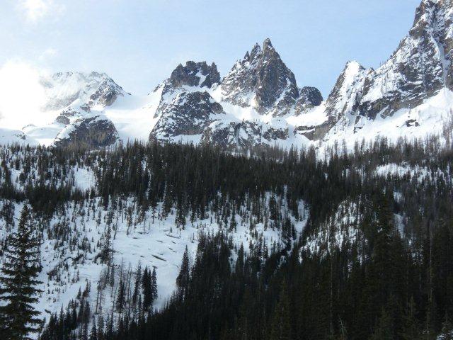
A tad icy through the trees, but still reasonable traction for all but one of our party--interestingly the only one not on Black Diamond skins. Hmmm. Unfortunately, Mark had to call it a day half way up the larches section. Has anyone else had difficulty with g3 skins? 11:00 AM saw us having lunch atop the larches section. We made quick time on the upper mountain, excellent skin track all the way to the top of the col from Sunday's group. Thanks Cat! Took a little over two hours to cover the gain from 6200 feet to the top of the saddle 8600?. Saw evidence of fresh slides from the cliffs above the larches, some big chunks too, indicating slab releases and not just sloughs. On our return, Mark reported seeing a slide come down over our skin track just after we rounded the corner. We didn't even hear it.
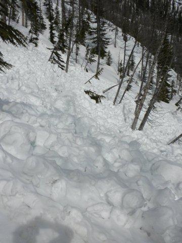
Hazy sun in the morning, darkening to overcast skies as we approached the glacier made for a comfortably cool climb. We saw lots of tracks from the day before, no evidence of fresh snow, and not much evidence of freeze-thaw. Weather moved in as we hit the top, but pretty benign flakes, light wind and haze. We managed to avoid the ensuing whiteout by an hour perhpas. The snow was soft and felt lighter and lighter as we climbed, so we were surprised and a little disappointed by the descent in the upper mountain. Very uneven conditions had all of us taking falls. The worst culprits were avy debris under a smooth layer, and breakable crust also hidden under powder. I had at least 3 double heel releases, with one notable face plant. That's rare for me, since I have what Greg euphemistically calls "a strong sense of self preservation." (Which is his way of calling me a sissy.) Still, not really a complaint, still skiiable. Lost my old ice ixe on one of those tumbles when it got separated from my new ski pack. Guess it wasn't as securely fastened as i thought it was! The conditions improved greatly as we descended and the ski through the larches was a delight. Skiing the creek on the way down was better than a terrain park. Back at the car by 3:45, it had just started to drizzle. Timing is everything.
http://picasaweb.google.com/dangreenfield3/2010_04_26Silverstar02?authkey=Gv1sRgCMaG6OiKtsakMA&feat=directlink
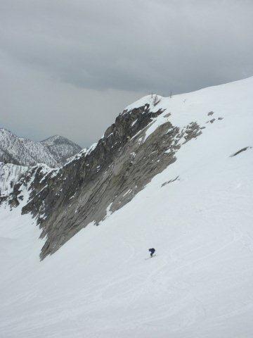
Notes: Route finding was very easy, but stay climber's left of the creek until you have to cross. Bear right for easy climbing once you hit the meadow, and traverse back under the cliffs to make the glacier. All the slopes go, but the one on the left is easiest and clockwise around the big rocks is easier still. Brought rope and glacier gear and left it all in the car once we saw snow at the road. Greg says he has seen crevasses on the glacier. I have not seen anything open up there even as late June. Crampons stayed in the pack, but i could see using them on the upper mountain on an icy morning. Ski crampons useful in the trees. Terrific combination of forest, open mid-alpine (larches section) and high mountain skiing. A gentle north aspect is a nice change of pace too.
A tad icy through the trees, but still reasonable traction for all but one of our party--interestingly the only one not on Black Diamond skins. Hmmm. Unfortunately, Mark had to call it a day half way up the larches section. Has anyone else had difficulty with g3 skins? 11:00 AM saw us having lunch atop the larches section. We made quick time on the upper mountain, excellent skin track all the way to the top of the col from Sunday's group. Thanks Cat! Took a little over two hours to cover the gain from 6200 feet to the top of the saddle 8600?. Saw evidence of fresh slides from the cliffs above the larches, some big chunks too, indicating slab releases and not just sloughs. On our return, Mark reported seeing a slide come down over our skin track just after we rounded the corner. We didn't even hear it.
Hazy sun in the morning, darkening to overcast skies as we approached the glacier made for a comfortably cool climb. We saw lots of tracks from the day before, no evidence of fresh snow, and not much evidence of freeze-thaw. Weather moved in as we hit the top, but pretty benign flakes, light wind and haze. We managed to avoid the ensuing whiteout by an hour perhpas. The snow was soft and felt lighter and lighter as we climbed, so we were surprised and a little disappointed by the descent in the upper mountain. Very uneven conditions had all of us taking falls. The worst culprits were avy debris under a smooth layer, and breakable crust also hidden under powder. I had at least 3 double heel releases, with one notable face plant. That's rare for me, since I have what Greg euphemistically calls "a strong sense of self preservation." (Which is his way of calling me a sissy.) Still, not really a complaint, still skiiable. Lost my old ice ixe on one of those tumbles when it got separated from my new ski pack. Guess it wasn't as securely fastened as i thought it was! The conditions improved greatly as we descended and the ski through the larches was a delight. Skiing the creek on the way down was better than a terrain park. Back at the car by 3:45, it had just started to drizzle. Timing is everything.
http://picasaweb.google.com/dangreenfield3/2010_04_26Silverstar02?authkey=Gv1sRgCMaG6OiKtsakMA&feat=directlink
Notes: Route finding was very easy, but stay climber's left of the creek until you have to cross. Bear right for easy climbing once you hit the meadow, and traverse back under the cliffs to make the glacier. All the slopes go, but the one on the left is easiest and clockwise around the big rocks is easier still. Brought rope and glacier gear and left it all in the car once we saw snow at the road. Greg says he has seen crevasses on the glacier. I have not seen anything open up there even as late June. Crampons stayed in the pack, but i could see using them on the upper mountain on an icy morning. Ski crampons useful in the trees. Terrific combination of forest, open mid-alpine (larches section) and high mountain skiing. A gentle north aspect is a nice change of pace too.
Reply to this TR
Please login first: