Eldorado, 4/18/10
4/15/10
WA Cascades West Slopes North (Mt Baker)
4954
12
No Rest For The Wicked
Synopsis: Scott and I climbed Eldorado.
More Photos: http://www.flickr.com/photos/operativem
Distance: 5 Miles
Vertical: ~7000 feet
Leg 1: 1600 vertical, Cascade Pass Parking Lot to Talus Field.
Leg 2: 2100 vertical, Talus Field to Notch overlooking Roush Creek snowfield
Leg 3: 1500 vertical, Roush Creek snowfield to Inspiration Glacier.
Leg 4: 1300 vertical, Inspiration Glacier to Eldorado Summit
Leg 5: 7000 vertical, The Descent
Terrain Rating: Leg 1, SIMPLE
Terrain Rating: Leg 2, COMPLEX
Terrain Rating: Leg 3, COMPLEX
Terrain Rating: Leg 4, COMPLEX
Comments On Stability: Stability Very Poor BTL, Stability Poor at ATL, Stability Excellent in ALP.
Part 1, Seattle to Milepost 20
Scott and I drove up Interstate 5 beneath dark, unsettled skies filled with plush masses of blue and gray clouds. We drove to Marblemount in the dark, through occasional rain, and beneath invisible mountains, wondering if staying at Washington Pass would have been a better choice for Sunday. Not sure what to make of the weather, we continued to the trailhead where the occasional star served as a glimmer of hope that the weather might improve. But since this is the North Cascades, neither of us were very optimistic.
When we arrived at milepost 20, the last of the light had long since left the sky, but we were greeted with the scent of pine and the sound of whirring creeks. Given the viciousness of approaches in the North Cascades, the scent of pine and the soft sound of flowing water serves as a pleasant enticement that usually ends the moment you take even one step off the road. It's like smelling perfume before the teeth appear.
After a few hours of sleep, we awoke to find the sky bursting with stars. This felt like a gift, since signs of poor weather rarely end with clear skies in maritime mountain ranges. The North Cascades are no exception to this rule, but even these mountains are not immune to continent-sized high-pressure systems.
Part 2, The Vertical Jungle
After arranging our packs and drinking some excellent Starbuck's powdered coffee, we fought off the shivers and set out at ~3:30AM. This trip begins with a typical North Cascades bushwack across the Cascade River, where the dead trees that serve as bridges look more like medieval torture devices than anything resembling safe passage. The slippery logs, studded with splintered branches, and hovering above pools of murky water, seem to whisper a quiet but unmistakable warning. This is not Europe, where cable cars are ready to whisk you into the sky, and it's not Crystal Mountain or Paradise, where, very often, a ski lift, or a skin track, waits just a few minutes from the car.
After crossing the Cascade River in darkness, we scrambled up the beautiful "rain forest" for two hours, climbing steadily along the steep, muddy strip of dirt that passes for a climber's trail. When you can't see, you quickly begin to rely on your other senses. As we climbed the muddy trail, we listened for the endless sound of pouring water, and we knew that we were on the correct route. Our bodies contorted as we changed shape to fit our packs, on which we were carrying skis and ski boots, through, above, around, and below tight spaces and fallen trees.
The most amazing part of visiting such a complete ecosystem is the privilege of observating its daily rituals, which include avalanches, rockfall, and extreme weather. For the smart and experienced, presence in and among these rituals is less likely to result in death.
But smarts and experience don't save everyone.
The Eldorado Range is draped in something close to temperate rainforest, and the mountains are stacked from bottom to top with all the natural processes you would expect to find. Up high, the forces of wind and ice are busy rearranging the mountains to suit their chaotic vision. What water pummels and cuts, gravity drags downhill. The action of avalanches also reshapes the mountain environment, turning old growth trees into matchsticks and piles of mulch. And after the furious destruction, open space remains. These openings provide important foraging grounds and habitat for a variety of animals, including the animals who enjoy skiing.
Eventually, the light of dawn laid the stage for a burlesque strip tease, in which the immense, naked figures of Cascade Pass, Sahale Arm, and the cruel, 2000 metre face of Johannesburg Mountain were slowly revealed. Somewhere on the eastern end of Johannesburg is the astonishing 1000 metre Couloir Johannesburg, which, I have been told, means "go eff yourself" in French. When I think about it, the north face of Johannesburg actually reminds me of Mt. MacDonald, the "gatekeeper" of Rogers Pass, which is perhaps best known for producing avalanches so savage that the Canadian-Pacific railroad company was forced to drill a 9 kilometre tunnel beneath its rocky guts.
After following the climber's trail to its end, Scott and I arrive at the talus field only to find the mossy, appliance-sized rocks partially hidden beneath piles of isothermal snow that also conceal toppled alder thickets, slippery strangles of rotten brush, and ankle breaking moats. Skiable snow is "just" a couple hundred vertical feet above us, but in order to climb higher, we must solve this puzzle of rocks and brush. I don't like talus, and since I weigh 200lbs, talus covered in rotten snow is especially unpleasant. Our wobbly, almost tumbling climb takes place under the watchful eyes of the stone Queens of the Cascade River Valley.
Let me describe the terrain in front of us. The vertical jungle is now below us, and the alpine plateau is somewhere above us. The mountain peaks are above the alpine plateau. Limiting our line of sight into the alpine plateau is a confusing pile of hills and cliffs that sit directly above the vertical jungle and directly below the alpine plateau. These hills are filled with creeks, boulders, enormous swaths of avalanche debris, and the scraggly remainders of what used to be a forest. Here and there, avalanches have used physics, instead of PhotoShop, to edit out the trees. The mangled forest is in a rather sorry state of affairs: some trees are punished with grotesque amputations of their uphill branches, and the proudest trees are summarily executed.
The route always seems simple when you're staring at a map, but the actual terrain is incredibly intricate. You can reach a mountain top by traveling uphill, right? Yes, of course, but traveling uphill isn't always straightforward. The map doesn't show every creek and cliff. The map doesn't show the unstable snow that you must go around, or the piles of avalanche debris that you cannot possibly climb. Traveling a big route in the mountains involves solving hundreds of puzzles, and the nature of these trips can vary by the day or even the hour.
Despite the somewhat circuitous nature of our route through the convoluted terrain below the alpine plateau, we manage to make several smart decisions and quickly reach the alpine.
Part 2, The Boiler Room
After spending hours crawling up through the dark, twisting guts of the vertical jungle and the maze of hills and cliffs that follow, reaching the alpine is a revelation. There are amazing views of the range, including Sahale, Boston, and Torment to the east, and the monstrous sight of Johannesburg to the southeast. And yet the price is simple enough: find your way across the Cascade River and solve the puzzles of the drainage, with total disregard for any torture and toil you may endure.
We climb rapidly through the unobstructed alpine plateau and ascend the ridge quickly, finally reaching the notch that leads to the Roush Creek snowfield. We are rewarded with additional views, but there is another enormous snowfield that we must climb in order to reach the Inspiration Glacier, and we must cross the Inspiration before we can even start climbing the ridge to the summit. So, even after climbing the vertical jungle, and slowly finding our way through the tumbling mess of hills below the alpine plateau, a lot of climbing remains.
But route-finding will be much easier.
After a quick break, we descend the bootpack to the Roush Creek snowfield, losing vertical in the process. It's an easy, non-technical task that places us on an enormous snowfield ~1400 vertical below the Inspiration Glacier. The snowfield itself is a beautiful sight, all the rolls and pillows, everything plastered with snow.
Through blistering sun, and the metaliic scent of sweat, we climb like soldiers. The temperature continues to rise, and we are serenaded by the patter of loose snow avalanches and the clatter of rock fall descending from the cliffs that separate the Roush Creek valley from the Eldorado Creek valley. Once again, the forces of wind and ice and sun are hard at work rearranging the mountains. By now, as we approach 5000 feet of climbing, I'm feeling unusually tired and bonky, so we stop and refuel. This turns out to be a good decision, since, more than many other people, my endurance is limited by sugar and electrolytes, and I drop once my sugar is gone.
Onward we climb, and it's the kind of climbing that delivers a continuous stream of stinging sweat droplets to your eyes, like some unusual torture. It's the kind of climbing that results in open mouthed breathing in an environment so bright that you can sunburn the inside of your mouth. Our efforts put us at the entrance to the Inspiration Glacier, and the summit of Eldorado is finally revealed.
Inspiration Glacier is a peaceful, wandering sheet of ice, and though the glacier is fat from the winter snows, and though its surface is reassuringly smooth, we rope up anyway. Grateful for the gradually descending track, and motivated by the eye-watering views of the summit, we quickly cross the glacier and climb to the notch near the base of the summit pyramid. At the notch we are greeted by a fast, cold wind that will not relent, and we begin the final climb.
Part 3, Eldorado
Despite the metaphors of nakedness, ascending the summit ridge is not a question of making the mountain submit. While the steep, windswept ridge that leads to the summit is broad, there are places during the ascent where a fall would lead to fairly bad consequences. No, instead we will travel carefully and judiciously to the summit at 8868 feet.
Skinning up the bountiful, rolling terrain that leads to the summit is easy, and thanks to the wind, neither of us overheat. We skin across snow that has been blasted, crusted, and refrozen while the wind actively loads the lee slopes with slabby powder. Eventually you climb enough to realise that satisfaction is imminent.
In a strange anti-climax, I stop a just short of the summit, while Scott continues ahead. The intense wind drives turns particles of snow into crystalline daggers, and without a belay, I do not feel comfortable going any further. During the ascent, we carefully monitored snow conditions, and found that a combination of wind and sun has turned the snowpack into a crunchy wooden foam. To avoid making a mistake in difficult snow, I descend about 50 vertical feet and transition. Hesitant, I scrawl rough turns over the mix of crust, dust, and windboard, which makes for very challenging skiing. Scott descends from the summit on his snowboard, and, as usual, he makes it look very easy.
Part 4, Escape
After retracing our steps to the notch, we skiied beautiful, buttery snow down to the Inspiration Glacier and roped up again. Cruising across the glacier, we were soon at the top of the ample Roush Creek snowfield. From there we lost elevation rapidly, and arrived at the base of the notch we descended much earlier in the day. The snow was frozen when we descended in the morning, and as expected, the short, west-facing couloir is now filled with a loathsome mix of foamy, slushy wet grains. Scott, who is much lighter than me, leads the way, and he somehow manages to dig through the sludge to find firm snow below. Such amazing contrasts: one moment you're racing down the snowfield and the next moment you're elbow deep in cold, wet snow, pulling yourself uphill while the sun works on your exposed flesh. Throughout the entire trip, this was the only place where I thought: we don't belong here.
From the top of the notch, our descent was at first relatively pleasant. We managed to intentionally release a few small, wet avalanches, one of which left an impressive scour mark as it slipped down the hill like a drunken tortoise.
Upon reaching treeline, snow conditions worsened, becoming glop and mush so deep that it was barely skiable. Concerned about unsafe conditions, we chose to avoid descending the talus field, and instead descended the Eldorado Creek avalanche path, hoping we could find a safe place to cross the creek. We wandered down the avalanche path, through flagged trees and deep patches of pillowy snow that looked appetizing, but skiied like quicksand. Again, Scott made it look so easy, while I struggled, trying to turn in the funky isothermal slop. On several occasions, I chose the path of least resistance and simply glissaded with my skis in front of me.
Finally, we reached the last of the skiable snow, above a cliff band where there just happened to be a safe spot to cross the creek. We took a short break and marveled at the horrors of the runout zone. I don't know the history of this avalanche path, but I imagine that the trees were chewed up first, allowing subsequent avalanches to remove the undergrowth and dirt until nothing but bare rock remained. The runout zone, which looked more blast zone than the end of an avalanche path, was strewn with sun-bleached fragments of dead trees that looked like bones. Of course, they were bones ... the bones of a long dead forest. It was magnificent and ugly, a quiet place where snowmelt flowed peacefully through the annihilation zone until it crashed into patches of muddy filth on the exposed rocks far below.
After crossing the creek, a fairly simple, descending bushwack lead us back to the bottom of the talus slope, which we scrambled directly across with ease. From there, we found the climbers trail.
Our final transition involved changing from ski boots to hiking shoes. Then we shouldered our heavy packs and walked back down.
Highlights: Just about everything.
Lowlights: Absolutely awful snow below 5000 feet.
Tools: 30m 8mm rope, harness, 2x ice screws, 3x tapes, 3x slings, 2x 2mm slings, locking carabiner, 4x wire gate carabiner, 3x nuts, transceiver, shovel, probe, first aid kit, 2x gloves, soft shell jacket, softshell pants, upper baselayer, lower baselayer, 2x synthetic longsleeve undershirts, 1x synthetic fleece, 1x goggles, 1 sunglasses, 4 litres of water, 10x ClifShot, 3x Starbucks Via Coffee, 3 ClifBars, 1x V8 Splash, 2x V8 regular, skis, skins, boots, poles, hiking shoes.
Map:
[img]http://farm5.static.flickr.com/4060/4535425837_645af3aaa1_o_d.jpg[/img]
Scott, Feeling Inspired By The Glacier
[img]http://farm5.static.flickr.com/4032/4536683134_921551efff_b_d.jpg[/img]
Scott, On The Summit
[img]http://farm5.static.flickr.com/4015/4536065164_e52e80fd92_b_d.jpg[/img]
Cool! Man, either I gotta get my jealousy under control or Scott has to get a job. This is killing me!
Great effort but....7,000 feet is a long way to go to pull up just short of the summit???
Great effort but....7,000 feet is a long way to go to pull up just short of the summit???
Nice write-up of a gnarly trip. Clearly you two are going to need to be separated...
good seeing you guys out there. we ended up traversing pretty high across the talus field on the descent then just bushwhacked down to the trail from there. slow-going but could of been a lot worse.
here are some shots i got of you guys on the way up:
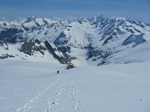
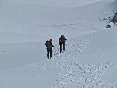
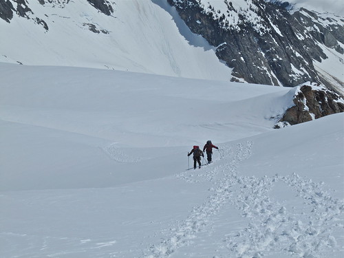
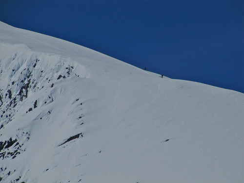
the rest of the pics are here: http://www.flickr.com/photos/bryanestes/sets/72157623769558837/
here are some shots i got of you guys on the way up:
the rest of the pics are here: http://www.flickr.com/photos/bryanestes/sets/72157623769558837/
WOw! Very well written.
Thanks for being a gracious, safe, knowledgeable partner. It was a very good day.
Thanks for being a gracious, safe, knowledgeable partner. It was a very good day.
Eldorado is a great peak, nice trip!
Fwiw, what you refer to as the "Roush Creek Snowfield" is actually glacier higher up. In the right season it is more heavily crevassed than the flat and uncrevassed upper sections of the Inspiration glacier.
Fwiw, what you refer to as the "Roush Creek Snowfield" is actually glacier higher up. In the right season it is more heavily crevassed than the flat and uncrevassed upper sections of the Inspiration glacier.
Great read!
Almost makes me want to go but the approach sounds brutal.
Great work!
Almost makes me want to go but the approach sounds brutal.
Great work!
Great writing.
Thanks.
Thanks.
Thanks for the kind words. I revised this trip report last night, because my initial scribbles made me look like an uneducated moron.
Scott, you're a great touring partner and fantastic rider. Not to mention nimble and very clever. Thanks for following my train of thought, I owe you one or two now. Hopefully we'll get one or two more trips this season. Maybe a big line somewhere exotic... but you have to supply the brain power and I have to get my skis sharpened! And those powdered drink packets taste great, but man, my sinuses are still burning.
Bestes206, thanks for the photos. You guys are machines, and it was a pleasure to watch you cruise right up the mountain. Of course, it was also a little embarrassing... There are several photos of your party on my Flickr site, but you guys were always so far ahead that you look like specks in the pictures. Next time, do you think you could go just a bit slower so I won't feel quite so inadequate ... err, uh, so I can get better photos. ;)
Scotsman, the approach isn't brutal in the Hummelesque sense, but it is a workout. Be sure to bring plenty of treats and travel light. Every PNW skier should experience the succulent pleasures of the Cascade River Road.
Thanks for the conditions report. You don't bring much food along on your trips, do you? All clif bars and shots? Man, I need something that sticks to my gut for big trips
JoshK, Thanks for the clarification. The description "Roush Creek Snowfield" refers to the lower regions.
Juan, I don't eat much on tours, because eating solid food makes me nauseous unless I get a reasonable break for digestion and have a lot of water available. I didn't even touch my ClifBars until we reached the climber's trail and began the hike down.
Juan, I don't eat much on tours, because eating solid food makes me nauseous unless I get a reasonable break for digestion and have a lot of water available. I didn't even touch my ClifBars until we reached the climber's trail and began the hike down.
As usual Scott, you are a vertical animal. Nice work.
Nice report. You really captured the combination of adventure, beauty and sufferfest of a one day on Eldorado. I told myself that I would never do it again....now i'm not so sure anymore.
Reply to this TR
Please login first: