May 12, 2004, Mt Meager (BC), East Ridge
5/12/04
Canada BC
9439
1
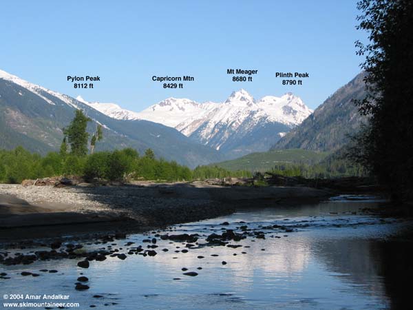
Mount Meager is the northernmost of the Cascade volcanoes, located about 35 miles NW of Whistler as the crow flies. The Meager group actually consists of several overlapping volcanic peaks erupted upon a pedestal of non-volcanic basement rocks of the BC Coast Mountains. The main summits rise over 7000 ft above the broad glacial valley of the Lillooet River, and numerous steep glaciers guard the upper flanks of the peaks. The area is quite remote, over 40 miles from the nearest town of Pemberton including over 25 miles of gravel logging road to reach the Lillooet River Bridge at the confluence of Meager Creek. From there, an abandoned dirt logging road switchbacks up the heavily clearcut East Ridge of Mount Meager from 1400 ft all the way up to nearly 4000 ft. This provides the most direct access to the alpine region and the highest summits in the group, 8680 ft Mount Meager and 8790 ft Plinth Peak. Both peaks have rocky summit pinnacles and are probably not skiable from the true summit, but are skiable from near the summit. I convinced Matt Swallows to join me on this adventure to the northernmost outpost of the Cascades.
This year, a below-normal snowpack in southwestern BC coupled with a warm March and April had melted out the Upper Lillooet River FSR to beyond the bridge (km 37, 1400 ft) by May 1, weeks ahead of normal. Unfortunately, most of the snow on the surrounding hillsides below 3500 ft was also long gone. Even worse, flooding during the record rainfall in October had damaged portions of the Meager Creek FSR, including the bridge to the popular hot springs, and so the BC Forest Service has decided to gate the entire road system closed at the Lillooet Bridge, leaving us many miles of dry logging road to reach snow. We parked at the bridge and started hiking at 10:30am, the very late start resulting from a bad decision to try to drive farther up the Lillooet FSR for a look-see, eventually getting stuck in a snowdrift near km 45 (2000 ft) from which it took nearly an hour to extract my Pathfinder.
After taking the obvious turnoff from the Meager Creek Road (first right in about a mile, the gate appears to be permanently open), the logging road forks numerous times and it took us 3 attempts to find the correct branch (we had GPS, but no roads are shown on the latest topo map, dated 1976). Anyway, don't take the first well-graded left fork, stay straight/right here. At a 3-way junction in about a half-mile at UTM 471000 5607300 (1800 ft), don't take the sharp left either (overgrown and impassible even on foot), but take the middle fork which bears left and uphill. Follow this for about a half-mile and then take a left onto a brushy road at 470800 5607800 (2200 ft), don't take the nicer road straight ahead. The road is high-clearance 4WD to this point due to a couple of deep waterbars, but is in fine shape otherwise. The left fork climbs steeply uphill, beginning a series of 6 or more regular switchbacks up the clearcut to 3700 ft (469600 5608000) and beyond. The brush is thick enough at times to impede walking, but the roadbed is in good shape, even smooth. A chain saw could make short work of all the brush (no stems in the brush are over 1/2 inch thick) and make the road driveable up to 3700 ft or higher. We finally reached solid snow 2-4 ft deep above 3500 ft, so we skinned up and angled steeply left onto the crest of the East Ridge, and then followed the gentle ridge crest to timberline at 5500 ft. The route continues along the East Ridge to over 7000 ft, but the way to the summit involves angling downwards off the right (north) side near 6500 ft and traversing the NE and north flanks onto the unnamed glacier between Meager and Plinth. This glacier leads to the saddle between the two peaks, from which the NW Face of Meager or the SE Face of Plinth can be skied to just below their summits. However, the morning misadventures had cost us any chance of skiing that high, so we decided to call it quits on the ridge around 3:30pm.
Luckily, the day was sunny but cool, with a 6000 ft freezing level, and even in the late afternoon the snow had not turned to mush. We skied down from 5600 ft at 4 pm, with soft corn-like snow on all but the steepest north-facing aspects, which remained firm. The skiing was fine, but the run back down to snowline at 3500 ft was all too brief, and 4+ miles of brushy logging road lay between us and the car parked far below. There are numerous fine skiing and mountaineering objectives in the Meager group, but the gating of the Meager Creek FSR adds 4-10 miles to all of the approaches this spring. It was a nice trip in a remote and scenic location (albeit heavily logged and abused), but the extra effort required right now was not really worth it. Wait till next year, with hopefully a deeper snowpack and ungated road.
Amar Andalkar
click here for an enlarged version of this photo.
Neat trip. How did you get Matt away from the lab? Might I suggest skibiking (see recent Spray Park/Flett Glacier gallery) on the gated roads; it makes the journeys on the road much faster and the downhill is nice.
Matt
Matt
Reply to this TR
Please login first: