Feb 17, 2010, Goat Mtn Avy
2/17/10
WA Cascades West Slopes North (Mt Baker)
6616
7
Took a gander up on Goat Mountain for a mellow day with great views and got a bit shaken. We got lucky in our decision making. We thought it would be colder than it was since my car in Seattle had ice on it this morning, but it was hot up high. The avy danger was moderate but the terrain just felt slidey. So we were very cautious and wove a skin track, threading the needle between wind-loaded but smaller slopes on the left (south) and big avy terrain getting sun-baked on the right (southeast). We were spaced out, covering each other in islands of saftey, and I made very tight switchbacks in the steep trees. Between two patches of trees on a mellow slope near the top, I felt a whoomph underfoot. I didn't see anything move so I figured I was on a flat enough slope. My buddy saw it and called me down to check out the 2 foot crown that cracked 50 yards across and piled up a lot of snow below us. I had triggered that from about 40 feet away. The crack extended beyond the crown and crossed the skin track- a sign that we traveled wisely because it wasn't steep enough to go. The debris hit a major NW facing couloir and ripped that thoroughly. I didn't want to go look down it, but my guess is that it ran the distance since it also had a 2 foot crown across it.
Same thing happened 10 minutes later. 2 foot crown, 30 yards wide, remote trigger. Both due south-facing. I saw another crack, and we decided to ski down quickly. In the exposed terrain we skied faster than hell, then had some beers in a safe spot where we could unwind.
For pictures of the surrounding peaks:
www.skistories.blogspot.com
thanks for the beta great report
Great job with awareness and navigation choices. Anything you'd do differently?
Did you get a look at what it was sliding on?
Did you get a look at what it was sliding on?
I'm really glad we didn't go up the SE ridge which was where we were heading. It just looked slabby and we'd have to cut switchbacks on exposed terrain. It was more of a feeling to reverse our course from that direction.
Then up higher, I'm really glad I stuck to tight switchbacks in the trees. I was tempted to just make them longer and go out on the open slopes. I would have been toast if I did that too. The main clue was the heat. Next time I'd get an alpine start before going onto SE or S slopes. But then, looking at that NW slope rip...I was really hoping nobody was down there. I might wait for corn snow before going back into avy country. That's three times in 2 weeks for me I've seen cracks and have turned around. Time to take a step back.
No we didn't look at the sliding bed surface. As soon as we decided to turn around, it was a race against the sun heating the slopes we had yet to ski. Which was actually really fun!
this scares the whoomphin heck outta me ...
btw .. great pix
btw .. great pix
Interesting TR and beautiful photos in your blog. Glad you avoided the sensitive snow first hand.
I am curious about the conditions setting up your remote triggers and their site(s) on Goat Mt. Here are a few questions/issues that maybe you could comment on:
The avalanche you remotely triggered, is its crown seen on the little knob in the center of your 2nd to last blog picture? Is this located roughly by the red circle on my attached picture?
Did the slide run down the chute which flows NE into the Swamp Creek drainage?
Besides warming by sun, what were the conditions like up there? Your blog photos of Shuksan show major wind transport of snow from roughly the northeast which would load slopes in the aspect you were climbing. Did you see any of that going on during your trip?
The Baker telemetry data before your trip shows some evidence of new snow with strong wind from the south, then the wind reversed to the north and northeast but it was pretty light in velocity.
I know from successive trips in February to the Heliotrope/Grouse Creek area that snowfall during these recent storms have been really variable by elevation (much more snow the higher you go) and that the NE wind is much stronger than is recorded at the Baker telemetry site. This isn’t surprising, as they are different places, but we all use the Baker telemetry to give some indication of conditions in a much broader general area. Also, in places, there was a very solid crust formed on sun affected slopes around 6-7K ft which would make a great bed surface for slabs formed by the winds (east to north) associated with high pressure systems.
Thanks for any comments.
Btw, the picture in your blog labeled “Heliotrope” is of Hadley Peak (right side of photo) which is the high point on Chowder Ridge. Chowder Ridge and Bastile Ridge would likely block your view of Heliotrope at the elevation of Goat Mt.
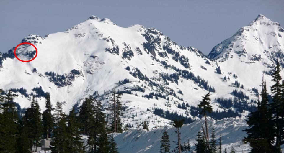
Yep, you hit the nail on the head. That was the spot, and everything you described sounds accurate. Except the couloir that was triggered ran NW towards Tomyhoi, not NE. The wind was blowing hard on the ridges, but quite quiet in the bowls. Watching the winds on Shuksan was impressive. Strong NE. Didn't notice a shift N, we might have come down before that.
I can email you pics of the slide. I don't know how to condense them on this, and I don't like my fam seeing avalanche stuff on the blog.
This email address is being protected from spambots. You need JavaScript enabled to view it.
I can email you pics of the slide. I don't know how to condense them on this, and I don't like my fam seeing avalanche stuff on the blog.
This email address is being protected from spambots. You need JavaScript enabled to view it.
author=cons link=topic=15657.msg65547#msg65547 date=1266717404]
Yep, you hit the nail on the head. That was the spot, and everything you described sounds accurate. Except the couloir that was triggered ran NW towards Tomyhoi, not NE.
I can email you pics of the slide.
My bad, I meant NW, but wrote NE.
Email sent, thanks.
Reply to this TR
Please login first: