Feb 8, 2010, Rainier, Muir, Sun and Graupel-Powder
2/8/10
WA Cascades West Slopes South (Mt Rainier)
6262
1
An absolutely amazing day on the Muir Snowfield. Brilliant sunshine above layers of wispy clouds and fog. Near-calm puffs of wind on the Snowfield fading to basically zero at Camp Muir, only the second time I've ever been there in dead-calm. And most importantly, 4-5" of new snow which had fallen in similarly calm conditions, totally smooth and not wind-affected at all. Not light powder, but graupel-like particles about 1mm in size, yet totally cohesionless and skiing as silky smooth as any blower pow. Outstanding stuff! And quite a surprise to find it, with no real hint of any such thing in the telemetry from the previous 36 hours.
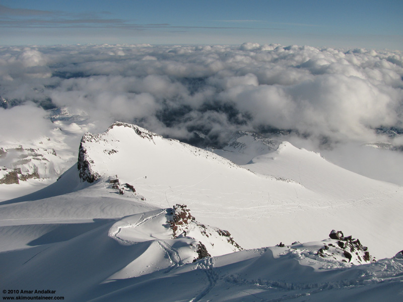
Got a late start from Seattle after checking the webcams in the morning to make sure it was sunny, and finally skinned up from Paradise around 11am. Followed a nice skin track to Camp Muir just after 2pm, and then continued skinning on up Cowlitz Cleaver. There was a snowshoe / posthole track up the Cleaver which I tried to follow in spots, but in several places it was better to just break my own proper skin trail in the graupel-powder, which was 1-2 ft deep on the lee (NE side) of the Cleaver, but barely an inch deep on the rocky crest. A quick half-hour of effort brought me to the flat at 10500 ft, atop the main south facing gully. Tremendous views from here, it's always fun to skin up the ridge and look down on Camp Muir.
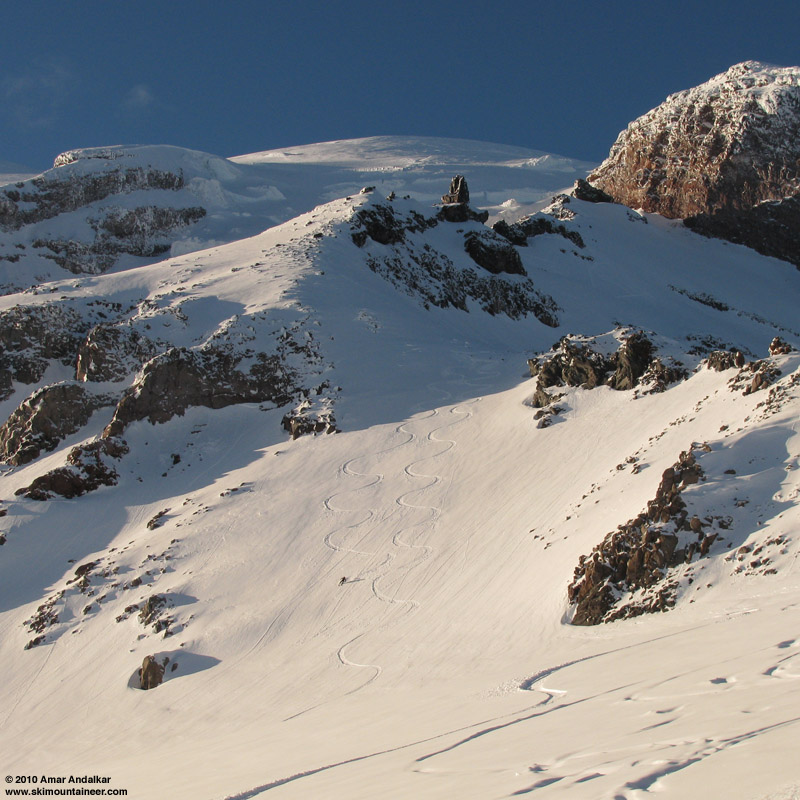
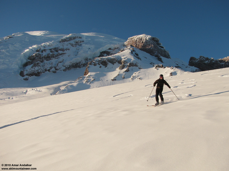
Skied down the gully around 3pm, finding just the slightest hint of an incipient suncrust atop the new snow, but not enough to spoil the sweet turns down the 35-40 degree slope. As the gradient flattened, the almost-crust vanished entirely and the snow became dreamlike in its consistency, a slightly surreal concoction of dense graupel particles which nevertheless skied like power. Super-smooth too, ideal for carving huge GS turns at warp speed. Such a blast!
I noticed someone waving, and veered over to the skin track to find Greg Blaisdell, whom I'd skied with in November and had now been watching my run down the gully. He'd decided to head up there too. The snow was so good, I told him I'd keep going a bit and then skin back up to meet him. So I continued flying down the hill to about 8500 ft, just on the edge of the uppermost cloud/fog layer, and switched back to skins. Made it back up to about 9800 ft, just as Greg came down the gully, carving a second set of tracks paralleling mine.
I quickly switched back to ski mode, and we skied down together the rest of the way, still stunned by how unbelievably great the snow was. Best of all, the fog layer had faded completely and we enjoyed perfect visibility the whole run, as the Mountain slowly turned golden in the last half-hour before sunset. As we neared Pan Face, the sun had begun to affect the snow in spots, with a noticeable suncrust on steeper SE-S-SW aspects. Anything west-facing, like the leftmost edge of Pan Face, was still in fine shape and free of crust, as were east aspects. It was pretty easy to avoid many of the bad spots and stick to the favorable aspects most of the way down, with only a few really crusty areas on the last few hundred feet above the parking lot. Not a damper in any way on the elation experienced above.
A memorable day with about 6400 vert of mostly excellent to amazing turns. I've skied from Camp Muir nearly 80 times since my very first backcountry ski trip up there in June 1996, but the snow conditions this time were among the few best of all those trips. Even better than 12 days earlier (Jan 27, 2010) which had also featured unusually fine conditions for midwinter, consistently good windpacked powder the entire way from Muir to car, with no crust at all but also no truly amazing powder-like snow such as we had this time.
[tt]MOUNT RAINIER RECREATIONAL FORECAST
NATIONAL WEATHER SERVICE SEATTLE WA
421 AM PST MON FEB 8 2010
SYNOPSIS...DEVELOPING HIGH PRESSURE AT THE SURFACE AND ALOFT OVER THE INLAND NORTHWEST WILL GIVE MAINLY DRY CONDITIONS TODAY.
ANOTHER SPLITTING FRONT WILL AFFECT COASTAL AREAS THIS AFTERNOON THROUGH TONIGHT.
THIS FRONT WILL DRIVE SOUTHEAST TOWARD CALIFORNIA AND NOT MAKE IT INTO THE INTERIOR OF WESTERN WASHINGTON.
AFTER ANOTHER DRY PERIOD ON TUESDAY AND TUESDAY NIGHT...STRONGER SYSTEMS WILL AFFECT THE REGION STARTING LATE WEDNESDAY.
A MORE ACTIVE PATTERN WILL CONTINUE INTO NEXT WEEKEND.
MONDAY...CLOUDY EARLY THIS MORNING THEN BECOMING PARTLY SUNNY. FREEZING LEVEL 4000 FEET.
MONDAY NIGHT...MOSTLY CLOUDY. FREEZING LEVEL 4000 FEET.
TUESDAY...PARTLY SUNNY. FREEZING LEVEL 4000 FEET.
TUESDAY NIGHT...MOSTLY CLOUDY. FREEZING LEVEL 4000 FEET.
WEDNESDAY...MOSTLY CLOUDY. FREEZING LEVEL 4000 FEET.
WEDNESDAY NIGHT...CLOUDY WITH A CHANCE OF SNOW AND RAIN. SNOW LEVEL 3000 FEET.
THURSDAY THROUGH SUNDAY...SNOW AND RAIN LIKELY. SNOW LEVEL 3500 FEET.
TEMPERATURE AND WIND FORECASTS FOR SELECTED LOCATIONS.
MON MON TUE TUE WED
NIGHT NIGHT
SUMMIT (14411 FT) 0 -2 1 1 3
W 5 SE 10 SW 5 W 20 W 35
CAMP MUIR(10188 FT) 19 14 18 14 18
SW 5 W 5 W 10 W 15 W 25
PARADISE (5420 FT) 32 29 40 27 34
NE 5 E 5 E 5 CALM S 5
LONGMIRE (2700 FT) 42 32 43 28 40
CALM CALM CALM CALM CALM
[/tt]
Got a late start from Seattle after checking the webcams in the morning to make sure it was sunny, and finally skinned up from Paradise around 11am. Followed a nice skin track to Camp Muir just after 2pm, and then continued skinning on up Cowlitz Cleaver. There was a snowshoe / posthole track up the Cleaver which I tried to follow in spots, but in several places it was better to just break my own proper skin trail in the graupel-powder, which was 1-2 ft deep on the lee (NE side) of the Cleaver, but barely an inch deep on the rocky crest. A quick half-hour of effort brought me to the flat at 10500 ft, atop the main south facing gully. Tremendous views from here, it's always fun to skin up the ridge and look down on Camp Muir.
Skied down the gully around 3pm, finding just the slightest hint of an incipient suncrust atop the new snow, but not enough to spoil the sweet turns down the 35-40 degree slope. As the gradient flattened, the almost-crust vanished entirely and the snow became dreamlike in its consistency, a slightly surreal concoction of dense graupel particles which nevertheless skied like power. Super-smooth too, ideal for carving huge GS turns at warp speed. Such a blast!
I noticed someone waving, and veered over to the skin track to find Greg Blaisdell, whom I'd skied with in November and had now been watching my run down the gully. He'd decided to head up there too. The snow was so good, I told him I'd keep going a bit and then skin back up to meet him. So I continued flying down the hill to about 8500 ft, just on the edge of the uppermost cloud/fog layer, and switched back to skins. Made it back up to about 9800 ft, just as Greg came down the gully, carving a second set of tracks paralleling mine.
I quickly switched back to ski mode, and we skied down together the rest of the way, still stunned by how unbelievably great the snow was. Best of all, the fog layer had faded completely and we enjoyed perfect visibility the whole run, as the Mountain slowly turned golden in the last half-hour before sunset. As we neared Pan Face, the sun had begun to affect the snow in spots, with a noticeable suncrust on steeper SE-S-SW aspects. Anything west-facing, like the leftmost edge of Pan Face, was still in fine shape and free of crust, as were east aspects. It was pretty easy to avoid many of the bad spots and stick to the favorable aspects most of the way down, with only a few really crusty areas on the last few hundred feet above the parking lot. Not a damper in any way on the elation experienced above.
A memorable day with about 6400 vert of mostly excellent to amazing turns. I've skied from Camp Muir nearly 80 times since my very first backcountry ski trip up there in June 1996, but the snow conditions this time were among the few best of all those trips. Even better than 12 days earlier (Jan 27, 2010) which had also featured unusually fine conditions for midwinter, consistently good windpacked powder the entire way from Muir to car, with no crust at all but also no truly amazing powder-like snow such as we had this time.
[tt]MOUNT RAINIER RECREATIONAL FORECAST
NATIONAL WEATHER SERVICE SEATTLE WA
421 AM PST MON FEB 8 2010
SYNOPSIS...DEVELOPING HIGH PRESSURE AT THE SURFACE AND ALOFT OVER THE INLAND NORTHWEST WILL GIVE MAINLY DRY CONDITIONS TODAY.
ANOTHER SPLITTING FRONT WILL AFFECT COASTAL AREAS THIS AFTERNOON THROUGH TONIGHT.
THIS FRONT WILL DRIVE SOUTHEAST TOWARD CALIFORNIA AND NOT MAKE IT INTO THE INTERIOR OF WESTERN WASHINGTON.
AFTER ANOTHER DRY PERIOD ON TUESDAY AND TUESDAY NIGHT...STRONGER SYSTEMS WILL AFFECT THE REGION STARTING LATE WEDNESDAY.
A MORE ACTIVE PATTERN WILL CONTINUE INTO NEXT WEEKEND.
MONDAY...CLOUDY EARLY THIS MORNING THEN BECOMING PARTLY SUNNY. FREEZING LEVEL 4000 FEET.
MONDAY NIGHT...MOSTLY CLOUDY. FREEZING LEVEL 4000 FEET.
TUESDAY...PARTLY SUNNY. FREEZING LEVEL 4000 FEET.
TUESDAY NIGHT...MOSTLY CLOUDY. FREEZING LEVEL 4000 FEET.
WEDNESDAY...MOSTLY CLOUDY. FREEZING LEVEL 4000 FEET.
WEDNESDAY NIGHT...CLOUDY WITH A CHANCE OF SNOW AND RAIN. SNOW LEVEL 3000 FEET.
THURSDAY THROUGH SUNDAY...SNOW AND RAIN LIKELY. SNOW LEVEL 3500 FEET.
TEMPERATURE AND WIND FORECASTS FOR SELECTED LOCATIONS.
MON MON TUE TUE WED
NIGHT NIGHT
SUMMIT (14411 FT) 0 -2 1 1 3
W 5 SE 10 SW 5 W 20 W 35
CAMP MUIR(10188 FT) 19 14 18 14 18
SW 5 W 5 W 10 W 15 W 25
PARADISE (5420 FT) 32 29 40 27 34
NE 5 E 5 E 5 CALM S 5
LONGMIRE (2700 FT) 42 32 43 28 40
CALM CALM CALM CALM CALM
[/tt]