Sholes Glacier August 1, 2009
8/15/09
3543
7
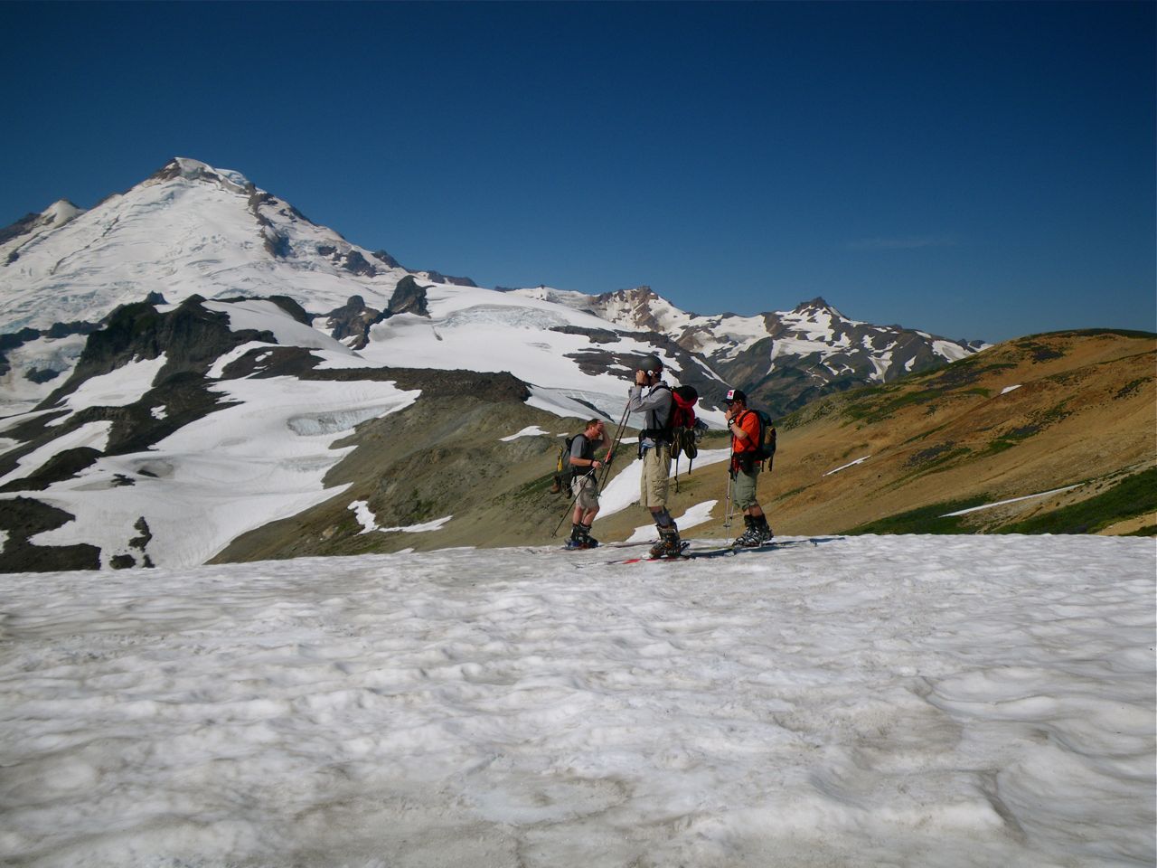
We assembled at the relaxed hour of 7:30 at the Artist Point parking lot. Telemon Bob had camped with Gabe and Tom, while Lee and I drove up the morning of.
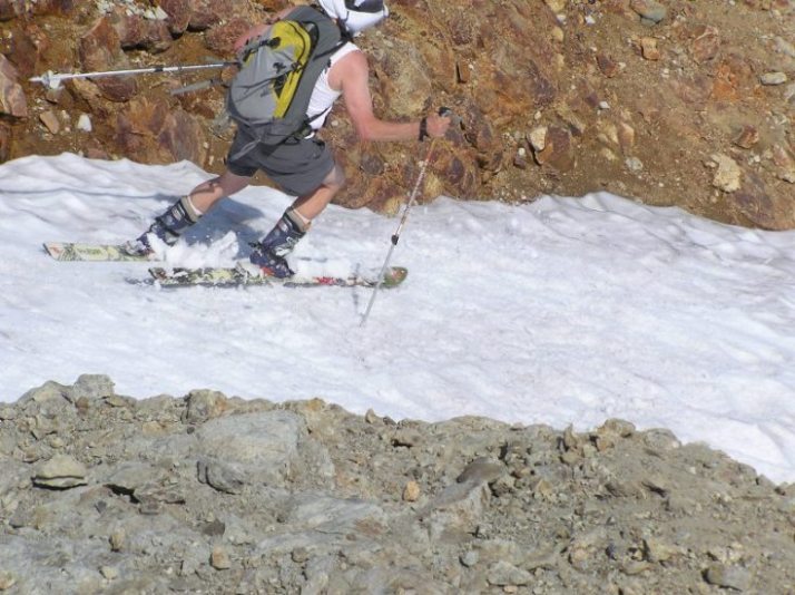
It was a long walk because, guess what, it is pretty dry out there. At about an hour's walk I pointed to the spot where we had started skiing in the middle of the prior August. A while later we checked out the patch that had run 400' last September 30th, and now is cut into two patches. The first respectable run, of about 750', comes down the SE side of Coleman Pinnacle itself.
Lee and I were ahead of the pack and, not knowing about the summer trail around to the left, we climbed up to the lookout point just SW of Coleman Pinnacle, where we gazed down upon the pitiful remnants of what the USGS shows as a much larger glacier, the contrast made more striking this year by the fact that there was nothing but glacier present, the long snow tongues that had yielded good runs last summer are gone.
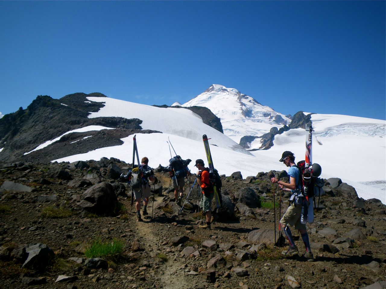
From the top of the point we spotted Bob and Tom below, then Gabe arrived at the top so Lee, Gabe, and I skied down the glacier and cut left onto what Bob said was the September 05 patch, the only snow he had found that month to keep his streak alive. More hoofing and we ended up in time for lunch at the top, or at least one top, of the Sholes. There are several disconnected pinnacles which I guess comprise "The Portals" of which we went to the top of the first, and there are two more beyond.
The top of the Sholes was nice, the summer sun had melted out the sun cups so we could carve them with relative ease. Then the passage to the bottom of the Sholes was not so easy, the first chute looked very crevassed and broken, the second had a moat across part of it, was steep, and probably was skiable, but we traversed hard skiers right and found a mellow way down to the bottom, a total run of about 850' from the top.
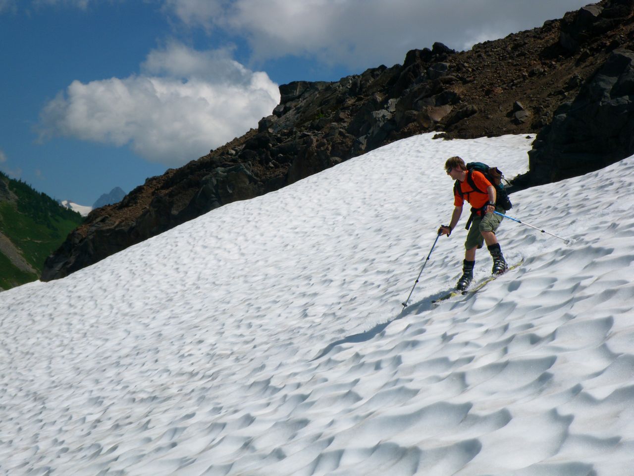
On the way out we went to the top of the Coleman Pinnacle run and made the most of it. On Bob and Tom's advice from prior trips, we dropped packs at the trail half way down and then continued down the nice steep chute that was the most fun run of the day.
Tom and I milked a somewhat pitiful pair of patches on the near side of the trail hairpin to get somewhat closer to home and to get closer to 2500 vf on a long hiking day. The hoof hoof hoof on out to the usual amused comments and questions.
Lee posted a link to some of his pictures on the partners thread, here it is. Bob and Gabe took lots of pictures and hopefully will post a link.
http://www.facebook.com/album.php?aid=94965&id=583488359&l=f3bcd8b48a
Great seeing Bob, Tom, and Gabe again, and good to meet you Lee and welcome to TAY.
It was a long walk because, guess what, it is pretty dry out there. At about an hour's walk I pointed to the spot where we had started skiing in the middle of the prior August. A while later we checked out the patch that had run 400' last September 30th, and now is cut into two patches. The first respectable run, of about 750', comes down the SE side of Coleman Pinnacle itself.
Lee and I were ahead of the pack and, not knowing about the summer trail around to the left, we climbed up to the lookout point just SW of Coleman Pinnacle, where we gazed down upon the pitiful remnants of what the USGS shows as a much larger glacier, the contrast made more striking this year by the fact that there was nothing but glacier present, the long snow tongues that had yielded good runs last summer are gone.
From the top of the point we spotted Bob and Tom below, then Gabe arrived at the top so Lee, Gabe, and I skied down the glacier and cut left onto what Bob said was the September 05 patch, the only snow he had found that month to keep his streak alive. More hoofing and we ended up in time for lunch at the top, or at least one top, of the Sholes. There are several disconnected pinnacles which I guess comprise "The Portals" of which we went to the top of the first, and there are two more beyond.
The top of the Sholes was nice, the summer sun had melted out the sun cups so we could carve them with relative ease. Then the passage to the bottom of the Sholes was not so easy, the first chute looked very crevassed and broken, the second had a moat across part of it, was steep, and probably was skiable, but we traversed hard skiers right and found a mellow way down to the bottom, a total run of about 850' from the top.
On the way out we went to the top of the Coleman Pinnacle run and made the most of it. On Bob and Tom's advice from prior trips, we dropped packs at the trail half way down and then continued down the nice steep chute that was the most fun run of the day.
Tom and I milked a somewhat pitiful pair of patches on the near side of the trail hairpin to get somewhat closer to home and to get closer to 2500 vf on a long hiking day. The hoof hoof hoof on out to the usual amused comments and questions.
Lee posted a link to some of his pictures on the partners thread, here it is. Bob and Gabe took lots of pictures and hopefully will post a link.
http://www.facebook.com/album.php?aid=94965&id=583488359&l=f3bcd8b48a
Great seeing Bob, Tom, and Gabe again, and good to meet you Lee and welcome to TAY.
Travertine has covered the Saturday portion of the trip very well. My son,Gabe, and my buddy, Tom K.(who is known by several members of the TAY community) arrived at the Artist Point parking lot late Friday afternoon (last day of July). Tom has decided to make his first "turns all year" year in celebration of entering his 7th decade, so we hiked up to the east end of Table Mountain and played on the snow until Tom hit 1,000 vf.
Through out the next day I couldn't help thinking how much less snow there was compared to last August and September. For example,The "goat's throat" run off the east side of Camp Kiser which we ran last September was not skiable now. So get out there soon before its all gone. Here are a few of the hundreds of photos shot. http://www.new.facebook.com/album.php?page=1&aid=98233&id=671676794
Through out the next day I couldn't help thinking how much less snow there was compared to last August and September. For example,The "goat's throat" run off the east side of Camp Kiser which we ran last September was not skiable now. So get out there soon before its all gone. Here are a few of the hundreds of photos shot. http://www.new.facebook.com/album.php?page=1&aid=98233&id=671676794
I also wondered what was left after our shock/horror heatwave last week. After bailing on the Sholes idea after turning the corner above Camp Kiser we explored the unnamed lake south of camp on Sunday. Skied several chutes and snowpatches north of Point 5726 and west of Point 5847 adding up to about 1,700 feet. A very pleasant day out, but you have to wonder about September! Looks like I missed you guys by one day.
Wow, that's some narrow snow finger skiing! Probably has a creek under it, too.
Looks like you guys had a blast out there!! After what I was forced to endure on Saturday morning and afternoon, I would have given anything to be out there with you guys!! I hope there will be something good left on Sunday. I am thinking about a pilgrimage out there then.
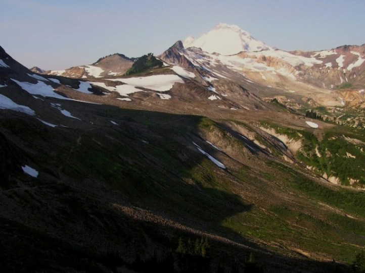
We headed over to Ptarmigan Ridge and the Sholes Glacier on Monday (BC day)... Great hike, and some decent skiing (about four laps totalling 500vm) from the summit of the First Portal down to a small tarn on the summit's NE side. The runs on the Sholes Glacier from the col between the first and second Portal, as well as snowfields dropping South (towards Rainbow Creek) from the same col also looked pretty good, but we ran out of time to ski them... Lots of glacial ice already exposed... it wasn't possible to ski down from First Portal to the lower Sholes Glacier, looked pretty sketchy to ski down to the lower Sholes Glacier from Second Portal, and the lower part of the Sholes Glacier was all ice.
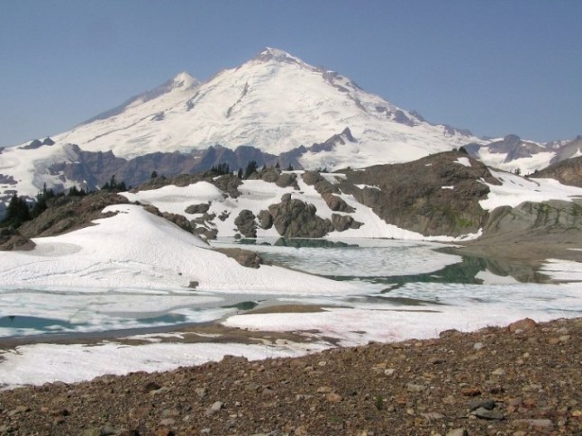
First Portal (left), Sholes Glacier and Second Portal (right). We skied just left out of view of the picture:

View back to Mt. Baker with lots of flowers:

Great day out, and first August turns!!! TAY here we come!!!!
Just hope there'll be some snow left in September...
First Portal (left), Sholes Glacier and Second Portal (right). We skied just left out of view of the picture:
View back to Mt. Baker with lots of flowers:
Great day out, and first August turns!!! TAY here we come!!!!
Just hope there'll be some snow left in September...
I have posted a more complete photographic trip report here: http://www.telemarktalk.com/phpBB/viewtopic.php?t=59417&postdays=0&postorder=asc&start=0
Enjoy,
Bob
Enjoy,
Bob
Wow,
I am not sure that I have ever seen so little snow below Coleman Pinnacle. Certainly not this early. I have never seen so much of the small glacier exposed below the pinnacle as can be seen in the distant shot posted.
Alan
I am not sure that I have ever seen so little snow below Coleman Pinnacle. Certainly not this early. I have never seen so much of the small glacier exposed below the pinnacle as can be seen in the distant shot posted.
Alan
Reply to this TR
Please login first: