July 11 Mt Washington Circumference
7/15/09
OR elsewhere
2997
4
At this point I have been to Oregon 4 times this season scouting and riding different Volcanos from McLoughlin down south to Mt Hood up North. As the season slowly progressed I created a personal goal to ride all of the significant Volcanos in the Cascade Range starting at Mt Lassen in California and Ending at Mt Baker on the Canadian border and hitting all the prominent volcanos along the way. With 30 dollars in my bank account and the touring season nearing its end I wondered how would I find my way back down to Oregon a final time to tackle my last remaining objectives? It started with a email from Buell who was more then willing to give me a few days of work digging trenches for his business in exchange for some much needed funds. So before I knew it I was on my way to Eugene. Fortunately 30 dollars was enough to cover my drive down and Buell was kind enough to provide shelter and food for the next two days. After two exhausting days of digging trenches under the blazing sun I was back on the road with a pocket full of cash and a desire to finish some unresolved business.
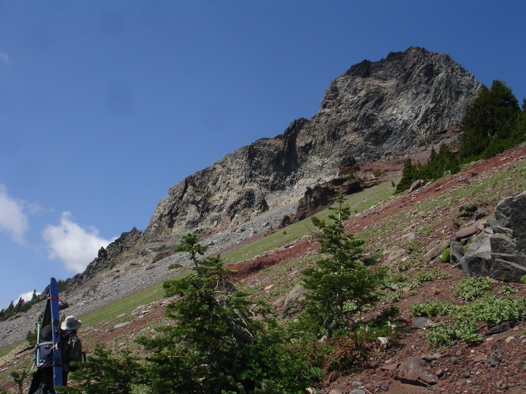
Mt Washington is located in central Oregon off Santiam Pass with the nearest ski resort being Hoodoo. Glaciers have eroded the once massive peak leaving behind rotten rock and clay in its path and a summit pinnacle infamous for horrible rock climbing conditions. Buell and I arrived at Santaim pass around 6 p.m. on Friday night and attempted to scope out different spots to access the trail which would cut down on our trail time. After running into a few dead ends we noticed we could cut off a mile of trail hiking if we could start off in the parking lot for a religious group called the 6th day Adventists but once arriving we were greeted by a security guard in the parking lot. Immediately we got a creepy vibe from the guard who demanded to know what we wanted and why we were there so we left fearing what was going on behind the gate. We decided to do the standard approach from the pacific crest trail and were greeted by massive swarms of mosquitoes and the chilling echoes of the Religious group chanting more then a mile away to the setting sun. I quickly set up camp on the forest floor while Buell feared the mosquitoes and I feared my life.
I woke up to the peaceful sound of a dirt biker offroading at 6:00a.m. and without thinking started my now daily ritual of boiling water for oatmeal and the great motivator known as coffee. The mosquitoes caused us to pack our gear in a fast pace and get onto the trail within 30 minutes of being awoken. We kept a steady pace hiking with swarms of mosquitoes over our heads knowing all to well that if we stopped there would be a feast and we would be the main course. After 3 miles we found a cairn that represented the trail head for the Mt Washington climbing route and started heading east to obtain the Northern ridge which would deliver the most continuous snow and a easily graded ramp to the summit pinnacle. While we went by numerous areas that provided consistent snow we opted to stay on the melted out ridge for fast pasted hiking and scenic views of the Central Oregon Landscape.
Buell Looking at Mt Washingtons SW face
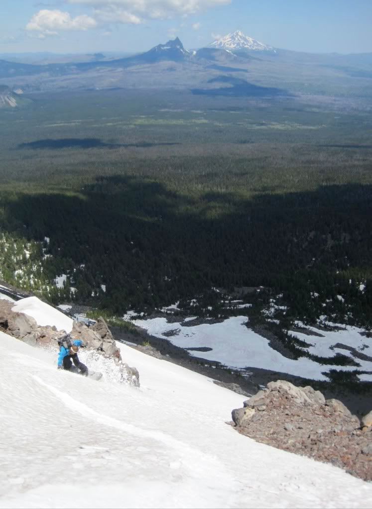
Within two hours we found ourselves at the base of the summit Pinnacle with around 500 feet of loose rock between us and the summit proper. We counted as much as 7 people climbing and I found myself with a major dilemma Should I climb to the summit or start snowboarding. It was a hard decision but I decided that it wasnt a good idea to climb the 4th class exposed rock solo with no rope, harness, protection and other climbers above me so we turned away and went back down to our gear. The North bowl of Washington had the longest fall line on the mountain with well over a thousand vert and no patch carries. We expected the slopes to be suncupped but were relived to see that the snow was smooth and had softened enough to produce some great corn conditions. After ripping down the north face we wondered what to do as the day was still early and Buells reasoning for being on Washington was both to keep me company and check out potential lines for next season.
Ripping down the North face with 3 finger Jack and Jefferson in the background (photo by Buell)
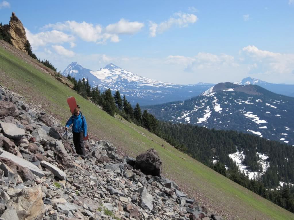
We decided that we would traverse out to a col that separated the North and Eastern bowls and see what other options were available along the way. Once arriving at the col we noticed the snowpack was still strong on Eastern slopes so with no hesitation we rode into the valley decided once again to hike up to a col that separated the Eastern and Southeastern faces. Once on the col we found ourselves having to make a decision we were at the halfway point so either we could back track to the climbing trail or we could finish off a circumference of the mountain. We decided that a circumference traversing the mountain would be more exciting but opted to stay high as there wasnt much snow on the SE face and snow was all together non existent on the SW face. As soon as we reached the SW face we found ourselves traversing through steep scree fields being extra cautious at the possibility of rock sliding down up higher. At one point in the traverse a huge rock started sliding in my direction and I found myself jumping onto the rock then back off of it as it blasted down the slope picking up speed along the way happy that I was still in one peace.
The Never ending Traverse with the Middle, and North Sisters and Belknap Crater in the distance (photo by Buell)
Soon enough we were on the ridge that accessed the NW bowl and were happy to find sufficient snowpack to make another 1000 vert decent into the valley. Earlier in the morning we spotted the line we were standing on top of but decided it was too far of a distance and now ironically we were preparing to ride it. The sun had left its mark on the snow softening it up substantially leaving us with a consistency which yielded some powder like conditions. After ripping down the steeper semi open chute then some lower angled trees we ran out of snow and were forced to hike through sideways trees before reaching lower meadows. By now we were running low on both calories and water so we hastily jumped back onto the PCT for the final excruciating three miles before arriving at our cars. Once at are cars I bid Buell farewell and gave him many thanks for his generosity and within five minutes I was off towards my next objective.
In conclusion Mt Washingtons prime season is mid winter delivering unlimited options from alpine to treed slopes with an average of 1500 feet of perfect fall line. That is if youre willing to deal with the over 6 mile approach.
Same TR with more photos
Mt Washington is located in central Oregon off Santiam Pass with the nearest ski resort being Hoodoo. Glaciers have eroded the once massive peak leaving behind rotten rock and clay in its path and a summit pinnacle infamous for horrible rock climbing conditions. Buell and I arrived at Santaim pass around 6 p.m. on Friday night and attempted to scope out different spots to access the trail which would cut down on our trail time. After running into a few dead ends we noticed we could cut off a mile of trail hiking if we could start off in the parking lot for a religious group called the 6th day Adventists but once arriving we were greeted by a security guard in the parking lot. Immediately we got a creepy vibe from the guard who demanded to know what we wanted and why we were there so we left fearing what was going on behind the gate. We decided to do the standard approach from the pacific crest trail and were greeted by massive swarms of mosquitoes and the chilling echoes of the Religious group chanting more then a mile away to the setting sun. I quickly set up camp on the forest floor while Buell feared the mosquitoes and I feared my life.
I woke up to the peaceful sound of a dirt biker offroading at 6:00a.m. and without thinking started my now daily ritual of boiling water for oatmeal and the great motivator known as coffee. The mosquitoes caused us to pack our gear in a fast pace and get onto the trail within 30 minutes of being awoken. We kept a steady pace hiking with swarms of mosquitoes over our heads knowing all to well that if we stopped there would be a feast and we would be the main course. After 3 miles we found a cairn that represented the trail head for the Mt Washington climbing route and started heading east to obtain the Northern ridge which would deliver the most continuous snow and a easily graded ramp to the summit pinnacle. While we went by numerous areas that provided consistent snow we opted to stay on the melted out ridge for fast pasted hiking and scenic views of the Central Oregon Landscape.
Buell Looking at Mt Washingtons SW face
Within two hours we found ourselves at the base of the summit Pinnacle with around 500 feet of loose rock between us and the summit proper. We counted as much as 7 people climbing and I found myself with a major dilemma Should I climb to the summit or start snowboarding. It was a hard decision but I decided that it wasnt a good idea to climb the 4th class exposed rock solo with no rope, harness, protection and other climbers above me so we turned away and went back down to our gear. The North bowl of Washington had the longest fall line on the mountain with well over a thousand vert and no patch carries. We expected the slopes to be suncupped but were relived to see that the snow was smooth and had softened enough to produce some great corn conditions. After ripping down the north face we wondered what to do as the day was still early and Buells reasoning for being on Washington was both to keep me company and check out potential lines for next season.
Ripping down the North face with 3 finger Jack and Jefferson in the background (photo by Buell)
We decided that we would traverse out to a col that separated the North and Eastern bowls and see what other options were available along the way. Once arriving at the col we noticed the snowpack was still strong on Eastern slopes so with no hesitation we rode into the valley decided once again to hike up to a col that separated the Eastern and Southeastern faces. Once on the col we found ourselves having to make a decision we were at the halfway point so either we could back track to the climbing trail or we could finish off a circumference of the mountain. We decided that a circumference traversing the mountain would be more exciting but opted to stay high as there wasnt much snow on the SE face and snow was all together non existent on the SW face. As soon as we reached the SW face we found ourselves traversing through steep scree fields being extra cautious at the possibility of rock sliding down up higher. At one point in the traverse a huge rock started sliding in my direction and I found myself jumping onto the rock then back off of it as it blasted down the slope picking up speed along the way happy that I was still in one peace.
The Never ending Traverse with the Middle, and North Sisters and Belknap Crater in the distance (photo by Buell)
Soon enough we were on the ridge that accessed the NW bowl and were happy to find sufficient snowpack to make another 1000 vert decent into the valley. Earlier in the morning we spotted the line we were standing on top of but decided it was too far of a distance and now ironically we were preparing to ride it. The sun had left its mark on the snow softening it up substantially leaving us with a consistency which yielded some powder like conditions. After ripping down the steeper semi open chute then some lower angled trees we ran out of snow and were forced to hike through sideways trees before reaching lower meadows. By now we were running low on both calories and water so we hastily jumped back onto the PCT for the final excruciating three miles before arriving at our cars. Once at are cars I bid Buell farewell and gave him many thanks for his generosity and within five minutes I was off towards my next objective.
In conclusion Mt Washingtons prime season is mid winter delivering unlimited options from alpine to treed slopes with an average of 1500 feet of perfect fall line. That is if youre willing to deal with the over 6 mile approach.
Same TR with more photos
Nice report, Kyle...hey, I've got trenches to dig, too... ;D
A six mile approach is nothing for a guy who is willing to dig trenches for two days ...that's earning your turns! Good on ya.
A six mile approach is nothing for a guy who is willing to dig trenches for two days ...that's earning your turns! Good on ya.
Way to go again Kyle--you are tough as nails what with all those holly rollers and 'skiters. Glad you got some good riding in...thanks for the pics as now I don't have to make the recon. drive...
heheh... hard booter needs somebody else to dig his trenches??
author=Rusty Knees link=topic=13829.msg57788#msg57788 date=1247712126]
A six mile approach is nothing for a guy who is willing to dig trenches for two days ...that's earning your turns! Good on ya.
The work wore him out a lot more than any mountain has I think! ;D Fortunately, you can't slow the guy down!
author=ale_capone link=topic=13829.msg57796#msg57796 date=1247759534]
heheh... hard booter needs somebody else to dig his trenches??
Ahhh, winter time groomers on a carve deck! Summer time irrigation trenches are a whole different world!
Reply to this TR
Please login first: