July 1-2, 2009, Mt Rainier, 3 Summits via Emmons
7/1/09
WA Cascades West Slopes South (Mt Rainier)
12351
4
Summary: Skied Mount Rainier via the Emmons-Winthrop route, with full ski ascents and descents of all three 14000 ft summits (Columbia Crest 14410 ft, Point Success 14158 ft, and Liberty Cap 14112 ft), making a beautiful tour of the summit region. Surprisingly, the entire route was easily skinnable with ski crampons from Camp Schurman to the summit, with only a short section that was steep, icy, and sketchy for skinning near 14000 ft. The Emmons-Winthrop route is in great shape crevasse-wise, with only a single dicey crossing at the top of the Corridor near 12000 ft (approx) and no bergschrund issues whatsoever in the usual trouble spots above 13K (the route now traverses far right to the 13600 ft Liberty Saddle). The snow conditions on the Emmons-Winthrop are good but not great, with areas of windpacked powder up high and minimal sastrugi, but the snow surface is becoming very bumpy below 12K, with a proper single-file bootpack only above that and a chaotic cattle-stampede path over 100 ft wide below that, destroying much of the skiable area on the Corridor. Also, ski conditions on the Inter Glacier have deteriorated greatly during the past week, with a very rough, bumpy, dirty surface in nearly all areas, and studded with innumerable rocks of various sizes especially on the lower half and the runout to Glacier Basin. Probably no longer worth the hike in just to ski the Inter, unless also doing the Emmons.
(Click on any image for a larger version.)
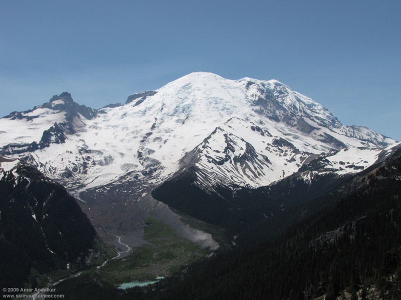
View of the Emmons and Inter Glaciers from Emmons Vista near Sunrise, taken a week ago on 26 June 2009.
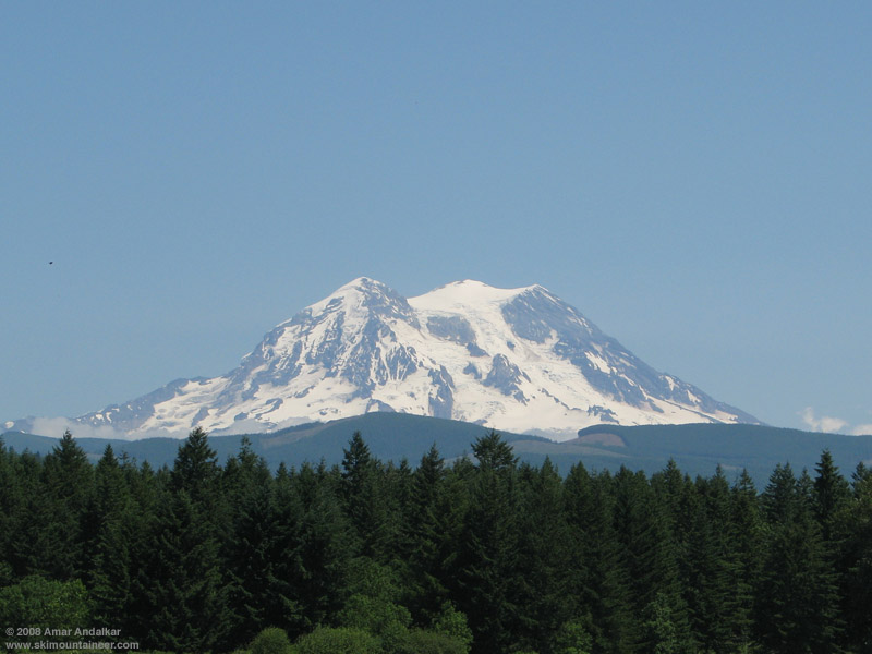
Western view of the three summits of Mount Rainier (Liberty Cap, Columbia Crest, and Point Success left to right), taken a year ago on 07 July 2008 from the viewpoint on SR 161.
Details: Got an unintentionally late start from Seattle, hit some bad traffic, and then it took forever to register at White River, even with only one climber ahead of me (who wasn't even starting until the next day). Heard from the ranger on duty that a climber had fallen into a crevasse on the Emmons route and been heli-evaced, but he had no details (and did not mention that the "climber" was actually a climbing ranger on skis!). So I finally left White River at 4:45pm, much later than planned, hiked 3 miles to Glacier Basin, and skinned from 5950 ft just after the camp, reaching Camp Schurman around 9:15pm just after sunset. The crossing from the Inter to Emmons Glaciers near 9000 ft is a nasty sidehill traverse on loose dirt and mud, easily the most dangerous part of the entire route for me. It turns out that there's a nice moderate snow gully just below this providing all-snow access to the Emmons (which I saw the next day from above), but for some reason no one is going that way, even though the crevasses on the Emmons seem no worse on that variation than the currently in-use route.

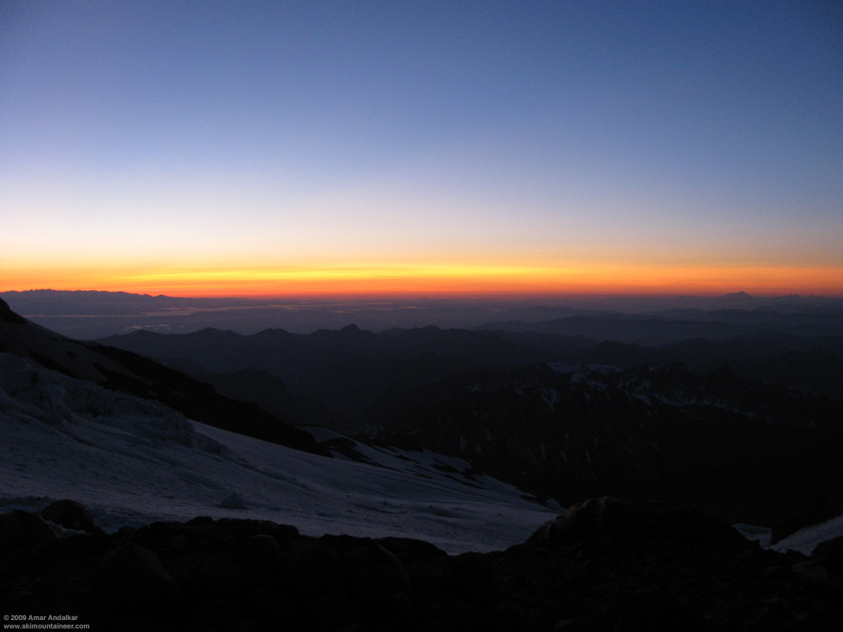
Sunset over Puget Sound from Camp Schurman, with the Olympic Mountains at left and Mount Baker at right on the horizon.
Watched an amazing twilight display of yellows and reds in the sky above Puget Sound while melting a few liters of water on the Jetboil at Schurman before hitting the (bivy) sack. Climbing parties were leaving occasionally from 11pm onward into the wee hours, the only stirrings in an otherwise gloriously calm night. No scurrying rodents this time either. Planned to wake at 5am the next morning, but slept in till 5:35 and missed out on the best colors of alpenglow and sunrise on the Emmons. The only other ski party was heading uphill just after 6am, one skier (Aaron) and one splitboarder (Bart), both skinning with ski crampons. In four previous skis of the Emmons-Winthrop route since 1999, I'd never skinned above Schurman, always cramponing with skis on pack even though I prefer to skin as much as possible. But watching their easy progress on the softening snow of the beautifully sunny and calm morning convinced me to give skinning a shot.

Looking up at the Emmons Glacier about 20 minutes after sunrise.
Headed up at 7am, grip was excellent by sticking to smoother areas of snow on either side of the stampede path, and I realized I was making very steady and efficient progress. Caught up with the other two near the top of the Corridor around 9am and skinned into the now-single and smooth bootpack for a sketchy sidehill traverse on a solid snowbridge above a gaping crevasse, requiring 10 ft of downhill side-stepping which would have been scary without the ski crampons. I scouted just above and found a MUCH better route only 20 ft uphill, and guided the others to it, where they skinned across a 1-2 ft gap with minimal difficulty. This was clearly the way to go on the ski descent too, with a clean ski line requiring only a short hop.

The one sketchy crevasse crossing near 12000 ft (approx) on the Emmons Glacier, seen from just below and looking down from just above.
Skinned up the generally smooth and nice bootpack above this point, the snow in it was mostly softer and grippier than off to either side. Eventually above 12500 ft the route traverses endlessly rightward to reach the 13600 ft Liberty Saddle north of the summit, so having a shallow smooth trench made skinning this much easier than sidehilling the whole way. Spent a while chatting with a group of climbers at the saddle, then continued up the last bit. I realized that since it was only 11am, I'd have plenty of time to kill before skiing back down the Emmons, since the ideal time was probably 2pm or later on this day. So might as well skin and ski all three summits!
The steepest and iciest portion of the entire route this time was above the saddle, near 14000 ft below the rim of the west crater, and much caution and concentration was needed to gingerly switchback and sidestep up the worst 100 ft without falling. Planting a Whippet pick to support some weight helped in a couple of spots. Above, the route flattens into the west crater and then up the NW flank of 14410 ft Columbia Crest. I topped out at 11:45am, realizing with surprise that I had done the whole route from Schurman in a single push without removing skis or pack or sitting down (some of my regular partners who complain about how often I stop would be shocked!). Really nice up there, temps near freezing but feeling much warmer in the sun, winds nearly calm with an occasional soft breath of a few mph. One party had even set up their tent atop the Crest.

Arriving at Columbia Crest after a complete ski ascent.
Spent a long time chatting with a few folks at the summit, and finally skied down through the west crater towards Point Success at 12:30pm. The southerly slopes from the crater down to the 14020 ft saddle were corning up nicely for skiing, and the very gentle ascent from the saddle to 14158 ft Point Success was easily done on skis alone without stopping to put on skins. Enjoyed the view from Point Success for a while, my only prior ascent had been in harrowing conditions in May 2008, high winds and whiteout and survival in a steam cave. Much nicer this time. Skied back down to the saddle and took a long lunch break, melting some very clean and nice snow into 1.5 L of water on the Jetboil.
Then on with skins and ski crampons for the ascent back up to Columbia Crest, now well-softened in the afternoon sun, topping out once more at 2pm and then skiing off the NW side and down to Liberty Saddle. Snow conditions on this part were the worst of the day, a choppy mix of firm windpack and a few icy sections, but most parts had managed to soften somewhat on this warm day. Then skins and ski crampons once more for the easy cruise up to 14112 ft Liberty Cap, with a few incipient crevasses along the ridge but none causing concern on skis. A light westerly breeze had picked up over the previous hour, increasing to 15-20 mph, enough to need a jacket. The south-facing upper slopes of Liberty Cap were nicely corned as I summited just after 3pm, my first time atop this exceptional viewpoint looking down on the huge ice cliffs looming above Willis Wall, the Carbon Glacier far below, and the entire Puget Sound region in the distance. Liberty Cap is the second-highest peak in WA by most fair and objective standards, as it has roughly 500 ft of prominence above the saddle connecting it to Columbia Crest (the two peaks are just over one mile apart), far exceeding the typical cutoff of 300 ft used for compiling lists of peaks and especially 14ers. Point Success has less than 150 ft of prominence, so it misses such a cut.
I hung out on top for a while, enjoying the warm sunshine and stupendous views, then finally clicked in for the descent around 3:30pm. A few nice turns on the southerly slopes, then a long scenic schuss along the ridge crest and easily across Liberty Saddle onto the Winthrop Glacier. The slopes were totally empty by now, I had the entire run to myself. A long sidehilling cruise along and near the bootpack, with only an occasional turn or two on the edgeable windpack, brought me to the first nice set of turns on softened corn below 12800 ft. The tricky crevasse near 12000 ft was easily skied with a short hop, catching a meager 2-3 ft of air, and then hitting nice corn on the Corridor. Sweet turns along the edges of the Corridor for the next 1500 vert, staying away from the ridiculously-wide stampede path in the middle, then following ski tracks which cut left onto a smooth open slope just west of the Corridor. These were the best turns of the day, a wide-open cruise on very smooth corn, not over-softened or mushy at all even as 4pm neared. Cautious turns staying close to previous ski tracks brought me through the dangerous lurking crevasse zone near Emmons Flats, then carving through the bumpy brown snow on the final slope above Camp Schurman, back safely just after 4pm.

Sweet corn skiing on the Emmons Glacier.
Lay down and enjoyed the warm sunshine for a while, much breezier now than in the morning, then packed up and skied out at 5pm. The exit from camp is getting trickier on skis, several large cracks are opening right from its edge, but are still safely negotiable. Had a long chat on the lower Emmons with Jonathan Shefftz, Jeff Huber, Silas, and Eric, heading in for a ski the next day. Thought about going out via the all-snow route onto the Inter Glacier, but chose to follow the bootpack and endure the nasty sidehill mud traverse again. Definitely should have chosen the snow, it would have required a bit more uphill to rejoin the track, but also provided a few more turns on the Emmons.

Zoomed view from 12000 ft looking down at the Emmons-Inter Glacier crossing, showing the current bootpack and the MUCH better all-snow route just downhill.
The skiing on the Inter Glacier was mediocre at best, dirty and bumpy, with only a few semi-smooth areas on the upper half. But even at nearly 6pm, it was well-consolidated and not mush, softened enough to carve through most of the bumpiness. I avoided hitting any of the thousands of rocks which studded the slopes, and skied out to the edge of Glacier Basin, where the trail practically meets the snow. This portion of the Inter Fork creek is still solidly bridged with a thick deposit of winter avalanche debris, snow is probably 10-20 ft thick with no holes or open water until below 6000 ft, where the creek rapidly opens up. Saw lots more skiers down here and all along the trail back to White River, looked like the Friday holiday would see 20-30 skiers and boarders on the route in contrast to Thursday's trio.
A really amazing trip, one of my all-time favorite on Rainier, so nice to enjoy perfect weather on the often windy and stormy Mountain. My 16th summit and 12th ski descent from the top, including 5 descents in 2009 by 5 different routes. It was also my 5th time skiing the Emmons-Winthrop route, all in July (previously in '99, '04, '06, '07), it's too bad I can't seem to hit the route earlier in May or June. But I'm glad that I patiently waited for the first 14000 ft freezing level of the year, thus finding ideal conditions for a complete ski ascent and a scenic tour of the three summits of Mount Rainier. About 11500 ft of total gain for 9500 vert of ski descent, including an extra 1000 vert during the three summits tour, in just over 27 hours car-to-car.

Aerial view from the WSW of the summit region of Mount Rainier including the twin craters and all three summits, taken last year on 12 Apr 2008 from a commercial flight from SeaTac to Tucson.
[hr][tt]MOUNT RAINIER RECREATIONAL FORECAST
NATIONAL WEATHER SERVICE SEATTLE WA
318 AM PDT WED JUL 1 2009
SYNOPSIS...SUNNY AND WARMER WEATHER WILL CONTINUE INTO THE 4TH OF JULY WEEKEND. TEMPERATURES WILL BECOME WELL ABOVE NORMAL. AN UPPER LEVEL TROUGH WILL DEVELOP OFFSHORE ON SUNDAY...KNOCKING TEMPERATURES BACK DOWN TO NORMAL...WITH COOLER CONDITIONS INTO EARLY NEXT WEEK.
WEDNESDAY...SUNNY. FREEZING LEVEL 12500 FEET.
WEDNESDAY NIGHT THROUGH FRIDAY...CLEAR. FREEZING LEVEL NEAR 14000 FEET.
FRIDAY NIGHT AND INDEPENDENCE DAY...MOSTLY CLEAR. FREEZING LEVEL 13000 FEET.
SATURDAY NIGHT...PARTLY CLOUDY. FREEZING LEVEL 12500 FEET.
SUNDAY...PARTLY SUNNY WITH A CHANCE OF SHOWERS. SNOW LEVEL 10500 FEET.
SUNDAY NIGHT...MOSTLY CLOUDY WITH A CHANCE OF SHOWERS. SNOW LEVEL 10500 FEET.
MONDAY THROUGH TUESDAY...MOSTLY CLOUDY WITH A CHANCE OF SHOWERS. SNOW LEVEL 8500 FEET.
TEMPERATURE AND WIND FORECASTS FOR SELECTED LOCATIONS.
WED WED THU THU FRI
NIGHT NIGHT
SUMMIT (14411 FT) 24 23 23 24 25
W 16 W 16 W 23 W 22 SW 23
CAMP MUIR(10188 FT) 44 42 43 44 44
E 6 SW 5 SW 8 SW 12 SW 11
PARADISE (5420 FT) 68 52 74 55 75
E 8 NE 11 SE 8 NE 6 S 9
LONGMIRE (2700 FT) 77 45 81 50 86
CALM CALM CALM CALM CALM
[/tt]
(Click on any image for a larger version.)

View of the Emmons and Inter Glaciers from Emmons Vista near Sunrise, taken a week ago on 26 June 2009.
Western view of the three summits of Mount Rainier (Liberty Cap, Columbia Crest, and Point Success left to right), taken a year ago on 07 July 2008 from the viewpoint on SR 161.
Details: Got an unintentionally late start from Seattle, hit some bad traffic, and then it took forever to register at White River, even with only one climber ahead of me (who wasn't even starting until the next day). Heard from the ranger on duty that a climber had fallen into a crevasse on the Emmons route and been heli-evaced, but he had no details (and did not mention that the "climber" was actually a climbing ranger on skis!). So I finally left White River at 4:45pm, much later than planned, hiked 3 miles to Glacier Basin, and skinned from 5950 ft just after the camp, reaching Camp Schurman around 9:15pm just after sunset. The crossing from the Inter to Emmons Glaciers near 9000 ft is a nasty sidehill traverse on loose dirt and mud, easily the most dangerous part of the entire route for me. It turns out that there's a nice moderate snow gully just below this providing all-snow access to the Emmons (which I saw the next day from above), but for some reason no one is going that way, even though the crevasses on the Emmons seem no worse on that variation than the currently in-use route.
Sunset over Puget Sound from Camp Schurman, with the Olympic Mountains at left and Mount Baker at right on the horizon.
Watched an amazing twilight display of yellows and reds in the sky above Puget Sound while melting a few liters of water on the Jetboil at Schurman before hitting the (bivy) sack. Climbing parties were leaving occasionally from 11pm onward into the wee hours, the only stirrings in an otherwise gloriously calm night. No scurrying rodents this time either. Planned to wake at 5am the next morning, but slept in till 5:35 and missed out on the best colors of alpenglow and sunrise on the Emmons. The only other ski party was heading uphill just after 6am, one skier (Aaron) and one splitboarder (Bart), both skinning with ski crampons. In four previous skis of the Emmons-Winthrop route since 1999, I'd never skinned above Schurman, always cramponing with skis on pack even though I prefer to skin as much as possible. But watching their easy progress on the softening snow of the beautifully sunny and calm morning convinced me to give skinning a shot.
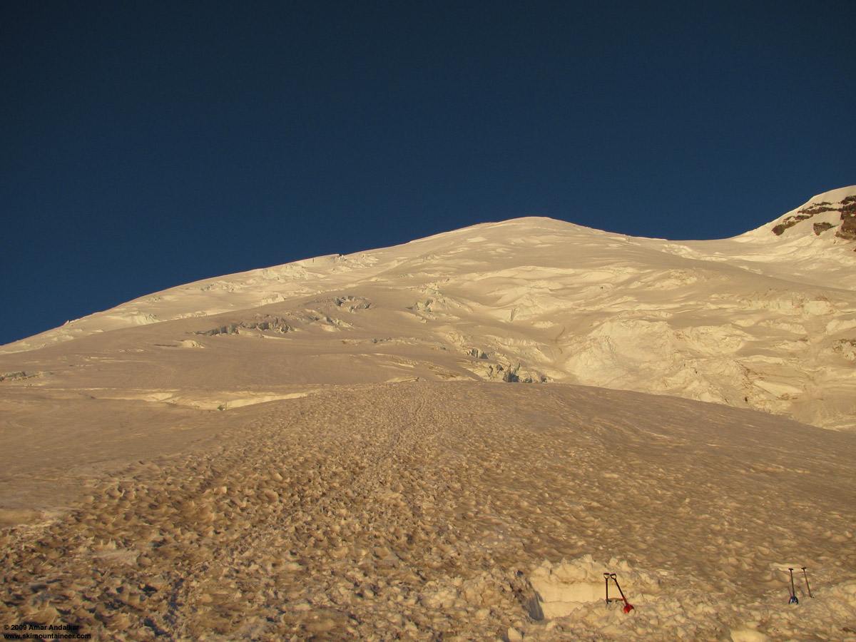
Looking up at the Emmons Glacier about 20 minutes after sunrise.
Headed up at 7am, grip was excellent by sticking to smoother areas of snow on either side of the stampede path, and I realized I was making very steady and efficient progress. Caught up with the other two near the top of the Corridor around 9am and skinned into the now-single and smooth bootpack for a sketchy sidehill traverse on a solid snowbridge above a gaping crevasse, requiring 10 ft of downhill side-stepping which would have been scary without the ski crampons. I scouted just above and found a MUCH better route only 20 ft uphill, and guided the others to it, where they skinned across a 1-2 ft gap with minimal difficulty. This was clearly the way to go on the ski descent too, with a clean ski line requiring only a short hop.
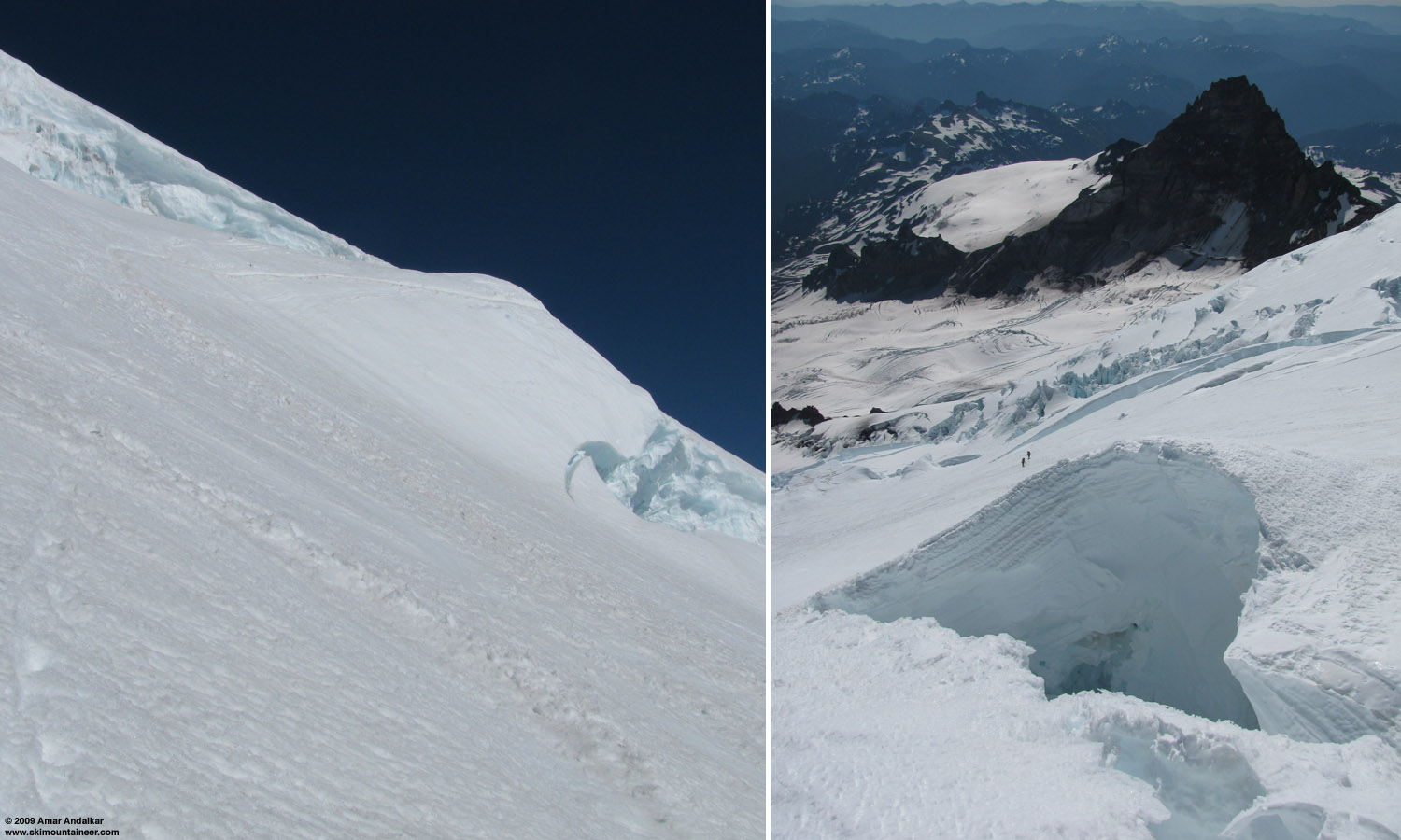
The one sketchy crevasse crossing near 12000 ft (approx) on the Emmons Glacier, seen from just below and looking down from just above.
Skinned up the generally smooth and nice bootpack above this point, the snow in it was mostly softer and grippier than off to either side. Eventually above 12500 ft the route traverses endlessly rightward to reach the 13600 ft Liberty Saddle north of the summit, so having a shallow smooth trench made skinning this much easier than sidehilling the whole way. Spent a while chatting with a group of climbers at the saddle, then continued up the last bit. I realized that since it was only 11am, I'd have plenty of time to kill before skiing back down the Emmons, since the ideal time was probably 2pm or later on this day. So might as well skin and ski all three summits!
The steepest and iciest portion of the entire route this time was above the saddle, near 14000 ft below the rim of the west crater, and much caution and concentration was needed to gingerly switchback and sidestep up the worst 100 ft without falling. Planting a Whippet pick to support some weight helped in a couple of spots. Above, the route flattens into the west crater and then up the NW flank of 14410 ft Columbia Crest. I topped out at 11:45am, realizing with surprise that I had done the whole route from Schurman in a single push without removing skis or pack or sitting down (some of my regular partners who complain about how often I stop would be shocked!). Really nice up there, temps near freezing but feeling much warmer in the sun, winds nearly calm with an occasional soft breath of a few mph. One party had even set up their tent atop the Crest.
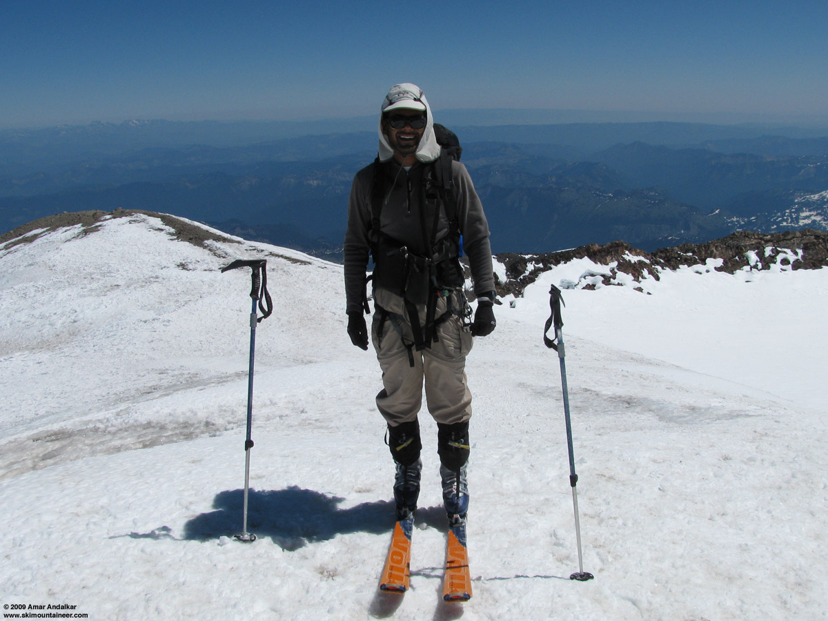
Arriving at Columbia Crest after a complete ski ascent.
Spent a long time chatting with a few folks at the summit, and finally skied down through the west crater towards Point Success at 12:30pm. The southerly slopes from the crater down to the 14020 ft saddle were corning up nicely for skiing, and the very gentle ascent from the saddle to 14158 ft Point Success was easily done on skis alone without stopping to put on skins. Enjoyed the view from Point Success for a while, my only prior ascent had been in harrowing conditions in May 2008, high winds and whiteout and survival in a steam cave. Much nicer this time. Skied back down to the saddle and took a long lunch break, melting some very clean and nice snow into 1.5 L of water on the Jetboil.
Then on with skins and ski crampons for the ascent back up to Columbia Crest, now well-softened in the afternoon sun, topping out once more at 2pm and then skiing off the NW side and down to Liberty Saddle. Snow conditions on this part were the worst of the day, a choppy mix of firm windpack and a few icy sections, but most parts had managed to soften somewhat on this warm day. Then skins and ski crampons once more for the easy cruise up to 14112 ft Liberty Cap, with a few incipient crevasses along the ridge but none causing concern on skis. A light westerly breeze had picked up over the previous hour, increasing to 15-20 mph, enough to need a jacket. The south-facing upper slopes of Liberty Cap were nicely corned as I summited just after 3pm, my first time atop this exceptional viewpoint looking down on the huge ice cliffs looming above Willis Wall, the Carbon Glacier far below, and the entire Puget Sound region in the distance. Liberty Cap is the second-highest peak in WA by most fair and objective standards, as it has roughly 500 ft of prominence above the saddle connecting it to Columbia Crest (the two peaks are just over one mile apart), far exceeding the typical cutoff of 300 ft used for compiling lists of peaks and especially 14ers. Point Success has less than 150 ft of prominence, so it misses such a cut.
I hung out on top for a while, enjoying the warm sunshine and stupendous views, then finally clicked in for the descent around 3:30pm. A few nice turns on the southerly slopes, then a long scenic schuss along the ridge crest and easily across Liberty Saddle onto the Winthrop Glacier. The slopes were totally empty by now, I had the entire run to myself. A long sidehilling cruise along and near the bootpack, with only an occasional turn or two on the edgeable windpack, brought me to the first nice set of turns on softened corn below 12800 ft. The tricky crevasse near 12000 ft was easily skied with a short hop, catching a meager 2-3 ft of air, and then hitting nice corn on the Corridor. Sweet turns along the edges of the Corridor for the next 1500 vert, staying away from the ridiculously-wide stampede path in the middle, then following ski tracks which cut left onto a smooth open slope just west of the Corridor. These were the best turns of the day, a wide-open cruise on very smooth corn, not over-softened or mushy at all even as 4pm neared. Cautious turns staying close to previous ski tracks brought me through the dangerous lurking crevasse zone near Emmons Flats, then carving through the bumpy brown snow on the final slope above Camp Schurman, back safely just after 4pm.
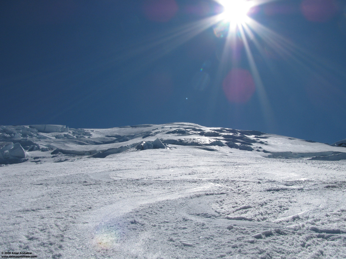
Sweet corn skiing on the Emmons Glacier.
Lay down and enjoyed the warm sunshine for a while, much breezier now than in the morning, then packed up and skied out at 5pm. The exit from camp is getting trickier on skis, several large cracks are opening right from its edge, but are still safely negotiable. Had a long chat on the lower Emmons with Jonathan Shefftz, Jeff Huber, Silas, and Eric, heading in for a ski the next day. Thought about going out via the all-snow route onto the Inter Glacier, but chose to follow the bootpack and endure the nasty sidehill mud traverse again. Definitely should have chosen the snow, it would have required a bit more uphill to rejoin the track, but also provided a few more turns on the Emmons.
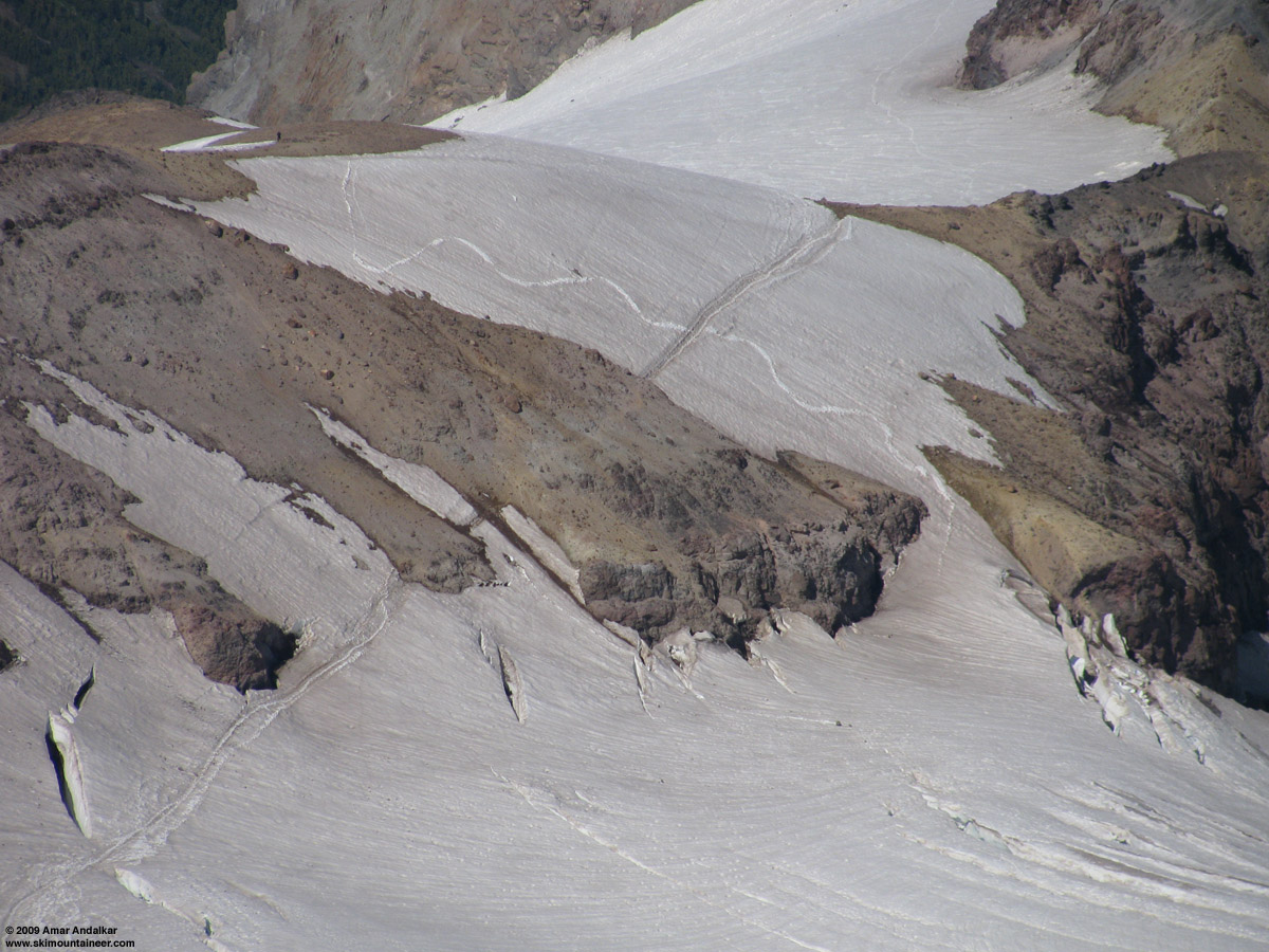
Zoomed view from 12000 ft looking down at the Emmons-Inter Glacier crossing, showing the current bootpack and the MUCH better all-snow route just downhill.
The skiing on the Inter Glacier was mediocre at best, dirty and bumpy, with only a few semi-smooth areas on the upper half. But even at nearly 6pm, it was well-consolidated and not mush, softened enough to carve through most of the bumpiness. I avoided hitting any of the thousands of rocks which studded the slopes, and skied out to the edge of Glacier Basin, where the trail practically meets the snow. This portion of the Inter Fork creek is still solidly bridged with a thick deposit of winter avalanche debris, snow is probably 10-20 ft thick with no holes or open water until below 6000 ft, where the creek rapidly opens up. Saw lots more skiers down here and all along the trail back to White River, looked like the Friday holiday would see 20-30 skiers and boarders on the route in contrast to Thursday's trio.
A really amazing trip, one of my all-time favorite on Rainier, so nice to enjoy perfect weather on the often windy and stormy Mountain. My 16th summit and 12th ski descent from the top, including 5 descents in 2009 by 5 different routes. It was also my 5th time skiing the Emmons-Winthrop route, all in July (previously in '99, '04, '06, '07), it's too bad I can't seem to hit the route earlier in May or June. But I'm glad that I patiently waited for the first 14000 ft freezing level of the year, thus finding ideal conditions for a complete ski ascent and a scenic tour of the three summits of Mount Rainier. About 11500 ft of total gain for 9500 vert of ski descent, including an extra 1000 vert during the three summits tour, in just over 27 hours car-to-car.
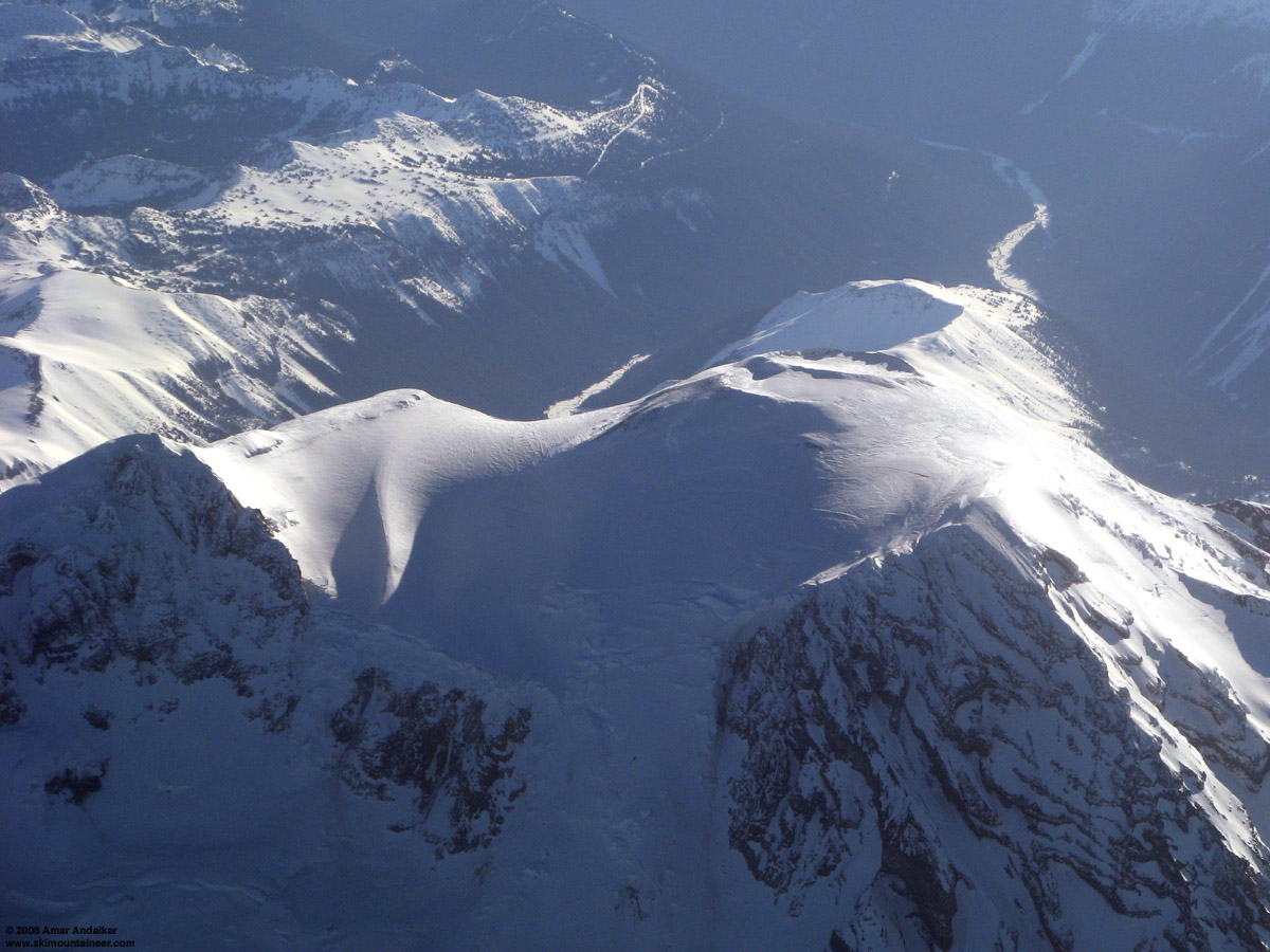
Aerial view from the WSW of the summit region of Mount Rainier including the twin craters and all three summits, taken last year on 12 Apr 2008 from a commercial flight from SeaTac to Tucson.
[hr][tt]MOUNT RAINIER RECREATIONAL FORECAST
NATIONAL WEATHER SERVICE SEATTLE WA
318 AM PDT WED JUL 1 2009
SYNOPSIS...SUNNY AND WARMER WEATHER WILL CONTINUE INTO THE 4TH OF JULY WEEKEND. TEMPERATURES WILL BECOME WELL ABOVE NORMAL. AN UPPER LEVEL TROUGH WILL DEVELOP OFFSHORE ON SUNDAY...KNOCKING TEMPERATURES BACK DOWN TO NORMAL...WITH COOLER CONDITIONS INTO EARLY NEXT WEEK.
WEDNESDAY...SUNNY. FREEZING LEVEL 12500 FEET.
WEDNESDAY NIGHT THROUGH FRIDAY...CLEAR. FREEZING LEVEL NEAR 14000 FEET.
FRIDAY NIGHT AND INDEPENDENCE DAY...MOSTLY CLEAR. FREEZING LEVEL 13000 FEET.
SATURDAY NIGHT...PARTLY CLOUDY. FREEZING LEVEL 12500 FEET.
SUNDAY...PARTLY SUNNY WITH A CHANCE OF SHOWERS. SNOW LEVEL 10500 FEET.
SUNDAY NIGHT...MOSTLY CLOUDY WITH A CHANCE OF SHOWERS. SNOW LEVEL 10500 FEET.
MONDAY THROUGH TUESDAY...MOSTLY CLOUDY WITH A CHANCE OF SHOWERS. SNOW LEVEL 8500 FEET.
TEMPERATURE AND WIND FORECASTS FOR SELECTED LOCATIONS.
WED WED THU THU FRI
NIGHT NIGHT
SUMMIT (14411 FT) 24 23 23 24 25
W 16 W 16 W 23 W 22 SW 23
CAMP MUIR(10188 FT) 44 42 43 44 44
E 6 SW 5 SW 8 SW 12 SW 11
PARADISE (5420 FT) 68 52 74 55 75
E 8 NE 11 SE 8 NE 6 S 9
LONGMIRE (2700 FT) 77 45 81 50 86
CALM CALM CALM CALM CALM
[/tt]
Nice - thanks for sharing.
The consolidation seems great right now, from what we saw on Adams. I love being able to ski such great snow so late in the day.
The consolidation seems great right now, from what we saw on Adams. I love being able to ski such great snow so late in the day.
Thanks Amar!
You continually remind the rest of us just how much is possible!
Bill
Doyle
You continually remind the rest of us just how much is possible!
Bill
Doyle
Wow Amar! I met you on Shasta (splitboarder) last May, the week after your steam vent epic, and haven't really followed your TRs this season until now....looks like your slaying it!
That's a bunch of vertical in a very short time considering you actually took time out to sleep!!!!
Way to continue getting after it, I'll look forward to running into you again one of these days!
That's a bunch of vertical in a very short time considering you actually took time out to sleep!!!!
Way to continue getting after it, I'll look forward to running into you again one of these days!
- Superb, glad you lucked out with the weather, & the aerial photo was another good bonus.
Reply to this TR
Please login first: