July 3, Adams - SW chute
7/15/09
WA Cascades West Slopes South (Mt Rainier)
3496
8
As we drove down 23 on Thursday evening, we could see that the middle chute still went, and the traverse out from the bottom appeared to pretty much go to and a bit below what I think of as "the lip" (the point at which there seem to be many opinions about the best way back). How far below was a somewhat interesting question, but not really consequential as I knew that once on top, we would likely not let a little extra hillside thrash stop us.
We avoided the famed all-night-carnival at Cold Springs by camping in a wonderful little spot partway up the road. I managed more sleep than any of my prior 4 trips on Adams - something like 7 hours! The next day, we talked to parties that had driven in and started hiking at 1, 2, 3, 4, and 6. I'm sure some of those other people had started at 5. We got ourselves walking with a brutal alpine start of 7:30AM. My buddy Paul noted the long days and likely well-consolidated snowpack as reasons to feel good about our sloth. It worked for me.
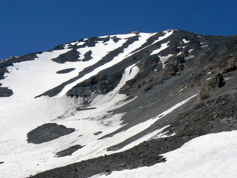
The south climb was looking pretty bumpy for skiing pretty much the whole way. It is always hard to tell from a distance, but the middle SW chute was looking more smooth, and the tracks seemed to suggest linkable turns versus the turn-traverse-turn-repeat pattern on the Pikers Peak headwall.
One of these years I have to go earlier and get the chutes when you can ski more or less to/from Morrison Creek. I'm thinking that the extra climb can't be any more work than returning along the round-the-mountain trail, and what a long run!
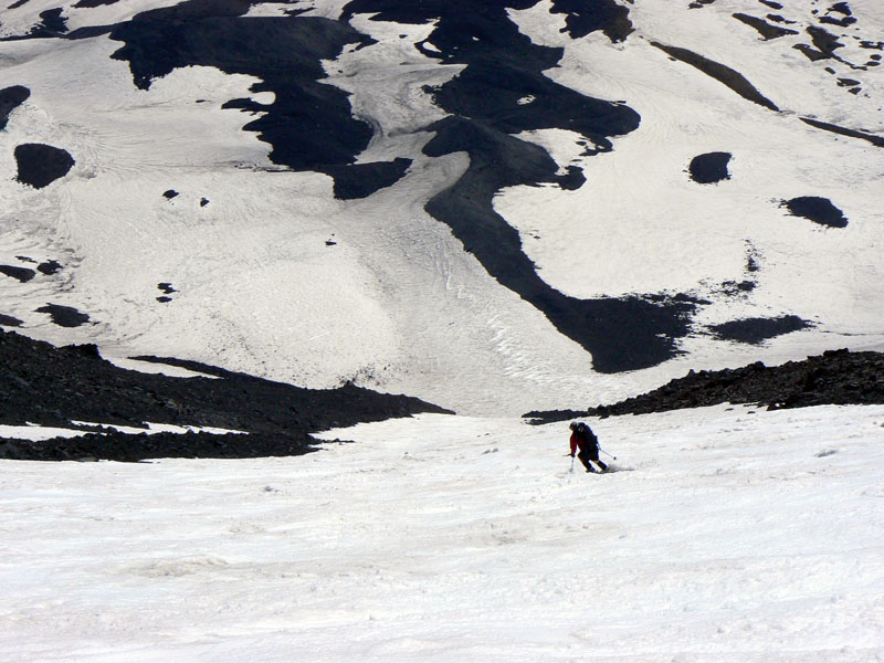
We took several nice leisurely breaks on the way to the summit. I don't recall having previously seen the engraved rock at Pikers Peak - I should have written down what it said, but in any case it was supposedly carved in something like 1929. Makes me curious to see if I can find the story behind it at some point. There were only two people at the summit when we arrived somewhere after 2:30. It was great to have the top to ourselves once they left - that led us to indulge our altitude lassitude a bit and enjoy the views for longer than we'd originally intended. We finally pushed off at about 3:30, and we were both glad to be on the late shift, The run back down to the chutes was way bumpier than it looked from a distance, and so it was nice to have well-softened snow as well as a great highway formed by the more disciplined early-rising skiers. Ten minutes later, we started down the chute, which was pretty smooth, ripe corn. I'd say the most consistent easy skiing I've had in the chutes in 4 trips - I've had even smoother snow, but on those trips it got punchy and then mushy part way down. There were a few horizontal cracks (or linear undermining) forming on the right side of the chute, so we kept alert, but were still pretty much able to let 'er rip! The bottom of the chute was a lot narrower than I'd seen, but went fine. Given all the prior skiers, it was a bit moguled, but there were nice corn moguls and it was pretty fun! At the bottom where the chutes all recombine, it became extremely bumpy, and we were once again glad to be the late shift, as we used the prior tracks along with benevolently-shaped bumps to mostly continue smoothly linking turns, but at a pace dictated by the snow. Our legs were starting to feel it! Despite hearing one rock fall, we decided to follow most of the other tracks out across the rockfall basin (with an eye above as we traversed), and found more linkable turns through delightfully skiable soft corn (keeping an eye out for the major pits from rock-melted-snow here and there) down to where we started the leftward traverse. What a run! Granted, a few spots that were not-awesome turns, but even in the worst spot it beat hiking downhill in my book.
Much better than I'd expected, given all the reports of major cupping and bumpiness from around the state...
We took a nice break down along the traverse at a spot where a cool breeze rushed downhill. We followed the consensus track along the high left traverse to "the lip," and from there followed the rightmost tracks down the convex hump that leads into the creek draw to the south. There were a few ski carries along the traverse and down toward the creek, but aside from that, we were able to ski down a snow finger along the creek (which is undermined by water of course - and there are spots that won't go much longer...) to something like 6,500 (didn't check an altimeter). A short hike down the left side of the creek led us to the round-the-mountain trail where we pulled out our secret weapons - light-but-cushiony running shoes!! I've managed to ski (with two short carries) back to the south climb once, and have hiked out the round-the-mountain trail two other times, both in my ski boots. The running shoes changed it from tedium through which I could notice I was in a beautiful place that I couldn't quite fully enjoy into tired-but-joyful-and-easygoing hiking on a lovely warm evening. We only met one "mountaineer" going in who sniffed in superiority about how we must have had to endure intolerably mushy snow due to our lazy start, who appeared unwilling to believe us that we actually hit the corn about perfectly. It is funny how invested some folks are in the notion of the alpine start. I'll grant, though, that the early risers are getting a great moonset right now. But we had the summit and our entire descent and traverse to the south climb circus to ourselves. We reached the car just after 7, after many short breaks along the bottom of the south climb where we heard about trip plans and shared beta (including telling some skiers not to bother with that 3Am start from high camp unless they just wanted to spend hours up top exploring while waiting for things to melt).
We decided to push for home, and other than hitting a 15 minute delay due to the end of the fireworks celebration in Eatonville, we had nearly empty roads and fast driving. Even with dropping Paul at his car at the Federal Way Park and Ride, I was home 5 hours after leaving Cold Springs.
It seemed like it had been 3 days since we'd started our drive south. I love that feeling.
We avoided the famed all-night-carnival at Cold Springs by camping in a wonderful little spot partway up the road. I managed more sleep than any of my prior 4 trips on Adams - something like 7 hours! The next day, we talked to parties that had driven in and started hiking at 1, 2, 3, 4, and 6. I'm sure some of those other people had started at 5. We got ourselves walking with a brutal alpine start of 7:30AM. My buddy Paul noted the long days and likely well-consolidated snowpack as reasons to feel good about our sloth. It worked for me.
The south climb was looking pretty bumpy for skiing pretty much the whole way. It is always hard to tell from a distance, but the middle SW chute was looking more smooth, and the tracks seemed to suggest linkable turns versus the turn-traverse-turn-repeat pattern on the Pikers Peak headwall.
One of these years I have to go earlier and get the chutes when you can ski more or less to/from Morrison Creek. I'm thinking that the extra climb can't be any more work than returning along the round-the-mountain trail, and what a long run!
We took several nice leisurely breaks on the way to the summit. I don't recall having previously seen the engraved rock at Pikers Peak - I should have written down what it said, but in any case it was supposedly carved in something like 1929. Makes me curious to see if I can find the story behind it at some point. There were only two people at the summit when we arrived somewhere after 2:30. It was great to have the top to ourselves once they left - that led us to indulge our altitude lassitude a bit and enjoy the views for longer than we'd originally intended. We finally pushed off at about 3:30, and we were both glad to be on the late shift, The run back down to the chutes was way bumpier than it looked from a distance, and so it was nice to have well-softened snow as well as a great highway formed by the more disciplined early-rising skiers. Ten minutes later, we started down the chute, which was pretty smooth, ripe corn. I'd say the most consistent easy skiing I've had in the chutes in 4 trips - I've had even smoother snow, but on those trips it got punchy and then mushy part way down. There were a few horizontal cracks (or linear undermining) forming on the right side of the chute, so we kept alert, but were still pretty much able to let 'er rip! The bottom of the chute was a lot narrower than I'd seen, but went fine. Given all the prior skiers, it was a bit moguled, but there were nice corn moguls and it was pretty fun! At the bottom where the chutes all recombine, it became extremely bumpy, and we were once again glad to be the late shift, as we used the prior tracks along with benevolently-shaped bumps to mostly continue smoothly linking turns, but at a pace dictated by the snow. Our legs were starting to feel it! Despite hearing one rock fall, we decided to follow most of the other tracks out across the rockfall basin (with an eye above as we traversed), and found more linkable turns through delightfully skiable soft corn (keeping an eye out for the major pits from rock-melted-snow here and there) down to where we started the leftward traverse. What a run! Granted, a few spots that were not-awesome turns, but even in the worst spot it beat hiking downhill in my book.
Much better than I'd expected, given all the reports of major cupping and bumpiness from around the state...
We took a nice break down along the traverse at a spot where a cool breeze rushed downhill. We followed the consensus track along the high left traverse to "the lip," and from there followed the rightmost tracks down the convex hump that leads into the creek draw to the south. There were a few ski carries along the traverse and down toward the creek, but aside from that, we were able to ski down a snow finger along the creek (which is undermined by water of course - and there are spots that won't go much longer...) to something like 6,500 (didn't check an altimeter). A short hike down the left side of the creek led us to the round-the-mountain trail where we pulled out our secret weapons - light-but-cushiony running shoes!! I've managed to ski (with two short carries) back to the south climb once, and have hiked out the round-the-mountain trail two other times, both in my ski boots. The running shoes changed it from tedium through which I could notice I was in a beautiful place that I couldn't quite fully enjoy into tired-but-joyful-and-easygoing hiking on a lovely warm evening. We only met one "mountaineer" going in who sniffed in superiority about how we must have had to endure intolerably mushy snow due to our lazy start, who appeared unwilling to believe us that we actually hit the corn about perfectly. It is funny how invested some folks are in the notion of the alpine start. I'll grant, though, that the early risers are getting a great moonset right now. But we had the summit and our entire descent and traverse to the south climb circus to ourselves. We reached the car just after 7, after many short breaks along the bottom of the south climb where we heard about trip plans and shared beta (including telling some skiers not to bother with that 3Am start from high camp unless they just wanted to spend hours up top exploring while waiting for things to melt).
We decided to push for home, and other than hitting a 15 minute delay due to the end of the fireworks celebration in Eatonville, we had nearly empty roads and fast driving. Even with dropping Paul at his car at the Federal Way Park and Ride, I was home 5 hours after leaving Cold Springs.
It seemed like it had been 3 days since we'd started our drive south. I love that feeling.
Sounds like a nice day for sure. In June we tried to start early but didn't. :)
Would the chutes still be worth it next weekend? It's supposed to be cooler all week.
And do you know which creek you used to hit the ATM trail?
cheers
Would the chutes still be worth it next weekend? It's supposed to be cooler all week.
And do you know which creek you used to hit the ATM trail?
cheers
Dunno how fast it will melt. If I were going next weekend, I'd want a backup plan (e.g. buck up and ski the bumps on the s. climb - still prolly better than hiking and may be getting big enough to be like inverse moguls :D), and I'd want to scope the line from down below to see if the central chute was still continuous (easily done on the road from getting a permit at Trout Lake, as well as along FR 23, as long as you have daylight. I'd also look at the traverse at the bottom (goes skier's left for a bit) seemed fairly snowy, unless you don't care about a fair bit of extra volcanic talus travel. Seemed like it was pretty deep there. Seems like there's a fair chance it would be OK for at least another week, but I really don't know its typical meltout pattern. There will certainly be a bit more carrying down lower, and the bottom snow toungue will almost certainly no longer be worth skiing due to rocky (and creeky) gaps (but it's hikeable). Might be more deeply steeply bumped down low, which could be intriguing - nothing a good attitude and some time wouldn't handle. We descended the creek that drains that oval flat the map shows beneath the chutes. My bet is that you'll still be able to ski to the bottom edge of the oval but not much if any further, but for all I know it will be much more grim than that.
I have always thought that the late-riser's club gets it good. We get used to the heat on the climbs, and we get lots of solitude on the descents.
I have always thought that the late-riser's club gets it good. We get used to the heat on the climbs, and we get lots of solitude on the descents.
Hi Folks - I had the delightful honor of accompanying Jim on this epic ski adventure, and the attached photos will hopefully provide some additional data points on the snow conditions... I hope that you also get to experience the unique Joy of Christmas in July - whoo hoo! coreski
author=Jim Oker link=topic=13778.msg57571#msg57571 date=1246734350]There were a few ski carries along the traverse and down toward the creek, but aside from that, we were able to ski down a snow finger along the creek (which is undermined by water of course - and there are spots that won't go much longer...) to something like 6,500 (didn't check an altimeter).
That was definitely the way to do it. Unfortunately, on Saturday I followed the herd and de-skied at the base of that broad (and very dirty) face, then hiked down the steep side of the creek. On Sunday, I skied all the way to the end of the snow in the creek (to 6,400 according to my waypoint), which was much faster.
Yeah, it took a little faith to put skis back on after the short carry from the bottom of the dirty face (on which I turned in the white patches). It was hard to see if the next snowpatch went past the first creek constriction, but I decided even that was worth it to save my legs from a little steep downhiking even if not from a time saving perspective. When I saw that it went further... and kept going... SCORE!! Thanks for using the altimeter - I wondered afterwards how low I'd skied. I lied above - Core hiked like you did on Saturday and regretted it, but I didn't mind resting while waiting for him...
I don't know about you, but there were a few moments for me where I had to have faith that the snow wouldn't collapse.
You did it two days in a row? Awesome! Not sure I'd have been up for it.
I don't know about you, but there were a few moments for me where I had to have faith that the snow wouldn't collapse.
You did it two days in a row? Awesome! Not sure I'd have been up for it.
I have lots of experience with potentially undermined snow in the Presidentials back home, so I was quite confident that the snow would support me on skis . . . well, except for this one final connecting section, but any possible drop looked trivial.
Two Adams summit runs two days in a row was relatively easy after getting acclimated on the summit of Rainier the prior day. We spent almost an hour and a half up there. The next two days on the Adams summit, I felt like I was at sea level back home!
Two Adams summit runs two days in a row was relatively easy after getting acclimated on the summit of Rainier the prior day. We spent almost an hour and a half up there. The next two days on the Adams summit, I felt like I was at sea level back home!
Yeah - I'm sure that's it. If only I'd skied Rainier on Wednesday/Thursday, I'm sure I'd have been feeling fresh as a daisy on Saturday morning and ready for another 7K of gain! Thanks for the out-of-the-box tip! ;)
Presis - if we run across each other someday I'd love to pick your brain out of curiosity if you've don't lots of skiing beyond the same-old-same-old. I was just moving from XC and alpine into telemark when we moved away from MA, so I'd done some of the more obvious and entry-level things like Sherburne/Tucks, and some other new england tours (Camel's Hump multiple times - loved the moderate birch glades as I was learning! partway up Chocurua, but hit ice up higher so bailed, etc.). But it seemed that with a bit more skill and willingness to explore, there would be interesting options in the presis - e.g. places like King's Ravine and other non-Tuck's bowls that lie in cool spots - as well perhaps as in the Franconias. I don't expect to be heading up there to get any of it (trips back tend to be all about a mix of work and family visiting), but would be curious to hear from folks who have explored there a bit.
Presis - if we run across each other someday I'd love to pick your brain out of curiosity if you've don't lots of skiing beyond the same-old-same-old. I was just moving from XC and alpine into telemark when we moved away from MA, so I'd done some of the more obvious and entry-level things like Sherburne/Tucks, and some other new england tours (Camel's Hump multiple times - loved the moderate birch glades as I was learning! partway up Chocurua, but hit ice up higher so bailed, etc.). But it seemed that with a bit more skill and willingness to explore, there would be interesting options in the presis - e.g. places like King's Ravine and other non-Tuck's bowls that lie in cool spots - as well perhaps as in the Franconias. I don't expect to be heading up there to get any of it (trips back tend to be all about a mix of work and family visiting), but would be curious to hear from folks who have explored there a bit.
I really do think skiing Rainier Th/Fr put me in great shape for Adams on Sat & Sun, especially since we took it super-slow to Camp Schurman on Thursday (about six hours) and then Friday to the summit really just isn't that big of a day since Camp Schurman positions you so close. All that acclimation just me feel great on Adams. (Too bad I'm back now at sea level for the foreseeable future!)
The Presis do have many (many) options beyond Tux, although then again, compared to the PNW, the above-treeline terrain is absurdly limited.
Here's the entire skiable Southern Presidentials (except for Huntington, which I'd skied two days earlier, with not much left), in a single day:
http://picasaweb.google.com/jshefftz/20090430Everything#5330678744402213010
And here's the entire skiable Northern Presidentials in a single weekend:
http://picasaweb.google.com/jshefftz/20090425CastleRavineJeffersonRavine
http://picasaweb.google.com/jshefftz/20090426KR
Reply to this TR
Please login first: