6/27/09 Tokaloo Rock/Puyallup Clvr-ride, hike, ski
6/27/09
4084
10
Having a broken down car and a desire to ski the mountains means that one must be willing to adopt alternative methods of travel. Living in Seattle affords one with many options for transport. Snowbell offered to drive, and as he lives in Bremerton, this meant that I needed to ride the ferry. Down the hill I went. Stares from the Underground tour-goers were entertaining as they saw that guy riding the mountain bike with the skis on his pack. The ride over was quite nice with the sun setting and colors lighting up Puget Sound. This was an interesting beginning to a fun trip, I thought to myself.
Arriving in Bremerton, Snowbell picked me up and after a few short detours we were on our way. He informed me that our sponsor was waiting for us at his house and that we would stop by to get his endorsement as well as some swag. Scotsman being a good sponsor provided a few well-needed drinks of water and booze and provoked an arm wrestling match, the winner of which deciding what tour would be taken. When it was all over we decided that we were headed out to the Saint Andrews lake and Tokaloo Spire area with the option of continuing up the Puyallup Cleaver.
The approach requires either mountain biking 12 miles out to Klapatche Park Trailhead then another 3+ mile hike to Saint Andrews Lake, or a 3+ mile ride out to the South Puyallup River Trail, then a 1.6 mile hike to the Wonderland trail cutoff, with a 3+ mile hike to St Andrews Lake. We decided on forgoing the long bike ride and went with the latter. My only concerns were ones that arose from a backpacking trip to the area two years ago; blowdowns and washed out road on the Westside road, and blowdowns on the Wonderland Trail. Both of which turned out to be moot points as the road and trail went as smoothly as can be. The road seemed like it would be pretty easily drivable with a higher clearance vehicle. I wonder if they have purposely kept the area much less accessible so that the more wilderness needing animals see less human activity.
We began the bike ride at 3 am to the sounds of some very inviting wolves? howling and roughhousing somewhere off in the distance. Headlamps illuminated the road, which was actually very easily traveled on mountain bike given the limited visibility. We made good time to the S. Puyallup River trail and were rewarded with a sunrise slowly emerging, illuminating the massive columnar basalt formation along the trail. Made great time to the Puyallup River and Wonderland Trail split, and off we went- up the switchbacks towards the ridge. As we gained elevation we encountered more slide paths and snow covered trail. This made for interesting side hilling to regain the trail and probably would have been best done straight up- with crampons and axe in hand. The freeze overnight allowed for a firm surface and boded well for a corn ski later.
We arrived at the ridge and climbed until we could see St. Andrews Lakes source and the surrounding basin. This was the area I remember discovering two years ago while backpacking at the same time of year- Andrew Peak, Tokaloo rock and spire and their hillslopes all spilling down at perfectly skiable angles. Better yet, all these slopes are NW to W facing and hold copious amounts of snow while avoiding the travel complications glaciers provide. The slope down from Tokaloo Rock looked perfect and we discussed that as an option to ski once things softened up. While waiting for the slopes to soften we gathered water from the source lake and took a much needed nap in the treed ridgeline, just NE of St. Andrews Lake.
When we woke the slopes were nicely softened which made for easy booting and skinning. We gained the ridge above Andrew (6716) and decided that we would continue to climb along the ridgeline in order to see the lay of the land along both sides. Previous travelers had approached this area straight up the gut and up to Tokaloo Spire, but we wanted to give ourselves the advantage of scouting the lay of the land.
As we were making fantastic time, feeling strong, and rested after out short nap, we decided we had plenty of daylight ahead of us and forged ahead towards the Puyallup Cleaver. Rounding Tokaloo spire and contouring along the ridgeline towards the Cleaver, we saw some amazing jumbles of ice and rock along both the Puyallup and Tahoma glaciers. We continued up to just below the lower cleaver. I topped out near 8,000 feet while Joe decided to continue up to near 9k. This involved a few rock moves and was quite an impressive line waiting to be skied below. We could have approached the same line from the gut but were on the ridge and did not want to lose elevation or risk booting up and into a crack. Joe topped out a bit below point 8966. Before he had continued on ahead of me, we decided to change up our route and instead ski the slopes near 8966, down onto the Tahoma glacier, then work our way to where the western Tahoma splits in a v-shape and gain the South Puyallup river trail via the moraine. To experience the journey was purpose of the day, not the skiing, as evidenced by our bike, hike, tour, and short ski.
We skied the slope in alternating, smooth, grabby, suncupped, overdone snow conditions until we encountered cliffs below blocking our descent down. This was the area just below the flat area (at 7k) just off of the NW side of the Tahoma glacier (from 6,800 to 6,200). Cutting hard skiers right and down climbing some rock and heather bypassed this area before we dropped back onto the snowfield. We then had to cross the Tahoma terminus, and was likely the only glaciated terrain we touched. We made our way through the massive piles of rock and debris that covered the lower slopes of the glacier, encountering a few cracks along the way. We stayed skiers right of 6032 in order to position ourselves for an easier hike up the moderately sloped lateral moraine. Made it up onto the moraine then onto the S. Puyallup river trail for a long hike and bike out on a beautiful day at Rainier. We walked down and transitioned to bikes, realizing the worst was not over yet¦ the previous night we flew down the road from Round Pass after a long ride up and realized we needed to do it all again. It is amazing what a few gummi bears can do to perk you up for the strenuous ride uphill, but we flew up, powered by gummi bears, and enjoyed the ride down from Round Pass (Marine Crash Site Memorial). Lots of hikers on the road (that we never saw all day) looked quite surprised to see two guys with skis on backs barreling down the road.
We closed out the day by Joe getting me to the ferry terminal just in time for me to ride onto the boat, the last passenger arriving to cries from the bystanders of go, go, go! Having made it onto the boat, I relished my second sunset in 24 hours and gaped at Rainer from across the Sound, wow¦ was all that I could muster. The final leg of my journey was the ride/ hike 250 vf up to my condo. Having arrived home after such a long journey, I could only think of how lucky we all are to be enjoying such wonderful surroundings.
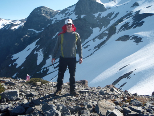
Photo1- Rest spot just above St. Andrews Lake. Tokaloo peak behind and to the right (not in pic) holds many lines to ski.
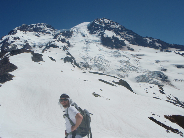
Photo 2- Joe before Tokaloo Spire. In the distance is pt 8966 of which Joe skied off the lower section.
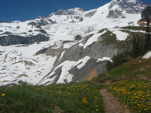
Photo 3- From the S. Puyallup River Trail. In left side of picture with waterfall is where we were cliffed out. Route out not pictured, but is lookers left of this.
more pics- http://picasaweb.google.com/lh/photo/Bp9as9ssvUvJxH-qBRCrAw?feat=directlink
Arriving in Bremerton, Snowbell picked me up and after a few short detours we were on our way. He informed me that our sponsor was waiting for us at his house and that we would stop by to get his endorsement as well as some swag. Scotsman being a good sponsor provided a few well-needed drinks of water and booze and provoked an arm wrestling match, the winner of which deciding what tour would be taken. When it was all over we decided that we were headed out to the Saint Andrews lake and Tokaloo Spire area with the option of continuing up the Puyallup Cleaver.
The approach requires either mountain biking 12 miles out to Klapatche Park Trailhead then another 3+ mile hike to Saint Andrews Lake, or a 3+ mile ride out to the South Puyallup River Trail, then a 1.6 mile hike to the Wonderland trail cutoff, with a 3+ mile hike to St Andrews Lake. We decided on forgoing the long bike ride and went with the latter. My only concerns were ones that arose from a backpacking trip to the area two years ago; blowdowns and washed out road on the Westside road, and blowdowns on the Wonderland Trail. Both of which turned out to be moot points as the road and trail went as smoothly as can be. The road seemed like it would be pretty easily drivable with a higher clearance vehicle. I wonder if they have purposely kept the area much less accessible so that the more wilderness needing animals see less human activity.
We began the bike ride at 3 am to the sounds of some very inviting wolves? howling and roughhousing somewhere off in the distance. Headlamps illuminated the road, which was actually very easily traveled on mountain bike given the limited visibility. We made good time to the S. Puyallup River trail and were rewarded with a sunrise slowly emerging, illuminating the massive columnar basalt formation along the trail. Made great time to the Puyallup River and Wonderland Trail split, and off we went- up the switchbacks towards the ridge. As we gained elevation we encountered more slide paths and snow covered trail. This made for interesting side hilling to regain the trail and probably would have been best done straight up- with crampons and axe in hand. The freeze overnight allowed for a firm surface and boded well for a corn ski later.
We arrived at the ridge and climbed until we could see St. Andrews Lakes source and the surrounding basin. This was the area I remember discovering two years ago while backpacking at the same time of year- Andrew Peak, Tokaloo rock and spire and their hillslopes all spilling down at perfectly skiable angles. Better yet, all these slopes are NW to W facing and hold copious amounts of snow while avoiding the travel complications glaciers provide. The slope down from Tokaloo Rock looked perfect and we discussed that as an option to ski once things softened up. While waiting for the slopes to soften we gathered water from the source lake and took a much needed nap in the treed ridgeline, just NE of St. Andrews Lake.
When we woke the slopes were nicely softened which made for easy booting and skinning. We gained the ridge above Andrew (6716) and decided that we would continue to climb along the ridgeline in order to see the lay of the land along both sides. Previous travelers had approached this area straight up the gut and up to Tokaloo Spire, but we wanted to give ourselves the advantage of scouting the lay of the land.
As we were making fantastic time, feeling strong, and rested after out short nap, we decided we had plenty of daylight ahead of us and forged ahead towards the Puyallup Cleaver. Rounding Tokaloo spire and contouring along the ridgeline towards the Cleaver, we saw some amazing jumbles of ice and rock along both the Puyallup and Tahoma glaciers. We continued up to just below the lower cleaver. I topped out near 8,000 feet while Joe decided to continue up to near 9k. This involved a few rock moves and was quite an impressive line waiting to be skied below. We could have approached the same line from the gut but were on the ridge and did not want to lose elevation or risk booting up and into a crack. Joe topped out a bit below point 8966. Before he had continued on ahead of me, we decided to change up our route and instead ski the slopes near 8966, down onto the Tahoma glacier, then work our way to where the western Tahoma splits in a v-shape and gain the South Puyallup river trail via the moraine. To experience the journey was purpose of the day, not the skiing, as evidenced by our bike, hike, tour, and short ski.
We skied the slope in alternating, smooth, grabby, suncupped, overdone snow conditions until we encountered cliffs below blocking our descent down. This was the area just below the flat area (at 7k) just off of the NW side of the Tahoma glacier (from 6,800 to 6,200). Cutting hard skiers right and down climbing some rock and heather bypassed this area before we dropped back onto the snowfield. We then had to cross the Tahoma terminus, and was likely the only glaciated terrain we touched. We made our way through the massive piles of rock and debris that covered the lower slopes of the glacier, encountering a few cracks along the way. We stayed skiers right of 6032 in order to position ourselves for an easier hike up the moderately sloped lateral moraine. Made it up onto the moraine then onto the S. Puyallup river trail for a long hike and bike out on a beautiful day at Rainier. We walked down and transitioned to bikes, realizing the worst was not over yet¦ the previous night we flew down the road from Round Pass after a long ride up and realized we needed to do it all again. It is amazing what a few gummi bears can do to perk you up for the strenuous ride uphill, but we flew up, powered by gummi bears, and enjoyed the ride down from Round Pass (Marine Crash Site Memorial). Lots of hikers on the road (that we never saw all day) looked quite surprised to see two guys with skis on backs barreling down the road.
We closed out the day by Joe getting me to the ferry terminal just in time for me to ride onto the boat, the last passenger arriving to cries from the bystanders of go, go, go! Having made it onto the boat, I relished my second sunset in 24 hours and gaped at Rainer from across the Sound, wow¦ was all that I could muster. The final leg of my journey was the ride/ hike 250 vf up to my condo. Having arrived home after such a long journey, I could only think of how lucky we all are to be enjoying such wonderful surroundings.
Photo1- Rest spot just above St. Andrews Lake. Tokaloo peak behind and to the right (not in pic) holds many lines to ski.
Photo 2- Joe before Tokaloo Spire. In the distance is pt 8966 of which Joe skied off the lower section.
Photo 3- From the S. Puyallup River Trail. In left side of picture with waterfall is where we were cliffed out. Route out not pictured, but is lookers left of this.
more pics- http://picasaweb.google.com/lh/photo/Bp9as9ssvUvJxH-qBRCrAw?feat=directlink
That's what I'm talking about ! A long overdue report from that Area.
Thanks guys! I betcha I reread that 3 times.
Should read Ferry,drive, bike,hike, ski
Thanks guys! I betcha I reread that 3 times.
Should read Ferry,drive, bike,hike, ski
I've always wondered about that area.
Nice work guys ;)
Nice work guys ;)
author=Robie link=topic=13727.msg57334#msg57334 date=1246241914]
That's what I'm talking about ! A long overdue report from that Area.
Thanks guys! I betcha I reread that 3 times.
Should read Ferry,drive, bike,hike, ski
Agreed, long overdue- I had been thinking about skiing that area for the past 2 years. Happy we made it happen. Thanks to Joe for pushing the idea further. I posted a few more pics on picassa. Sorry that some important pics are missing (ie- the slopes of Tokaloo, and some skiing...), my camera has been acting up. Maybe Joe will hunker down and bear the extra weight of another camera as backup for once.
about 4 yrs ago Jeff Spann and I did it as a bike /hike .Hiking from Klapachie. I can see it from my house in Sumner and it just drives me batty. again good job!
Excellent boys. I'm a proud Sponsor although I was a bit concerned watching the pair of you arm wrestle at my house over route selection. Lucky you won Chris as SnowBell had a heinous crevasse ridden tour planned if you had lost. ;D
Need to get out there. How long will the skiing last you think?
Need to get out there. How long will the skiing last you think?
author=Scotsman link=topic=13727.msg57343#msg57343 date=1246248122]
Excellent boys. I'm a proud Sponsor although I was a bit concerned watching the pair of you arm wrestle at my house over route selection. Lucky you won Chris as SnowBell had a heinous crevasse ridden tour planned if you had lost. ;D
Need to get out there. How long will the skiing last you think?
Yeah, judging by the crevasses evident out on the Tahoma and elsewhere, it may have been a pretty difficult route to follow had I lost the arm wrestling match.
The skiing off of Tokaloo Spire and Rock should be good for several weeks all the way from near the summit. The route we took down onto the lower Tahoma will be melted out pretty soon, but the rest is glacier free travel, not much to worry about in terms of exposure to crevasses otherwise. The route from 7k down around the cliffed out portion could be some additional rock downclimbing pretty soon.
Glad to hear you all had a good time at Sunrise.
Awesome trip. Have been contemplating that very same.
How long you figure it took you car to car?
How long you figure it took you car to car?
author=wolfs link=topic=13727.msg57351#msg57351 date=1246254873]
Awesome trip. Have been contemplating that very same.
How long you figure it took you car to car?
We could have done it a bit faster (no nap, wasted some time descending to get water...) but took us ~15 hours.
author=skierlyles link=topic=13727.msg57346#msg57346 date=1246249528]
I cheated and stacked up on Joe nearly breaking his arm because it was obvious that I could not beat him in a fair arm wrestling match. Sorry Joe
That was not necessary Chris but thank you for setting the record straight. Really it was our sponsor's fault. Feeding us screwdrivers just before a long tour when our original agreement required rum and coke? I hope he learned a lesson and that we can move forward in a renewed and refocused spirit of cooperation. (thanks for the screwdrivers btw ;))
The fall line below Tokaloo rock will hold for awhile and looks great for at least a couple thousand feet. The other line that stood out to me (aside from the one that I skied) was just above Glacier Island. A very nice snowfield is holding well there and would be worth the effort. To spend a few days up there in the winter could be epic.
...and the list grows longer. I tick one off and find three more while in the process.
Nice work you guys.
Reply to this TR
Please login first: