5/28 From Cayuse to the Cowlitz Chimney and beyond
5/28/09
WA Cascades West Slopes South (Mt Rainier)
5077
11
The Cowlitz Chimneys is another one of those lines that Crystal Locals drool at from the top of the King. There have been multiple occasions where Ive had discussions with patrollers about accessing the Giant. Originally I had planned on getting out there right after the opening of Cayuse pass but for one reason or another that didnt happen.
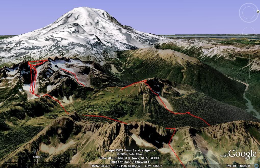
When people think of Mount Rainier National Park the first place that pops into there mind is Paradise but for me the best area and place where I would call home is the NE/E side of the park. The East side boasts more then a few massive peaks with crowds that are 1/10 the size of the crowds at Paradise. I had been toying with the idea of coming up with a circumference tour starting out at Cayuse and ending up at the White river road via the Sarvant glacier and if the time span and route worked out I was going for it.
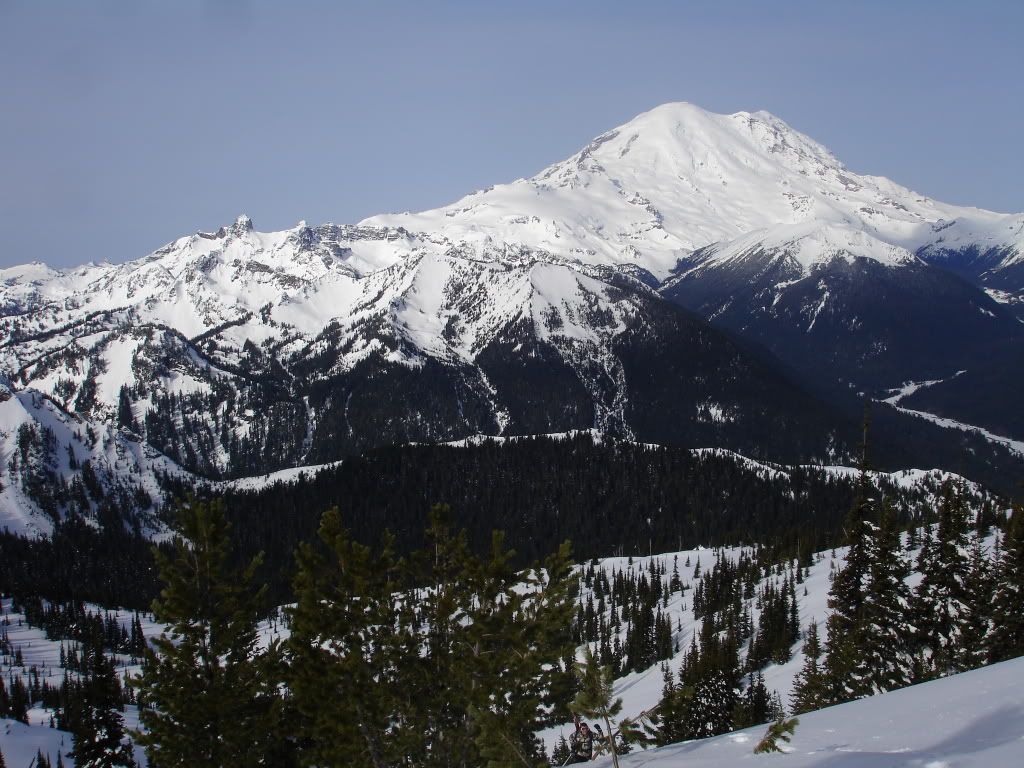
Governor Ridge in the Foreground with the Cowlitz Chimneys behind it
I started at Cayuse pass around 8:00 in the morning and hiked 600 feet up to the pass just south of sheep skull gap. From the gap I made a downhill traverse east to around 4800 feet where I switched over to skins for an ascent up Governor Ridge. I was able to find a low col in the Alpine bowl just North of Barrier peak which gave me access to the Owyhigh lakes valley to the East. From 6200 I was able to take a 1000 vert run down to Owyhigh Lake where I took a quick break and refilled on both calories and Water.
From Owyhigh Lake I skinned south to a ridge that Separated Barrier peak to the North and the Cowlitz chimneys to the south. By now wet slides were becoming a concern so I decided the safest way to climb the ridge was to go up a slope that had already slid and had minimal/ no exposure. So after finding a feasible area I switched over to bootpacking and climbed 700 feet up to the ridge. From the ridge I got my first up close view of the Chimneys which was filled with avi chunder. Normally I wouldnt be stoked on this but with the conditions the way they were I was happy to see that it had already slid. I was somewhat lucky that I had climbed up where I did which was one of the only places where I could ride down with no exposure so I carefully rode down the 300 feet making sure not to get nailed by any wetslides along the way.
Finally I was at the base of the Cowlitz chimney. For years I had wanted to ride this aesthetic line and know it was easily in my grasp. The crux area was steep so I decided I would bootpack the 1800 vert to the summit right up the pre slid terrain. I had given myself a timeline that if I didnt reach I would have to turn around and that timeline was an hour so I ran up the chute in 50 minutes. From the col I did some rock scrambling up to the high point at around 7400 feet to check out conditions on the Sarvant Glacier and Tamanos Mountain all of which looked fine. So I rode down the chimney back to my original starting point taking a few turns on steep slopes then traversing to safe spots with no exposure along the way. The ride down was quite enjoyable and to make thing better I had a bootpack back up the chimneys which saved me some time.
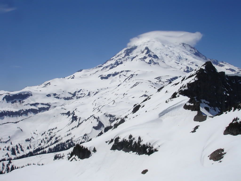
The View of Rainier and Ohanapecosh from the Cowlitz Chimney col
At the top of the col I made a 500 vert traverse east and boot packed up 100 feet to a low col accessing the Sarvant Glacier. The Sarvant was a amazing low angle, perfect corn snow run that ran for 2000 vert (this place would be a dream during the winter) where I took another quick break to refill on water and calories. I had rode from 7200 feet all the way to 5200 feet and was sitting at the base of Tamanos Mountain where I would ascend up a low saddle and get the summit. By know my boots were soaked from all the bootpacking so I decided I would skin until the terrain became too steep for comfort (I was still spooked from the wetslide slab earlier in the week). Conditions on the west slope were perfect for skinning not too wet and not too firm so I was able to skin all the way to the col then the summit of Tamanos where I got amazing views in every direction.
From the top of Tamanos I spotted a sweet looking chute (thanks boot) on the NE face that rode all the way down to a trail that I would be able to ride all the way to the white river. Conditions in the chute were great by the time I dropped in the snow and had refrozen but was still carve able and had minimal sluff. I ripped down occasionally stopping in a safe spot letting the sluff run by for 1400 feet until riding to a flat basin where it met up with the trail. Trails are almost impossible to spot when they are covered in a five foot snowpack and this was the case. After checking my map I made the decision I would ride down to Shaw creek and follow it to the White River road. I was stoked I had found a drainage that went perfectly to the creek and as I dropped around 700 feet I started hearing a noise you never want to hear when riding a drainage. It was a waterfall and with closer inspection it was big enough that I wasnt going to down climb it.
By know it was around 7:45 and though I was close to being done I needed to start moving so I wasnt bushwhacking in the dark. I put my board on my back and traversed north through the woods slowly loosing elevation along the way. Its weird to say it but I was happy to be bushwhacking, it reminded me that I was back home in Washington (the bushwhacking capital) and how different the forest diversety was from the forests of the backside of Crystal (also in MRNP). After about fifteen minutes I was able to access Shaw creek and with a few small hops here and there I walked all the way down to the white river road. I was stoked the tour was over and I had made it out before it was dark Mission accomplished.
WRONG!
My car was up at Cayuse but I was sure that someone would pick me up along the way. The 3 mile hike to the junction of 410 was uneventful as not a single car came by. By the time I made it to 410 it was dark but the moon was providing enough light to make travel easy. I would just keep moving and stick out my thumb when a car came by. Now I didnt expect anyone to pick me up and I put myself in the situation not anyone else, but its just wrong to stop on the side of the road then drive off as I get close to the car and this happened more then once ( I think it was the snowboard ). Long story short it was an additional 4 miles back to the car which I arrived at around 10:30.
Trip Stats
Ascent/Decent 10,500 feet
Around 11 miles + 7 miles back to the car.
This is an amazing tour and if you have the time and energy I highly recommend it but the route may be melting out soon. So if you go for it you better hurry
Same TR with some amazing scenery of the east side of the park and some great beta ;)
[quote author=Marcus link=topic=13471.msg56129#msg56129 date=1243548389]
Dude... robust. That's a big day.
We skied the Chimneys last June sometime, coming in via Frying Pan. What a great tour. It's such a beautiful area and when I realized that you could see it from Crystal I was a little surprised.
EDIT -- think you could make your pics just a smidge smaller? I can't get the full effect all on my tiny screen here at work.
I mean at home. Yes, I'm not looking at TAY while I'm at work. Nope.
Honestly I dont know how to switch the photo size other then Adobe photoshop which isn't on the computer Im using
and I just notice I put up 5/28. That would mean that Im doing it right now. My Bad it 5/27
When people think of Mount Rainier National Park the first place that pops into there mind is Paradise but for me the best area and place where I would call home is the NE/E side of the park. The East side boasts more then a few massive peaks with crowds that are 1/10 the size of the crowds at Paradise. I had been toying with the idea of coming up with a circumference tour starting out at Cayuse and ending up at the White river road via the Sarvant glacier and if the time span and route worked out I was going for it.
Governor Ridge in the Foreground with the Cowlitz Chimneys behind it
I started at Cayuse pass around 8:00 in the morning and hiked 600 feet up to the pass just south of sheep skull gap. From the gap I made a downhill traverse east to around 4800 feet where I switched over to skins for an ascent up Governor Ridge. I was able to find a low col in the Alpine bowl just North of Barrier peak which gave me access to the Owyhigh lakes valley to the East. From 6200 I was able to take a 1000 vert run down to Owyhigh Lake where I took a quick break and refilled on both calories and Water.
From Owyhigh Lake I skinned south to a ridge that Separated Barrier peak to the North and the Cowlitz chimneys to the south. By now wet slides were becoming a concern so I decided the safest way to climb the ridge was to go up a slope that had already slid and had minimal/ no exposure. So after finding a feasible area I switched over to bootpacking and climbed 700 feet up to the ridge. From the ridge I got my first up close view of the Chimneys which was filled with avi chunder. Normally I wouldnt be stoked on this but with the conditions the way they were I was happy to see that it had already slid. I was somewhat lucky that I had climbed up where I did which was one of the only places where I could ride down with no exposure so I carefully rode down the 300 feet making sure not to get nailed by any wetslides along the way.
Finally I was at the base of the Cowlitz chimney. For years I had wanted to ride this aesthetic line and know it was easily in my grasp. The crux area was steep so I decided I would bootpack the 1800 vert to the summit right up the pre slid terrain. I had given myself a timeline that if I didnt reach I would have to turn around and that timeline was an hour so I ran up the chute in 50 minutes. From the col I did some rock scrambling up to the high point at around 7400 feet to check out conditions on the Sarvant Glacier and Tamanos Mountain all of which looked fine. So I rode down the chimney back to my original starting point taking a few turns on steep slopes then traversing to safe spots with no exposure along the way. The ride down was quite enjoyable and to make thing better I had a bootpack back up the chimneys which saved me some time.
The View of Rainier and Ohanapecosh from the Cowlitz Chimney col
At the top of the col I made a 500 vert traverse east and boot packed up 100 feet to a low col accessing the Sarvant Glacier. The Sarvant was a amazing low angle, perfect corn snow run that ran for 2000 vert (this place would be a dream during the winter) where I took another quick break to refill on water and calories. I had rode from 7200 feet all the way to 5200 feet and was sitting at the base of Tamanos Mountain where I would ascend up a low saddle and get the summit. By know my boots were soaked from all the bootpacking so I decided I would skin until the terrain became too steep for comfort (I was still spooked from the wetslide slab earlier in the week). Conditions on the west slope were perfect for skinning not too wet and not too firm so I was able to skin all the way to the col then the summit of Tamanos where I got amazing views in every direction.
From the top of Tamanos I spotted a sweet looking chute (thanks boot) on the NE face that rode all the way down to a trail that I would be able to ride all the way to the white river. Conditions in the chute were great by the time I dropped in the snow and had refrozen but was still carve able and had minimal sluff. I ripped down occasionally stopping in a safe spot letting the sluff run by for 1400 feet until riding to a flat basin where it met up with the trail. Trails are almost impossible to spot when they are covered in a five foot snowpack and this was the case. After checking my map I made the decision I would ride down to Shaw creek and follow it to the White River road. I was stoked I had found a drainage that went perfectly to the creek and as I dropped around 700 feet I started hearing a noise you never want to hear when riding a drainage. It was a waterfall and with closer inspection it was big enough that I wasnt going to down climb it.
By know it was around 7:45 and though I was close to being done I needed to start moving so I wasnt bushwhacking in the dark. I put my board on my back and traversed north through the woods slowly loosing elevation along the way. Its weird to say it but I was happy to be bushwhacking, it reminded me that I was back home in Washington (the bushwhacking capital) and how different the forest diversety was from the forests of the backside of Crystal (also in MRNP). After about fifteen minutes I was able to access Shaw creek and with a few small hops here and there I walked all the way down to the white river road. I was stoked the tour was over and I had made it out before it was dark Mission accomplished.
WRONG!
My car was up at Cayuse but I was sure that someone would pick me up along the way. The 3 mile hike to the junction of 410 was uneventful as not a single car came by. By the time I made it to 410 it was dark but the moon was providing enough light to make travel easy. I would just keep moving and stick out my thumb when a car came by. Now I didnt expect anyone to pick me up and I put myself in the situation not anyone else, but its just wrong to stop on the side of the road then drive off as I get close to the car and this happened more then once ( I think it was the snowboard ). Long story short it was an additional 4 miles back to the car which I arrived at around 10:30.
Trip Stats
Ascent/Decent 10,500 feet
Around 11 miles + 7 miles back to the car.
This is an amazing tour and if you have the time and energy I highly recommend it but the route may be melting out soon. So if you go for it you better hurry
Same TR with some amazing scenery of the east side of the park and some great beta ;)
[quote author=Marcus link=topic=13471.msg56129#msg56129 date=1243548389]
Dude... robust. That's a big day.
We skied the Chimneys last June sometime, coming in via Frying Pan. What a great tour. It's such a beautiful area and when I realized that you could see it from Crystal I was a little surprised.
EDIT -- think you could make your pics just a smidge smaller? I can't get the full effect all on my tiny screen here at work.
I mean at home. Yes, I'm not looking at TAY while I'm at work. Nope.
Honestly I dont know how to switch the photo size other then Adobe photoshop which isn't on the computer Im using
and I just notice I put up 5/28. That would mean that Im doing it right now. My Bad it 5/27
Dude... robust. That's a big day.
We skied the Chimneys last June sometime, coming in via Frying Pan. What a great tour. It's such a beautiful area and when I realized that you could see it from Crystal I was a little surprised.
EDIT -- think you could make your pics just a smidge smaller? I can't get the full effect all on my tiny screen here at work.
I mean at home. Yes, I'm not looking at TAY while I'm at work. Nope.
Nice day Kyle, that's some serious work you've been throwing down! You got any volcano tr's coming up? Nice work. I've still got your harness too.
SWEEEET kyle .... great effort ... you're an animal!! love the pix of rarely seen stuff in that area this time of year ... thx for the ride :)
Not that I am of this caliber, but I have been daydreaming of a tour like this for the last two years since I first visited the east side contemplating all the options. Way to go! Thanks for the "map" as well. Someday, someday, it'll be my turn, too. :)
author=Kyle Miller link=topic=13471.msg56128#msg56128 date=1243547874]
When people think of Mount Rainier National Park the first place that pops into there mind is Paradise but for me the best area and place where I would call home is the NE/E side of the park. The East side boasts more then a few massive peaks with crowds that are 1/10 the size of the crowds at Paradise.
You're right about the NE/E side of the park, especially right after Cayuse opens. Great TR and photos especially the Google map of your route. Now you can understand why Lowell stashes a bike at the end of some of his traverses.:)
Way to go! I can't begin to tell you the amount of time we've spent looking at those lines while working on opening Chinook. Oh yes I can, only a few- but those occasional breaks in the pre-spring weather make it all the better to see.
That's definitely one to get after.
That's definitely one to get after.
Great tour Kyle way to knock the two out in one day.
That Chute off Tamanos is awesome when the conditions are right! Ironically, I skied Tamanos via Cayuse and back the same day Marcus' group did the Chimneys last year. The condition of the snow in the trees from Owyhigh to the white river road get pretty bumpy and sticky as the settlement continues. So I made the decision to backtrack to Cayuse.
It is great to read what you discovered because when I skied Dege last Sunday I could see that Shaw had a fair amount of snow in it and thought that would be a great way out if the rocks were covered and of course the waterfall section is best to be skirted.
Keep after it!
Well Kyle, if you weren't so lazy and afraid of a little extra vertical, you could have dropped a bike at Cayuse and done the tour in reverse with a nice ride down to the car at the end of the day. ;D Walking all the way back to Cayuse is ridiculous; I would have laid down and died at that point! I especially can't believe you carried your pack and board all that way. Must have been a little delirious ;).
Whoa Joe, what's up with the Dege trip? Did I miss the opening or did you skin the whole road?
Whoa Joe, what's up with the Dege trip? Did I miss the opening or did you skin the whole road?
Hi all on this post,
Any you South cascades officianatos know if the White River road is open to Owyhigh Lakes TH yet, or Fryingpan? Thinking of heading to Seattle tomorrow and throught Chinook on my way home Sunday with a day trip in mind.
Thanks,
John
Any you South cascades officianatos know if the White River road is open to Owyhigh Lakes TH yet, or Fryingpan? Thinking of heading to Seattle tomorrow and throught Chinook on my way home Sunday with a day trip in mind.
Thanks,
John
First off thanks again for all the kind comments
I hear Amar is a much better writer ;)
We should meet up sometime soon
I'm sure it will happen sooner then later and congrads on your recovery
your recovery is a inspiration and I will see you at Crystal next year ;)
If only I had a bike :'(
Thanks for your beta and work on the pass I must admit that would be one of my dream jobs
but skiing down the sarvant Glacier is so much more fun then skinning up it.
I will admit I was talking to myself on the way back but that's nothing new and from experience I have found that laying down on the side of the road dying isn't enough to get cars to stop.
The road is open to the white river campground but not to sunrise. Rumor has it there waiting for all the snow to melt so the skiers get core shots. (symbiotic relationship with green water outfitters/ Greenwater skis)
and those google earth maps= Sunnto x10
author=Stugie link=topic=13471.msg56130#msg56130 date=1243550555]
You got any volcano tr's coming up? I've still got your harness too.
I hear Amar is a much better writer ;)
We should meet up sometime soon
author=Teleskichica link=topic=13471.msg56136#msg56136 date=1243552322]
Someday, someday, it'll be my turn, too. :)
I'm sure it will happen sooner then later and congrads on your recovery
your recovery is a inspiration and I will see you at Crystal next year ;)
author=Zap link=topic=13471.msg56142#msg56142 date=1243556816]
Now you can understand why Lowell stashes a bike at the end of some of his traverses.:)
If only I had a bike :'(
author=Stimbuck link=topic=13471.msg56148#msg56148 date=1243564165]
Way to go! I can't begin to tell you the amount of time we've spent looking at those lines while working on opening Chinook. Oh yes I can, only a few- but those occasional breaks in the pre-spring weather make it all the better to see.
Thanks for your beta and work on the pass I must admit that would be one of my dream jobs
author=Boot link=topic=13471.msg56158#msg56158 date=1243571005]
Well Kyle, if you weren't so lazy and afraid of a little extra vertical, you could have dropped a bike at Cayuse and done the tour in reverse with a nice ride down to the car at the end of the day. ;D Walking all the way back to Cayuse is ridiculous; I would have laid down and died at that point! I especially can't believe you carried your pack and board all that way. Must have been a little delirious ;).
but skiing down the sarvant Glacier is so much more fun then skinning up it.
I will admit I was talking to myself on the way back but that's nothing new and from experience I have found that laying down on the side of the road dying isn't enough to get cars to stop.
author=John_Morrow link=topic=13471.msg56177#msg56177 date=1243609209]
Any you South cascades officianatos know if the White River road is open to Owyhigh Lakes TH yet, or Fryingpan? Thinking of heading to Seattle tomorrow and throught Chinook on my way home Sunday with a day trip in mind.
The road is open to the white river campground but not to sunrise. Rumor has it there waiting for all the snow to melt so the skiers get core shots. (symbiotic relationship with green water outfitters/ Greenwater skis)
and those google earth maps= Sunnto x10
Reply to this TR
Please login first: