May 25, 2009, SW Chutes
5/25/09
WA Cascades West Slopes South (Mt Rainier)
4644
10
After a relaxing brewery tour, skier8484 and I left Hood River at about 6pm on the 24th, intending to take the car up as high as possible, nap, and get an early start. At about 4200' (i think) and about 4 - 5 miles from the end of the road we found impassable snow, so we instead took sleeping bags and a stove to somewhere between the end of the road and treeline. Because of the early corn times we had seen on Hood and South Sister, we got started from camp about 3am and skinned/booted the ridge east of the crescent glacier. At the lunch counter we figured we were WAY too early for corn and took a nap in the warm sun and gentle breeze. After this we were joined by Mike who had similar plans, so we skinned/booted the final pitch to Piker's, then to the true summit. Still way ahead of the corn, we took a long lunch at the summit in non-existent winds, then skied to the entrance of the chute and took another long break to eat and melt extra water. Its very pleasant to be ahead of the corn rather than behind.
At 1:15pm we skied a few hundred feet of corn-over-ice. Dodging into the larger chute we found some of the best buttery-smooth creamed corn of my life, stopping only 3 or 4 times to yell nonsensical raves at one another about the conditions and to pass off the camera. At the bottom of the chute we started traversing/skiing back to our left, eventually following ski tracks that led to the Morrison parking lot. Top of the chute to a cold beer in 1:30 ain't bad!
Snow Conditions: There is a ton of snow on the mountain and on the road. Be prepared for a pretty sizable approach for a while longer. The skin up was so tracked up that it was hard for the skins to grip once everything iced over.
Safety note: On our traverse back our elation caused us to let our guard down: Cutting down onto the lower crescent glacier caused an 8" crown wet slab about 60 meters across to run about 100 meters down before hitting gentle slopes and stopping. Truthfully, there was little danger, but it was a slope that we would have never crossed in winter conditions. Just watching it open up right in front of me really made be realize how complacent we got with the spring conditions.
We purchased a disposable camera because we forgot the battery to Brian's digital camera in Bend. We managed to forget the disposable in the car. Brilliant. Hopefully Mike can post some of his pictures for your viewing pleasure.
Unfortunately I also failed on the camera. Turns out there was a piece of paper stuck on the shutter that ruined all the skiing pictures. A few of the ascent turned out though that I can throw up here later. Didn't realize how far west the Chutes put us, probably took me a good hour of skinning to traverse back to the ascent ridge where we camped. Thanks for the water refill at the top though, I might have been in trouble without it.
For people skiing the Chutes the first time I'd say be cognizant of your elevation and be prepared for an extended skin traverse back around. It's not very hard and pretty obvious route finding. Not really a big deal if you're expecting it and probably worth it for a more consistent fall line ski rather than trying to climb/traverse back West earlier in the descent.
Did you guys have a Volvo with UW stickers? If not, I left a note on a random car that will have no idea what I was talking about.
Great ski overall and definitely worth the long approach right now.
Hmmm, a clever trip report with no pictures? You guys just sat around at camp and drank beer, didn't you?
:)
Great job -- way to get in there early. That's such an excellent line. Good reminder re: spring avy activity as well. It's not consolidated quite as thoroughly as it usually is, this year.
:)
Great job -- way to get in there early. That's such an excellent line. Good reminder re: spring avy activity as well. It's not consolidated quite as thoroughly as it usually is, this year.
author=powski3 link=topic=13449.msg55956#msg55956 date=1243354560]
Did you guys have a Volvo with UW stickers? If not, I left a note on a random car that will have no idea what I was talking about.
Oddly enough, Brian does own an old Volvo with UW stickers, but that's not what we were driving.
author=powski3 link=topic=13449.msg55956#msg55956 date=1243354560]
Didn't realize how far west the Chutes put us, probably took me a good hour of skinning to traverse back to the ascent ridge where we camped.
Yeah, I'm happy we decided to camp light and carry it all to the top.
author=Marcus link=topic=13449.msg55958#msg55958 date=1243355971]
Hmmm, a clever trip report with no pictures? You guys just sat around at camp and drank beer, didn't you?
What? Absolutely not! I had the same camera problems when I wrestled Bigfoot midway through my ski descent of K2. :)
Thanks for the TR!! Heading down this weekend to give it a go Saturday. Last year, I was there later, and skiied down to the 'Round the Mnt Trail and back to the South Side. This year we want to go early with better snow pack for a more complete ski. Any additional current beta on your traverse back around after the chutes? Elevation or landmarks?? Appreciate the help!!
author=powski3 link=topic=13449.msg55956#msg55956 date=1243354560]
For people skiing the Chutes the first time I'd say be cognizant of your elevation and be prepared for an extended skin traverse back around. It's not very hard and pretty obvious route finding. Not really a big deal if you're expecting it and probably worth it for a more consistent fall line ski rather than trying to climb/traverse back West earlier in the descent.
A few years ago, we did the route before the road was open to the trail head. We took a GPS waypoint at Morrison Creek CG where we were camped. Then, after descending the chutes, rather than traversing all the way back around to the summer trail head, we followed GPS bearings through the forest all the way back out to our car at Morrison Creek. Saved a lot of time on the way out and gave us even more on the descent end.
author=iluka link=topic=13449.msg56062#msg56062 date=1243453878]
A few years ago, we did the route before the road was open to the trail head. We took a GPS waypoint at Morrison Creek CG where we were camped. Then, after descending the chutes, rather than traversing all the way back around to the summer trail head, we followed GPS bearings through the forest all the way back out to our car at Morrison Creek. Saved a lot of time on the way out and gave us even more on the descent end.
I know quite a few people that do it that way. It really saves time for sure.
author=Stugie link=topic=13449.msg56069#msg56069 date=1243455872]
I know quite a few people that do it that way. It really saves time for sure.
We would have done that at the end of June last year, except we had made the mistake of leaving beer and gear at 6,000' on the summer route. We met a solo skier above the Morrison Creek drainage who offered to led us down with the use of his GPS.
Yeah, getting down to Morrison Creek sounds like the best option, and i suspect there is plenty of snow all the way down right now. But I don't have a GPS... just another reason to get one!! We traversed last year to pickup our stashed gear as well, so I don't have the experience descending to Morrison... but this wasn't required since we parked at Cold Springs.
Weather looks great this weekend so I imagine there will be others up there and hopefully some tracks leading down to Morrison. Otherwise thinking to traverse around 7500ft SEasterly looking for our uptracks/ South Slog. Any other beta will help but thanks for the tips on Morrison!!
Weather looks great this weekend so I imagine there will be others up there and hopefully some tracks leading down to Morrison. Otherwise thinking to traverse around 7500ft SEasterly looking for our uptracks/ South Slog. Any other beta will help but thanks for the tips on Morrison!!
The traverse isn't very hard to get back to the ridge/ main trail. At about 6500 ft I just threw on my skins and started heading east until I hit it. It's pretty basic as long as the weather is clear. You just keep going until you get to the distinctive Suksdorf ridge and the million tracks of the ascent route. If you camp and don't want to haul all your gear to the summit you will probably have to do this. I didn't have a GPS and it was obvious. However it helps if you have an altimeter to know approximately when to start cutting over. Be prepared though, it's further than you think. Not really very hard skinning, but every rollover you think "This has to be it," and then it's not.
Another option would be to head straight north on your way in when the main trail starts to bend east, set up camp, and then skin up one of the middle ridges so you take a more direct line down from the chutes back to your camp. However, I think it would be easier to lose your camp without a GPS doing this because you would be the only one in the area, as opposed to the main ridge trail which you can't miss because of all the tracks.
Another option would be to head straight north on your way in when the main trail starts to bend east, set up camp, and then skin up one of the middle ridges so you take a more direct line down from the chutes back to your camp. However, I think it would be easier to lose your camp without a GPS doing this because you would be the only one in the area, as opposed to the main ridge trail which you can't miss because of all the tracks.
author=powdrx link=topic=13449.msg56073#msg56073 date=1243458943]
Any other beta will help but thanks for the tips on Morrison!!
powdrx: were I in your shoes and had it to do, I'd exit the notch hard left a little above 7,000 (as you suggested) then skate or skin up a bit staying high left so as to cross the pack trail ridge (just west of the Crescent Gl) no lower than about 7200 (solid yellow track on map).
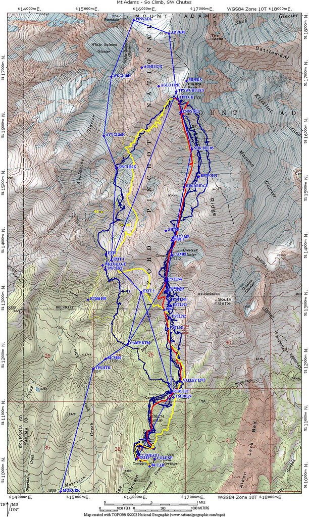
Cross that ridge much lower and the bush whacking and steeper terrain crossing that ridge adds to travel difficulties.
Any more I'll either exit the chutes high left like that or else continue straight down to the RTM trail and skin or walk out (depending on snow cover). Exit attempts in between those two options (such as the solid blue track) have inevitably resulted in racking up a major excess of torture points.
In that you'll obviously be going before you can drive to Cold Springs you might also note that if your navigation skills are top notch (or you break down and spring for a gps) the direct line from Morrison Creek CG (up the Short Horn Trail until it starts left at about 5500, then right) to the Pack trail ridge saves about a mile of Cold Springs road travel on the climb. Having the ability to navigate that shortcut also allows you to ski back out the Morrison Creek Drainage to the CG from the higher traverse which is a much nicer ski than coming back down the Cold Springs road.
Drop me an email if you would like me to shoot you a higher res copy of the map.
We'll watch for your report. Have a good trip.
Reply to this TR
Please login first: