May 6-10, Sierra Nevada, Paiute Pass to Rock Creek
5/15/09
US elsewhere
1725
6
With spring in full gear and the weather stabilizing down south, it was time to head to California for another extended spring ski trip in the Sierra Nevada. Tyler, Lindsey and I met up with our friends Mark and Lucy (mchin and lucy of t-tips fame) from the Bay Area to do one of the classic crest tours from North Lake up to Rock Creek.
Some additional photos beyond those shown below:
http://picasaweb.google.com/iluka1968/PaiutePassToRockCreek509#
Starting off, we had the benefits of some good beta on road and snow conditions on the east side of the range from Zap's recent trip reports. Things were looking much more promising than last year's bony snow pack which left us walking with skis on the packs for significant stretches of our tour from Saddlebag Lake to Twin Lakes. After a quick flight to Reno, a short tour and nice turns on some slopes around Virginia Lakes while waiting for Mark and Lucy to arrive and the obligatory pre-tour dinner at the Whoa Nellie Deli, we were on our way on what turned out to be another great tour in awesome weather over great terrain with buckets of corn snow. This tour was particularly appealing as, with the exception of the very beginning and the very end, it was spent almost entirely above treeline at very high elevations (largely above 11,000 feet) with great views in all directions.
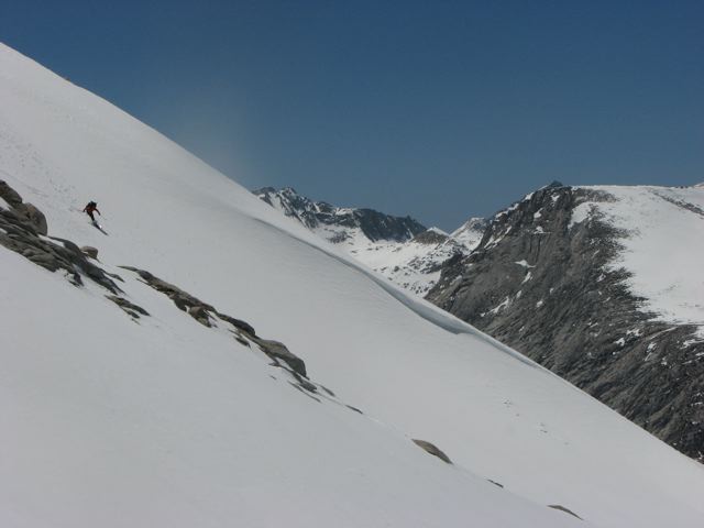
Day 1 involved heading from North Lake, over Paiute Pass into Humphrey's Basin. Rt. 168 from Bishop was open all the way to the turn off to North Lake but the gate was locked there so we walked from there up to the trailhead. The skis stayed on the packs until about 10,500 feet below Loch Leven. From there we would have them on until the last 1-2 miles of the trip.... a big change from the previous year for us. The skinning up to Paiute Pass was easy over gently rising slopes and from there we proceeded to our first night's camp in Humphreys Basin with great views of the Glacier Divide in the distance. This was the first of several nights spent under a full or nearly full moon which made for spectacular night time viewing.
Day 2 brought more sunshine and we headed out of the basin towards Desolation Lake and Steelhead Pass. Waiting for a few of our party to gain the pass afforded an opportunity for the first of many corn snow runs of the trip. From the pass, we dropped down towards Steelhead Lake above French Canyon. In the summer, the pass is steep and composed largely of very large, unpleasant talus, but with the current snow pack, the descent was easily done by staying to skiers left and avoiding the steep drop off at the base of the slope. Once down at the lake, we continued toward Pine Creek Pass and from there climbed up to the Royce Lakes basin. We set up camp above the lakes, right below Merriman and Royce Peaks with great views of French Canyon and the Glacier Divide to the south.
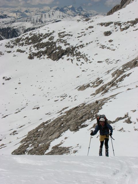
Day 3 started with an easy skin past Royce and Feather Peaks toward the third Royce Lake where we dropped over the saddle at 11,750 feet and into Granite Park. It was only about 10:30 in the morning, but the east facing slope heading down had already corned up perfectly, making for great turns even with the heavy packs. After getting down to about 11,100 feet, we hung a left turn and started skinning up through Granite Park to Italy Pass. Had we had the time, this would have been a great place for a base camp as the upper part of Granite Park is loaded with great bowls and couloirs facing in all directions. The skin up the pass was long but on a steady grade. From there, we dropped 1,500 feet on nice corn snow first to Jumble lake and then around to Lake Italy where we set up our third night's camp.
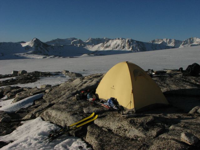
Day 4 was devoted solely to getting over the shoulder of Bear Creek Spire (Cox Col) and down into the Rock Creek drainage. We opted to get a late start that morning to allow the steeper west and northwest facing slopes on the ascent to soften up adequately as the sun hit that spot pretty late compared to other aspects. This made for a straightforward ascent but for a not great descent off the col as the east and north east facing slopes on the other side were well overcooked by the time we started down and in some areas had actually started to crust over as the sun made its way west and hit the slope at a very oblique angle. (A group that preceded us through the area by a day or two took a different tact, opting to camp up high in a basin about 600-800 feet below the col. This option leaves a short morning ascent and opportunities to ski corn earlier in the day on the descent to Dade Lake). As you ascend towards the shoulder of Bear Creek spire from the west, the col appears to be at the lowest portion of the saddle but the descent route is actually located about 100 m northwest on the ridge towards Mt. Dade and another 50-100 feet higher than the saddle itself. From the col, we descended about 1,500 feet to Dade Lake where we set up our last camp. The top portion was not the best snow but lower down we found better conditions and easier turning.
Day 5 dawned with yet more sun and warm temps. We took some early morning runs on the slopes below the ridge between Bear Creek spire and Mt. Dade, finding great corn snow by 9:30AM. After that little jaunt, we loaded up our gear and headed out for the car. We skied out from the lake over the broad plateaut to the north of the lake and followed the ridge coming off the north side of that hump all the way down to Long Lake where we picked up skiers tracks on the summer trail that we followed all the way out to Mosquito Flats. Discontinuous snow started around Box Lake but you could put skis on for long stretchs to within about one-quarter mile of the flats from where you had to walk to the trailhead and then down to the parking area at the locked gate 1.5-2 miles below the trailhead.
As with all good trips in the area... we finished with the obligatory stop at the Mobil Station and some refueling at the Whoa Nellie Deli. I highly recommend the pork chops.
Some additional photos beyond those shown below:
http://picasaweb.google.com/iluka1968/PaiutePassToRockCreek509#
Starting off, we had the benefits of some good beta on road and snow conditions on the east side of the range from Zap's recent trip reports. Things were looking much more promising than last year's bony snow pack which left us walking with skis on the packs for significant stretches of our tour from Saddlebag Lake to Twin Lakes. After a quick flight to Reno, a short tour and nice turns on some slopes around Virginia Lakes while waiting for Mark and Lucy to arrive and the obligatory pre-tour dinner at the Whoa Nellie Deli, we were on our way on what turned out to be another great tour in awesome weather over great terrain with buckets of corn snow. This tour was particularly appealing as, with the exception of the very beginning and the very end, it was spent almost entirely above treeline at very high elevations (largely above 11,000 feet) with great views in all directions.
Day 1 involved heading from North Lake, over Paiute Pass into Humphrey's Basin. Rt. 168 from Bishop was open all the way to the turn off to North Lake but the gate was locked there so we walked from there up to the trailhead. The skis stayed on the packs until about 10,500 feet below Loch Leven. From there we would have them on until the last 1-2 miles of the trip.... a big change from the previous year for us. The skinning up to Paiute Pass was easy over gently rising slopes and from there we proceeded to our first night's camp in Humphreys Basin with great views of the Glacier Divide in the distance. This was the first of several nights spent under a full or nearly full moon which made for spectacular night time viewing.
Day 2 brought more sunshine and we headed out of the basin towards Desolation Lake and Steelhead Pass. Waiting for a few of our party to gain the pass afforded an opportunity for the first of many corn snow runs of the trip. From the pass, we dropped down towards Steelhead Lake above French Canyon. In the summer, the pass is steep and composed largely of very large, unpleasant talus, but with the current snow pack, the descent was easily done by staying to skiers left and avoiding the steep drop off at the base of the slope. Once down at the lake, we continued toward Pine Creek Pass and from there climbed up to the Royce Lakes basin. We set up camp above the lakes, right below Merriman and Royce Peaks with great views of French Canyon and the Glacier Divide to the south.
Day 3 started with an easy skin past Royce and Feather Peaks toward the third Royce Lake where we dropped over the saddle at 11,750 feet and into Granite Park. It was only about 10:30 in the morning, but the east facing slope heading down had already corned up perfectly, making for great turns even with the heavy packs. After getting down to about 11,100 feet, we hung a left turn and started skinning up through Granite Park to Italy Pass. Had we had the time, this would have been a great place for a base camp as the upper part of Granite Park is loaded with great bowls and couloirs facing in all directions. The skin up the pass was long but on a steady grade. From there, we dropped 1,500 feet on nice corn snow first to Jumble lake and then around to Lake Italy where we set up our third night's camp.
Day 4 was devoted solely to getting over the shoulder of Bear Creek Spire (Cox Col) and down into the Rock Creek drainage. We opted to get a late start that morning to allow the steeper west and northwest facing slopes on the ascent to soften up adequately as the sun hit that spot pretty late compared to other aspects. This made for a straightforward ascent but for a not great descent off the col as the east and north east facing slopes on the other side were well overcooked by the time we started down and in some areas had actually started to crust over as the sun made its way west and hit the slope at a very oblique angle. (A group that preceded us through the area by a day or two took a different tact, opting to camp up high in a basin about 600-800 feet below the col. This option leaves a short morning ascent and opportunities to ski corn earlier in the day on the descent to Dade Lake). As you ascend towards the shoulder of Bear Creek spire from the west, the col appears to be at the lowest portion of the saddle but the descent route is actually located about 100 m northwest on the ridge towards Mt. Dade and another 50-100 feet higher than the saddle itself. From the col, we descended about 1,500 feet to Dade Lake where we set up our last camp. The top portion was not the best snow but lower down we found better conditions and easier turning.
Day 5 dawned with yet more sun and warm temps. We took some early morning runs on the slopes below the ridge between Bear Creek spire and Mt. Dade, finding great corn snow by 9:30AM. After that little jaunt, we loaded up our gear and headed out for the car. We skied out from the lake over the broad plateaut to the north of the lake and followed the ridge coming off the north side of that hump all the way down to Long Lake where we picked up skiers tracks on the summer trail that we followed all the way out to Mosquito Flats. Discontinuous snow started around Box Lake but you could put skis on for long stretchs to within about one-quarter mile of the flats from where you had to walk to the trailhead and then down to the parking area at the locked gate 1.5-2 miles below the trailhead.
As with all good trips in the area... we finished with the obligatory stop at the Mobil Station and some refueling at the Whoa Nellie Deli. I highly recommend the pork chops.
Great trip. Your timing was perfect - right after the big wind/snow event further north.
So much granite, so little time! Great photographs and well written report on such a nice area Andy- thanks for sharing! Fond memories of the sun, dry air, wild and alpine places, and of course the Mobile station (that place is such a successful concept!).
Great TR and pics. That was us who was in front of you - we started on Tuesday, May 5. Fabulous ski tour. Thanks for sharing. JM
We followed your tracks most of the way... thanks for showing the way.
That camp you guys had high up on the route to Cox Col looked like a sweet spot. Must have been a great sunset from up there.
That camp you guys had high up on the route to Cox Col looked like a sweet spot. Must have been a great sunset from up there.
You are right - that was our favorite camp of the trip. Which route did you take off of Bear Creek? That was pretty intense (for us).
author=jmanotti link=topic=13309.msg55430#msg55430 date=1242142864]
You are right - that was our favorite camp of the trip. Which route did you take off of Bear Creek? That was pretty intense (for us).
We descended the same way you guys did up top... traversing out onto the slope from the ridge. After the first hundred or so feet, we headed to the right as you did, except Tyler who took a steeper line down. I don't think anyone would have described our skiing off the very top as "pretty" as the snow was not in good shape at all by that time of the day. "Survival skiing" might have been more apt.
Reply to this TR
Please login first: