May 3, 2009, Cashmere Mtn, Indecision Tour
5/3/09
WA Cascades East Slopes Central
1796
6
John Plotz left a terse TR yesterday about a ski traverse over the West Peak of Cashmere Mountain. For the 'just-the-facts crowd, its enough but as a writer it's hard to halt the diarrhea of the pen once I start. Which is what happened when I wrote about this for the website I manage where I collect and concentrate info about Central Washington adventure sports. For those of you who like crackers along with your cheese, Im augmenting Johns TR.
+++++
Saturday evening and Im thinking about bailing. Im not enthralled with tomorrows forecast (high freezing level and a good chance of rain) and beg to differ with the bumper sticker stating, A bad day in the mountains is better than a good day of work. Personally I prefer drinking coffee and writing something thoughtful to wandering around in a whiteout getting soaked.
Even though Im thinking about bailing on this tour traversing the West Peak of Cashmere Mountain, I probably wont. At this late date (10 hours before departure), it would be bad form to bail on my partners. And how many times have I headed out into iffy weather and landed on the feet of a great day?
The phone rings. Its Tom. John and I are thinking that rock climbing at Vantage would be a better use of the day than wandering around in a wet whiteout. You OK with that?
Definitely. Relief floods through me as I throw the skis out of the car and put together a climbing pack.
At 6:00 a.m. the light streaming through the curtains looks brighter than it should. I peek out and curse the bad luck of brilliant Wenatchee sunshine. I stumble outside¦its clear in every direction and the air is remarkably cold. Its perfect alpine weather¦ which were going to waste at the Vantage Rock Mall amongst a flock of flexing peacocks.
The phone rings. Tom is feeling the same despair. You willing to go back to the original plan?
Definitely.
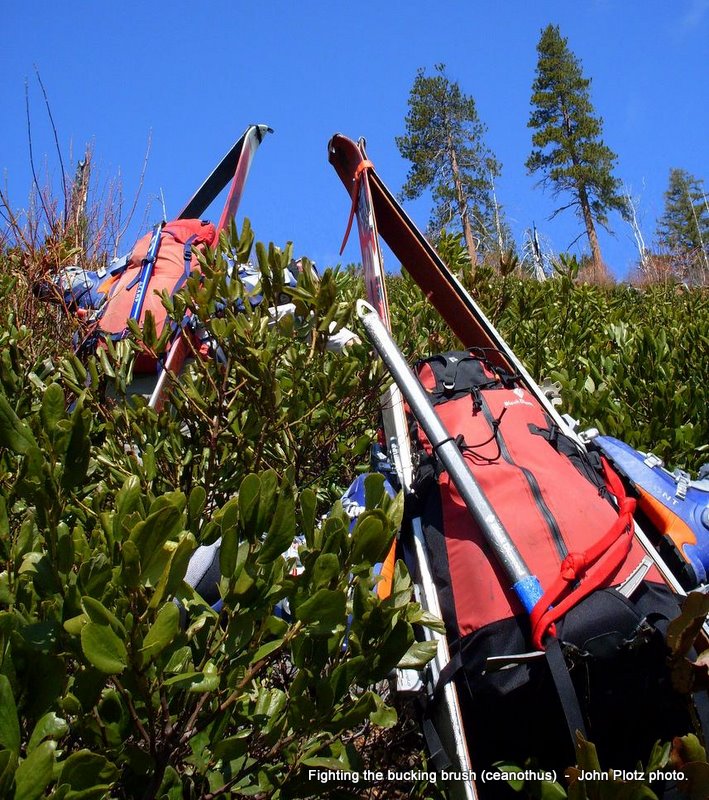
By 9 a.m. weve reassemble our ski kits, shuttled cars for our traverse, and are a half-mile up the Eightmile Lake Trail. Were several hours behind our original schedule so we opt to gain time by branching off the flat Eightmile Lake Trail in favor of the Goat Highway a steep, cross-country climb to higher ground that can be fast or slow depending on whether or not you find the goat trails slicing through all the bucking brush. Were lucky and, with only the occasional thrash, climb quickly to 5,500 feet where skis move from shoulders to feet.
We tour through old burns with silver whiskers poking out of the slopes white skin and climb above timberline. Something about the skys cobalt hue, the clouds exaggerated loft, and the airs clarity is unreal. The jagged skylines of the Enchantments and Stuart Range are reminiscent of the phony backdrops from old cigarette ads that tried to make the moronically contradictory connection between destroying your lungs and taking a step on the wild side.
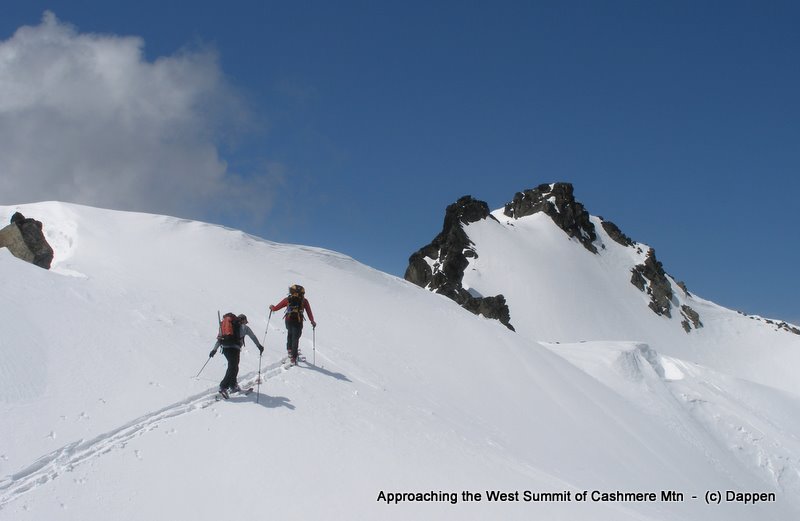
Were on the summit by early afternoon surrounded by feel-good scenery and sunshine. We take a short break; then we traverse onto the slopes forming the headwaters of Doctor Creek. Rather than the smooth south-side corn snows we climbed, the snow on these northern aspects proves indecisive. We find pockets of soft powder, pockets of wind-affected powder, pockets of hardpack powder. None of it skis badly; bits of it ski brilliantly.
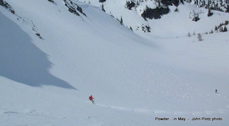
We drop through heli-skiing terrain and, at the 6,100-foot level, the snow abruptly changes from some member of the powder family to a rootstock of corn. The dropping continues and the corn deepens, turns to slush, and eventually morphs into a bottomless slurry. At 3,600 feet, the indecisive snow calls its quits and disappears.
As we strap boards to packs and prepare to walk several miles of dirt road down to the Icicle River, we wrestle with the lessons of the day. Perhaps we just should have stuck with Plan A all the way and kept the faith. Perhaps when we concocted Plan B we should have still kept Plan A in motion, gotten up early to assess the weather, and picked between the two options at that time. Perhaps we played it perfectly and Fate was guiding us all along we did, after all, have a spectacular day and were not punished for our late start.
Every option has merits and counterarguments -- like everything today, we just cant decide.
+++++
More details and a topo map of this tour.
+++++
Saturday evening and Im thinking about bailing. Im not enthralled with tomorrows forecast (high freezing level and a good chance of rain) and beg to differ with the bumper sticker stating, A bad day in the mountains is better than a good day of work. Personally I prefer drinking coffee and writing something thoughtful to wandering around in a whiteout getting soaked.
Even though Im thinking about bailing on this tour traversing the West Peak of Cashmere Mountain, I probably wont. At this late date (10 hours before departure), it would be bad form to bail on my partners. And how many times have I headed out into iffy weather and landed on the feet of a great day?
The phone rings. Its Tom. John and I are thinking that rock climbing at Vantage would be a better use of the day than wandering around in a wet whiteout. You OK with that?
Definitely. Relief floods through me as I throw the skis out of the car and put together a climbing pack.
At 6:00 a.m. the light streaming through the curtains looks brighter than it should. I peek out and curse the bad luck of brilliant Wenatchee sunshine. I stumble outside¦its clear in every direction and the air is remarkably cold. Its perfect alpine weather¦ which were going to waste at the Vantage Rock Mall amongst a flock of flexing peacocks.
The phone rings. Tom is feeling the same despair. You willing to go back to the original plan?
Definitely.
By 9 a.m. weve reassemble our ski kits, shuttled cars for our traverse, and are a half-mile up the Eightmile Lake Trail. Were several hours behind our original schedule so we opt to gain time by branching off the flat Eightmile Lake Trail in favor of the Goat Highway a steep, cross-country climb to higher ground that can be fast or slow depending on whether or not you find the goat trails slicing through all the bucking brush. Were lucky and, with only the occasional thrash, climb quickly to 5,500 feet where skis move from shoulders to feet.
We tour through old burns with silver whiskers poking out of the slopes white skin and climb above timberline. Something about the skys cobalt hue, the clouds exaggerated loft, and the airs clarity is unreal. The jagged skylines of the Enchantments and Stuart Range are reminiscent of the phony backdrops from old cigarette ads that tried to make the moronically contradictory connection between destroying your lungs and taking a step on the wild side.
Were on the summit by early afternoon surrounded by feel-good scenery and sunshine. We take a short break; then we traverse onto the slopes forming the headwaters of Doctor Creek. Rather than the smooth south-side corn snows we climbed, the snow on these northern aspects proves indecisive. We find pockets of soft powder, pockets of wind-affected powder, pockets of hardpack powder. None of it skis badly; bits of it ski brilliantly.
We drop through heli-skiing terrain and, at the 6,100-foot level, the snow abruptly changes from some member of the powder family to a rootstock of corn. The dropping continues and the corn deepens, turns to slush, and eventually morphs into a bottomless slurry. At 3,600 feet, the indecisive snow calls its quits and disappears.
As we strap boards to packs and prepare to walk several miles of dirt road down to the Icicle River, we wrestle with the lessons of the day. Perhaps we just should have stuck with Plan A all the way and kept the faith. Perhaps when we concocted Plan B we should have still kept Plan A in motion, gotten up early to assess the weather, and picked between the two options at that time. Perhaps we played it perfectly and Fate was guiding us all along we did, after all, have a spectacular day and were not punished for our late start.
Every option has merits and counterarguments -- like everything today, we just cant decide.
+++++
More details and a topo map of this tour.
Andy, another wonderfully crafted report!
Looked like a great adventure and the clear weather also caught me by surprise.
In this day of high tech weather reporting, Mother Nature's Spring closet is always full of surprises and can beat the best technology has to offer!
I always wondered, yet never lifted a finger in research, what that brush is that you whacked through. Hmmm... Ceanothus or some variety of the source.
That brush, in the fall emits a fragrance that smells like Big Red chewing gum. It is quite pleasant hiking when Autumn's warm updrafts catch the aroma.
Great TR -- hard to make a bad choice when you've got sunshine, but this:
Vantage Rock Mall amongst a flock of flexing peacocks
is classic and a strong argument for the ski tour :)
Vantage Rock Mall amongst a flock of flexing peacocks
is classic and a strong argument for the ski tour :)
Ceanothus does have a strong smell, though I never associated it with Big Red chewing gum...explains why deer are partial to it (Buckbrush is the common name).
Regarding poking fun at the rock scene, I also poke fun at myself ... I'm as much a part of it as the next hardware-jangling cow. I agree, Marcus, ski touring is the more soulful pursuit.
Regarding poking fun at the rock scene, I also poke fun at myself ... I'm as much a part of it as the next hardware-jangling cow. I agree, Marcus, ski touring is the more soulful pursuit.
Heh -- I was going to add that I've been one of those flexing peacocks in the past, and will probably be again. I love dancing around on rock, but ski touring grabs me in a different place.
Thanks for this and the more detailed TR on your other website. Would you hazard a guess as to conditions at Colchuck & Dragon this Saturday? We've been having fast moving weather in Seattle--but yours is a different country. N
Niko, I find this link to the week-long graphical depiction of the different telemetry sites around the state particularly useful:
http://slum.dyndns.org:8090/plots/plots.html
Check out the 24-hour snowfalls and total snow depth of Stevens Pass (only the Highway site is working now) and Mission Ridge. Colchuck Dragontail usually falls about half way inbetween.
Incidentally in my browser when I click on one of the telemetry sites the graphs often load in below the visible screen view and I need to scroll down to them.
Reply to this TR
Please login first: