4/25-26: Colchuck, Dragontail, and Canon solo tour
4/15/09
WA Cascades East Slopes Central
4928
8
So came Friday. I hadn't put in the effort to find/join any friends excursions or meet anyone new for some skiing but I decided that I wanted to do something solo anyway: go up to the Enchantments. I have been wanting to go up there when there's snow on the ground anyway. And what better way to go up there with a goal: as many of the nearby scramble-peaks as possible in two days. Because I was going solo I wanted to feel more secure so I bought a GPS. Yes, it is an aid, but whatever.
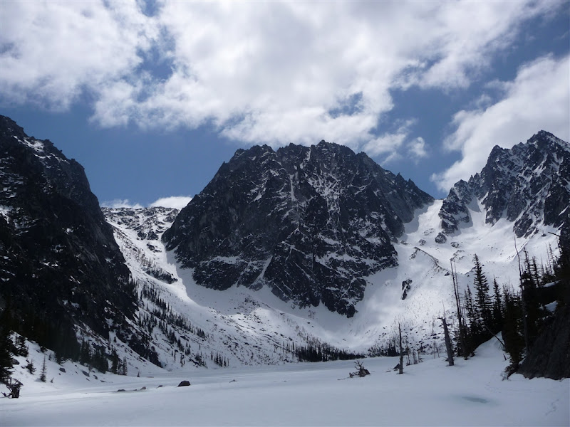
Got to about one mile before the Colchuck lake TH at 8:30. After losing the trail a few times, enjoyed a bit more of ski-cramponing practice I made it up to Colchuck lake by 10:30. En route I also realized that I needed to have my boots resoled: I couldn't do any toeing on rock since the rubber has been eaten away by way too much drytrail boot-packing. I crossed the lake which seemed safest to cross, though I was hesitant because I was solo and not familiar with lake-crossing do's and don'ts.
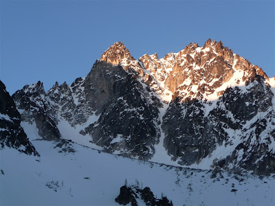
I dropped my overnight gear, rested not too long and then started up Colchuck Glacier. By this time the clouds were becoming more prevalent, the temperature dropped and the wind picked up a bit making the to-be awesome ski-descent a bit less awesome. I had to continually adjust my layering: going from sweating madly, to freezing, which slowed me down a bit. With I got my way to the top of the col by 2:30 and started to head for the summit. My camelbak had been frozen for a while even when tucked into my jacket, and I spontaneously got really cold and slightly nauseous. I decided to open the camelbak and drink from the filling-cap. I drained it. I also used my 'emergency' hand warmers for my tingly fingers. Those did the trick. I walked a bit longer and suddenly one of the crampons I put on my right foot fell off. One of the Grivel aluminum crampons I've enjoyed for many years bent so that the toe and heel piece couldn't stay connected. Damn. At least I was near the top. I felt rejuvenated and got to the top by 3:00. The summit was in and out of the clouds, as were the surrounding peaks .
I enjoyed a number of turns on hard wind-beaten styrofoam mixed with occasional sun softened butter. It was not the best of conditions for the descent ski but it was still effing rad.
I got to the lake, was mad hungry and thirsty, needed to repair my crampons (done with duck tape) so I decided to change my plans slightly. I wouldn't get atop Asgard that night and instead would sleep and get to the Enchantments on Sunday. After enjoying a cozy first night in my new 4-season bivy I started up at 6:20am and got to the top of Asgard by 7:20.
It was gorgeous in the sun. I put on some sunscreen and remembered that I wished I had remembered my spf chapstick...
A bit before 9 I was on Dragontail enjoying the unclouded view. It was time to descend and I was putting on one my skis like I always do: clip the leash, put the to in the pivots and step down and pull up on the leash attachment just in case it doesn't clip. Well when this happend some how when I pulled on the leash it unclipped from my ski which then began to tumble down the mountain. I did what any reasonable person would do and lept down the slope after it grabbed it temporarily and then had to self arrest myself. Fortunately I was able do slow it down and turn it upside down so that it in 10 more feet and didn't go down all the way to Ingall's creek. That would have sucked...
That fiasco was saved. Realizing that I wasn't going as fast as I had wanted I decided that Little Anapurna was not in my cards if I wanted to do my major goal: Canon. I made haste across the basin and up to Prussik pass by 11:00.

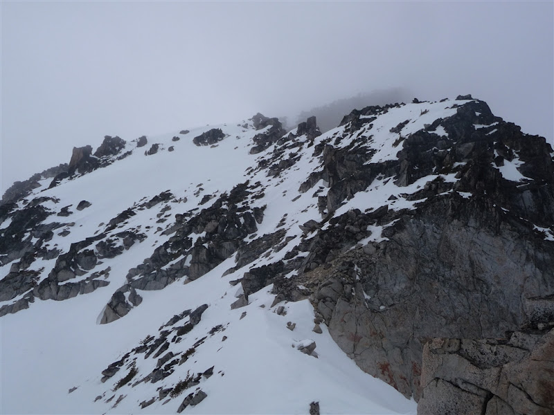
I took my bearings and headed for Canon. As was ascending I had to boot pack because the sun-hit slope was way too sloppy for skinning and I didn't want to be under big swaths of snow doing switch backs. I arrived at what was merely a pseudo summit. Not even a false summit because it was too far away from Canon. Much annoying scrambling ensued: my boots that were unable to purchase any toe-hold and I consequently had to walk on the boulders with my heals or sides. This slowed me down immensely.
I finally summited by 1:00.
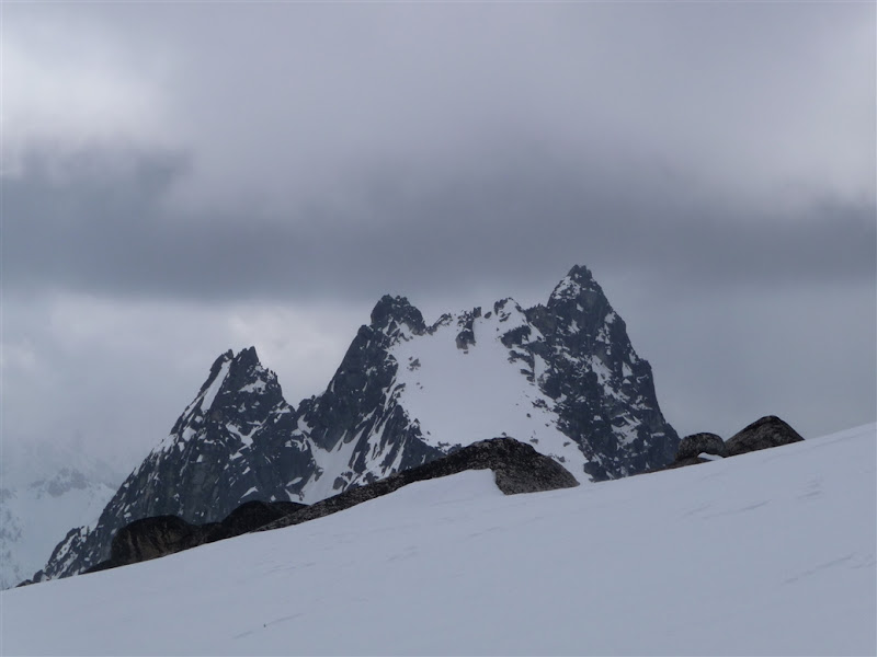
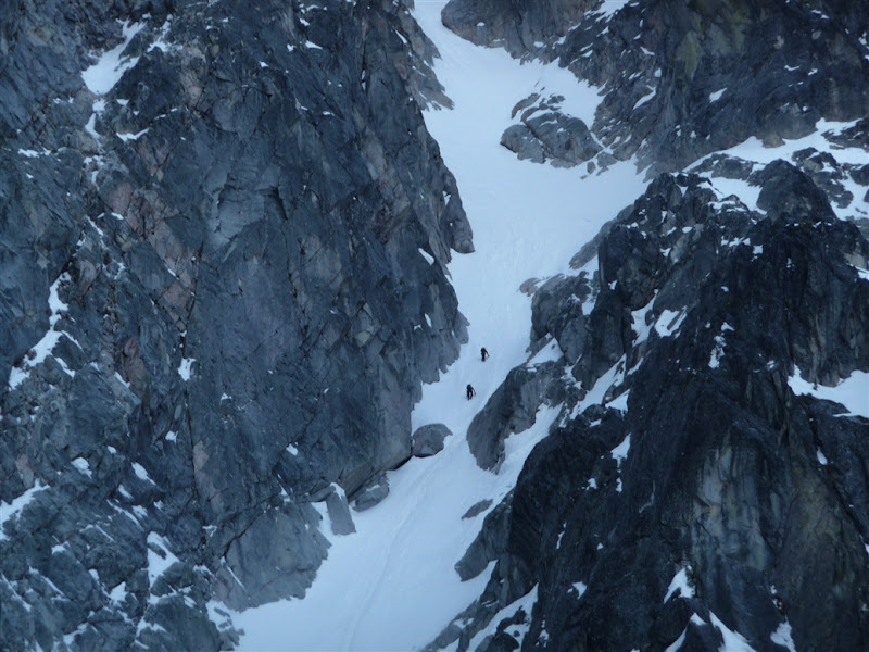
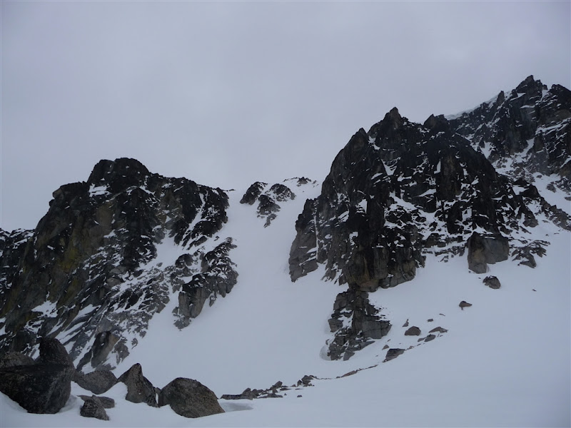
The clouds were looming again and I still had to find my exit couloirs. I followed a few old ski-tracks until they disappeared, likely into a white abyss leading to Coney lake. Scary! I knew that there were several couloirs but I didn't recall which one. I skied down to the last couloir that looked like it could be skiable, walked a bit to get a better vantage to ensure I wouldn't be cliffed-out, and it went all the way down. Sweet. Hence I began a damn wicked descent of some pretty good snow. One place it became hard-styrofoam and I lost balance and had to whippet arrest. During this fall I seemed to break the basket of my whippet. Great. I now had a pathetic ice-axe in addition to my other pole. (left Couloir below is the one I skied down).
My day was not over as I still had to get back. I had originally intended on skiing a Couloir that I saw from the road that was almost immediately north of Coney lake. I boot packed it back up to the ridge that flanks the south side of Mountaineer's creek. I was going to ridge traverse/scramble to this Couloir: I wanted some more good skiing . However the scrambling proved far too annoying, I did not want to 'epic' down going to this essentially unknown Couloir, and because the temperature had dropped and all N-facing aspects that had no sun-heating it would likely be unpleasant snow.
So began my tired descent with a few good turns (and a few painful ones) of the N-NW side down to mountaineer's creek. I did my best to stay in the forest-fire cemetery, which eventually became fallen-tree hell.
So began my class-5 bush-whack descent involving: crawling under logs, squirming over logs, slipping on logs, falling with my ankle almost twisted in a log, plunge-'stepping' in rotten snow up to my thigh, swimming on snow to stay on top of it, bush self belays, walking in a bog. Slightly miserable I finally made it back to the road, and walked down ~1 mile to my car. It was 5:30. Probably a good thing I didn't try that random Couloir or Little Anapurna.
Hungry I stopped by Rudloofs in Leavenworth and got a pizza and coffee. It was a great time.
Stats: 16 miles. ~8.6k vert feet.
Casualties: roof of mouth (sunburned), lips (sunburned), legs (scratched up), pole (broken), crampons (broken), printed map (lost somewhere).
Almost casualty: one my skis, puffy (fell out and tumbled down Colchuck glacier), my ankle .
Gear I'm glad I had: GPS, whippet, MSR reactor (3 L of h20 from snow in like 6 minutes baby).
Unused gear: avy probes (stuffed in my shovel handle, whoops).
Thoughts:
I need to improve the leash-system on my skis.
Make sure you plan your escape so it is not miserable: if you think it might be miserable, then it probably will be. Adjust plans accordingly.
Additional pics at [url]http://picasaweb.google.com/sukiakiumo/Resized?authkey=Gv1sRgCI_HldmYpJjZ4QE&feat=directlink[/url]
Got to about one mile before the Colchuck lake TH at 8:30. After losing the trail a few times, enjoyed a bit more of ski-cramponing practice I made it up to Colchuck lake by 10:30. En route I also realized that I needed to have my boots resoled: I couldn't do any toeing on rock since the rubber has been eaten away by way too much drytrail boot-packing. I crossed the lake which seemed safest to cross, though I was hesitant because I was solo and not familiar with lake-crossing do's and don'ts.
I dropped my overnight gear, rested not too long and then started up Colchuck Glacier. By this time the clouds were becoming more prevalent, the temperature dropped and the wind picked up a bit making the to-be awesome ski-descent a bit less awesome. I had to continually adjust my layering: going from sweating madly, to freezing, which slowed me down a bit. With I got my way to the top of the col by 2:30 and started to head for the summit. My camelbak had been frozen for a while even when tucked into my jacket, and I spontaneously got really cold and slightly nauseous. I decided to open the camelbak and drink from the filling-cap. I drained it. I also used my 'emergency' hand warmers for my tingly fingers. Those did the trick. I walked a bit longer and suddenly one of the crampons I put on my right foot fell off. One of the Grivel aluminum crampons I've enjoyed for many years bent so that the toe and heel piece couldn't stay connected. Damn. At least I was near the top. I felt rejuvenated and got to the top by 3:00. The summit was in and out of the clouds, as were the surrounding peaks .
I enjoyed a number of turns on hard wind-beaten styrofoam mixed with occasional sun softened butter. It was not the best of conditions for the descent ski but it was still effing rad.
I got to the lake, was mad hungry and thirsty, needed to repair my crampons (done with duck tape) so I decided to change my plans slightly. I wouldn't get atop Asgard that night and instead would sleep and get to the Enchantments on Sunday. After enjoying a cozy first night in my new 4-season bivy I started up at 6:20am and got to the top of Asgard by 7:20.
It was gorgeous in the sun. I put on some sunscreen and remembered that I wished I had remembered my spf chapstick...
A bit before 9 I was on Dragontail enjoying the unclouded view. It was time to descend and I was putting on one my skis like I always do: clip the leash, put the to in the pivots and step down and pull up on the leash attachment just in case it doesn't clip. Well when this happend some how when I pulled on the leash it unclipped from my ski which then began to tumble down the mountain. I did what any reasonable person would do and lept down the slope after it grabbed it temporarily and then had to self arrest myself. Fortunately I was able do slow it down and turn it upside down so that it in 10 more feet and didn't go down all the way to Ingall's creek. That would have sucked...
That fiasco was saved. Realizing that I wasn't going as fast as I had wanted I decided that Little Anapurna was not in my cards if I wanted to do my major goal: Canon. I made haste across the basin and up to Prussik pass by 11:00.
I took my bearings and headed for Canon. As was ascending I had to boot pack because the sun-hit slope was way too sloppy for skinning and I didn't want to be under big swaths of snow doing switch backs. I arrived at what was merely a pseudo summit. Not even a false summit because it was too far away from Canon. Much annoying scrambling ensued: my boots that were unable to purchase any toe-hold and I consequently had to walk on the boulders with my heals or sides. This slowed me down immensely.
I finally summited by 1:00.
The clouds were looming again and I still had to find my exit couloirs. I followed a few old ski-tracks until they disappeared, likely into a white abyss leading to Coney lake. Scary! I knew that there were several couloirs but I didn't recall which one. I skied down to the last couloir that looked like it could be skiable, walked a bit to get a better vantage to ensure I wouldn't be cliffed-out, and it went all the way down. Sweet. Hence I began a damn wicked descent of some pretty good snow. One place it became hard-styrofoam and I lost balance and had to whippet arrest. During this fall I seemed to break the basket of my whippet. Great. I now had a pathetic ice-axe in addition to my other pole. (left Couloir below is the one I skied down).
My day was not over as I still had to get back. I had originally intended on skiing a Couloir that I saw from the road that was almost immediately north of Coney lake. I boot packed it back up to the ridge that flanks the south side of Mountaineer's creek. I was going to ridge traverse/scramble to this Couloir: I wanted some more good skiing . However the scrambling proved far too annoying, I did not want to 'epic' down going to this essentially unknown Couloir, and because the temperature had dropped and all N-facing aspects that had no sun-heating it would likely be unpleasant snow.
So began my tired descent with a few good turns (and a few painful ones) of the N-NW side down to mountaineer's creek. I did my best to stay in the forest-fire cemetery, which eventually became fallen-tree hell.
So began my class-5 bush-whack descent involving: crawling under logs, squirming over logs, slipping on logs, falling with my ankle almost twisted in a log, plunge-'stepping' in rotten snow up to my thigh, swimming on snow to stay on top of it, bush self belays, walking in a bog. Slightly miserable I finally made it back to the road, and walked down ~1 mile to my car. It was 5:30. Probably a good thing I didn't try that random Couloir or Little Anapurna.
Hungry I stopped by Rudloofs in Leavenworth and got a pizza and coffee. It was a great time.
Stats: 16 miles. ~8.6k vert feet.
Casualties: roof of mouth (sunburned), lips (sunburned), legs (scratched up), pole (broken), crampons (broken), printed map (lost somewhere).
Almost casualty: one my skis, puffy (fell out and tumbled down Colchuck glacier), my ankle .
Gear I'm glad I had: GPS, whippet, MSR reactor (3 L of h20 from snow in like 6 minutes baby).
Unused gear: avy probes (stuffed in my shovel handle, whoops).
Thoughts:
I need to improve the leash-system on my skis.
Make sure you plan your escape so it is not miserable: if you think it might be miserable, then it probably will be. Adjust plans accordingly.
Additional pics at [url]http://picasaweb.google.com/sukiakiumo/Resized?authkey=Gv1sRgCI_HldmYpJjZ4QE&feat=directlink[/url]
Cool tour! Yeah, I love my Reactor!
What GPS did you buy, with what topo software? I'm in the market for one..
What GPS did you buy, with what topo software? I'm in the market for one..
Damn, what an entertaining TR! ;D
Thanks!
My GPS is a Garmin eTrex Vista Hcx. I really like it, even though the interface isn't necessarily the best. Its light, and has great battery life. For software I got the 'Garmin TOPO U.S. 24K - Northwest Digital Map' which came preloaded on a microSD card but no computer software. I like it, except I can't print maps. I initially didn't have time to properly go through the computer software, but now in retrospect, route planning and map-printing would have been so much nicer with a computer interface.
My GPS is a Garmin eTrex Vista Hcx. I really like it, even though the interface isn't necessarily the best. Its light, and has great battery life. For software I got the 'Garmin TOPO U.S. 24K - Northwest Digital Map' which came preloaded on a microSD card but no computer software. I like it, except I can't print maps. I initially didn't have time to properly go through the computer software, but now in retrospect, route planning and map-printing would have been so much nicer with a computer interface.
thanks for putting together such an awesome tr! love the panorama shots.
way to get out and slay it in less than ideal conditions.
way to get out and slay it in less than ideal conditions.
Cool TR, I've been thinking about that area a lot. Thanks for posting!
This is all the more impressive given the weight of the pack you were carrying, based on your thread in Random Tracks ;) Nice work!
Anyway you could thumbnail some of the photos, to open in a new window? I'd love to see those panos in full size.
Anyway you could thumbnail some of the photos, to open in a new window? I'd love to see those panos in full size.
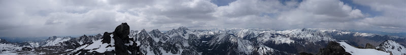
Panorama atop dragontail
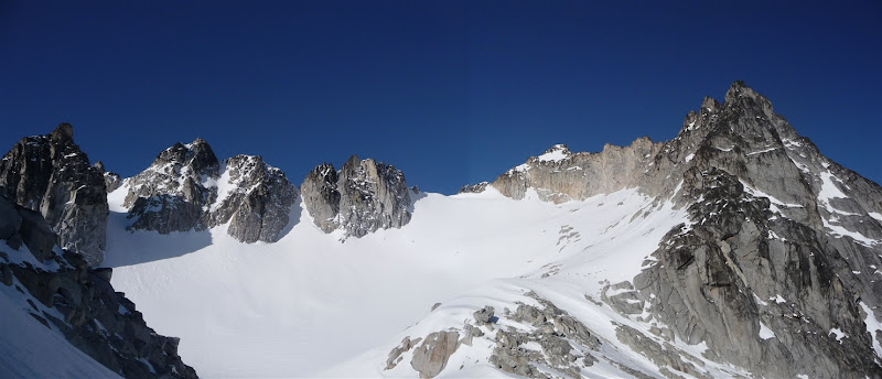
Panorama in Enchantment Basin area
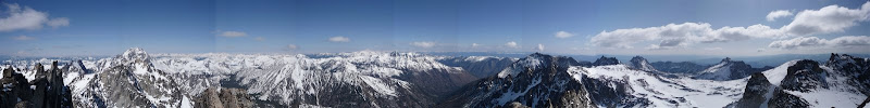
Panorama atop Canon
Sorry, I didn't set up my pictures in an easy way to do thumbs.
Glad you've enjoyed it! And fortunately my pack was slightly lighter than those posts. Maybe ~55lb including skis+boots+skins...
Panorama in Enchantment Basin area
Panorama atop Canon
Sorry, I didn't set up my pictures in an easy way to do thumbs.
Glad you've enjoyed it! And fortunately my pack was slightly lighter than those posts. Maybe ~55lb including skis+boots+skins...
Thanks for the great TR and photos!! I love the panos for sure. ...And about a good lease system on the dynafits, very critical to have! In the photo of you with your skis on your back, it looks like you are using a modified dyna-bondage setup. I tried something like that at one point too, and it didn't work out for me either. :( I will PM the location of a photo of my current leash system to give you some ideas/inspiration.
Reply to this TR
Please login first: