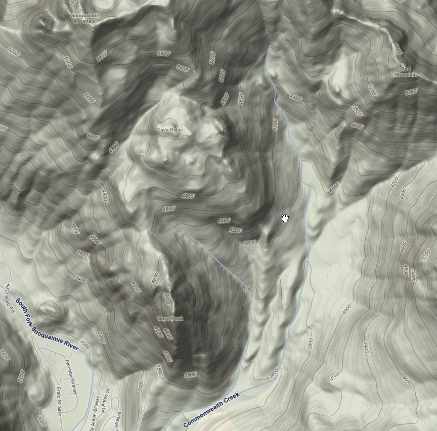
March 30: Cave Ridge
3/15/09
2142
2
Man oh man!!! I need an experienced bc'er to show me were the freaking slot is. Actually I have a fair idea of where it is just not the most efficient way to skin up to it. This time around my brother Dustin and I skinned up waaaaay too far up Commonwealth Basin before attempting Cave Ridge via a particularly exposed col on its NE aspect. All things considered the risk was moderate as a 3' crown evidenced that the slope had largely already slid.
That said it was an experience in all the wrong things that can happen in BC decision making. As my bro and I switched back and forth to safety points on either side a Bright-Circa-1978-Columbia-Coat-Summit-Hog decided to expose himself to our potential avalanche start zone. Where my bro and I went across the most dangereous parts one at a time and carefully this hell-bent bloke chased us up to our last rest point. I was contemplating bailing and would have but I let Darwin Award's Best boot up the riskiest part. I figured hell, I'll let him test it out. He threw a rope down to his more cautious skinning partner whilst by bro and I did our best to stay OUT OF HIS WAY. We opted for several low angle laps on all aspects of Cave Ridge Summit area and exited down closer to Guye Pk and got our good 1500 vertical of nice pow before dodging major hydrological creek chaos on the way out of the basin.
Quote from Bright-Circa-1978-Columbia-Coat-Summit-Hog: "I don't post on TAY because I'm too busy skiing!" Too busy dying might be more like it at his pace, but maybe his Columbia Coat is endowed with superpowers.
Snowpack Analysis at Cave Ridge: Light crust at 10", 5mm brittle crust at 20", on top of major rain/sun crust at 48" or so. Even where the top 3' had slid there was about a foot of heavy multiple layered snow on top of well-bridged by much less dense snow. Where wind loading had occured there were some areas of an upside-down snowpack.
Last lessons: Though the snowshoe track was well blazed and strait as an arrow, it did end exactly where I and hoped it wouldn't. At the bottom of several major slide paths from Red, Ludin, and Snoqualmie. Genius.
Route Description and short audio report: http://www.youtube.com/watch?v=aU1DVxfLGy4
O.K. I'll bite.
Brothers. Hm. I thought you looked simmilar.
After folowing the slowshoe tracks, the yours up through one avy zone and into annother I wanted *outa* there. I figured you were both beat so I raced to the front when you each had a tree to hang on to. At that point it was as much exposure heading up as down. The last 30' was less than optimal. It was comforting to know there would be three people digging for my corps if needed.
I concure w/ you snowpack analysis.
FYI: From the cliffs you skied, there was steep trees just to the S of that (my favorite way off the ridge), then more cliffs, then the avy gullys on the N end of Guy Pk are also skiable.
Bright-Circa-1978-Columbia-Coat-Summit-Hog Jacket (GoreTex) $5 Value Village. I go through one a winter.
sounds like you know your avi terrain when you see it! the question is whether the both of us will actually make better decisions.
Reply to this TR
Please login first: