Jan 9 Wash. Pass region
1/15/09
WA Cascades East Slopes North
2560
2
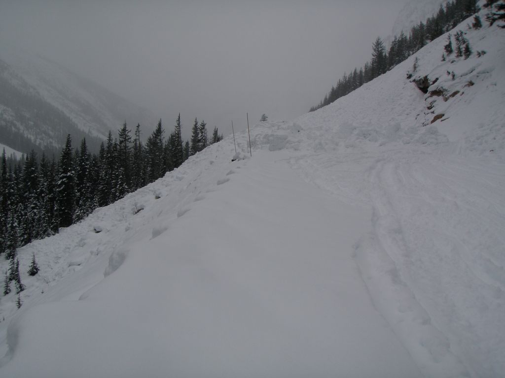
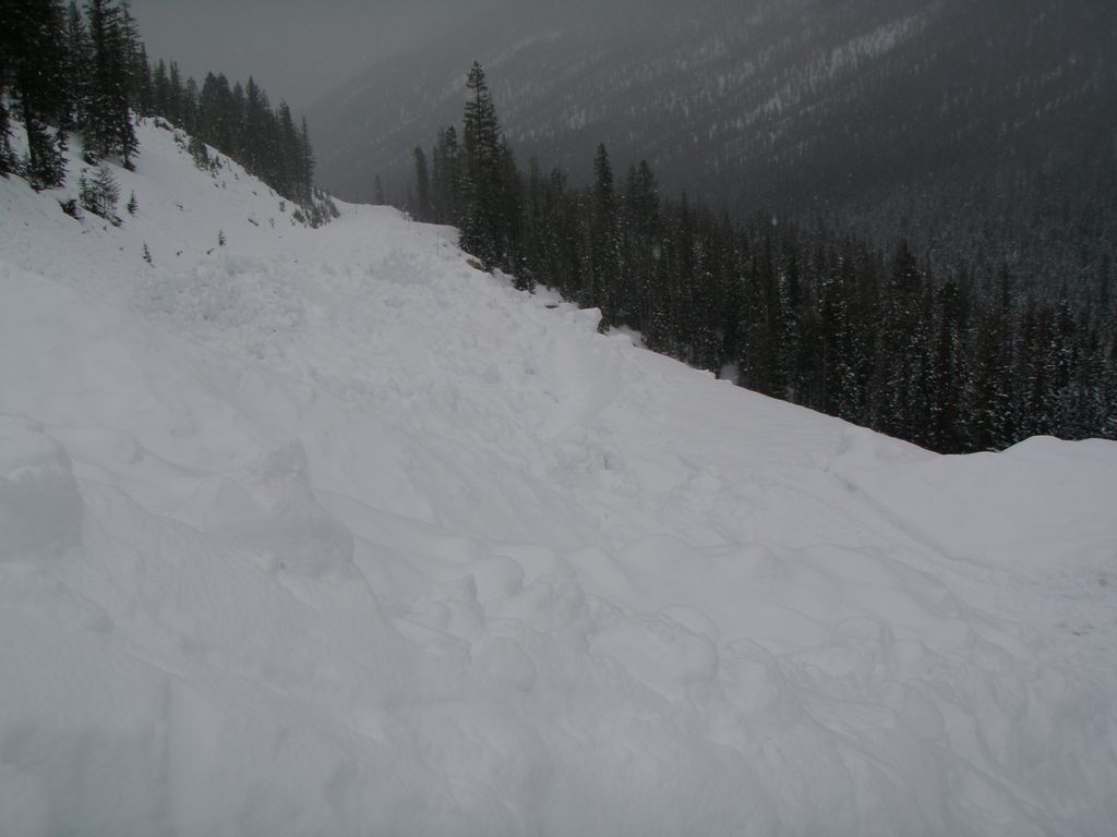
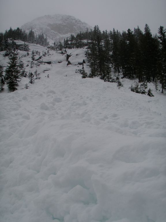
Cuthroat slide paths have 50' deep frozen debris piles on all chutes rendering passage not possible.Climbed N. facing treed run cuthroat T.H. ,500v. rain crust over pow. turning into pow.,thigh to waist deep for remaining 1000v. 4 men , 4 hrs. 1500v. total. trench cutting.Natural releases on all aspects to ground , especially on S. facing ridges and loaded convex slopes below ridge lines.One E. fac. slope slid halfway across the lake.We had to leap frog ski downhill just to get any momentem. You could bury a ski pole past the grip with little resistance. NO headers allowed!
Thanks for the report. I was hoping that someone would go in from the east side, soon after this massive storm ended.
That's because I had noticed during the storm that the Washington Pass telemetry site was the only one which managed to stay almost-all-snow throughout the majority of the storm. Here's the last 3 days of NWAC data, showing the snowdepth increasing from 50" before the storm to maximum of 93" just after the peak of the storm at 7am on Jan 8, with 4.7" of precip up to that time and 5.1" total through right now. Considering the settlement of the pre-existing snowpack caused by the addition of such a huge weight of new snow, the actual storm total is much greater 43", certainly well over 4 ft and probably closer to 5 ft of new snowfall.
Northwest Weather and Avalanche Center
and Washington Department of Transportation
Washington Pass, Washington
Wind sensors unheated and may rime
Equip temp is prec gage temp
Precip gage records periodic condensation
MM/DD Hour Temp Temp RH RH Wind Wind Wind Equip Hour Total Total
PST F F % % Avg Max Dir Temp Prec. Prec. Snow
6630' 5500' 6630' 5500' 6630' 6630' 6630' 5500' 5500' 5500' 5500'
------------------------------------------------------------------------------
1 9 2000 19 20 97 95 0 0 242 43 .01 .15 --
1 9 1900 19 22 97 95 0 0 243 45 .01 .14 79
1 9 1800 20 22 96 97 0 0 243 44 0 .13 80
1 9 1700 20 22 99 96 0 0 242 44 .01 .13 80
1 9 1600 19 22 95 95 0 0 250 45 0 .12 80
1 9 1500 19 24 98 94 0 0 241 46 .01 .12 81
1 9 1400 21 24 98 94 0 0 246 45 0 .11 80
1 9 1300 22 25 97 94 0 0 241 47 .01 .11 81
1 9 1200 23 25 100 94 0 0 236 46 .01 .1 81
1 9 1100 25 22 98 94 0 0 257 45 0 .09 81
1 9 1000 21 20 98 94 0 0 262 41 .01 .09 82
1 9 900 18 19 97 94 0 0 264 40 0 .08 82
1 9 800 17 19 98 94 0 0 247 40 .01 .08 82
1 9 700 15 18 97 95 0 0 234 40 0 .07 83
1 9 600 14 18 96 95 0 0 241 42 .01 .07 83
1 9 500 16 19 96 94 0 0 231 44 0 .06 83
------------------------------------------------------------------------------
1 9 400 16 21 96 95 0 0 227 47 .01 .56 --
1 9 300 17 22 97 94 0 0 237 53 0 .55 82
1 9 200 17 22 97 94 0 0 233 54 .01 .55 --
1 9 100 18 22 98 95 0 0 232 53 .01 .54 85
1 9 0 18 23 97 95 0 0 235 54 .01 .53 --
1 8 2300 18 23 97 95 0 0 240 52 0 .52 85
1 8 2200 19 24 95 95 0 0 233 52 .01 .52 --
1 8 2100 20 24 98 95 0 0 255 53 .01 .51 --
1 8 2000 20 25 99 94 0 0 190 54 0 .5 86
1 8 1900 20 25 99 94 0 0 269 54 .01 .5 85
1 8 1800 21 26 98 96 0 0 250 53 .01 .49 88
1 8 1700 22 26 99 97 0 0 235 49 .03 .48 --
1 8 1600 23 28 100 96 0 0 223 50 .01 .45 88
1 8 1500 24 29 100 95 0 0 230 51 0 .44 87
1 8 1400 26 31 100 93 0 0 239 54 .01 .44 89
1 8 1300 26 31 100 94 0 0 241 53 .01 .43 90
1 8 1200 27 31 100 95 0 0 243 53 .01 .42 --
1 8 1100 26 31 100 95 0 0 252 51 .02 .41 90
1 8 1000 26 31 99 96 0 0 244 54 .05 .39 92
1 8 900 25 30 100 97 0 0 241 58 .03 .34 91
1 8 800 25 30 100 98 0 0 240 59 .02 .31 --
1 8 700 26 30 100 97 0 0 245 58 .1 .29 93
1 8 600 26 31 100 98 0 0 240 57 .13 .19 91
1 8 500 27 31 100 98 8 12 239 54 .06 .06 93
------------------------------------------------------------------------------
1 8 400 28 31 100 99 8 12 236 53 .04 2.99 91
1 8 300 28 32 99 100 11 14 233 52 .13 2.95 --
1 8 200 29 32 100 100 10 13 232 54 .16 2.82 --
1 8 100 29 32 100 99 11 14 232 54 .15 2.66 91
1 8 0 30 32 100 99 11 14 227 54 .16 2.51 --
1 7 2300 30 33 100 99 10 13 228 56 .16 2.35 88
1 7 2200 30 32 100 99 11 14 228 59 .17 2.19 --
1 7 2100 30 32 98 99 13 16 226 56 .17 2.02 81
1 7 2000 29 32 100 100 13 16 227 54 .16 1.85 --
1 7 1900 30 32 100 100 11 13 227 55 .1 1.69 77
1 7 1800 30 32 99 99 9 12 231 55 .1 1.59 76
1 7 1700 30 32 100 99 10 12 233 55 .06 1.49 73
1 7 1600 30 33 100 99 11 13 227 53 .07 1.43 71
1 7 1500 30 33 100 99 13 16 231 54 .12 1.36 --
1 7 1400 29 33 100 99 13 16 231 54 .15 1.24 --
1 7 1300 30 33 100 99 15 18 229 54 .09 1.09 70
1 7 1200 30 33 100 99 16 20 231 54 .13 1 69
1 7 1100 30 32 100 100 17 19 228 56 .13 .87 66
1 7 1000 29 31 100 100 18 21 226 55 .15 .74 67
1 7 900 29 31 100 100 14 17 230 54 .14 .59 64
1 7 800 29 31 100 100 12 17 233 53 .15 .45 64
1 7 700 29 32 100 100 9 11 232 52 .08 .3 61
1 7 600 29 32 100 99 9 11 237 56 .11 .22 --
1 7 500 30 32 100 100 9 13 236 54 .11 .11 --
------------------------------------------------------------------------------
1 7 400 30 33 100 100 10 15 232 52 .11 1.38 --
1 7 300 29 33 100 100 13 18 239 50 .11 1.27 --
1 7 200 29 32 100 100 13 15 241 50 .11 1.16 --
1 7 100 29 32 100 100 13 17 243 50 .11 1.05 --
1 7 0 29 33 100 100 13 18 233 50 .13 .94 --
1 6 2300 30 33 100 100 12 19 235 50 .13 .81 --
1 6 2200 30 33 100 100 12 16 239 50 .13 .68 --
1 6 2100 30 33 100 100 14 18 232 51 .1 .55 --
1 6 2000 30 33 100 100 14 19 235 51 .07 .45 --
1 6 1900 30 33 100 100 14 19 236 51 .06 .38 54
1 6 1800 30 33 100 100 17 23 239 51 .04 .32 --
1 6 1700 29 32 100 100 18 22 235 49 .05 .28 --
1 6 1600 29 32 99 100 16 21 238 50 .03 .23 54
1 6 1500 29 32 100 100 14 18 241 50 .03 .2 --
1 6 1400 29 32 100 100 12 17 235 52 .06 .17 51
1 6 1300 28 31 100 99 12 15 225 54 .07 .11 48
1 6 1200 27 30 100 97 15 19 224 54 .02 .04 --
1 6 1100 26 28 100 98 16 20 228 52 .01 .02 --
1 6 1000 25 27 99 97 11 14 236 50 0 .01 --
1 6 900 23 26 99 98 10 13 237 49 .01 .01 50
1 6 800 22 25 99 97 12 15 236 50 0 0 50
1 6 700 22 24 99 97 13 16 231 48 0 0 --
1 6 600 21 23 99 97 11 16 237 46 0 0 50
1 6 500 21 24 98 97 8 12 248 46 0 0 50
[/tt]
NOTE: all snowdepth values which read "198" have been replaced with "--", those erroneous readings are merely the height of the snowdepth sensor above the ground.
Here are a few photos of the area from today.
Reply to this TR
Please login first: