12/26/08: NO TR!!!!
12/26/08
2305
1
This is the anti TR; please let's spread the word and avoid the devastation of last year...keep the posts flowing at:
http://www.turns-all-year.com/skiing_snowboarding/trip_reports/index.php?topic=11473.new#new
Stay low angle, low elevation, or generally bush-wacked. Don't die.
-Jayme
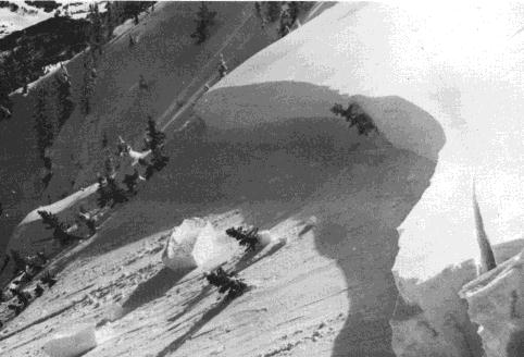
from: http://www.avalanche.org/~moonstone/images/gr000071.jpg
look at all the anchor's! looks like a lee slope right about now!!!
http://www.turns-all-year.com/skiing_snowboarding/trip_reports/index.php?topic=11473.new#new
Stay low angle, low elevation, or generally bush-wacked. Don't die.
-Jayme
from: http://www.avalanche.org/~moonstone/images/gr000071.jpg
look at all the anchor's! looks like a lee slope right about now!!!
http://www.nwac.us/products/SABSEA
SNOWPACK ANALYSIS
Recent moderate snowfall has been received in most areas
during the past few days. For the most part this recent
snow is quite light and fluffy, and intermittent moderate
winds have generally transported this onto lee slopes
where mostly 6-18 inch soft slabs and considerable
avalanche danger exist. These lee slopes are
predominantly northeast to southeast exposures near
higher ridges and west facing slopes near the passes.
Weak layers within our still relatively shallow snowpack
are many and very significant, ranging from buried
surface hoar layers to intermediate or advanced facets to
just really weak low density snow layers. This is perhaps
the weakest snowpack structure that I have observed in
late December for over 20 years, and many field reports
of wading or wallowing in the snow at or near the ground
when one steps off the packed trail seem to corroborate
this assessment. The only positive aspects of the current
snowpack in terms of BC avalanche danger is the
relatively lack of cohesion in the near surface snow and
the still relatively shallow depth that is allowing for
some vegetation and terrain anchoring of this fragile
snowpack below about 4 to 5000 feet.
Overall, our delicate snowpack is primed for a rapid and
dramatic increase in the danger when loaded by heavier
and more normal Cascade snowfalls. Unfortunately, in
order to start putting the daily impact of these
persistent weak layers of facets and surface hoar behind
us, we need substantial loading by heavy dense snow, high
winds and/or rain. Although this kind of weather is
expected to arrive beginning later Friday and continue
for much of Saturday, the current magnitude of frailty
that our snowpack embodies may take many such storms to
build a strengthening bridge over these buried
weaknesses...and even then these flimsy layers may re-
emerge as problems next spring. In short, this weekend
and especially Saturday may be an excellent time to risk
your health away from the mountains by shoveling your
walk, exchanging your gifts at the mall, or trying out
some new high-tech lowland gear.
Reply to this TR
Please login first: