7/9/08, Mt. Rainier, Carbon Glacier to 9k + Emmons to 13.5k
7/9/08
WA Cascades West Slopes South (Mt Rainier)
10088
17
After registering at the ranger station I met Dave Brown at White River campground-(4.2k) around 5:30 on Tuesday the 8th. Our plan was to climb and ski Liberty Ridge in a single push. We quickly ascended the trail, and took Elmo's Pass at ~7600' off the Intergalcier in our traverse to the Winthrop, by this time the sun was a glowing red discus hovering slightly above the western horizon. Some equipment complications slowed us a little, but were quickly resolved with Mgiver type ingenuity. The Winthrop was fairly crevssed at out traverse elevation, and there were many alternating patches of snow and ice. We were surprised by the width, and complicated extent of Curtis Ridge. By the time we reached the 7200' window which descends to the Carbon Glacier, it was dark, and maybe around 11.
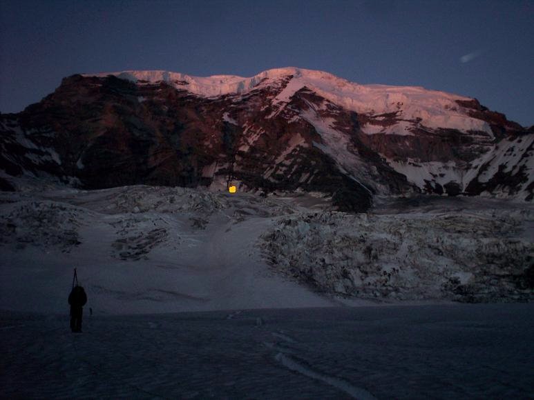
We descended onto the Carbon, fairly confident that we would breeze over the glacier to the route with minimal route finding difficulties, even though neither of us had looked at a guide book, or knew where we were going, and it was dark, this lack of preparation proved to work to our disadvantage... We immediately got our selves into complex crevasses (which could have been avoided with daylight)(Dave was strong and smart enough to bring a rope --- thanks Dave!), we had some interesting negotiations, climbing down into the cracks a little, a leg through here and there, hops here and there, exiting that mess, we were faced with a large crevassed roll, several possible entrances, none looked too appealing, so we took the one which looked the best, finding faint footprints, which were soon lost, or perhaps doubled back in retreat. We worked very hard to find a way over to the start of the route. We deadended over huge gapping crevasses maybe 10 times, I belayed Dave once while he checked out a series of super sketchy bridges. Nothing, disheartend but smart enough to know when to retreat, we did. Sunrise broke beautifully into alpenglow in the indescribable dangerous beauty of Willis Wall, with all its choss and menacing ice cliffs. We could clearly see that Liberty Ridge was definitely not in anywhere close condition to ski. The only bit which looked good was next to the Black Pyramid, which has been described as the ice section in recent TRs.
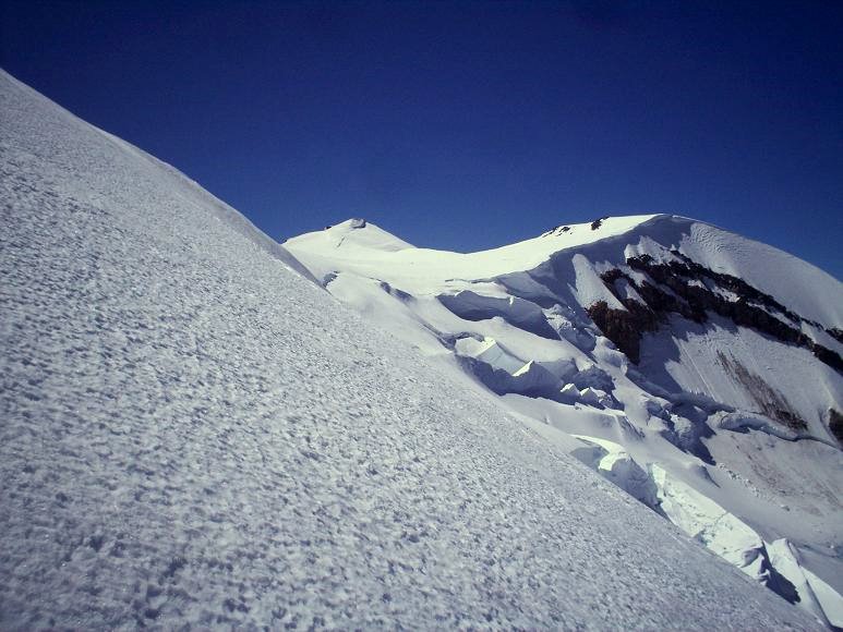
I led us too far up in our traverse back to the Interglacer, we found ourselves at 8k - once we could see past all the choss hills of Curtis Ridge - which was a little annoying, but we did get some descent fall line skiing in down to the Winthrop. By the time we gained Elmo's Pass, overlooking Inter Glacier, it was about 8:30 am. Dave returned to the W.R. campground, I decided to continue up and ski the Emmons Glacier as a consolation in the face of defeat from Liberty.
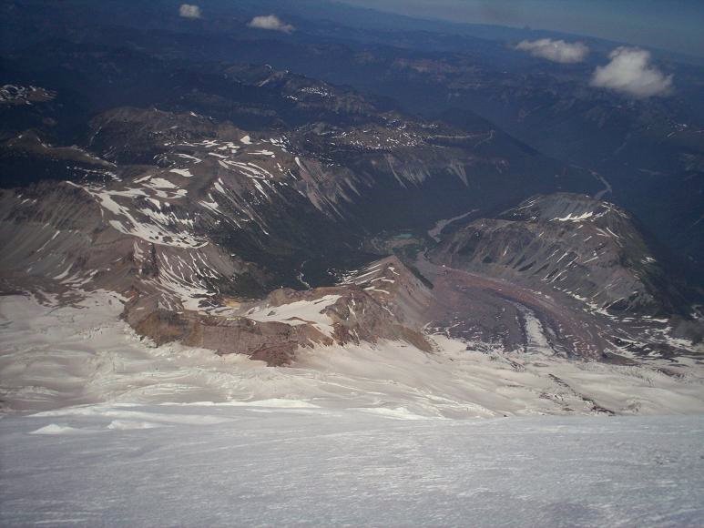
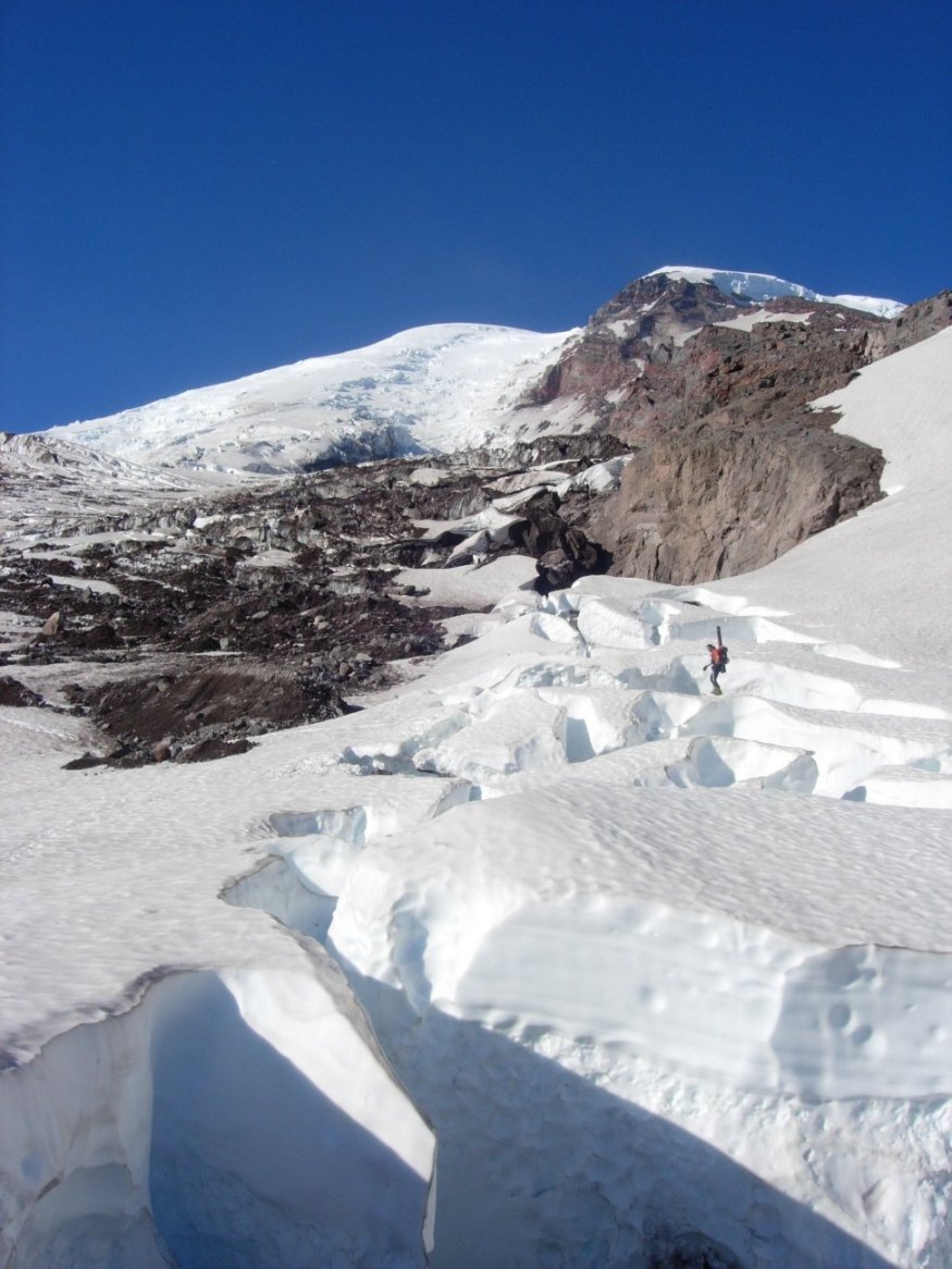
I melted some water and ate, then got on my way. There were many groups doing there thang in the upper Interglacier, Camp Shurman area. I was stoked to ski the Emmons, it's so cool looking, such a big glacier. Route finding was definitely not an issue, I just followed the ridiculous boot pack. All bridges seemed to be in good condition, and crevasses were not a worry. At around 13500' I stopped because of brutal winds, which had changed the snow to frozen suncrusted windboard, I was in no mood to tackle such crap, and I am no purist, so it was not a problem to ski down from there. The upper part was breakable crust, then corn, then slosh. Not a very good ski route in my opinion, since the route twists and turns so much there is relatively little fall line, the climber traffic and the tracks and s#it they leave behind, the crevasse shenanigans, etc...
Good, and less sloshy skiing down the Interglacier. I met some cool people at the campground not far below, hung out with them for a couple hours and made it back to the White River campground about 26 hours after I started. I haven't made it 35 hours without sleep in a long time, kind of cool actually, changes perspective a little.
We descended onto the Carbon, fairly confident that we would breeze over the glacier to the route with minimal route finding difficulties, even though neither of us had looked at a guide book, or knew where we were going, and it was dark, this lack of preparation proved to work to our disadvantage... We immediately got our selves into complex crevasses (which could have been avoided with daylight)(Dave was strong and smart enough to bring a rope --- thanks Dave!), we had some interesting negotiations, climbing down into the cracks a little, a leg through here and there, hops here and there, exiting that mess, we were faced with a large crevassed roll, several possible entrances, none looked too appealing, so we took the one which looked the best, finding faint footprints, which were soon lost, or perhaps doubled back in retreat. We worked very hard to find a way over to the start of the route. We deadended over huge gapping crevasses maybe 10 times, I belayed Dave once while he checked out a series of super sketchy bridges. Nothing, disheartend but smart enough to know when to retreat, we did. Sunrise broke beautifully into alpenglow in the indescribable dangerous beauty of Willis Wall, with all its choss and menacing ice cliffs. We could clearly see that Liberty Ridge was definitely not in anywhere close condition to ski. The only bit which looked good was next to the Black Pyramid, which has been described as the ice section in recent TRs.
I led us too far up in our traverse back to the Interglacer, we found ourselves at 8k - once we could see past all the choss hills of Curtis Ridge - which was a little annoying, but we did get some descent fall line skiing in down to the Winthrop. By the time we gained Elmo's Pass, overlooking Inter Glacier, it was about 8:30 am. Dave returned to the W.R. campground, I decided to continue up and ski the Emmons Glacier as a consolation in the face of defeat from Liberty.
I melted some water and ate, then got on my way. There were many groups doing there thang in the upper Interglacier, Camp Shurman area. I was stoked to ski the Emmons, it's so cool looking, such a big glacier. Route finding was definitely not an issue, I just followed the ridiculous boot pack. All bridges seemed to be in good condition, and crevasses were not a worry. At around 13500' I stopped because of brutal winds, which had changed the snow to frozen suncrusted windboard, I was in no mood to tackle such crap, and I am no purist, so it was not a problem to ski down from there. The upper part was breakable crust, then corn, then slosh. Not a very good ski route in my opinion, since the route twists and turns so much there is relatively little fall line, the climber traffic and the tracks and s#it they leave behind, the crevasse shenanigans, etc...
Good, and less sloshy skiing down the Interglacier. I met some cool people at the campground not far below, hung out with them for a couple hours and made it back to the White River campground about 26 hours after I started. I haven't made it 35 hours without sleep in a long time, kind of cool actually, changes perspective a little.
Sorry Liberty wasn't there for you, Dan. I recommend April-ish.
Somebody finally agrees with me that the Emmons sucks! (Ducks, covers, and runs....)
Somebody finally agrees with me that the Emmons sucks! (Ducks, covers, and runs....)
From the armchair, that shot you have of Lib Ridge makes it seem Out for all modes of travel ... plainly that's a lot of nonsnow below the BP where you have to climb up+left, nearly the whole toe below TR is bare, etc. You keep hearing those stories from people that have to buy a new tent (and new underwear) after rocks make entrance and exit portals in their tents at TR, so more rocks up top can't be a good thing. Be interesting to see how many more reports for Lib Ridge are seen on CC or the blog.
Yeah I've only been on the Emmons route once but it was pretty disappointing how the glacierhikers managed to plunge step every square meter of the route, especially the wide corridor which otherwise seems like a great place to really open it up on skis. At least that's my excuse for the high speed digger...s I took there. I'm not sure why they are so drawn to unstepped snow instead of using the more direct cowpath, but maybe it is jealous punishment. That's the price paid for choosing a convenient dog route. It looks like there should also be a decent line down the Winthrop when its filled in.
You're a purist in my book Dan. Too bad about Liberty, but glad you didn't end up in any holes.
Dan - I was lost in the dark on the glacier with you - a great scene. Thanks for bringing it alive.
This was my foavrite line, though:
this lack of preparation proved to work to our disadvantage...
This was my foavrite line, though:
this lack of preparation proved to work to our disadvantage...
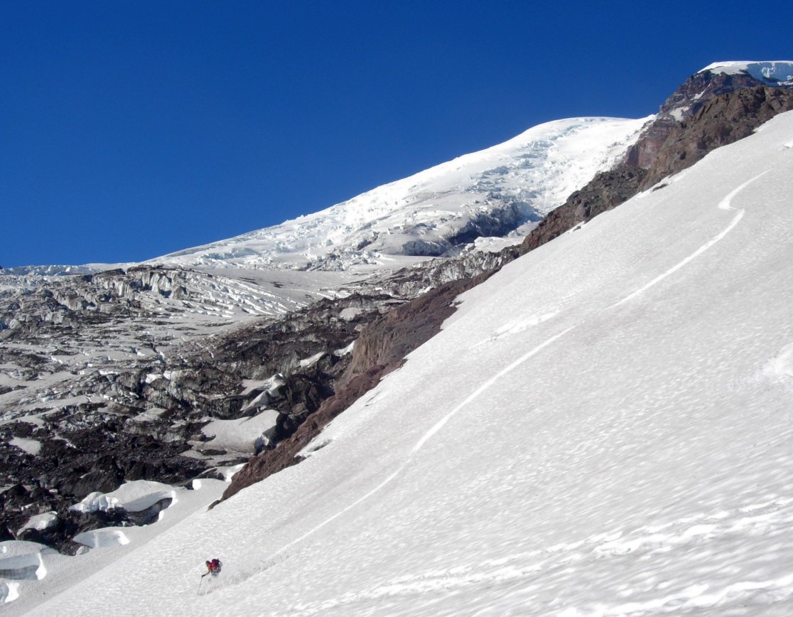
By the way, Dan ended up with around 13,000 feet of vert for the day! Way to get after it. Here are a few photos where I managed to capture the elusive Dan Helmstadter in action.
if the yellow dot was your intended entry point to the route, then I would say you're definitely a purist. ;)
Good spot for serac-watching. ???
Yea, that was the highpoint we achieved in the dark, we tried to go further to the west - to the climbers right of the ridge, but a massive crevasse spanned the entire upper glacier as far as we could tell, we worked our way up to it, constantly looking for a way across, I suppose the real crossing is lower and to the right on the glacier - before the roll, but sunlight revealed that way to be fairly broken too.
We did hear a full on Ice lanch sometime around midnight - sounds like it came from the Liberty Ice cliffs, instead of Willis Wall.
Was just looking at the N.F. Mt. Adams this morning, looks pretty dry.
We did hear a full on Ice lanch sometime around midnight - sounds like it came from the Liberty Ice cliffs, instead of Willis Wall.
Was just looking at the N.F. Mt. Adams this morning, looks pretty dry.
For all my approaches up the Carbon, I was always farther west from lower on the glacier. It gets steeper and has some rolling icefalls just below WW and LR. If possible, my guess is that you may have had an easier time getting over there by traversing across the Carbon Glacier from Curtis Ridge at a lower elevation, which would also be less exposed to bombs from above. Of course, I wasn't there and haven't seen the Carbon this year; that's just my guess.
Dan - the higher hills definitely lacked lubrication from the heavens above this year.
Great pics!
author=ash_j link=topic=10622.msg43141#msg43141 date=1215727896]
I'm not sure why they are so drawn to unstepped snow instead of using the more direct cowpath...
For pretty much the same reasons that skiers rabidly prefer 'fresh tracks'. It's also bad form to posthole down the uphill track.
:)
author=CascadeClimber link=topic=10622.msg43279#msg43279 date=1216062773]The optimal route would look something like this:
For pretty much the same reasons that skiers rabidly prefer 'fresh tracks'. It's also bad form to posthole down the uphill track.
:)
( || ! `.
) || ! `.
( || ! `.
) || ! `.
From left to right, that is ski lane, glissade chute, posthole lane, bootpack. Got it people?!
author=ash_j link=topic=10622.msg43280#msg43280 date=1216063391]
The optimal route would look something like this:
( || ! `.
) || ! `.
( || ! `.
) || ! `.
From left to right, that is ski lane, glissade chute, posthole lane, bootpack. Got it people?!
Ha! Are we going to paint lines next?
author=Marcus link=topic=10622.msg43287#msg43287 date=1216076822]We? Feel free to do whatever you want.
Ha! Are we going to paint lines next?
I forgot the snowboard lane though. It goes more like this:
Reply to this TR
Please login first: