Olympic Bailey Range Ski Traverse June 26-July 1, 2008
7/15/08
WA Olympics
3208
6
2008 Summer Baileys Ski Mountaineering Adventure
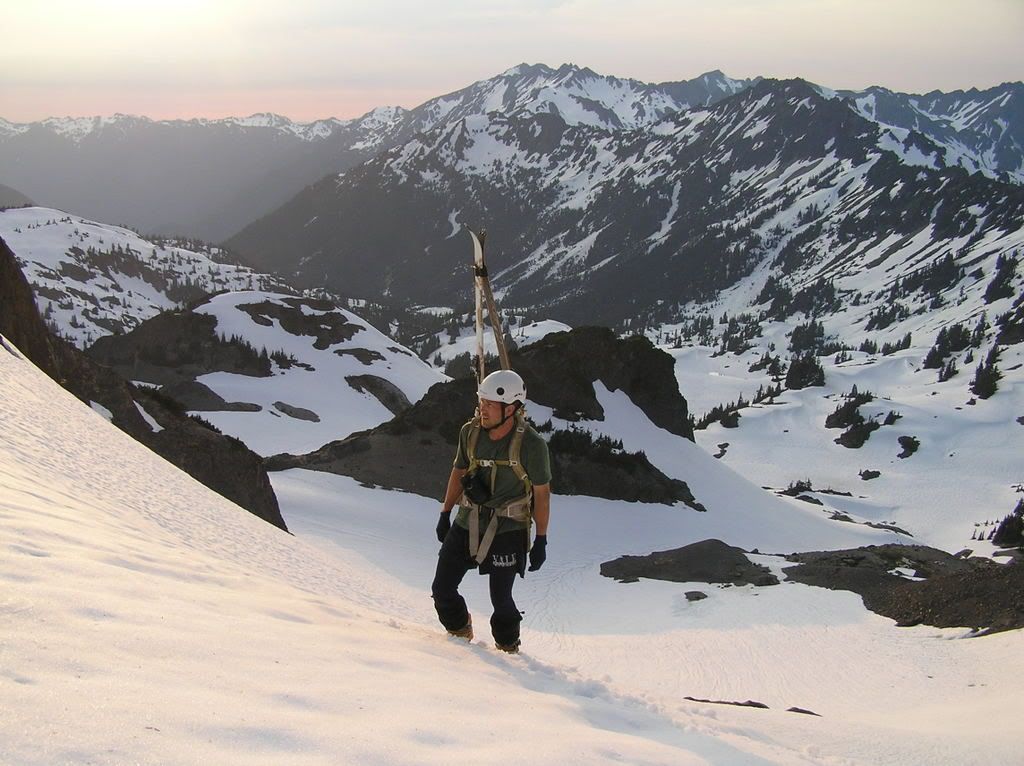
Expedition team: Tony DiBenedetto (Sequim) and Jason Bausher (Quinault)
I have dreamed about doing this for years.
After a failed winter attempt, we succeeded.
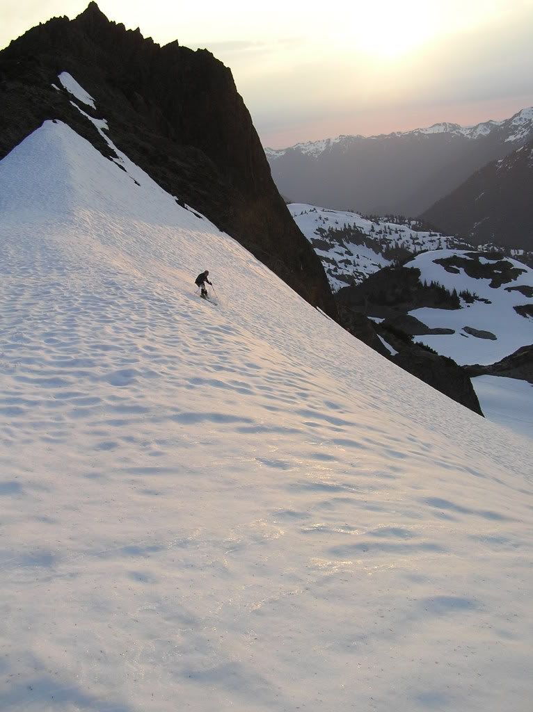
In this rare, late-lingering, huge snow pack we experienced the joy and pain of hauling heavy packs with ski gear from the Sol Duc trailhead, over the Bailey Range, to the Whiskey Bend trailhead in the Elwha. The expedition took us over the High Divide and the Catwalk, and over the summits of Mt. Carrie, Stephen Peak, Mt. Ferry, and Ludden Peak. Although restricted by spring conditions in lower elevations (below 4000 feet), we skied in coverage similar to winter for much of the alpine traverse.

Snow conditions for skiing were fantastic for this time of year in many places, but the snow conditions for travel were challenging at best due to hard snow in steep gullies. We skied smooth, sweet corn in the high country from the Sol Duc to Dodger Point. With long daylight, we were getting turns until 9:00 PM! Some of the most memorable runs were the descent from Ruth Peak to Stephen Lake and a 1,400' run north of the lake later that evening. However, we earned our turns: snow in the trees south of Cat Basin and in the gullies south of Cat Peak ranged from slush to hard snow. All of this crossed by side-hilling in rando boots. It took us 6 hrs to go 4 miles on the High Divide to side-hill the steep snow and avoid falling into high tree wells. Similar snow could be found on the east side past Ludden.
Ferry to Dodger 13 hrs
Ferry to Ludden base 7-11
Ludden base to summit 1 hr
Descend steep north cliffs 4.5 hr of 4th class
I am amazed at the edging ability of rando boots. They rock! We hiked and climbed in hiking boots only on the approaches (Sol Duc, Long Ridge, and Whiskey Bend).
Here is the trip itinerary:
Day 1: relaxing hike from Sol Duc trailhead up with day-hiking friends and family to Heart Lake and over to High Divide above Cat Basin. 3000 elevation gain hiking to Sol Duc River Crossing (full snow coverage above; high, thin snow bridges) Bridge Creek crossing (now a snow bridge) and skinned up to High Divided past Sol Duc Park and Heart Lake.
Day 2: skiing downhill to Cat Basin and skinned over to end of maintained trail when not side-hilling in boots on hard snow. Full snow coverage ended at the gullies and began alternating between snow and rock, slush and ice, and trees and exposed cliffs. Ascended snow to catwalk and crossed without incidentsomewhat more challenging with ski mountaineering packs. Camped on arm of Mt. Carrie and took 1000 sunset runs on corn above camp.
Day 3: climbed rock and steep snow to summit of Mt. Carrie and skied Carrie Glacier from summit to Ruth Peak. Climbed steep glacial ice and snow adjacent Ruth to gain passage to camp in Stephen basin via a 1000 ski run. Several hundred feet of Jason (an experienced mountaineer, but a novice skier) practicing on the fully-covered bowls around campbowls presenting options for skiing in 270 degrees of vision around camp. Skinned up to ridge from Stephen to Carrie for sunset views and another 1000 feet of skiing on corn.
Day 4: skied down to Stephen Lake, climbed up to Stephen Peak, and descended to Ferry Basin via the connecting ridge. Snow bridges made this route much easier than the heather/forest hike it is with less snow. Camped on bench below Ferry and above Ferry Basin. Skied north bowl of Ferry from summit to Ferry Basin1000 of corn and some ice.
Day 5: ascended Ferry and found no route to ski from summit to Ferry-Ludden ridge. Descended standard route of talus/scree and skied down to ridge. Hiked/skied to notch in ridge marking normal drop to Scott-Ludden saddle and ascended to Ludden summit. Sought north side of Ludden to avoid steep, hard (or slushy) snow with fatal consequences in gullies from Scott-Ludden saddle past Crislers Ladder to end of CCC trail. Found no grade one, class two, north route to ridge north of Ludden toward Dodger Point. Looks good on 7.5 map. Sounds good from OMR Climbers Guide route description. Not good. Here is the corrected rating: Grade II, Class 4. Class 4 definition: Simple climbing, often with exposure. A rope is often used. A fall on Class-4 rock could be fatal. Typically, natural protection can be easily found. Route from north side cliff is a cliffed-out bushwhack. Still better than steep, lower gullies with hard snow (maybe, but its a toss up). Camped near Dodger Point.
Day 6: skied couple runs on and around Dodger Point. One 2000 run from Dodger Point lookout down bowls and a creek slot. Skied with packs until snow ran out around 4700. Long hike on Long Ridge (Did I mention that the ridge is long?!).
Just in case you thought these were optional, these items are required for safety right now: helmet, rope, pickets, crampons, ice axe, rope, and minimal gear for protecting with natural anchors. If you do not know how to protect on snow, you should not be on this route right now. Contact the National Park Services Wilderness Information Center (WIC) at (360) 565-3100 for permit and regulation information and to see if you can get an updated report on conditions and/or climbing. Maybe you will reach Jason, who sometimes works at the WIC.
Entering/exiting via North Fork Quinault is not an option right now because the National Park Service has decreed it a felony to travel on the trail between Wild Rose Creek and the Low Divide because it is impassable. You will have to go out the Elwha the long way or the Skyline Traverse the brutal way. Watch out, brothers and sisters: the Bailey Range, too, is impassable!
I had the pleasure of doing this trip with my friend, Jason, who only recently purchased his first rando boots. Considering he has only skied a dozen times in his ski career, he did fantastic! Hats off to you, Jason. You the man!
Check out some videos and more photos at http://s292.photobucket.com/albums/mm12/tonyd54/Bailey%20Range%20Ski%20Traverse%202008/
Photobucket user name: tonyd54
Password: skicorn
Expedition team: Tony DiBenedetto (Sequim) and Jason Bausher (Quinault)
I have dreamed about doing this for years.
After a failed winter attempt, we succeeded.
In this rare, late-lingering, huge snow pack we experienced the joy and pain of hauling heavy packs with ski gear from the Sol Duc trailhead, over the Bailey Range, to the Whiskey Bend trailhead in the Elwha. The expedition took us over the High Divide and the Catwalk, and over the summits of Mt. Carrie, Stephen Peak, Mt. Ferry, and Ludden Peak. Although restricted by spring conditions in lower elevations (below 4000 feet), we skied in coverage similar to winter for much of the alpine traverse.
Snow conditions for skiing were fantastic for this time of year in many places, but the snow conditions for travel were challenging at best due to hard snow in steep gullies. We skied smooth, sweet corn in the high country from the Sol Duc to Dodger Point. With long daylight, we were getting turns until 9:00 PM! Some of the most memorable runs were the descent from Ruth Peak to Stephen Lake and a 1,400' run north of the lake later that evening. However, we earned our turns: snow in the trees south of Cat Basin and in the gullies south of Cat Peak ranged from slush to hard snow. All of this crossed by side-hilling in rando boots. It took us 6 hrs to go 4 miles on the High Divide to side-hill the steep snow and avoid falling into high tree wells. Similar snow could be found on the east side past Ludden.
Ferry to Dodger 13 hrs
Ferry to Ludden base 7-11
Ludden base to summit 1 hr
Descend steep north cliffs 4.5 hr of 4th class
I am amazed at the edging ability of rando boots. They rock! We hiked and climbed in hiking boots only on the approaches (Sol Duc, Long Ridge, and Whiskey Bend).
Here is the trip itinerary:
Day 1: relaxing hike from Sol Duc trailhead up with day-hiking friends and family to Heart Lake and over to High Divide above Cat Basin. 3000 elevation gain hiking to Sol Duc River Crossing (full snow coverage above; high, thin snow bridges) Bridge Creek crossing (now a snow bridge) and skinned up to High Divided past Sol Duc Park and Heart Lake.
Day 2: skiing downhill to Cat Basin and skinned over to end of maintained trail when not side-hilling in boots on hard snow. Full snow coverage ended at the gullies and began alternating between snow and rock, slush and ice, and trees and exposed cliffs. Ascended snow to catwalk and crossed without incidentsomewhat more challenging with ski mountaineering packs. Camped on arm of Mt. Carrie and took 1000 sunset runs on corn above camp.
Day 3: climbed rock and steep snow to summit of Mt. Carrie and skied Carrie Glacier from summit to Ruth Peak. Climbed steep glacial ice and snow adjacent Ruth to gain passage to camp in Stephen basin via a 1000 ski run. Several hundred feet of Jason (an experienced mountaineer, but a novice skier) practicing on the fully-covered bowls around campbowls presenting options for skiing in 270 degrees of vision around camp. Skinned up to ridge from Stephen to Carrie for sunset views and another 1000 feet of skiing on corn.
Day 4: skied down to Stephen Lake, climbed up to Stephen Peak, and descended to Ferry Basin via the connecting ridge. Snow bridges made this route much easier than the heather/forest hike it is with less snow. Camped on bench below Ferry and above Ferry Basin. Skied north bowl of Ferry from summit to Ferry Basin1000 of corn and some ice.
Day 5: ascended Ferry and found no route to ski from summit to Ferry-Ludden ridge. Descended standard route of talus/scree and skied down to ridge. Hiked/skied to notch in ridge marking normal drop to Scott-Ludden saddle and ascended to Ludden summit. Sought north side of Ludden to avoid steep, hard (or slushy) snow with fatal consequences in gullies from Scott-Ludden saddle past Crislers Ladder to end of CCC trail. Found no grade one, class two, north route to ridge north of Ludden toward Dodger Point. Looks good on 7.5 map. Sounds good from OMR Climbers Guide route description. Not good. Here is the corrected rating: Grade II, Class 4. Class 4 definition: Simple climbing, often with exposure. A rope is often used. A fall on Class-4 rock could be fatal. Typically, natural protection can be easily found. Route from north side cliff is a cliffed-out bushwhack. Still better than steep, lower gullies with hard snow (maybe, but its a toss up). Camped near Dodger Point.
Day 6: skied couple runs on and around Dodger Point. One 2000 run from Dodger Point lookout down bowls and a creek slot. Skied with packs until snow ran out around 4700. Long hike on Long Ridge (Did I mention that the ridge is long?!).
Just in case you thought these were optional, these items are required for safety right now: helmet, rope, pickets, crampons, ice axe, rope, and minimal gear for protecting with natural anchors. If you do not know how to protect on snow, you should not be on this route right now. Contact the National Park Services Wilderness Information Center (WIC) at (360) 565-3100 for permit and regulation information and to see if you can get an updated report on conditions and/or climbing. Maybe you will reach Jason, who sometimes works at the WIC.
Entering/exiting via North Fork Quinault is not an option right now because the National Park Service has decreed it a felony to travel on the trail between Wild Rose Creek and the Low Divide because it is impassable. You will have to go out the Elwha the long way or the Skyline Traverse the brutal way. Watch out, brothers and sisters: the Bailey Range, too, is impassable!
I had the pleasure of doing this trip with my friend, Jason, who only recently purchased his first rando boots. Considering he has only skied a dozen times in his ski career, he did fantastic! Hats off to you, Jason. You the man!
Check out some videos and more photos at http://s292.photobucket.com/albums/mm12/tonyd54/Bailey%20Range%20Ski%20Traverse%202008/
Photobucket user name: tonyd54
Password: skicorn
Very cool tour Tony. Thanks for sharing and welcome to the board. I will look forward to hearing about your next adventure.
Nice trip on the windward side of the range. The Bailey's look so tempting from hurricane ridge. But what a challenge to access them. Good job.
Good job, Sequim-Man. Sending PM.
Hey thanks for the kudos people!
You know I actually skied the Carrie Glacier many years ago one August while on a backing trip with my wife. I day hiked up with some ultra light rando gear, but the snow was very hard and sun cuppy so it wasn't much fun. I always thought an earlier spring trip would be great, or in this case a lingering winter. On this recent trip with that week of hot weather we just had, the snow was forming sun cups by the time we got to Dodger. We really hit it perfect. I am so pleased.
Tony
Glad to see someone accessing that amazing terrain.
Congrads on a sick tour
Congrads on a sick tour
author=Kyle Miller link=topic=10545.msg42751#msg42751 date=1215041326]
Glad to see someone accessing that amazing terrain.
Congrads on a sick tour
Ditto that. Nice pics.
Reply to this TR
Please login first: