June 28, 2008, Mt. Adams SW chute
6/28/08
WA Cascades West Slopes South (Mt Rainier)
9539
18
We drove nearly to Morrison camp, started way too late, though it might not have mattered since there was likely no freeze overnight even at Piker's Peak. We walked the road for a mile or so, then went straight to Cold Springs camp, skipping road switchbacks. Skied continuous snow from there. SW chute gave us 4-6" slush everywhere, even when we tried slightly different aspects. Only a dozen folks in the chutes all day today. We headed straight for Morrison camp on the way out, interesting skiing in fairly open forest, crisscrossing streams on snowbridges. 7000+ vertical, I'm tired.
Our party skied Adams on Wednesday and Thursday (25th, 26th) and had good conditions. We elected to follow the drainage rather than the road and saved a bunch of time to our 7000 ft camp. We skied the sw chutes Wednesday and had somewhat soft, but overall excellent conditions all the way down (far skiers left chute held the best corn). We elected to high traverse at 7000 ft and with all the snow it took very little effort to get back to our camp. Thursday we skied off the summit, with limited vis due to a lenticular, with mushy but very skiable corn and finished on the south climb down back to camp -- starting to cup in spots, but smooth areas could be found on the margins. Not a soul was up there all day, but the wind was howling. Skied back out the Morrison drainage to almost 1/2 a mile from the car -- very fun patch skiing.
Yep - t'was warm up there. I skied middling to good corn from ~9k at 9 am Sunday on the north side. Glad to hear the Morrison patches are still holding together. There's a lot more snow on the west side than the north.
And for some photo's.
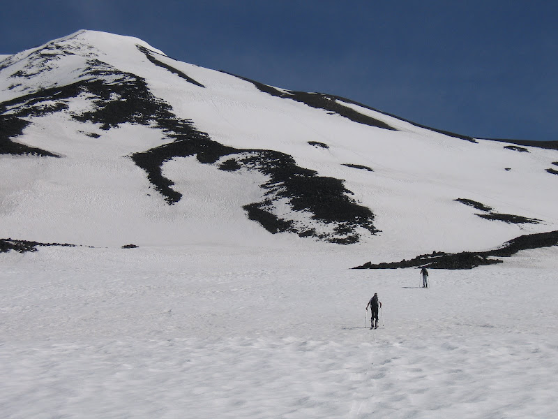
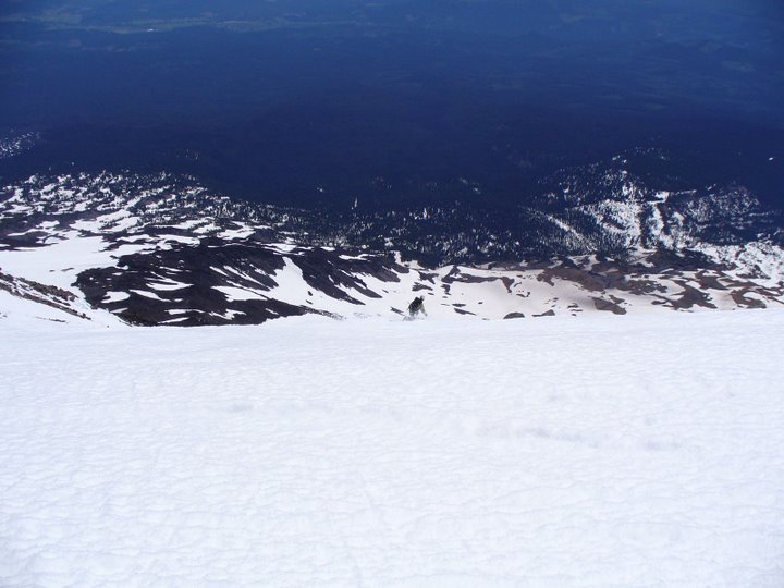
Here's a photo of the south climb on June 26th
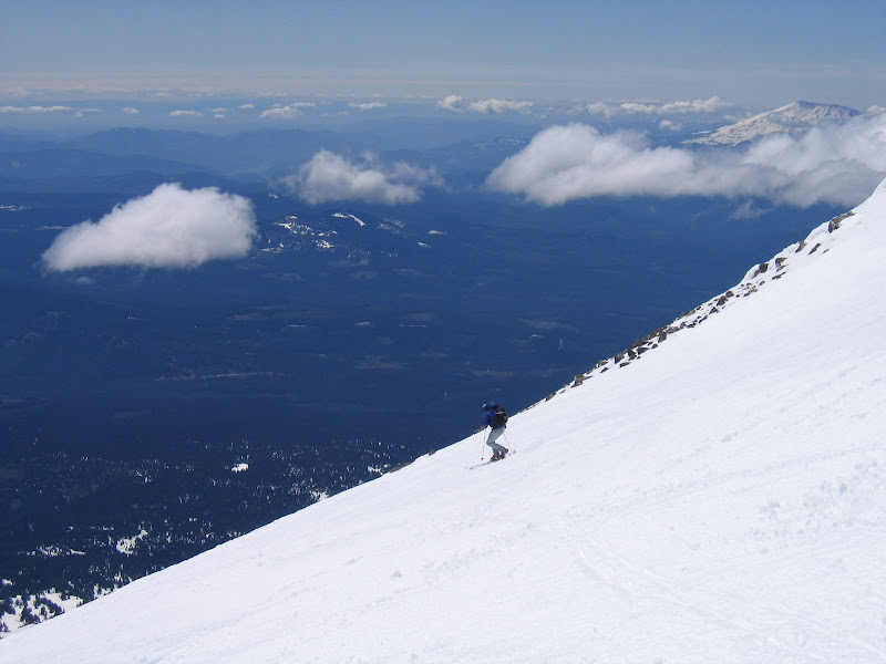
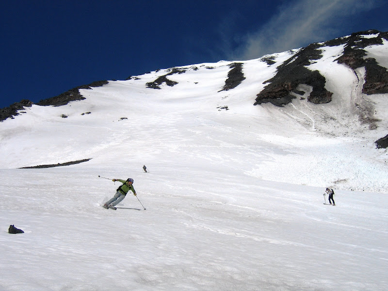
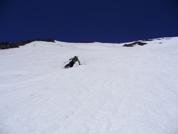
Buck in the SW chutes on June 25th
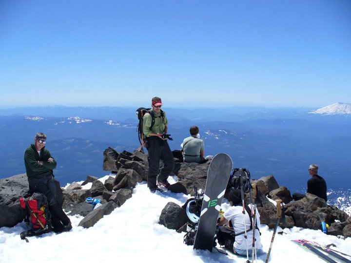
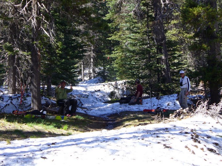
Buck, Hambone and Evan at the bottom of the chutes
Here's a photo of the south climb on June 26th
Buck in the SW chutes on June 25th
Buck, Hambone and Evan at the bottom of the chutes
Looks like a good time! Thanks for posting the photos showing how the routes look overall. How close to the trailhead can you drive now?
You can get to Morrison Creek Campground -- I believe that is 3.5 miles from Cold Springs. With a GPS, map and compass, and not minding a bushwhack, I recommend the direct line up the drainage, leaving from the campground. In fact, a trail I was not previously aware of takes you for at least 1/4 of a mile before being lost in the snow.
Nice work posting photos Zeno, I'm way too much of a slacker.
Nice work posting photos Zeno, I'm way too much of a slacker.
author=Buck link=topic=10490.msg42613#msg42613 date=1214864082]
You can get to Morrison Creek Campground -- I believe that is 3.5 miles from Cold Springs. With a GPS, map and compass, and not minding a bushwhack, I recommend the direct line up the drainage, leaving from the campground. In fact, a trail I was not previously aware of takes you for at least 1/4 of a mile before being lost in the snow.
IMHO it is easier to walk the road from Morrison a mile or so (until you have crossed from steep hillside to a gradual ridgecrest) and then follow the easy ridgecrest (a light trail exists) to continuous snow just below Cold Springs. We did this Saturday and found it led us right by Cold Springs camp in an hour with no roads to switchback. Going directly up the drainage is not so easy travel and involves more routefinding to get over to the south ridge route up Adams, if you prefer a challenge.
Thanks Silas,
Good timing, we were just discussing your approach, not having done this before. Your input is very handy. Did you carry hiking boots and switch to ski boots?
Thanks,
Joe
Good timing, we were just discussing your approach, not having done this before. Your input is very handy. Did you carry hiking boots and switch to ski boots?
Thanks,
Joe
We too skied the SW Chutes on Saturday. Left Morrison Creek @ 2:30a and went up the Morrison Creek trail / drainage. I found this way pretty straight forward and it didn't seem like a bushwhack at all, in fact, I think I only got hit in the face by a couple branches. Can it really be a bushwhack if the Devils Club and Slide Alder is still covered up? We were able to navigate it by headlamp having chatted with some guys in the parking lot and guessed on the route from above in previous years.
We got to Pikers Peak between 9:30 and 10, waited 'till 11 but the top wasn't right yet, headed down at 12 and found good conditions. Were able to ski to about 5K and 1/2 mile to the car...good times...
We got to Pikers Peak between 9:30 and 10, waited 'till 11 but the top wasn't right yet, headed down at 12 and found good conditions. Were able to ski to about 5K and 1/2 mile to the car...good times...
I agree. The way was virtually a straight line on the map, making for an easy compass bearing, and saved us a bunch of time. It is more challenging than the road in route finding, but if you plan on taking the drainage back to the car (fun bonus skiing) if is wise to climb the drainage first.
Heya Silas - missed you by a day on the chutes; we (Carter, Drew, and I) camped near treeline Saturday night at skied the chutes at about noon on Sunday. Great corn on a firm base in the lower portion of the chutes, but somewhat of a mushy base in the upper portion (didn't seem to have refroze much on Sat. night, and the base seemed more consolidated down lower). Pics posted here.
The sky had been clear all day, but dark clouds began to build as we hiked down the road from Cold Springs (very glad to have brought approach shoes as to avoid hiking in ski boots). Made it back to the car just before a huge thunderstorm charged in; I don't think I've ever seen hail that intense in Washington before (about marble-size pellets bombarding the car with lightening crashes rather closeby). Drove about 30 miles before getting out of the storm south of Trout Lake. Hopefully other parties out on the mountain fared alright!?! That was quite a storm!
The sky had been clear all day, but dark clouds began to build as we hiked down the road from Cold Springs (very glad to have brought approach shoes as to avoid hiking in ski boots). Made it back to the car just before a huge thunderstorm charged in; I don't think I've ever seen hail that intense in Washington before (about marble-size pellets bombarding the car with lightening crashes rather closeby). Drove about 30 miles before getting out of the storm south of Trout Lake. Hopefully other parties out on the mountain fared alright!?! That was quite a storm!
We skied the SW Chutes on Sat. as well. Not sure who on here I might have seen up there, but maybe we crossed paths. We left the car at 5:30 am, hiked along the road to Cold Springs, more or less followed the flagged route up to the ridge and the lunch counter. The long slog up to Piker's Peak just about killed me so we called it good there at about 12:30. Hung out with several other skiers and climbers for an hour or so before heading down, even though there was no need to wait for anything to soften up, as things were plenty mushy- it was a warm one up on the mountian that day- pretty sure there was no freezing going on the previous night. The chutes were getting a little bumpy in spots, but we were still able to find some nice smooth areas where we could carve some big turns in the overly baked snow. We set off a couple small sloughs. At the bottom of the chutes we traversed over a couple ridges around timberline until what we thought was the Morrison Creek drainage (and it turned out we were right!) After skiing through the trees and down waterfalls we came across a group heading up who told us the route back to Morrison Creek campground was flagged. We somewhat successfully followed the red flags until we ran out of snow then it was probably only about a 1/2 hour hike out to the road. This was much better than hiking back out through Cold Springs along the road.
Rob and I also skied the chutes on Saturday around 12:15. It looks as if almost everyone we saw up there posted. We started out at 3:30 am from the camper and took about an hour hike to get up to Cold Springs. It was really hot on the climb up Pikers Peak. After skiing the chutes (what a great line) and having lunch, we ran into two other skiers looking for the path out. We skied down the Morrison Creek drainage and found that a very direct route back home. It was a pleasure not having to hike back to Timberland Camp! After having skied down Morrison Creek, I would definitely use this as a more direct approach route. The drainage stays much cooler than the road and the skins can go on earlier. That being said, if it were my first time through Morrison Creek I could see it could possibly lead to a bit of bushwacking trying to follow the flagged trail with headlamps. Ben, great meeting you and thanks for greeting us with the cold PBR's at trails end!
So...are people driving from the Seattle area taking I-5 to the river and then east, or are any of the inland forest road routes open?
Nice to meet you also Dave. Glad we found a fairly direct route out. I still wish I would have skied that second waterfall ;) Here's a picture of us at the end of the snow, looking forward to those beers.
Wow, still snow down to Morrison Crk. Pretty late year indeed. I too would suggest the trek up Morrison Crk. drainage when it has adequate snow More snow cover lets you skin up where as the road is probably mostly bare. Having done both, I can attest that it's faster and a shorter hike going up the drainage + gliding my skis along always feels better than having to carry em.
author=cascadesfreak link=topic=10490.msg42648#msg42648 date=1214892682]
The sky had been clear all day, but dark clouds began to build as we hiked down the road from Cold Springs (very glad to have brought approach shoes as to avoid hiking in ski boots). Made it back to the car just before a huge thunderstorm charged in; I don't think I've ever seen hail that intense in Washington before (about marble-size pellets bombarding the car with lightening crashes rather closeby). Drove about 30 miles before getting out of the storm south of Trout Lake. Hopefully other parties out on the mountain fared alright!?! That was quite a storm!
Our party of Snowbell, Nick BC and myself must have been two hours behind you down the Chutes. We had just reached our stashed boots and beer at timberline when the 4th of July fireworks started. We sought refuge in the hothouses at Cold Springs and, too, thought about any poor souls caught on the open mountain side.
author=andyski link=topic=10490.msg42685#msg42685 date=1214958579]
So...are people driving from the Seattle area taking I-5 to the river and then east, or are any of the inland forest road routes open?
If I-5 is too busy Seattle to Olympia, a very pleasant alternative, only 30 miles longer and quite likely shorter timewise, is I-90 to I-82, then US97 through Toppenish, then west from Maryhill (thanks Brian!)
author=Joedabaker link=topic=10490.msg42628#msg42628 date=1214878700]
Did you carry hiking boots and switch to ski boots?
We just hiked in our ski boots, which for me was not uncomfortable for the mile or so we hiked: I have TLT4 boots, not quite as stiff as the big high performance boots. As for the Morrison Creek vs Cold Springs approach banter, I suspect this week of warm weather will tip the scale toward Cold Springs (though it was already tipped for me :)) If the road is still blocked by snow, just make sure not to follow the road all the way, but rather the broad ridgecrest to Cold Springs. Hope you can still ski to 5000' or lower.
author=silaswild link=topic=10490.msg42769#msg42769 date=1215047243]Nice! At least some variety.
If I-5 is too busy Seattle to Olympia, a very pleasant alternative, only 30 miles longer and quite likely shorter timewise, is I-90 to I-82, then US97 through Toppenish, then west from Maryhill (thanks Brian!)
Reply to this TR
Please login first: