June 1, 2008, Mt Chiquita (13,069'), Banana Couloir
6/1/08
3341
1
Day 49
6-1-08
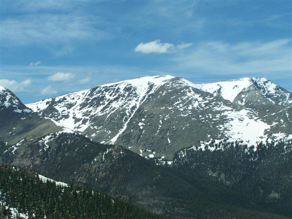
Mt Chiquita (13,069), Banana Couloir
Distance traveled: 10 miles
Total vertical skied: 4,200 VF
I looked at my altimeter again, doing a little reconciliation in my head: 9,400 feet. Considering the altimeter was off by 800 VF on the summit, I expected a similar miss on the valley floor. The road must be close, I said to Sean. Again.
***
Wed been bushwhacking since 11 am, and it was getting on toward 12:30 pm. Up to that point we were right on schedule. A suicidal schedule for sure, but amazingly wed kept it: 4:15 am meeting at SW Estes, 5 am drop Subaru at Endovalley (8,400'), 5:45 at the visitors center at 11,800. Wed been able to ski down the 1.5 2 miles of the snow covered Fall River road to Chapin Pass Trailhead (10,600), and that had been an unexpected bonus and probably kept us on track to reach the summit by 9 am. The hike was spectacular, mostly above tree line along snowfields and tundra. When we reached the summit, though, the snow was much firmer on the 45 degree headwall than the south facing run and warm temps would have suggested. We ended up waiting about 45 minutes for the sun to do its work. My impatience and the promise of sloppy snow down low pushed us to go, or we would have waited longer.
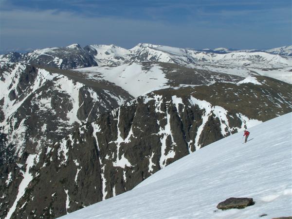
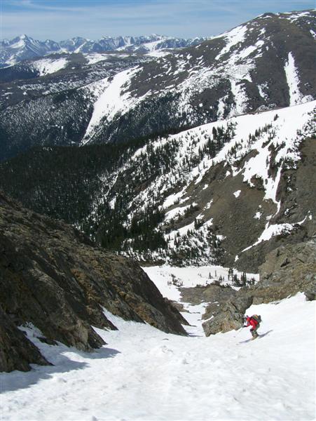
The ski down the Banana was very intimidating off the top. Even with the little extra time, the surface was still a frozen/firm corn surface that started gentle and rolled away to reveal the valley floor 2,000 feet below. I kicked myself for being such a pansy; Id skied in the Whites with boilerplate and no redeeming corn so this shouldnt have been that bad. And sure enough, it wasnt - at least once you reached the point on the headwall where you could see the route below. We skied in short sections down off the headwall, and then had a rip-roaring good time in the throat and slide fan below, the debris strewn slope enjoyable due to the 4-5 of corn that covered it.
At the valley floor we found a few short open shots in the forest following the Chiquita creek, but I came grinding to a halt after about 3K feet from the summit. Now it was time to pay the piper. I had no snowshoes (fast and light was the name of the game) as I was gambling that I could ski down to snowline. I was a little disappointed and very nervous therefore when I stopped with 4 feet of snow still surrounding me. Oh-oh. But luckily the snow was no deeper than my thighs so even though I plunged through every now and then, at least I crashed to the ground and was not subjected to a bottomless wallow. Most of the time. Regardless, it was still tiring, difficult and unpleasant work. Deadfall, hidden logs and underbrush made for very trying travel.
Sean and I crashed down through the forest following the creek, crossing and re-crossing as we followed elusive/illusionary herd paths. After a half hour we left the snow, but the forest remained dense, the travel remaining difficult. The only redeeming aspect was that the route was down hill. I think I would have killed myself if it was a climb.
Eventually, 4,500 feet from the summit, the bottom of the Fall River road appeared, complete with milling groups of tourists, and my car was a short stroll away. Luxury!
6-1-08
Mt Chiquita (13,069), Banana Couloir
Distance traveled: 10 miles
Total vertical skied: 4,200 VF
I looked at my altimeter again, doing a little reconciliation in my head: 9,400 feet. Considering the altimeter was off by 800 VF on the summit, I expected a similar miss on the valley floor. The road must be close, I said to Sean. Again.
***
Wed been bushwhacking since 11 am, and it was getting on toward 12:30 pm. Up to that point we were right on schedule. A suicidal schedule for sure, but amazingly wed kept it: 4:15 am meeting at SW Estes, 5 am drop Subaru at Endovalley (8,400'), 5:45 at the visitors center at 11,800. Wed been able to ski down the 1.5 2 miles of the snow covered Fall River road to Chapin Pass Trailhead (10,600), and that had been an unexpected bonus and probably kept us on track to reach the summit by 9 am. The hike was spectacular, mostly above tree line along snowfields and tundra. When we reached the summit, though, the snow was much firmer on the 45 degree headwall than the south facing run and warm temps would have suggested. We ended up waiting about 45 minutes for the sun to do its work. My impatience and the promise of sloppy snow down low pushed us to go, or we would have waited longer.
The ski down the Banana was very intimidating off the top. Even with the little extra time, the surface was still a frozen/firm corn surface that started gentle and rolled away to reveal the valley floor 2,000 feet below. I kicked myself for being such a pansy; Id skied in the Whites with boilerplate and no redeeming corn so this shouldnt have been that bad. And sure enough, it wasnt - at least once you reached the point on the headwall where you could see the route below. We skied in short sections down off the headwall, and then had a rip-roaring good time in the throat and slide fan below, the debris strewn slope enjoyable due to the 4-5 of corn that covered it.
At the valley floor we found a few short open shots in the forest following the Chiquita creek, but I came grinding to a halt after about 3K feet from the summit. Now it was time to pay the piper. I had no snowshoes (fast and light was the name of the game) as I was gambling that I could ski down to snowline. I was a little disappointed and very nervous therefore when I stopped with 4 feet of snow still surrounding me. Oh-oh. But luckily the snow was no deeper than my thighs so even though I plunged through every now and then, at least I crashed to the ground and was not subjected to a bottomless wallow. Most of the time. Regardless, it was still tiring, difficult and unpleasant work. Deadfall, hidden logs and underbrush made for very trying travel.
Sean and I crashed down through the forest following the creek, crossing and re-crossing as we followed elusive/illusionary herd paths. After a half hour we left the snow, but the forest remained dense, the travel remaining difficult. The only redeeming aspect was that the route was down hill. I think I would have killed myself if it was a climb.
Eventually, 4,500 feet from the summit, the bottom of the Fall River road appeared, complete with milling groups of tourists, and my car was a short stroll away. Luxury!
awesome man! coverage looks better than when I skiied it 3 years ago, that's a pretty nasty shwack out of Chaplin canyon too, I remmember trying to follow those same elk paths. nice work
Reply to this TR
Please login first: