May 17-22, 2008, Sierra Nevada: Saddlebag Lake to T
5/17/08
US elsewhere
4069
1
Previous trips to the Sierra had been great (http://www.turns-all-year.com/skiing_snowboarding/trip_reports/index.php?topic=4726.0 and http://www.turns-all-year.com/skiing_snowboarding/trip_reports/index.php?topic=2905.0) so it was high time for some more time in that range.
Tyler, Lindsey and I flew down and met up with Mark, a ttips-ster from the Bay Area, and headed over to the east side of the range. Our original plans called for a trip into the Ionian Basin area of Kings Canyon NP to climb and ski Mt. Goddard but after reading reports from TonyM (http://www.turns-all-year.com/skiing_snowboarding/trip_reports/index.php?topic=10033.0) and others it seemed like the snow pack in the southern end of the range wasn't in shape for such a trip so we opted to do a trip further north where we heard the snow was better and settled on a route from Saddlebag Lake to Twin Lakes. They had lots of high winds this past winter and all the high peaks and passes in the southern part of the range were essentially scoured of snow.
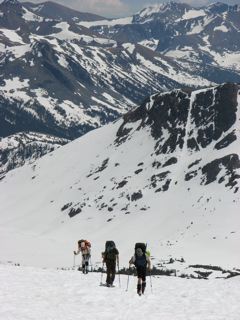
A few photos of our trip are below. For more: http://flickr.com/photos/8621007@N07/sets/72157605231002284/
After stocking up the night before at the Whoa Nellie Dellie (highly recommend the cheesecake), a huge breakfast at the Hays Street cafe in Bridgeport the following morning, and arranging the car shuttle (a fee and permit are necessary to leave a car at Twin Lakes, you can stash food and other things at the Twin Lakes store if you don't want to leave it for the bears in your car), we set off under sunny skies and very warm temps with plans for a 6-day trip. There were lots of bare spots on the road leading up to Saddlebag Lake but we managed to find fairly consistent coverage in river valley below the road leading up to the lake and had skis on most of the way.. Once we arrived at the lake, we had continuous snow coverage all the way out to our campsite on a rocky prominence near Wasco Lake with great views of Mt. Conness and North Peak. After setting up camp, we set out to ski some north facing slopes on the ridge coming off Conness. Despite the late hour and the very warm temps, these aspects held some great corn and little in the way of sun cups.
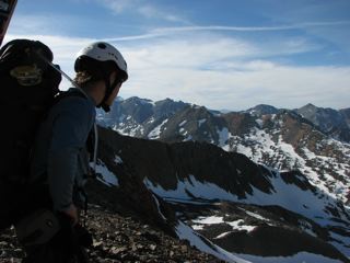
Day 2 arrived with clear skies and warm temps again. We planned a layover day to explore the area, eat our food and lighten our packs before moving on and decided to climb and ski North Peak. We climbed to the slopes above Conness Lakes and ascended a steep, snow-covered slope to the summit ridge, skinning part of the way and booting the rest. After taking in some great summit views, we moved down the ridge and skied the slope a bit west of where we had ascended. By that point, the south facing slope was pretty cooked and the skiing was on the so-so side. Remembering, how well the north facing slopes off Conness held up the day before, we decided to cross the valley and get up to the ridge again. That afforded some more great views and a really sweet ride back down to Conness Lakes and our camp. If you were fast and the snow was in good shape, it would be possible to knock off North Peak and Conness in the same day.
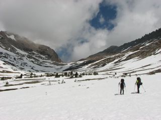
Day 3 was our day to cover some terrain. With the packs feeling lighter, we headed out the valley, climbing the slopes above and to the west of Steelhead lake. We then traversed northeast a bit and then booted up slopes to an unnamed pass that sits east of Sheppherd Crest. After a short lunch, we skied off the pass down to a small unnamed tarn on some nice corn snow, then redonned the skins. The route from here involved climbing up to and over Excelsior Mountain. We had good snow coverage on the lower part of the ascent but did a lot of ski-carrying once up on the summit ridge. Didn't matter too much as the weight was more than offset by the amazing views of northern Yosemite while trapsing on the ridge. Once over the summit, we traversed on foot on the west side of the peak until arriving at the pass we would access to drop to the east side of the crest and down to Summit Lake. Fewer turns than anticipated were possible off the pass due to poor snow coverage but we found a north facing gully off to our left that provided some nice turns as we headed down to the benches above (southeast) of Summit Lake. Way better to go down this gully than to have to walk all the way around on the bare rock to pick up the summer trail as we feared we might have to do.
On the morning of Day 4, we awoke to gale force winds that wreaked havoc on Mark's Betamid and made for a brisk morning. Little did we anticipate at this point that the winds would keep up in a big way all day and we would have a bit of an epic adventure. Once packed up, we headed down to and around the north side of Summit Lake. We crosse back into Yosemite and started to head up towards the area below Virginia Pass. We had to drop down a bit in elevation in an attempt to find snow coverage as the slopes below Camiaca Peak were pretty barren. After booting it a bit through the forest, we found continuous snow, put back on the skis and headed towards the area beyond Return Lake where we would encounter the crux of the route -- Stanton Col. After skiing, then bushwhacking a bit through talus and brush (still tamer than anything you would encounter in the cascades) to the base of the slope below pass, we booted up to the top only to find no adequate way down the other side. RJ Secor lists it as a Class 3 pass and Mark had even done it about 10 years prior but we couldn't find an adequate way down the steep, very blocky slopes. So... back down to the base of the slope and figure out a Plan B. The maps indicated we might be able to drop down to Spiller Lake instead, so we headed up that direction to take a look. By this point, the wind was really gusting... so hard at points that me and Tyler were actually blown over while standing still looking at our map! After beating around a bit on the ridges and plateau northeast of Spiller Lake we spied a steep couloir we thought would get us down to the lake. Some steep but soft snow at the top led down to a loose, steep rocky slope that we navigated slowly, eventually popping out at lake level. Our slow descent provided ample time to watch the sun set on the horizon. Once down, we skied around the lake and managed to find a nice, sheltered camp just west of the lake with dry ground and running water (we called it Salvation Camp) and settled in for the night, thankful to be off that pass in one piece.
Day 5 brought sunny skies and less wind in our sheltered spot so we took advantage and lounged around a bit. Poking around Spiller Lake we looked back at the slope we had come down the night before. From that vantage point, it looked even less appealing than the night before... almost undoable. "What were we thinking?" was a common refrain at that point. The better route down would have been to follow the ridge above and east of the lake all the way down as it curled to the southeast shore of the lake. Always easier to see in hindsight, we figured. Sufficiently rested, we headed off towards the days objective... Horsecreek Pass. We dropped off our plateau down into the Spiller Creek drainage. The skiing down the valley wasn't great as the winds were blowing and the slopes hadn't softened much. Once in the valley, we had a great ski up to the pass with amazing views of Whorl Mountain and Matterhorn Peak the entire way. After lunch at the pass, we dropped off the other side into the Horsecreek drainage and found wonderful corn and little in the way of suncups, perhaps the best ski conditions of the trip, all the way down to our camp at 9000 feet in the basin below Twin Peaks and Matterhorn Peak. After setting up camp, Tyler and I climbed up to a high bowl below the peaks and enjoyed a nice run back down to camp with crusty snow up high but nice corn down low.
We had sun at the start of dinner but by the end, we noticed some big clouds moving in down valley and eventually spied what looked like precip in the distance. Into the tents we headed right before it arrived at our camp. We awoke the following morning to cold temps and 2-3 inches of light, low density powder and blowing winds. What we thought would just be a bit of late evening day-weather turned out to be a new system that had rolled through. So much for those forecasts we checked right before the trip which called for 7 straight days of sun and warm temps. All of a sudden my bivy sack as shelter plan was looking less wise. Not easy getting in and out of that thing without letting tons of snow in! We threw down our breakfast and packed up, skiing what turned out to be some fairly nice dust on crust down Horse Creek before picking up the trail and booting it out to Twin Lakes where we had our last navigation issues figuring out how to get to the campground and our car. Nary a soul fishing on the lakes as the winds were high and the temps were cold. No need to brave the cold for some fishing when you can have all the comforts of home -- including Direct TV satellite feeds -- in those big RVs!
We finished off the day by retrieving our car and wolfing down an obscene amount of food at the Whoa Nellie Delie yet again (went for the baby back ribs this time... Mmmm).
Overall, another great trip. Lots of great terrain. Less walking than we anticipated too. The coverage was thin in many spots but it's amazing how far you can go on just 6 inches to one foot of well consolidated snow! Lindsey gets major kudos as this was her first extended backcountry ski tour and she handled it all like it was nothing!
Doubt the route will be in shape much longer this season unless the latest storm cycle brings a lot of snow but this is a good one to stock away for future plans if you want to see some great country and ski some nice slopes.
An Additional TR with more photos:
http://www.telemarktalk.com/phpBB/viewtopic.php?p=789198#789198
Tyler, Lindsey and I flew down and met up with Mark, a ttips-ster from the Bay Area, and headed over to the east side of the range. Our original plans called for a trip into the Ionian Basin area of Kings Canyon NP to climb and ski Mt. Goddard but after reading reports from TonyM (http://www.turns-all-year.com/skiing_snowboarding/trip_reports/index.php?topic=10033.0) and others it seemed like the snow pack in the southern end of the range wasn't in shape for such a trip so we opted to do a trip further north where we heard the snow was better and settled on a route from Saddlebag Lake to Twin Lakes. They had lots of high winds this past winter and all the high peaks and passes in the southern part of the range were essentially scoured of snow.
A few photos of our trip are below. For more: http://flickr.com/photos/8621007@N07/sets/72157605231002284/
After stocking up the night before at the Whoa Nellie Dellie (highly recommend the cheesecake), a huge breakfast at the Hays Street cafe in Bridgeport the following morning, and arranging the car shuttle (a fee and permit are necessary to leave a car at Twin Lakes, you can stash food and other things at the Twin Lakes store if you don't want to leave it for the bears in your car), we set off under sunny skies and very warm temps with plans for a 6-day trip. There were lots of bare spots on the road leading up to Saddlebag Lake but we managed to find fairly consistent coverage in river valley below the road leading up to the lake and had skis on most of the way.. Once we arrived at the lake, we had continuous snow coverage all the way out to our campsite on a rocky prominence near Wasco Lake with great views of Mt. Conness and North Peak. After setting up camp, we set out to ski some north facing slopes on the ridge coming off Conness. Despite the late hour and the very warm temps, these aspects held some great corn and little in the way of sun cups.
Day 2 arrived with clear skies and warm temps again. We planned a layover day to explore the area, eat our food and lighten our packs before moving on and decided to climb and ski North Peak. We climbed to the slopes above Conness Lakes and ascended a steep, snow-covered slope to the summit ridge, skinning part of the way and booting the rest. After taking in some great summit views, we moved down the ridge and skied the slope a bit west of where we had ascended. By that point, the south facing slope was pretty cooked and the skiing was on the so-so side. Remembering, how well the north facing slopes off Conness held up the day before, we decided to cross the valley and get up to the ridge again. That afforded some more great views and a really sweet ride back down to Conness Lakes and our camp. If you were fast and the snow was in good shape, it would be possible to knock off North Peak and Conness in the same day.
Day 3 was our day to cover some terrain. With the packs feeling lighter, we headed out the valley, climbing the slopes above and to the west of Steelhead lake. We then traversed northeast a bit and then booted up slopes to an unnamed pass that sits east of Sheppherd Crest. After a short lunch, we skied off the pass down to a small unnamed tarn on some nice corn snow, then redonned the skins. The route from here involved climbing up to and over Excelsior Mountain. We had good snow coverage on the lower part of the ascent but did a lot of ski-carrying once up on the summit ridge. Didn't matter too much as the weight was more than offset by the amazing views of northern Yosemite while trapsing on the ridge. Once over the summit, we traversed on foot on the west side of the peak until arriving at the pass we would access to drop to the east side of the crest and down to Summit Lake. Fewer turns than anticipated were possible off the pass due to poor snow coverage but we found a north facing gully off to our left that provided some nice turns as we headed down to the benches above (southeast) of Summit Lake. Way better to go down this gully than to have to walk all the way around on the bare rock to pick up the summer trail as we feared we might have to do.
On the morning of Day 4, we awoke to gale force winds that wreaked havoc on Mark's Betamid and made for a brisk morning. Little did we anticipate at this point that the winds would keep up in a big way all day and we would have a bit of an epic adventure. Once packed up, we headed down to and around the north side of Summit Lake. We crosse back into Yosemite and started to head up towards the area below Virginia Pass. We had to drop down a bit in elevation in an attempt to find snow coverage as the slopes below Camiaca Peak were pretty barren. After booting it a bit through the forest, we found continuous snow, put back on the skis and headed towards the area beyond Return Lake where we would encounter the crux of the route -- Stanton Col. After skiing, then bushwhacking a bit through talus and brush (still tamer than anything you would encounter in the cascades) to the base of the slope below pass, we booted up to the top only to find no adequate way down the other side. RJ Secor lists it as a Class 3 pass and Mark had even done it about 10 years prior but we couldn't find an adequate way down the steep, very blocky slopes. So... back down to the base of the slope and figure out a Plan B. The maps indicated we might be able to drop down to Spiller Lake instead, so we headed up that direction to take a look. By this point, the wind was really gusting... so hard at points that me and Tyler were actually blown over while standing still looking at our map! After beating around a bit on the ridges and plateau northeast of Spiller Lake we spied a steep couloir we thought would get us down to the lake. Some steep but soft snow at the top led down to a loose, steep rocky slope that we navigated slowly, eventually popping out at lake level. Our slow descent provided ample time to watch the sun set on the horizon. Once down, we skied around the lake and managed to find a nice, sheltered camp just west of the lake with dry ground and running water (we called it Salvation Camp) and settled in for the night, thankful to be off that pass in one piece.
Day 5 brought sunny skies and less wind in our sheltered spot so we took advantage and lounged around a bit. Poking around Spiller Lake we looked back at the slope we had come down the night before. From that vantage point, it looked even less appealing than the night before... almost undoable. "What were we thinking?" was a common refrain at that point. The better route down would have been to follow the ridge above and east of the lake all the way down as it curled to the southeast shore of the lake. Always easier to see in hindsight, we figured. Sufficiently rested, we headed off towards the days objective... Horsecreek Pass. We dropped off our plateau down into the Spiller Creek drainage. The skiing down the valley wasn't great as the winds were blowing and the slopes hadn't softened much. Once in the valley, we had a great ski up to the pass with amazing views of Whorl Mountain and Matterhorn Peak the entire way. After lunch at the pass, we dropped off the other side into the Horsecreek drainage and found wonderful corn and little in the way of suncups, perhaps the best ski conditions of the trip, all the way down to our camp at 9000 feet in the basin below Twin Peaks and Matterhorn Peak. After setting up camp, Tyler and I climbed up to a high bowl below the peaks and enjoyed a nice run back down to camp with crusty snow up high but nice corn down low.
We had sun at the start of dinner but by the end, we noticed some big clouds moving in down valley and eventually spied what looked like precip in the distance. Into the tents we headed right before it arrived at our camp. We awoke the following morning to cold temps and 2-3 inches of light, low density powder and blowing winds. What we thought would just be a bit of late evening day-weather turned out to be a new system that had rolled through. So much for those forecasts we checked right before the trip which called for 7 straight days of sun and warm temps. All of a sudden my bivy sack as shelter plan was looking less wise. Not easy getting in and out of that thing without letting tons of snow in! We threw down our breakfast and packed up, skiing what turned out to be some fairly nice dust on crust down Horse Creek before picking up the trail and booting it out to Twin Lakes where we had our last navigation issues figuring out how to get to the campground and our car. Nary a soul fishing on the lakes as the winds were high and the temps were cold. No need to brave the cold for some fishing when you can have all the comforts of home -- including Direct TV satellite feeds -- in those big RVs!
We finished off the day by retrieving our car and wolfing down an obscene amount of food at the Whoa Nellie Delie yet again (went for the baby back ribs this time... Mmmm).
Overall, another great trip. Lots of great terrain. Less walking than we anticipated too. The coverage was thin in many spots but it's amazing how far you can go on just 6 inches to one foot of well consolidated snow! Lindsey gets major kudos as this was her first extended backcountry ski tour and she handled it all like it was nothing!
Doubt the route will be in shape much longer this season unless the latest storm cycle brings a lot of snow but this is a good one to stock away for future plans if you want to see some great country and ski some nice slopes.
An Additional TR with more photos:
http://www.telemarktalk.com/phpBB/viewtopic.php?p=789198#789198
Excellent report and glad to hear things went well!
Reply to this TR
Please login first: