May 14, 2008, Mt Shasta, West Face via Avy Gulch
5/14/08
US elsewhere
11853
3
With the forecast in WA calling for heavy rain followed by several days of sunshine and 15000+ ft freezing levels, a major spring avalanche cycle seemed certain with our nearly-winter-like, not-yet-consolidated snowpack. What to do? Head south to the Land of Eternal Sunshine, of course, with its already-well-consolidated summer-like snowpack that is unlikely to avalanche no matter how warm it gets. Unfortunately, a winter of high winds has scoured the high-elevation snowpack on Shasta, leaving the mountain looking more like a typical early July than mid-May. Oddly enough, a few scattered but deep patches of snow can still be found in shaded areas even below 4000 ft, which you'd normally never see past April. A very bizarre situation. It was a huge year for snowfall in Mt Shasta City (3600 ft), mediocre at trailhead elevations (roughly 7000 ft), and truly bleak up high.
I only decided to head south quite late Tuesday morning (May 13), then spent all day packing, and got a late start from Seattle after evening rush hour. A long drive including a 3-4 hour nap at a rest area put me in Mt Shasta City right at 8am, perfect timing to buy an annual permit just as the USFS ranger station opened. The Mt Shasta forecast showed 14000 ft freezing levels yet with high winds, N-NE 35 mph at 10000 ft and N-NE 40 mph at 14000 ft, but I decided to head up anyway.
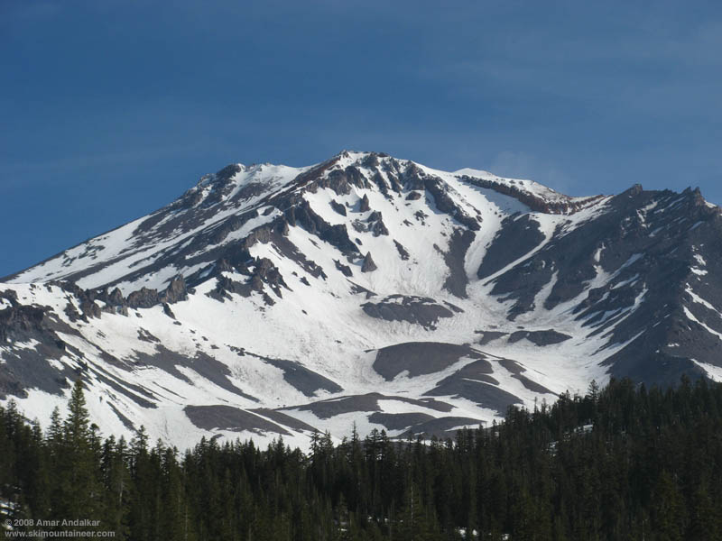
View of Avalanche Gulch from the trailhead in the morning.
So I got a very late start: I skinned up from 6950 ft Bunny Flat at 9:30am in warm sunshine, on 2-4 ft of very solid, heavily runneled and suncupped, summer-like snowpack. Skinned all the way to 11100 ft in Avalanche Gulch by 12:15pm, with fair weather puffy clouds occasionally rising up from lower elevations and enveloping me in a cool whiteout, but never threatening and eventually mostly dissipating. The snow had softened enough that ski crampons weren't needed, but the snow was generally very rough, runneled, suncupped, and even had areas of knee-to-thigh-high penitentes. The mountain was EMPTY, I saw only two skiers mid-morning from a great distance, descending the slopes above Helen Lake, and would see no one else until the end of the day.

Looking up through the Red Banks chimney, with a small waterfall at upper right.
I switched to booting up with crampons as the slope steepened and roughened further. My quick pace of the morning slowed greatly as a gusty headwind made upward progress challenging at times. There's lot of rockfall in Avy Gulch right now (helmet mandatory!), but most of it is well left of the climbing route by several hundred yards. A few rocks did cross the route below 11K, after I was well above that, so it's best to move quickly on the angling traverse below the Heart. Above the Heart, the route now cuts through a deep chimney in the Red Banks at about 12500 ft, a spectacular narrow finger of snow 4-6 ft wide in places, threading through reddish cliffs with waterfalls of meltwater cascading down. Icy snow in the 40-45 degree steep finger, along with an increasingly gusty headwind, required a bit of care and attention (I carried 2 Whippet self-arrest poles, but the ice axe stayed in the car). I reached the summit plateau at 13200 ft above Red Banks by 3pm, with temps of 33 F and the wind increasing to a steadier 30+ mph, coming straight from the direction of the true summit located nearly a mile NNE, up Misery Hill and across a second plateau. So the decision to abandon the summit was an easy one, especially as the skis on my pack were acting as nasty sails by now, twisting me rudely to and fro.

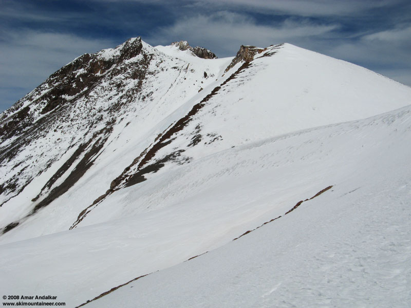
Looking east at the true summit (top center) from beside Point 13384.
I had planned to ski the West Face, which according to recent reports held decent snow in contrast to Avalanche Gulch, so I put the skis back on and skinned west across the plateau, relieved to find the wind now mostly at my back. Skinned up beside Point 13384, switched over, and skied down the icy frozen north-facing ridge towards the prominent gap atop the West Face at 3:45pm. The wind through the gap was closer to 50mph and threatening to either knock my off my skis or send me hurtling prematurely down the West Face. But as soon as I dropped through the gap onto the West Face, the winds eased dramatically and the snow softened immediately to corn. The so-called "West" Face actually faces WSW or nearly even SW, so it had gotten plenty of sun by this hour. It is most similar to the SW Chutes on Adams, although not quite as steep in general, mostly 35 degrees with sections approaching 40. The snow was decent, but not very smooth in many places, it appeared to have been heavily tracked and remelted. Probably because so many skiers are heading over to West Face this spring instead of just skiing down Avy Gulch as they would in most other years. But it was generally easy to just link turns down the smoothest (= whitest) areas of snow, then make short traverses to connect to other smooth patches
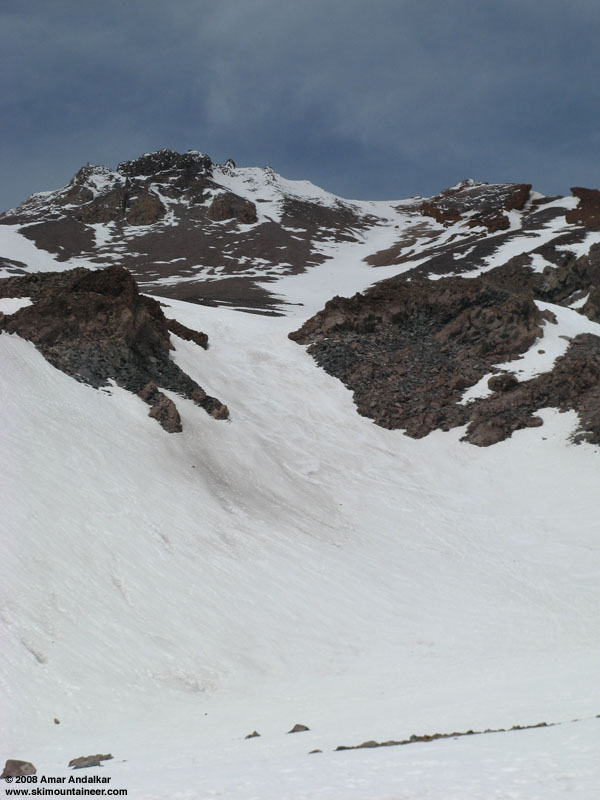
Looking all the way up the ski route on the West Face from Hidden Valley.
Snow quality remained good or OK all the way down to Hidden Valley at 9200 ft. Like the Adams SW Chutes, the steepest pitch of the West Face gully is at the very bottom, below 10000 ft where it rolls over to 40-45 degrees. Even there, the snow had no tendency to sluff or slide despite hours of sunhit by 4pm, the benefits of a well-consolidated summer-like snowpack. Below Hidden Valley, the snowpack had vanished on the steep west-facing exit slope, requiring a hike of nearly a half-mile, losing 400 ft of elevation, down the well-marked but deteriorating climber's trail. I finally saw the first people in many hours, a few climbers heading up the trail to make camp in Hidden Valley. After the hike, there was continuous snow from 8800 ft across Anaconda Gulch and Giddy Giddy Gulch all the way back to Horse Camp and out to the trailhead. Even at 5:30pm, this snow was neither very gloppy nor sticky despite the day-long heat.
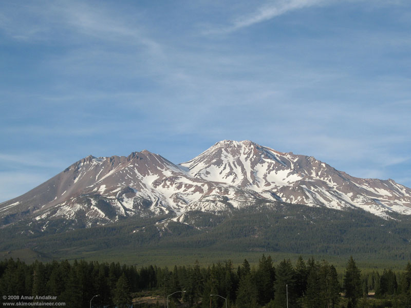
View of Shasta and the West Face in the evening from Abrams Lake Road overpass on I-5.
Overall, a fine day, with just over 6400 ft of ascent for over 6000 vert of skiing, and no regrets about passing up the summit. Been there plenty of times, and hopefully the events of last week on Rainier have permanently beaten summit fever out of me. Today has been a day of rest and photo-taking, followed by Lassen Peak tomorrow (the park road opened all the way through today, quite early compared to normal) and then maybe back to Shasta over the weekend. Hope that all my friends and everyone else in the Pacific Northwest are staying safe and avoiding any avalanches.
Other reports from this trip:
I only decided to head south quite late Tuesday morning (May 13), then spent all day packing, and got a late start from Seattle after evening rush hour. A long drive including a 3-4 hour nap at a rest area put me in Mt Shasta City right at 8am, perfect timing to buy an annual permit just as the USFS ranger station opened. The Mt Shasta forecast showed 14000 ft freezing levels yet with high winds, N-NE 35 mph at 10000 ft and N-NE 40 mph at 14000 ft, but I decided to head up anyway.
View of Avalanche Gulch from the trailhead in the morning.
So I got a very late start: I skinned up from 6950 ft Bunny Flat at 9:30am in warm sunshine, on 2-4 ft of very solid, heavily runneled and suncupped, summer-like snowpack. Skinned all the way to 11100 ft in Avalanche Gulch by 12:15pm, with fair weather puffy clouds occasionally rising up from lower elevations and enveloping me in a cool whiteout, but never threatening and eventually mostly dissipating. The snow had softened enough that ski crampons weren't needed, but the snow was generally very rough, runneled, suncupped, and even had areas of knee-to-thigh-high penitentes. The mountain was EMPTY, I saw only two skiers mid-morning from a great distance, descending the slopes above Helen Lake, and would see no one else until the end of the day.
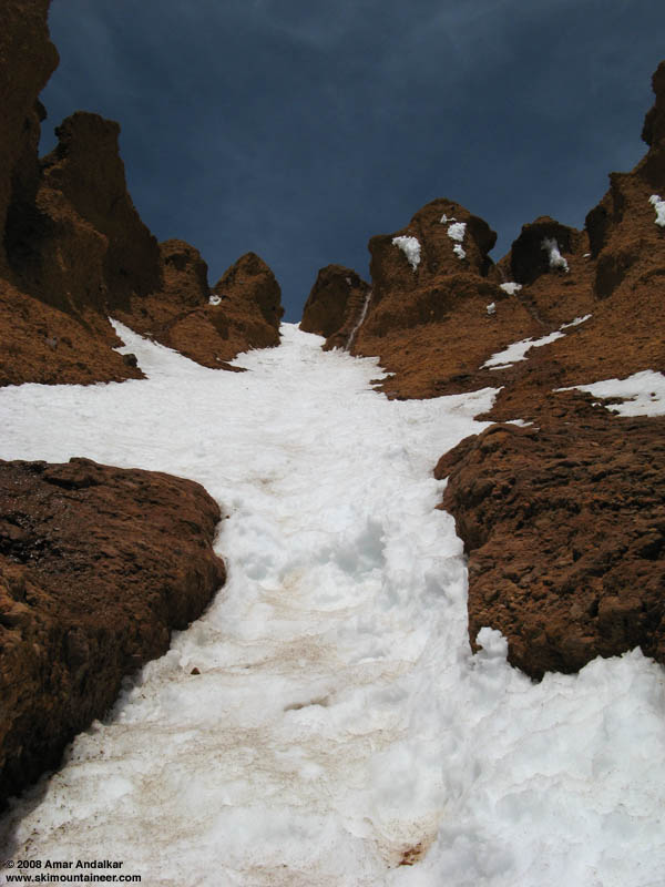
Looking up through the Red Banks chimney, with a small waterfall at upper right.
I switched to booting up with crampons as the slope steepened and roughened further. My quick pace of the morning slowed greatly as a gusty headwind made upward progress challenging at times. There's lot of rockfall in Avy Gulch right now (helmet mandatory!), but most of it is well left of the climbing route by several hundred yards. A few rocks did cross the route below 11K, after I was well above that, so it's best to move quickly on the angling traverse below the Heart. Above the Heart, the route now cuts through a deep chimney in the Red Banks at about 12500 ft, a spectacular narrow finger of snow 4-6 ft wide in places, threading through reddish cliffs with waterfalls of meltwater cascading down. Icy snow in the 40-45 degree steep finger, along with an increasingly gusty headwind, required a bit of care and attention (I carried 2 Whippet self-arrest poles, but the ice axe stayed in the car). I reached the summit plateau at 13200 ft above Red Banks by 3pm, with temps of 33 F and the wind increasing to a steadier 30+ mph, coming straight from the direction of the true summit located nearly a mile NNE, up Misery Hill and across a second plateau. So the decision to abandon the summit was an easy one, especially as the skis on my pack were acting as nasty sails by now, twisting me rudely to and fro.
Looking east at the true summit (top center) from beside Point 13384.
I had planned to ski the West Face, which according to recent reports held decent snow in contrast to Avalanche Gulch, so I put the skis back on and skinned west across the plateau, relieved to find the wind now mostly at my back. Skinned up beside Point 13384, switched over, and skied down the icy frozen north-facing ridge towards the prominent gap atop the West Face at 3:45pm. The wind through the gap was closer to 50mph and threatening to either knock my off my skis or send me hurtling prematurely down the West Face. But as soon as I dropped through the gap onto the West Face, the winds eased dramatically and the snow softened immediately to corn. The so-called "West" Face actually faces WSW or nearly even SW, so it had gotten plenty of sun by this hour. It is most similar to the SW Chutes on Adams, although not quite as steep in general, mostly 35 degrees with sections approaching 40. The snow was decent, but not very smooth in many places, it appeared to have been heavily tracked and remelted. Probably because so many skiers are heading over to West Face this spring instead of just skiing down Avy Gulch as they would in most other years. But it was generally easy to just link turns down the smoothest (= whitest) areas of snow, then make short traverses to connect to other smooth patches
Looking all the way up the ski route on the West Face from Hidden Valley.
Snow quality remained good or OK all the way down to Hidden Valley at 9200 ft. Like the Adams SW Chutes, the steepest pitch of the West Face gully is at the very bottom, below 10000 ft where it rolls over to 40-45 degrees. Even there, the snow had no tendency to sluff or slide despite hours of sunhit by 4pm, the benefits of a well-consolidated summer-like snowpack. Below Hidden Valley, the snowpack had vanished on the steep west-facing exit slope, requiring a hike of nearly a half-mile, losing 400 ft of elevation, down the well-marked but deteriorating climber's trail. I finally saw the first people in many hours, a few climbers heading up the trail to make camp in Hidden Valley. After the hike, there was continuous snow from 8800 ft across Anaconda Gulch and Giddy Giddy Gulch all the way back to Horse Camp and out to the trailhead. Even at 5:30pm, this snow was neither very gloppy nor sticky despite the day-long heat.
View of Shasta and the West Face in the evening from Abrams Lake Road overpass on I-5.
Overall, a fine day, with just over 6400 ft of ascent for over 6000 vert of skiing, and no regrets about passing up the summit. Been there plenty of times, and hopefully the events of last week on Rainier have permanently beaten summit fever out of me. Today has been a day of rest and photo-taking, followed by Lassen Peak tomorrow (the park road opened all the way through today, quite early compared to normal) and then maybe back to Shasta over the weekend. Hope that all my friends and everyone else in the Pacific Northwest are staying safe and avoiding any avalanches.
Other reports from this trip:
Thanks for the report. It is good to hear about places where the snowpack is behaving more as it is expected too. It is also nice to read about your take away from the Rainier epic.
what,! no near death experiences! You have recently become the Indiana Jones of ski touring( getting into dificult situations and then escaping them with style) , and I was expecting another adventure. ;)
Thanks for the TR, shame to see the mountain getting out of condition so soon in the year.
Thanks for the TR, shame to see the mountain getting out of condition so soon in the year.
Sounds mellower than your last jaunt!
Shasta was shoing rocks 1-1/2 months ago; quite the contrast between the far-south Cascades and up here.
Shasta was shoing rocks 1-1/2 months ago; quite the contrast between the far-south Cascades and up here.
Reply to this TR
Please login first: