- Posts: 5
- Thank you received: 0
Highway 20 will be closing this weekend - update it is close
- jersan
- [jersan]
-
 Topic Author
- Offline
- New Member
-

Less
More
15 May 2008 12:30 - 15 May 2008 12:48 #181800
by jersan
Highway 20 will be closing this weekend - update it is close was created by jersan
Below is from the DOT email I received today.... :-[
Hi all,
The North Cascades Highway is closing at 6 a.m. tomorrow morning unless it closes itself sooner than that. Our avalanche team won't go back in to reassess the conditions until Monday. Right now, they've got a couple dozen avalanche chutes between Diablo and Silver Star that are full and becoming more unstable by the hour as the temperature continues to climb. You'll find this information on our traffic and roads web page and on 5-1-1 and on the North Cascades web page and the information is also going out in a statewide news release from Olympia that will also include avalanche and snow melt and river level issues statewide. The NW Avalanche Center has also issued a back country avalanche warning advising everyone to stay home this weekend. You can stop reading now - that's the news - but to answer some questions you haven't asked yet: "No, avalanche control isn't an option under these conditions on the North Cascades." Here's why: As opposed to the passes that stay open all winter, we don't have any avalanche control facilities in place on SR 20. On Stevens, we've got two M-60 tanks positioned to shoot explosives into the starting zone of the avalanche chutes on the west side of the summit. We've also got a remote radio controlled box of rockets to address some avalanche chutes on the east side of the summit and we've got some snow-cat-usable trails cut above the starting zones of some of the other avalanche chutes that aren't in the range of either the tanks or the remote controlled rockets. (Those are the places where the avalanche crew has to drive up and set off satchel charges by hand. It's what Mike Stanford was doing in the 3 a.m., 100 mph wind video that KING TV ran back on Feb. 10 when we were closed for 54 hours. By the way, that's still available on the WSDOT YouTube site). The only avalanche control tool we've got for the North Cascades is the howitzer which can be mounted on the snow cat's trailer. It works okay to dislodge snow from the lower portions of Liberty Bell's chutes, but most of the other chute's starting zones are out of range and we don't have any snow cat trails cut in because that's Park Service or Forest Service land and for a highway that's closed 5 months a year, it would be pretty hard to justify putting those kinds of permanent "roads" in place. Besides that, we couldn't put them in above a lot of chutes at all, due to the terrain. The North Cascades, besides having more avalanche chutes than anywhere else, also has some of the tallest/longest ones. Delivering ordinance to the top of an avalanche chute that starts between 7 and 9,000 feet isn't feasible. This weekend's situation is highly unusual in that by this time of year, the chutes aren't still full. This spring has been so cold that, while full, the chutes have remained stable. This 30+ degree rise heats up the top layer of snow, making it heavier and creating a slip-plane with the layer below. That's what's happening now and if it slides, what's coming down is going to have the consistency of wet concrete and will probably bring rocks and wood debris with it, so you wouldn't want to be on the highway when that happens. If they find significant slides on Monday - it could take several days to clean up. All we can do is tell you to check the web pages or call 5-1-1. I'll send another e mail Monday when the crew gets back in radio range and tells me what they found and what happens next.
Jeff
Subject: It closed itself - Now.
Hi all,
It happened. The highway closed itself. We're getting slides now - the crew is cleaning up one at Liberty Bell #2 that came down a little while ago. The gates won't actually be closed and locked for another couple of hours since we've got cars parked up there and we've got to find and get those recreational users out. In the meantime, we don't want anybody else up there because we don't know when or where the next slide is going to come. (But we know it will!)
Jeff
Hi all,
The North Cascades Highway is closing at 6 a.m. tomorrow morning unless it closes itself sooner than that. Our avalanche team won't go back in to reassess the conditions until Monday. Right now, they've got a couple dozen avalanche chutes between Diablo and Silver Star that are full and becoming more unstable by the hour as the temperature continues to climb. You'll find this information on our traffic and roads web page and on 5-1-1 and on the North Cascades web page and the information is also going out in a statewide news release from Olympia that will also include avalanche and snow melt and river level issues statewide. The NW Avalanche Center has also issued a back country avalanche warning advising everyone to stay home this weekend. You can stop reading now - that's the news - but to answer some questions you haven't asked yet: "No, avalanche control isn't an option under these conditions on the North Cascades." Here's why: As opposed to the passes that stay open all winter, we don't have any avalanche control facilities in place on SR 20. On Stevens, we've got two M-60 tanks positioned to shoot explosives into the starting zone of the avalanche chutes on the west side of the summit. We've also got a remote radio controlled box of rockets to address some avalanche chutes on the east side of the summit and we've got some snow-cat-usable trails cut above the starting zones of some of the other avalanche chutes that aren't in the range of either the tanks or the remote controlled rockets. (Those are the places where the avalanche crew has to drive up and set off satchel charges by hand. It's what Mike Stanford was doing in the 3 a.m., 100 mph wind video that KING TV ran back on Feb. 10 when we were closed for 54 hours. By the way, that's still available on the WSDOT YouTube site). The only avalanche control tool we've got for the North Cascades is the howitzer which can be mounted on the snow cat's trailer. It works okay to dislodge snow from the lower portions of Liberty Bell's chutes, but most of the other chute's starting zones are out of range and we don't have any snow cat trails cut in because that's Park Service or Forest Service land and for a highway that's closed 5 months a year, it would be pretty hard to justify putting those kinds of permanent "roads" in place. Besides that, we couldn't put them in above a lot of chutes at all, due to the terrain. The North Cascades, besides having more avalanche chutes than anywhere else, also has some of the tallest/longest ones. Delivering ordinance to the top of an avalanche chute that starts between 7 and 9,000 feet isn't feasible. This weekend's situation is highly unusual in that by this time of year, the chutes aren't still full. This spring has been so cold that, while full, the chutes have remained stable. This 30+ degree rise heats up the top layer of snow, making it heavier and creating a slip-plane with the layer below. That's what's happening now and if it slides, what's coming down is going to have the consistency of wet concrete and will probably bring rocks and wood debris with it, so you wouldn't want to be on the highway when that happens. If they find significant slides on Monday - it could take several days to clean up. All we can do is tell you to check the web pages or call 5-1-1. I'll send another e mail Monday when the crew gets back in radio range and tells me what they found and what happens next.
Jeff
Subject: It closed itself - Now.
Hi all,
It happened. The highway closed itself. We're getting slides now - the crew is cleaning up one at Liberty Bell #2 that came down a little while ago. The gates won't actually be closed and locked for another couple of hours since we've got cars parked up there and we've got to find and get those recreational users out. In the meantime, we don't want anybody else up there because we don't know when or where the next slide is going to come. (But we know it will!)
Jeff
Please Log in or Create an account to join the conversation.
- korup
- [korup]
-
- Offline
- Junior Member
-

Less
More
- Posts: 220
- Thank you received: 0
15 May 2008 16:33 #181805
by korup
Replied by korup on topic Re: Highway 20 will be closing this weekend - update it is c
Part of me is really curious what "Slides may release to or near the ground, involving the entire winter’s snowpack" from the NWAC report for the weekend might look like, but I think I'll wait for photos.
Please Log in or Create an account to join the conversation.
- Pete A
- [Bud]
-
- Offline
- Senior Member
-

Less
More
- Posts: 431
- Thank you received: 0
15 May 2008 17:03 #181807
by Pete A
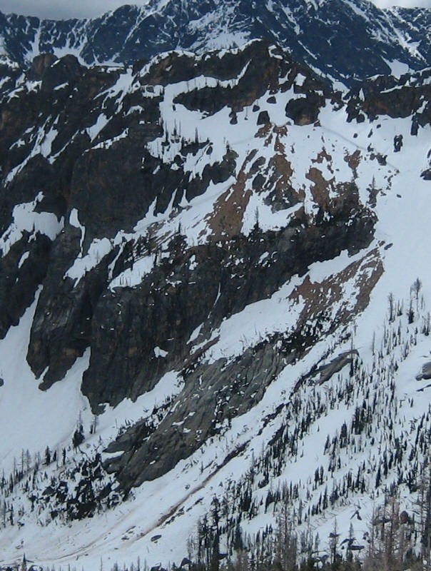
climax releases from the 2006 ski season
pic 1 (kangaroo ridge)
pic 2 (windy ridge near stevens pass)
Replied by Pete A on topic Re: Highway 20 will be closing this weekend - update it is c
Part of me is really curious what "Slides may release to or near the ground, involving the entire winter’s snowpack" from the NWAC report for the weekend might look like, but I think I'll wait for photos.
climax releases from the 2006 ski season
pic 1 (kangaroo ridge)
pic 2 (windy ridge near stevens pass)
Please Log in or Create an account to join the conversation.
- korup
- [korup]
-
- Offline
- Junior Member
-
Less
More
- Posts: 220
- Thank you received: 0
16 May 2008 07:49 #181810
by korup
Replied by korup on topic Re: Highway 20 will be closing this weekend - update it is c
Is there a "Holy Crap Batman" emoticon?!?!?!
Please Log in or Create an account to join the conversation.
- Marcus
- [Marcus]
-
- Offline
- Platinum Member
-

Less
More
- Posts: 1230
- Thank you received: 0
16 May 2008 09:05 #181811
by Marcus
Replied by Marcus on topic Re: Highway 20 will be closing this weekend - update it is close
Holy crap! Great pictures Larry -- very curious to hear more about that...
Please Log in or Create an account to join the conversation.
- garyabrill
- [garyabrill]
-
- Offline
- Senior Member
-
Less
More
- Posts: 464
- Thank you received: 0
16 May 2008 11:15 - 16 May 2008 11:19 #181812
by garyabrill
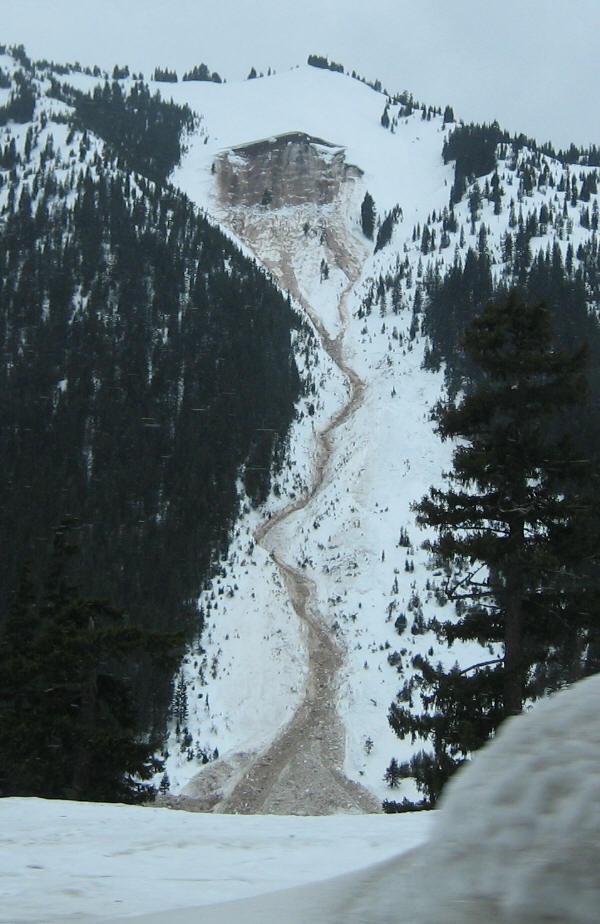
Looks like it might have been a little hard to outrun that hummer while waddling around in calf deep wet snow! It kinda shows why sometimes it's better to just say no, doesn't it?
I would think that with the crown in the 6500 to 7000' range, it would be a safe bet that that it must be at least 16'. It also shows the affect of faceting early this winter where cold temperatures were the norm for much of the winter.
Also the telemetry already shows the story. Warm daytime temperatures so far into the 60's and more ominous nightime low only into the 50's, just ten degrees cooler than the high temps.
Replied by garyabrill on topic Re: Highway 20 will be closing this weekend - update it is c
Ask and ye shall receive,
Here are a few pics from yesterday below Mesahchie Pass; before, after and the crown face. Trip report hopefully soon by photographer in photo.
Larry
Looks like it might have been a little hard to outrun that hummer while waddling around in calf deep wet snow! It kinda shows why sometimes it's better to just say no, doesn't it?
I would think that with the crown in the 6500 to 7000' range, it would be a safe bet that that it must be at least 16'. It also shows the affect of faceting early this winter where cold temperatures were the norm for much of the winter.
Also the telemetry already shows the story. Warm daytime temperatures so far into the 60's and more ominous nightime low only into the 50's, just ten degrees cooler than the high temps.
Please Log in or Create an account to join the conversation.
- John Morrow
- [John_Morrow]
-
- Offline
- Junior Member
-
Less
More
- Posts: 103
- Thank you received: 0
16 May 2008 11:49 - 16 May 2008 11:55 #181813
by John Morrow
Replied by John Morrow on topic Re: Highway 20 will be closing this weekend - update it is close
I know it's one too many photos, but I gotta do a "before and after".
John
John
Please Log in or Create an account to join the conversation.
- Marcus
- [Marcus]
-
- Offline
- Platinum Member
-
Less
More
- Posts: 1230
- Thank you received: 0
16 May 2008 12:59 #181815
by Marcus
Replied by Marcus on topic Re: Highway 20 will be closing this weekend - update it is close
I was wondering if those were yours John... when was that before taken? Lost a few trees on that slope, by the picture. Wonga...
Please Log in or Create an account to join the conversation.
- Lowell_Skoog
- [Lowell_Skoog]
-

- Offline
- Platinum Member
-
Less
More
- Posts: 1460
- Thank you received: 16
16 May 2008 14:12 - 16 May 2008 14:22 #181816
by Lowell_Skoog
Replied by Lowell_Skoog on topic Re: Highway 20 will be closing this weekend - update it is close
The good news: There's a lot of stabilizing goin' on right now (just don't be underneath when it happens).
The bad news: Those beautiful slopes we'd love to ski are getting trashed. I wonder how widespread the avalanche scouring and debris will be after this warm cycle passes. You can see in John's before and after pictures that those slopes would have been nice smooth skiing a week ago. Now...yuck.
BTW: I'm glad you guys got out of there safely. That's an eye opener!
Please Log in or Create an account to join the conversation.
- ski_photomatt
- [ski_photomatt]
-
- Offline
- Junior Member
-
Less
More
- Posts: 141
- Thank you received: 0
16 May 2008 14:41 #181817
by ski_photomatt
Replied by ski_photomatt on topic Re: Highway 20 will be closing this weekend - update it is close
I've skied through this valley twice and both times have been very impressed at the size of the debris (it has looked something like the after shots above). Although it isn't particularly large, it seems to collect more debris then most of the other valleys along the highway. It is relatively narrow side to side, but it is bordered by a very steep N-NE facing slope with huge cliffs below a steep ridge. The ridge grows huge overhanging cornices. It probably doesn't get much sun during the winter and early spring so doesn't incrementally stabilize as much as a sunnier slope. All these things would contribute to climax slides in the spring.
Please Log in or Create an account to join the conversation.
- John Morrow
- [John_Morrow]
-
- Offline
- Junior Member
-
Less
More
- Posts: 103
- Thank you received: 0
16 May 2008 15:50 - 16 May 2008 16:30 #181818
by John Morrow
While Larry and I were in a safe camp watching wet slide after wet slide (all point releases) fall harmlessly below us, he came up with an interesting hypothesis. In addition to that slope being a face of more than 2500 vertical feet of cliffs punctuated with steep snowfields and an east aspect, it also is somewhat concave (amphitheater) shaped and thus enhances the heating effect.
Replied by John Morrow on topic Re: Highway 20 will be closing this weekend - update it is close
Interesting, Matt.I've skied through this valley twice and both times have been very impressed at the size of the debris (it has looked something like the after shots above). Although it isn't particularly large, it seems to collect more debris then most of the other valleys along the highway. It is relatively narrow side to side, but it is bordered by a very steep N-NE facing slope with huge cliffs below a steep ridge. The ridge grows huge overhanging cornices. It probably doesn't get much sun during the winter and early spring so doesn't incrementally stabilize as much as a sunnier slope. All these things would contribute to climax slides in the spring.
While Larry and I were in a safe camp watching wet slide after wet slide (all point releases) fall harmlessly below us, he came up with an interesting hypothesis. In addition to that slope being a face of more than 2500 vertical feet of cliffs punctuated with steep snowfields and an east aspect, it also is somewhat concave (amphitheater) shaped and thus enhances the heating effect.
Please Log in or Create an account to join the conversation.
- Lowell_Skoog
- [Lowell_Skoog]
-
- Offline
- Platinum Member
-
Less
More
- Posts: 1460
- Thank you received: 16
16 May 2008 15:53 #181819
by Lowell_Skoog
You're right. That valley is usually full of debris and it's rare to see it otherwise. I'm sure lots of nice slopes won't get swept during this cycle, but it will be interesting to see what does get trashed.
Replied by Lowell_Skoog on topic Re: Highway 20 will be closing this weekend - update it is close
All these things would contribute to climax slides in the spring.
You're right. That valley is usually full of debris and it's rare to see it otherwise. I'm sure lots of nice slopes won't get swept during this cycle, but it will be interesting to see what does get trashed.
Please Log in or Create an account to join the conversation.
- John Morrow
- [John_Morrow]
-
- Offline
- Junior Member
-
Less
More
- Posts: 103
- Thank you received: 0
16 May 2008 15:53 #181820
by John Morrow
Hi Marcus,
The before was on Wednesday at about 6:00PM, and the after was when Larry and I were returning from a different basin at about 11:00AM. We were up by 5:00AM yesterday to start the day and that was still not quite early enough!
John
Replied by John Morrow on topic Re: Highway 20 will be closing this weekend - update it is close
I was wondering if those were yours John... when was that before taken? Lost a few trees on that slope, by the picture. Wonga...
Hi Marcus,
The before was on Wednesday at about 6:00PM, and the after was when Larry and I were returning from a different basin at about 11:00AM. We were up by 5:00AM yesterday to start the day and that was still not quite early enough!
John
Please Log in or Create an account to join the conversation.
- garyabrill
- [garyabrill]
-
- Offline
- Senior Member
-
Less
More
- Posts: 464
- Thank you received: 0
17 May 2008 11:27 #181823
by garyabrill
The thing that bothers me about Kitling Creek valley, with it's very steep sides and narrow confines is just how fast a slide would get onto one. There would be almost no reaction time and nowhere to go if it did slide. The duration of exposure round trip must be on the order of some 2-1/2 hours and that's a lot of exposure in a natural avalanche cycle.
Hey, John, what did you guys think of conditions as you were heading up? It must have already been pretty warm given the evidence of the large deep slab while you were there?
Replied by garyabrill on topic Re: Highway 20 will be closing this weekend - update it is close
Interesting, Matt.
While Larry and I were in a safe camp watching wet slide after wet slide (all point releases) fall harmlessly below us, he came up with an interesting hypothesis. In addition to that slope being a face of more than 2500 vertical feet of cliffs punctuated with steep snowfields and an east aspect, it also is somewhat concave (amphitheater) shaped and thus enhances the heating effect.
The thing that bothers me about Kitling Creek valley, with it's very steep sides and narrow confines is just how fast a slide would get onto one. There would be almost no reaction time and nowhere to go if it did slide. The duration of exposure round trip must be on the order of some 2-1/2 hours and that's a lot of exposure in a natural avalanche cycle.
Hey, John, what did you guys think of conditions as you were heading up? It must have already been pretty warm given the evidence of the large deep slab while you were there?
Please Log in or Create an account to join the conversation.
- John Morrow
- [John_Morrow]
-
- Offline
- Junior Member
-
Less
More
- Posts: 103
- Thank you received: 0
17 May 2008 12:27 #181824
by John Morrow
Hi Gary,
Actually on Tuesday it was about 32 degrees and snowing on our approach. We car camped the night before, started up by 8:00 AM, and were in camp before the snow began to turn to rain. Believe it or not, I had hopes of some new snow on the northwest aspects above 6000 feet Wed. morning with a very early start out of camp. But it rained all the way to 8000 feet. There were no slides at all of any size or type on Tuesday, which was a bit surprising to us that nothing moved even late in the afternoon. Wed. the sun never came out and the cloud ceiling stayed below 7000 feet. The high temp. in camp was about 42 degrees. However, the cloud cover would have been a false sense of security if one was to approach on Wed. because there was enough solar heat coming through that point releases were common after about 2:00PM. Yet none of these actually even reached the valley floor below. They were slower wet slides that came to a stop on the side slope avalanche fans. The rain that percolated through the snowpack by then may have had more of an effect than the heat, or perhaps a combination of both. Certainly by Thurs. noonish the intense sun of that morning on the east face, combined with the free water in the snowpack, gave it what it needed to release so big. If we made a mistake it was to decide to go up for a ski Thursday morning and not just descend and get out of the Kitling Creek valley early. We knew we had a forested exit on the north side of the drainage up out of the valley floor. In hindsight, maybe a very large slide could have been so destructive as to climb up the opposite side (north side) of the valley floor and take out mature trees.
Thanks for asking, discussion is definitely useful.
John
Replied by John Morrow on topic Re: Highway 20 will be closing this weekend - update it is close
Hey, John, what did you guys think of conditions as you were heading up? It must have already been pretty warm given the evidence of the large deep slab while you were there?
Hi Gary,
Actually on Tuesday it was about 32 degrees and snowing on our approach. We car camped the night before, started up by 8:00 AM, and were in camp before the snow began to turn to rain. Believe it or not, I had hopes of some new snow on the northwest aspects above 6000 feet Wed. morning with a very early start out of camp. But it rained all the way to 8000 feet. There were no slides at all of any size or type on Tuesday, which was a bit surprising to us that nothing moved even late in the afternoon. Wed. the sun never came out and the cloud ceiling stayed below 7000 feet. The high temp. in camp was about 42 degrees. However, the cloud cover would have been a false sense of security if one was to approach on Wed. because there was enough solar heat coming through that point releases were common after about 2:00PM. Yet none of these actually even reached the valley floor below. They were slower wet slides that came to a stop on the side slope avalanche fans. The rain that percolated through the snowpack by then may have had more of an effect than the heat, or perhaps a combination of both. Certainly by Thurs. noonish the intense sun of that morning on the east face, combined with the free water in the snowpack, gave it what it needed to release so big. If we made a mistake it was to decide to go up for a ski Thursday morning and not just descend and get out of the Kitling Creek valley early. We knew we had a forested exit on the north side of the drainage up out of the valley floor. In hindsight, maybe a very large slide could have been so destructive as to climb up the opposite side (north side) of the valley floor and take out mature trees.
Thanks for asking, discussion is definitely useful.
John
Please Log in or Create an account to join the conversation.
- garyabrill
- [garyabrill]
-
- Offline
- Senior Member
-
Less
More
- Posts: 464
- Thank you received: 0
20 May 2008 15:29 #181840
by garyabrill
Thanks, John, for a very good synopsis. I kind of figured the weather must have either snuck up on you a little quicker than you expected or that conditions were not that unfavorable when you set out. Those big slides sure must have been an eye opener.
Replied by garyabrill on topic Re: Highway 20 will be closing this weekend - update it is close
Hi Gary,
Actually on Tuesday it was about 32 degrees and snowing on our approach. We car camped the night before, started up by 8:00 AM, and were in camp before the snow began to turn to rain. Believe it or not, I had hopes of some new snow on the northwest aspects above 6000 feet Wed. morning with a very early start out of camp. But it rained all the way to 8000 feet. There were no slides at all of any size or type on Tuesday, which was a bit surprising to us that nothing moved even late in the afternoon. Wed. the sun never came out and the cloud ceiling stayed below 7000 feet. The high temp. in camp was about 42 degrees. However, the cloud cover would have been a false sense of security if one was to approach on Wed. because there was enough solar heat coming through that point releases were common after about 2:00PM. Yet none of these actually even reached the valley floor below. They were slower wet slides that came to a stop on the side slope avalanche fans. The rain that percolated through the snowpack by then may have had more of an effect than the heat, or perhaps a combination of both. Certainly by Thurs. noonish the intense sun of that morning on the east face, combined with the free water in the snowpack, gave it what it needed to release so big. If we made a mistake it was to decide to go up for a ski Thursday morning and not just descend and get out of the Kitling Creek valley early. We knew we had a forested exit on the north side of the drainage up out of the valley floor. In hindsight, maybe a very large slide could have been so destructive as to climb up the opposite side (north side) of the valley floor and take out mature trees.
Thanks for asking, discussion is definitely useful.
John
Thanks, John, for a very good synopsis. I kind of figured the weather must have either snuck up on you a little quicker than you expected or that conditions were not that unfavorable when you set out. Those big slides sure must have been an eye opener.
Please Log in or Create an account to join the conversation.
- jersan
- [jersan]
-
Topic Author
- Offline
- New Member
-
Less
More
- Posts: 5
- Thank you received: 0
20 May 2008 16:30 #181841
by jersan
Replied by jersan on topic Re: Highway 20 will be closing this weekend - update it is close
From: Jeff Adamson [This email address is being protected from spambots. You need JavaScript enabled to view it.]
> Sent: Tuesday, May 20, 2008 3:08 PM
> To: Sanchez, Jerry
> Subject: It's open (again)
Hi all,
The gates near Diablo and Mazama swung open at 3 p.m. this afternoon
allowing you to travel between the Skagit and Methow Valleys for the
first time in 5 days. Yesterday, our avalanche crew found a large slide,
blocking the highway below Liberty #3. Heavy, wet snow, large rocks and
tree debris covered 200-feet of the highway to a depth of 25 to 35 feet.
Our crews cleared the slides, repaired a sinkhole and cleared about a
half dozen clogged culverts where avalanche chutes released and dumped
snow and rocks on the shoulders. Photos of the slide and sinkhole can be
iewed on the WSDOT flickr web site:
ww.flickr.com/photos/wsdot/sets/72157605163524499/
The snow has stabilized and weather forecasts don't suggest any
conditions that would close the highway for the upcoming Memorial Day
weekend. It just might actually get to be spring!
Please Log in or Create an account to join the conversation.
- jersan
- [jersan]
-
Topic Author
- Offline
- New Member
-
Less
More
- Posts: 5
- Thank you received: 0
20 May 2008 16:32 #181842
by jersan
Replied by jersan on topic Re: Highway 20 will be closing this weekend - update it is close
Please Log in or Create an account to join the conversation.